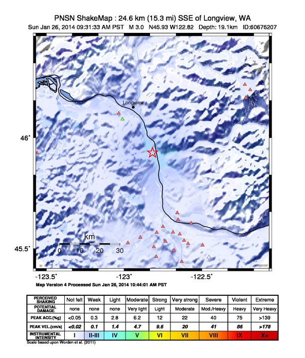
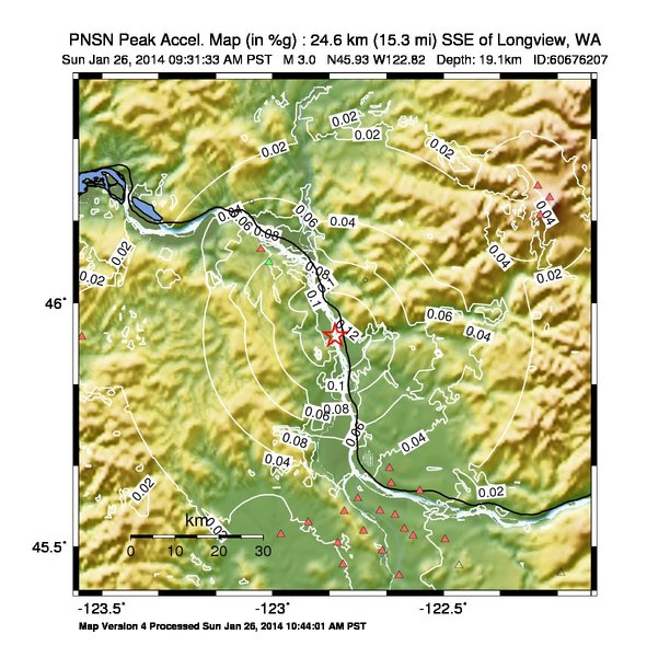
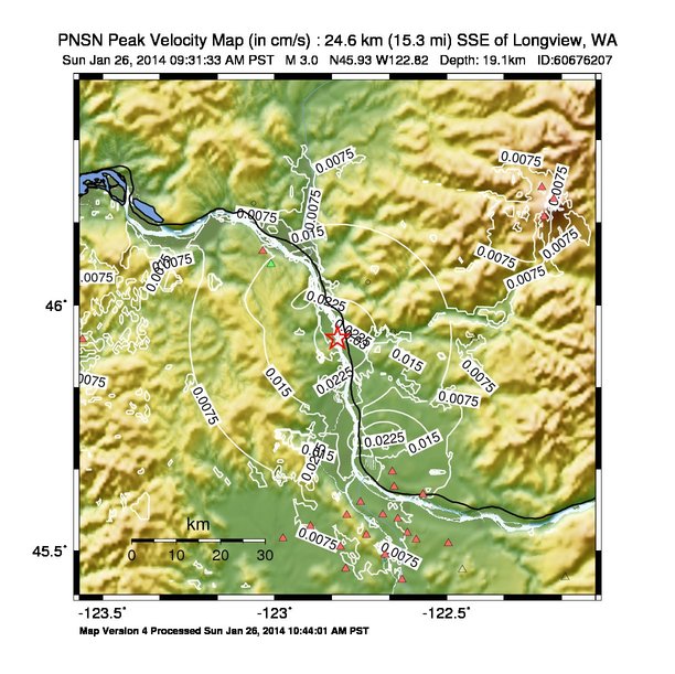
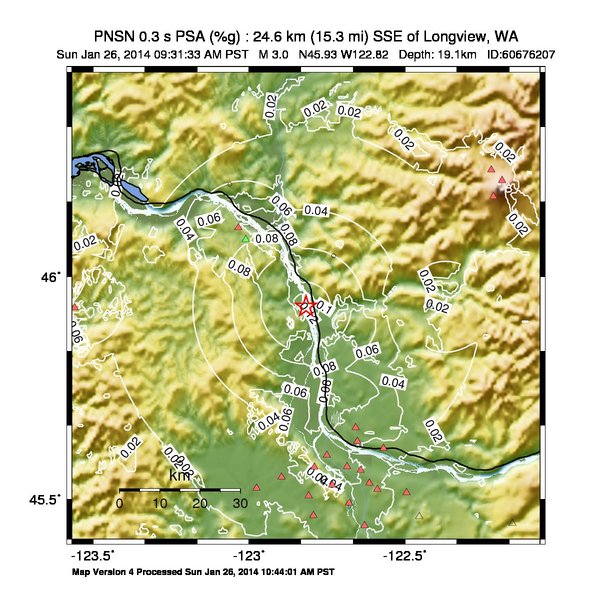
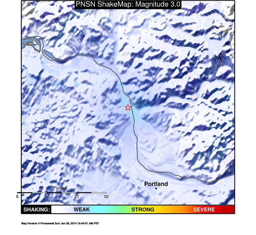
ShakeMap
Time:
Sun January 26, 2014 17:31:33 (UTC)
|
Depth:
19.96 km
|
Event ID:
60676207
|
Location:
45.934, -122.825
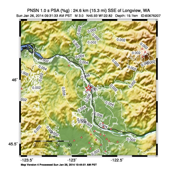
Pseudo Acceleration Spectra

Downloads
| Regional | |
|---|---|
| intensity | JPG | PS.ZIP |
| acceleration | JPG | PS.ZIP |
| velocity | JPG | PS.ZIP |
| spectral 0.3 | JPG | PS.ZIP |
| spectral 1.0 | JPG | PS.ZIP |
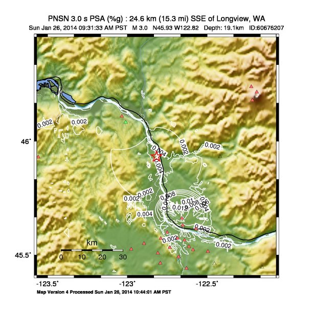
| spectral 3.0 | JPG | PS.ZIP |
| uncertainty | JPG | PS.ZIP |
| tv map | JPG | PS.ZIP |
| tv map bare | JPG | PS.ZIP |
| tv info sheet | TXT |
| grid | XYZ.ZIP | XML.ZIP |
| gis | ZIP |
| station | TXT | XML |
| metadata | TXT |
Earthquake
| Event ID | Magnitude | Date | Time | Lat | Lon | Depth |
| 60676207 | 3.0 | 1/26/2014 | 09:31:33 PST | N45.9327 | W122.8175 | 19.05 km |
| Magnitude Bias: | MMI | PGA | PGV | PSA 0.3 | PSA 1.0 | PSA 3.0 |
| -1.58 | 0.04 | 0.05 | 0.11 | 0.22 | 0.70 |
Seismic Stations
| 1: | ZIP Code 98625 Kalama (Intensity III, 5 responses) | Agency: USGS (Did You Feel It?) | |||
| Lat: 46.0464 Lon: -122.7289 Distance: 14.4 km from source | |||||
| Intensity: 2.6 | |||||
| Station Comp | Max Vel (cm/s) | Max Acc (%g) | PSA: 0.3 sec (%g) | 1.0 sec (%g) | 3.0 sec (%g) |
| DERIVED | -- | -- | -- | -- | -- |
| 2: | ZIP Code 98632 Longview (Intensity II, 3 responses) | Agency: USGS (Did You Feel It?) | |||
| Lat: 46.2055 Lon: -123.0617 Distance: 35.7 km from source | |||||
| Intensity: 2.5 | |||||
| Station Comp | Max Vel (cm/s) | Max Acc (%g) | PSA: 0.3 sec (%g) | 1.0 sec (%g) | 3.0 sec (%g) |
| DERIVED | -- | -- | -- | -- | -- |
| 3: | ZIP Code 98674 Woodland (Intensity II, 7 responses) | Agency: USGS (Did You Feel It?) | |||
| Lat: 45.9473 Lon: -122.6557 Distance: 12.6 km from source | |||||
| Intensity: 2.4 | |||||
| Station Comp | Max Vel (cm/s) | Max Acc (%g) | PSA: 0.3 sec (%g) | 1.0 sec (%g) | 3.0 sec (%g) |
| DERIVED | -- | -- | -- | -- | -- |
| CC.STD: | Studebaker Ridge, Mount St Helens, WA | Agency: Cascade Volcano Obervatory | |||
| Lat: 46.2376 Lon: -122.2240 Distance: 60.1 km from source | |||||
| Intensity: 1.0 | |||||
| Station Comp | Max Vel (cm/s) | Max Acc (%g) | PSA: 0.3 sec (%g) | 1.0 sec (%g) | 3.0 sec (%g) |
| --.BHE | 0.0061 | 0.0348 | 0.0221 | 0.0010 | 0.0001 |
| --.BHN | 0.0029 | 0.0179 | 0.0142 | 0.0004 | 0.0000 |
| CC.SWF2: | Southwest Flank 2, Mt. St. Helens, WA | Agency: Cascade Volcano Obervatory | |||
| Lat: 46.1784 Lon: -122.2168 Distance: 57.1 km from source | |||||
| Intensity: 1.0 | |||||
| Station Comp | Max Vel (cm/s) | Max Acc (%g) | PSA: 0.3 sec (%g) | 1.0 sec (%g) | 3.0 sec (%g) |
| --.BHE | 0.0062 | 0.0397 | 0.0277 | 0.0020 | 0.0001 |
| --.BHN | 0.0083 | 0.0454 | 0.0260 | 0.0010 | 0.0001 |
| CC.VALT: | Mt. St. Helens Crater, WA | Agency: Cascade Volcano Obervatory | |||
| Lat: 46.2142 Lon: -122.1893 Distance: 60.8 km from source | |||||
| Intensity: 1.0 | |||||
| Station Comp | Max Vel (cm/s) | Max Acc (%g) | PSA: 0.3 sec (%g) | 1.0 sec (%g) | 3.0 sec (%g) |
| --.BHE | 0.0047 | 0.0270 | 0.0150 | 0.0019 | 0.0001 |
| --.BHN | 0.0062 | 0.0273 | 0.0205 | 0.0017 | 0.0001 |
| TA.F04D: | Rainier, OR, USA | Agency: USArray Transportable Array | |||
| Lat: 46.0829 Lon: -123.0108 Distance: 29.4 km from source | |||||
| Intensity: 1.1 | |||||
| Station Comp | Max Vel (cm/s) | Max Acc (%g) | PSA: 0.3 sec (%g) | 1.0 sec (%g) | 3.0 sec (%g) |
| --.BHE | 0.0152 | 0.0727 | 0.0460 | 0.0032 | 0.0002 |
| --.BHN | 0.0168 | 0.0726 | 0.0598 | 0.0038 | 0.0003 |
| UW.ALST: | Alston BPA site, Oregon - SMO | Agency: Pacific Northwest Regional Seismic Network | |||
| Lat: 46.1088 Lon: -123.0341 Distance: 32.0 km from source | |||||
| Intensity: 1.0 | |||||
| Station Comp | Max Vel (cm/s) | Max Acc (%g) | PSA: 0.3 sec (%g) | 1.0 sec (%g) | 3.0 sec (%g) |
| --.ENN | 0.0066 | 0.0358 | 0.0138 | 0.0010 | 0.0003 |
| --.ENE | 0.0135 | 0.0923 | 0.1004 | 0.0039 | 0.0004 |
| UW.BULL: | Bull Run Dam, Portland OR SMO-IDS24 | Agency: Pacific Northwest Regional Seismic Network | |||
| Lat: 45.4459 Lon: -122.1559 Distance: 77.0 km from source | |||||
| Intensity: nan | |||||
| Station Comp | Max Vel (cm/s) | Max Acc (%g) | PSA: 0.3 sec (%g) | 1.0 sec (%g) | 3.0 sec (%g) |
| --.ENN | 0.0011 -G | 0.0004 -G | 0.0004 -G | 0.0004 -G | 0.0002 -G |
| --.ENE | 0.0011 -G | 0.0005 -G | 0.0003 -G | 0.0005 -G | 0.0002 -G |
| UW.FISH: | Seaside, OR, USA | Agency: Pacific Northwest Regional Seismic Network | |||
| Lat: 45.9306 Lon: -123.5591 Distance: 60.4 km from source | |||||
| Intensity: 1.0 | |||||
| Station Comp | Max Vel (cm/s) | Max Acc (%g) | PSA: 0.3 sec (%g) | 1.0 sec (%g) | 3.0 sec (%g) |
| --.HHE | 0.0122 | 0.0389 | 0.0854 | 0.0036 | 0.0003 |
| --.HHN | 0.0000 | 0.0000 | 0.0000 | 0.0000 | 0.0000 |
| UW.HUBA: | Hudson Bay HS, ANSS SMO | Agency: Pacific Northwest Regional Seismic Network | |||
| Lat: 45.6307 Lon: -122.6526 Distance: 40.7 km from source | |||||
| Intensity: 1.0 | |||||
| Station Comp | Max Vel (cm/s) | Max Acc (%g) | PSA: 0.3 sec (%g) | 1.0 sec (%g) | 3.0 sec (%g) |
| --.ENN | 0.0125 | 0.0411 | 0.0575 | 0.0023 | 0.0003 |
| --.ENE | 0.0050 | 0.0207 | 0.0222 | 0.0009 | 0.0005 |
| UW.KEEL: | Keeler BPA site, Oregon - SMO | Agency: Pacific Northwest Regional Seismic Network | |||
| Lat: 45.5501 Lon: -122.8963 Distance: 47.0 km from source | |||||
| Intensity: 1.0 | |||||
| Station Comp | Max Vel (cm/s) | Max Acc (%g) | PSA: 0.3 sec (%g) | 1.0 sec (%g) | 3.0 sec (%g) |
| --.ENN | 0.0061 | 0.0136 | 0.0208 | 0.0028 | 0.0004 |
| --.ENE | 0.0042 | 0.0171 | 0.0177 | 0.0018 | 0.0003 |
| UW.PGO: | Gresham, Oregon | Agency: Pacific Northwest Regional Seismic Network | |||
| Lat: 45.4617 Lon: -122.4544 Distance: 62.5 km from source | |||||
| Intensity: nan | |||||
| Station Comp | Max Vel (cm/s) | Max Acc (%g) | PSA: 0.3 sec (%g) | 1.0 sec (%g) | 3.0 sec (%g) |
| --.ENN | 0.0036 -G | 0.0090 -G | 0.0111 -G | 0.0006 -G | 0.0002 -G |
| --.ENE | 0.0031 | 0.0114 | 0.0144 | 0.0009 | 0.0002 |
| UW.QAMI: | Birchwood Dr. Hillsboro, OR | Agency: Pacific Northwest Regional Seismic Network | |||
| Lat: 45.5256 Lon: -122.9761 Distance: 50.6 km from source | |||||
| Intensity: 1.0 | |||||
| Station Comp | Max Vel (cm/s) | Max Acc (%g) | PSA: 0.3 sec (%g) | 1.0 sec (%g) | 3.0 sec (%g) |
| --.HNZ | 0.0063 | 0.0248 | 0.0058 | 0.0028 | 0.0035 |
| --.HNN | 0.0042 | 0.0092 | 0.0204 | 0.0033 | 0.0021 |
| --.HNE | 0.0048 | 0.0116 | 0.0323 | 0.0021 | 0.0014 |
| UW.QDAD: | SE 32nd Portland, OR | Agency: Pacific Northwest Regional Seismic Network | |||
| Lat: 45.4408 Lon: -122.6295 Distance: 59.7 km from source | |||||
| Intensity: 1.0 | |||||
| Station Comp | Max Vel (cm/s) | Max Acc (%g) | PSA: 0.3 sec (%g) | 1.0 sec (%g) | 3.0 sec (%g) |
| --.HNZ | 0.0062 | 0.0367 | 0.0094 | 0.0018 | 0.0016 |
| --.HNN | 0.0089 | 0.0423 | 0.0318 | 0.0019 | 0.0010 |
| --.HNE | 0.0100 | 0.0311 | 0.0275 | 0.0019 | 0.0008 |
| UW.QDJW: | SE 72nd Ave. Portland, OR | Agency: Pacific Northwest Regional Seismic Network | |||
| Lat: 45.5227 Lon: -122.5892 Distance: 52.5 km from source | |||||
| Intensity: 1.0 | |||||
| Station Comp | Max Vel (cm/s) | Max Acc (%g) | PSA: 0.3 sec (%g) | 1.0 sec (%g) | 3.0 sec (%g) |
| --.HNZ | 0.0032 | 0.0292 | 0.0041 | 0.0017 | 0.0011 |
| --.HNN | 0.0030 | 0.0196 | 0.0120 | 0.0021 | 0.0013 |
| --.HNE | 0.0027 | 0.0117 | 0.0068 | 0.0020 | 0.0013 |
| UW.QFUG: | SE 265th St. Covington, WA | Agency: Pacific Northwest Regional Seismic Network | |||
| Lat: 45.5742 Lon: -122.6860 Distance: 45.3 km from source | |||||
| Intensity: 1.0 | |||||
| Station Comp | Max Vel (cm/s) | Max Acc (%g) | PSA: 0.3 sec (%g) | 1.0 sec (%g) | 3.0 sec (%g) |
| --.HNZ | 0.0031 | 0.0198 | 0.0090 | 0.0027 | 0.0013 |
| --.HNN | 0.0041 | 0.0111 | 0.0138 | 0.0026 | 0.0017 |
| --.HNE | 0.0040 | 0.0126 | 0.0184 | 0.0022 | 0.0018 |
| UW.QJBC: | SW Cardinal Tr Beaverton, OR | Agency: Pacific Northwest Regional Seismic Network | |||
| Lat: 45.4635 Lon: -122.7934 Distance: 55.6 km from source | |||||
| Intensity: 1.0 | |||||
| Station Comp | Max Vel (cm/s) | Max Acc (%g) | PSA: 0.3 sec (%g) | 1.0 sec (%g) | 3.0 sec (%g) |
| --.HNZ | 0.0026 | 0.0213 | 0.0067 | 0.0018 | 0.0010 |
| --.HNN | 0.0030 | 0.0082 | 0.0118 | 0.0023 | 0.0012 |
| --.HNE | 0.0030 | 0.0087 | 0.0051 | 0.0017 | 0.0013 |
| UW.QLUE: | SW Condor Ave, Portland, OR | Agency: Pacific Northwest Regional Seismic Network | |||
| Lat: 45.4918 Lon: -122.6792 Distance: 53.7 km from source | |||||
| Intensity: 1.0 | |||||
| Station Comp | Max Vel (cm/s) | Max Acc (%g) | PSA: 0.3 sec (%g) | 1.0 sec (%g) | 3.0 sec (%g) |
| --.HNZ | 0.0038 | 0.0170 | 0.0150 | 0.0027 | 0.0013 |
| --.HNN | 0.0083 | 0.0255 | 0.0632 | 0.0024 | 0.0017 |
| --.HNE | 0.0084 | 0.0191 | 0.0399 | 0.0019 | 0.0012 |
| UW.QMAD: | NE 47th Ave. Portland, OR | Agency: Pacific Northwest Regional Seismic Network | |||
| Lat: 45.5370 Lon: -122.6148 Distance: 50.5 km from source | |||||
| Intensity: 1.0 | |||||
| Station Comp | Max Vel (cm/s) | Max Acc (%g) | PSA: 0.3 sec (%g) | 1.0 sec (%g) | 3.0 sec (%g) |
| --.HNZ | 0.0056 | 0.0302 | 0.0135 | 0.0023 | 0.0013 |
| --.HNN | 0.0063 | 0.0223 | 0.0205 | 0.0019 | 0.0014 |
| --.HNE | 0.0064 | 0.0272 | 0.0159 | 0.0021 | 0.0015 |
| UW.QNCH: | 101 Ave, Vancouver, WA | Agency: Pacific Northwest Regional Seismic Network | |||
| Lat: 45.6149 Lon: -122.5689 Distance: 44.5 km from source | |||||
| Intensity: 1.0 | |||||
| Station Comp | Max Vel (cm/s) | Max Acc (%g) | PSA: 0.3 sec (%g) | 1.0 sec (%g) | 3.0 sec (%g) |
| --.HNZ | 0.0045 | 0.0288 | 0.0079 | 0.0027 | 0.0023 |
| --.HNN | 0.0051 | 0.0203 | 0.0155 | 0.0018 | 0.0016 |
| --.HNE | 0.0053 | 0.0195 | 0.0294 | 0.0039 | 0.0022 |
| UW.QNZO: | SW Filmont Ave, Portland, OR | Agency: Pacific Northwest Regional Seismic Network | |||
| Lat: 45.5081 Lon: -122.8093 Distance: 50.9 km from source | |||||
| Intensity: 1.0 | |||||
| Station Comp | Max Vel (cm/s) | Max Acc (%g) | PSA: 0.3 sec (%g) | 1.0 sec (%g) | 3.0 sec (%g) |
| --.HNZ | 0.0033 | 0.0610 | 0.0072 | 0.0025 | 0.0013 |
| --.HNN | 0.0049 | 0.0123 | 0.0144 | 0.0030 | 0.0021 |
| --.HNE | 0.0034 | 0.0172 | 0.0206 | 0.0020 | 0.0016 |
| UW.QSAL: | SE Salmon St. Portland, OR | Agency: Pacific Northwest Regional Seismic Network | |||
| Lat: 45.5152 Lon: -122.4952 Distance: 56.1 km from source | |||||
| Intensity: 1.0 | |||||
| Station Comp | Max Vel (cm/s) | Max Acc (%g) | PSA: 0.3 sec (%g) | 1.0 sec (%g) | 3.0 sec (%g) |
| --.HNZ | 0.0029 | 0.0085 | 0.0029 | 0.0019 | 0.0015 |
| --.HNN | 0.0032 | 0.0093 | 0.0065 | 0.0023 | 0.0015 |
| --.HNE | 0.0033 | 0.0153 | 0.0056 | 0.0024 | 0.0020 |
| UW.QWAK: | NE 23rd Ave. Portland, OR | Agency: Pacific Northwest Regional Seismic Network | |||
| Lat: 45.5657 Lon: -122.6420 Distance: 47.0 km from source | |||||
| Intensity: 1.0 | |||||
| Station Comp | Max Vel (cm/s) | Max Acc (%g) | PSA: 0.3 sec (%g) | 1.0 sec (%g) | 3.0 sec (%g) |
| --.HNZ | 0.0035 | 0.0116 | 0.0123 | 0.0018 | 0.0014 |
| --.HNN | 0.0075 | 0.0189 | 0.0313 | 0.0059 | 0.0032 |
| --.HNE | 0.0037 | 0.0124 | 0.0156 | 0.0029 | 0.0018 |
| UW.QWLM: | N. Todd St., Portland, OR | Agency: Pacific Northwest Regional Seismic Network | |||
| Lat: 45.5997 Lon: -122.7504 Distance: 42.0 km from source | |||||
| Intensity: 1.0 | |||||
| Station Comp | Max Vel (cm/s) | Max Acc (%g) | PSA: 0.3 sec (%g) | 1.0 sec (%g) | 3.0 sec (%g) |
| --.HNZ | 0.0045 | 0.1119 | 0.0177 | 0.0019 | 0.0017 |
| --.HNN | 0.0061 | 0.0363 | 0.0254 | 0.0023 | 0.0017 |
| --.HNE | 0.0064 | 0.0274 | 0.0355 | 0.0026 | 0.0016 |
| UW.QWZR: | NW 53rd, Portland, OR | Agency: Pacific Northwest Regional Seismic Network | |||
| Lat: 45.5323 Lon: -122.7337 Distance: 48.9 km from source | |||||
| Intensity: 1.0 | |||||
| Station Comp | Max Vel (cm/s) | Max Acc (%g) | PSA: 0.3 sec (%g) | 1.0 sec (%g) | 3.0 sec (%g) |
| --.HNZ | 0.0044 | 0.0152 | 0.0112 | 0.0017 | 0.0012 |
| --.HNN | 0.0086 | 0.0221 | 0.0558 | 0.0023 | 0.0017 |
| --.HNE | 0.0123 | 0.0297 | 0.0646 | 0.0022 | 0.0013 |
| UW.ROSS: | Ross BPA Vancouver, WA. -SMO | Agency: Pacific Northwest Regional Seismic Network | |||
| Lat: 45.6618 Lon: -122.6582 Distance: 37.7 km from source | |||||
| Intensity: 1.3 | |||||
| Station Comp | Max Vel (cm/s) | Max Acc (%g) | PSA: 0.3 sec (%g) | 1.0 sec (%g) | 3.0 sec (%g) |
| --.ENN | 0.0212 | 0.0390 | 0.0645 | 0.0050 | 0.0134 |
| --.ENE | 0.0053 | 0.0238 | 0.0344 | 0.0008 | 0.0002 |
| UW.WPO: | West Portland, Oregon | Agency: Pacific Northwest Regional Seismic Network | |||
| Lat: 45.5728 Lon: -122.7905 Distance: 44.4 km from source | |||||
| Intensity: 1.0 | |||||
| Station Comp | Max Vel (cm/s) | Max Acc (%g) | PSA: 0.3 sec (%g) | 1.0 sec (%g) | 3.0 sec (%g) |
| --.ENN | 0.0125 | 0.0381 | 0.0497 | 0.0031 | 0.0007 |
| --.ENE | 0.0091 | 0.0272 | 0.0560 | 0.0021 | 0.0005 |
| UW.YACT: | Amboy, WA, USA | Agency: Pacific Northwest Regional Seismic Network | |||
| Lat: 45.9325 Lon: -122.4193 Distance: 36.2 km from source | |||||
| Intensity: 1.0 | |||||
| Station Comp | Max Vel (cm/s) | Max Acc (%g) | PSA: 0.3 sec (%g) | 1.0 sec (%g) | 3.0 sec (%g) |
| --.HHE | 0.0061 | 0.0428 | 0.0091 | 0.0007 | 0.0001 -T |
| --.HHN | 0.0049 | 0.0223 | 0.0137 | 0.0011 | 0.0001 -T |