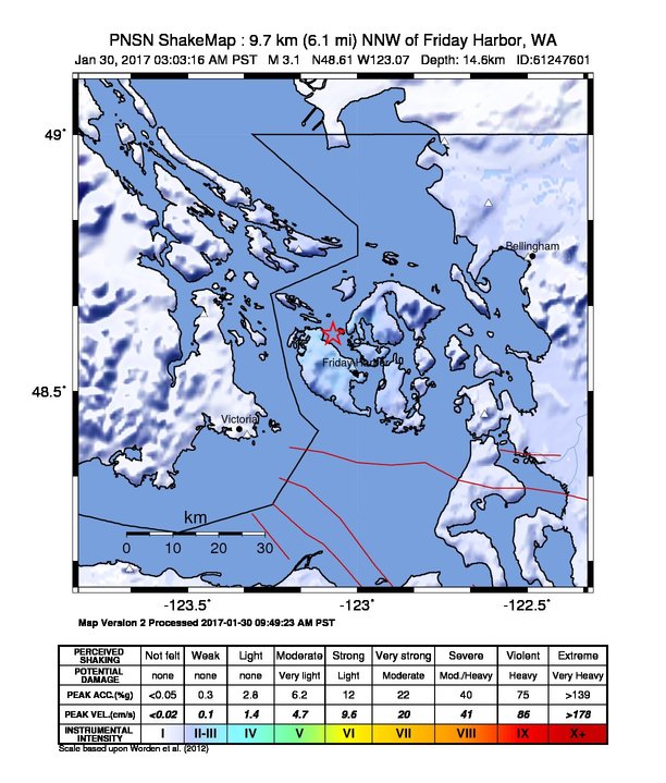
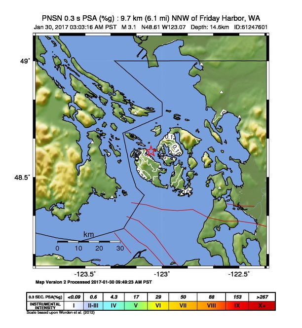
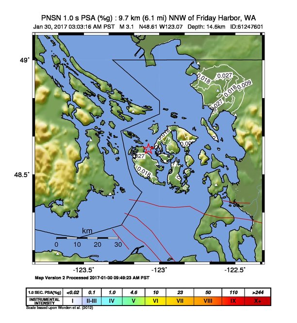
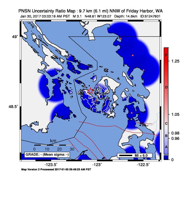
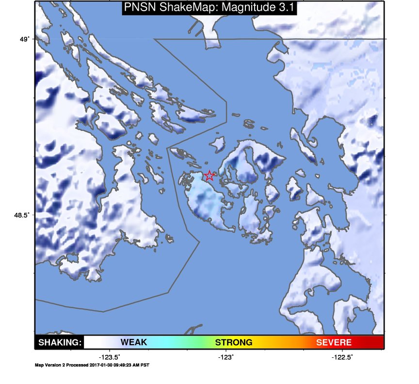
ShakeMap
Time:
Mon January 30, 2017 11:03:16 (UTC)
|
Depth:
14.59 km
|
Event ID:
61247601
|
Location:
48.611, -123.071


Downloads
| Regional | |
|---|---|
| intensity | JPG | PS.ZIP |
| acceleration | JPG | PS.ZIP |
| velocity | JPG | PS.ZIP |
| spectral 0.3 | JPG | PS.ZIP |
| spectral 1.0 | JPG | PS.ZIP |
| spectral 3.0 | JPG | PS.ZIP |
| uncertainty | JPG | PS.ZIP |
| tv map | JPG | PS.ZIP |
| tv map bare | JPG | PS.ZIP |
| tv info sheet | TXT |
| grid | XYZ.ZIP | XML.ZIP |
| gis | ZIP |
| station | TXT | XML |
| metadata | TXT |
Earthquake
| Event ID | Magnitude | Date | Time | Lat | Lon | Depth |
| 61247601 | 3.1 | // | :: | N48.61120 | W123.07120 | 14.59 km |
| Magnitude Bias: | MMI | PGA | PGV | PSA 0.3 | PSA 1.0 | PSA 3.0 |
| -1.23 | 0.09 | 0.27 | 0.07 | 0.37 | 0.96 |
Seismic Stations
| CN.PGC: | SIDNEY, BC | Agency: Canadian National Seismograph Network | |||
| Lat: 48.64980 Lon: -123.45210 Distance: 31.86 km from source | |||||
| Intensity: 1.0 | |||||
| Station Comp | Max Vel (cm/s) | Max Acc (%g) | PSA: 0.3 sec (%g) | 1.0 sec (%g) | 3.0 sec (%g) |
| --.BHE | 0.0066 | 0.0211 | 0.0355 | 0.0017 | 0.0001 -T |
| --.BHN | 0.0000 | 0.0000 | 0.0000 | 0.0000 | 0.0000 -T |
| CN.SNB: | SATURNA ISLAND, BC | Agency: Canadian National Seismograph Network | |||
| Lat: 48.77510 Lon: -123.17230 Distance: 24.50 km from source | |||||
| Intensity: 1.0 | |||||
| Station Comp | Max Vel (cm/s) | Max Acc (%g) | PSA: 0.3 sec (%g) | 1.0 sec (%g) | 3.0 sec (%g) |
| --.HHE | 0.0150 | 0.0597 | 0.0454 | 0.0029 | 0.0003 -T |
| --.HHN | 0.0056 | 0.0543 | 0.0167 | 0.0020 | 0.0001 -T |
| CN.VGZ: | Victoria Gonzales, BC | Agency: Canadian National Seismograph Network | |||
| Lat: 48.41390 Lon: -123.32440 Distance: 32.28 km from source | |||||
| Intensity: 1.0 | |||||
| Station Comp | Max Vel (cm/s) | Max Acc (%g) | PSA: 0.3 sec (%g) | 1.0 sec (%g) | 3.0 sec (%g) |
| --.HHE | 0.0028 | 0.0223 | 0.0065 | 0.0006 | 0.0001 -T |
| --.HHN | 0.0026 | 0.0333 | 0.0083 | 0.0006 | 0.0001 -T |
| UW.ERW: | Mt. Erie, WA, USA | Agency: Pacific Northwest Regional Seismic Network | |||
| Lat: 48.45400 Lon: -122.62506 Distance: 39.97 km from source | |||||
| Intensity: 1.0 | |||||
| Station Comp | Max Vel (cm/s) | Max Acc (%g) | PSA: 0.3 sec (%g) | 1.0 sec (%g) | 3.0 sec (%g) |
| --.ENN | 0.0078 | 0.0167 | 0.0156 | 0.0019 | 0.0010 |
| --.ENE | 0.0067 | 0.0220 | 0.0127 | 0.0015 | 0.0006 |
| UW.QHSH: | Henry St. Bellingham, WA | Agency: Pacific Northwest Regional Seismic Network | |||
| Lat: 48.76047 Lon: -122.49662 Distance: 47.62 km from source | |||||
| Intensity: 1.0 | |||||
| Station Comp | Max Vel (cm/s) | Max Acc (%g) | PSA: 0.3 sec (%g) | 1.0 sec (%g) | 3.0 sec (%g) |
| 01.HNN | 0.0049 | 0.0181 | 0.0542 | 0.0062 | 0.0022 |
| 01.HNE | 0.0041 | 0.0105 | 0.0173 | 0.0026 | 0.0016 |
| 01.HNZ | 0.0028 | 0.0102 | 0.0133 | 0.0016 | 0.0011 |
| UW.QJLF: | Peace Portal Dr. Blaine, WA | Agency: Pacific Northwest Regional Seismic Network | |||
| Lat: 48.98512 Lon: -122.74295 Distance: 50.20 km from source | |||||
| Intensity: 1.0 | |||||
| Station Comp | Max Vel (cm/s) | Max Acc (%g) | PSA: 0.3 sec (%g) | 1.0 sec (%g) | 3.0 sec (%g) |
| 01.HNN | 0.0046 | 0.0107 | 0.0171 | 0.0059 | 0.0013 |
| 01.HNE | 0.0070 | 0.0268 | 0.0244 | 0.0046 | 0.0017 |
| 01.HNZ | 0.0046 | 0.0102 | 0.0095 | 0.0020 | 0.0015 |
| UW.QRWC: | Tyler Ln. Ferndale, WA | Agency: Pacific Northwest Regional Seismic Network | |||
| Lat: 48.86541 Lon: -122.61349 Distance: 46.24 km from source | |||||
| Intensity: 2.0 | |||||
| Station Comp | Max Vel (cm/s) | Max Acc (%g) | PSA: 0.3 sec (%g) | 1.0 sec (%g) | 3.0 sec (%g) |
| 01.HNN | 0.0140 | 0.0079 | 0.0123 | 0.0086 | 0.0044 |
| 01.HNE | 0.0425 | 0.0186 | 0.0415 | 0.0399 | 0.0191 |
| 01.HNZ | 0.0025 | 0.0079 | 0.0070 | 0.0019 | 0.0014 |
| UW.STW: | Striped Peak | Agency: Pacific Northwest Seismic Network | |||
| Lat: 48.15067 Lon: -123.67106 Distance: 69.27 km from source | |||||
| Intensity: 1.0 | |||||
| Station Comp | Max Vel (cm/s) | Max Acc (%g) | PSA: 0.3 sec (%g) | 1.0 sec (%g) | 3.0 sec (%g) |
| --.ENN | 0.0040 | 0.0200 | 0.0080 | 0.0006 | 0.0002 |
| --.ENE | 0.0077 | 0.0255 | 0.0198 | 0.0011 | 0.0002 |
| UW.UWFH: | UW Friday Harbor ANSS-SMO | Agency: Pacific Northwest Regional Seismic Network | |||
| Lat: 48.54593 Lon: -123.01324 Distance: 16.84 km from source | |||||
| Intensity: 3.2 | |||||
| Station Comp | Max Vel (cm/s) | Max Acc (%g) | PSA: 0.3 sec (%g) | 1.0 sec (%g) | 3.0 sec (%g) |
| --.ENN | 0.2447 | 1.3668 | 0.3383 | 0.0205 | 0.0020 |
| --.ENE | 0.1704 | 1.3295 | 0.1995 | 0.0125 | 0.0021 |