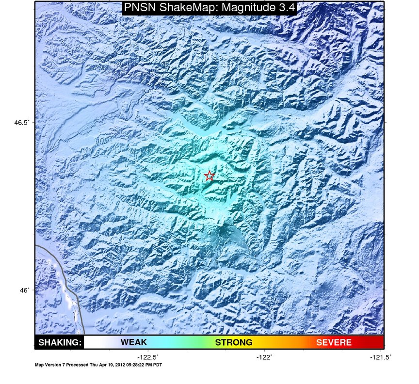
ShakeMap
Time:
Wed January 25, 2012 10:51:30 (UTC)
|
Depth:
7.62 km
|
Event ID:
60389576
|
Location:
46.34, -122.236

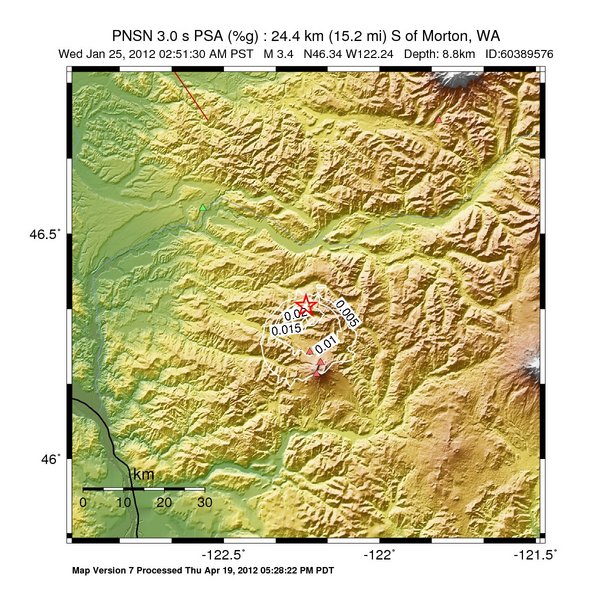
Pseudo Acceleration Spectra


Downloads
| Regional | |
|---|---|
| intensity | JPG | PS.ZIP |
| acceleration | JPG | PS.ZIP |
| velocity | JPG | PS.ZIP |
| spectral 0.3 | JPG | PS.ZIP |
| spectral 1.0 | JPG | PS.ZIP |
| spectral 3.0 | JPG | PS.ZIP |
| uncertainty | JPG | PS.ZIP |
| tv map | JPG | PS.ZIP |
| tv map bare | JPG | PS.ZIP |
| tv info sheet | TXT |
| grid | XYZ.ZIP | XML.ZIP |
| gis | ZIP |
| station | TXT | XML |
| metadata | TXT |
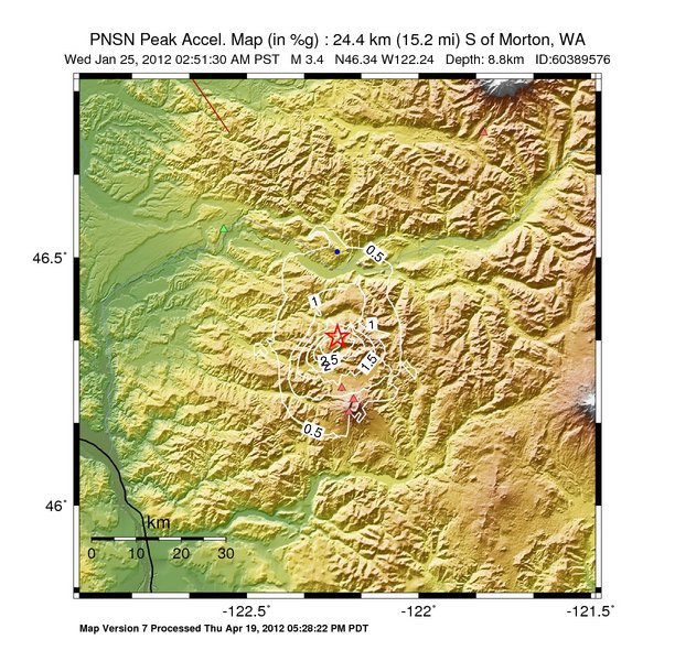
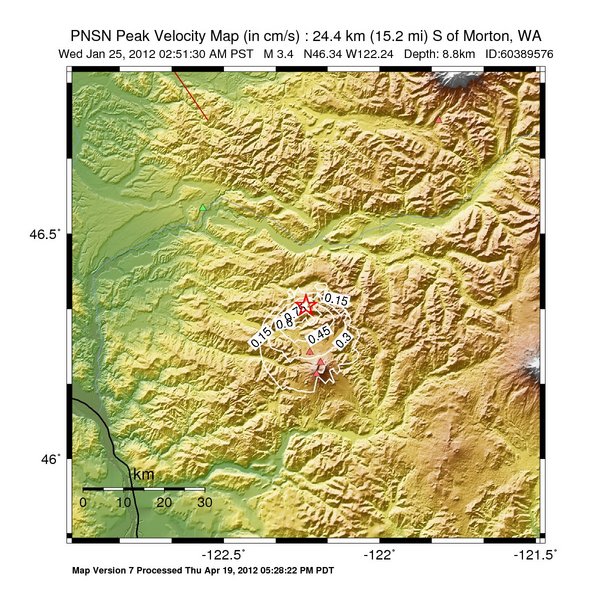
Earthquake
| Event ID | Magnitude | Date | Time | Lat | Lon | Depth |
| 60389576 | 3.4 | 1/25/2012 | 02:51:30 PST | N46.3402 | W122.2362 | 8.85 km |
| Magnitude Bias: | MMI | PGA | PGV | PSA 0.3 | PSA 1.0 | PSA 3.0 |
| 0.38 | 0.51 | 0.00 | 0.00 | 0.00 | 0.00 |
Seismic Stations
| 98356: | ZIP Code 98356 Morton (Intensity III, 4 responses) | Agency: USGS (Did You Feel It?) | |||
| Lat: 46.5117 Lon: -122.2366 Distance: 19.1 km from epicenter | |||||
| Intensity: 3.1 | |||||
| Station Comp | Max Vel (cm/s) | Max Acc (%g) | PSA: 0.3 sec (%g) | 1.0 sec (%g) | 3.0 sec (%g) |
| DERIVED | -- | 0.89 | -- | -- | -- |
| 98611: | ZIP Code 98611 Castle Rock (Intensity II, 3 responses) | Agency: USGS (Did You Feel It?) | |||
| Lat: 46.3042 Lon: -122.8862 Distance: 50.1 km from epicenter | |||||
| Intensity: 2.0 | |||||
| Station Comp | Max Vel (cm/s) | Max Acc (%g) | PSA: 0.3 sec (%g) | 1.0 sec (%g) | 3.0 sec (%g) |
| DERIVED | -- | -- | -- | -- | -- |
| CC.STD: | Studebaker Ridge, Mount St Helens, WA | Agency: Cascade Volcano Obervatory | |||
| Lat: 46.2376 Lon: -122.2240 Distance: 11.4 km from epicenter | |||||
| Intensity: 3.7 | |||||
| Station Comp | Max Vel (cm/s) | Max Acc (%g) | PSA: 0.3 sec (%g) | 1.0 sec (%g) | 3.0 sec (%g) |
| --.BHE | 0.5580 | 2.1507 | 2.9229 | 0.1292 | 0.0149 |
| --.BHN | 0.4040 | 1.8120 | 1.0410 | 0.0498 | 0.0059 |
| CC.SWFL: | Southwest Flank, Mt. St. Helens, WA | Agency: Cascade Volcano Obervatory | |||
| Lat: 46.1887 Lon: -122.2020 Distance: 17.1 km from epicenter | |||||
| Intensity: 3.0 | |||||
| Station Comp | Max Vel (cm/s) | Max Acc (%g) | PSA: 0.3 sec (%g) | 1.0 sec (%g) | 3.0 sec (%g) |
| --.BHE | 0.1346 | 0.3567 | 0.7994 | 0.0403 | 0.0037 |
| --.BHN | 0.1776 | 0.5060 | 0.8198 | 0.0519 | 0.0042 |
| CC.VALT: | Mt. St. Helens Crater, WA | Agency: Cascade Volcano Obervatory | |||
| Lat: 46.2142 Lon: -122.1893 Distance: 14.5 km from epicenter | |||||
| Intensity: 3.1 | |||||
| Station Comp | Max Vel (cm/s) | Max Acc (%g) | PSA: 0.3 sec (%g) | 1.0 sec (%g) | 3.0 sec (%g) |
| --.BHE | 0.2116 | 0.4912 | 0.9192 | 0.0515 | 0.0056 |
| --.BHN | 0.0959 | 0.2876 | 0.8894 | 0.0322 | 0.0027 |
| TA.E04D: | Cinebar, WA, USA | Agency: USArray Transportable Array | |||
| Lat: 46.5566 Lon: -122.5673 Distance: 35.0 km from epicenter | |||||
| Intensity: 1.5 | |||||
| Station Comp | Max Vel (cm/s) | Max Acc (%g) | PSA: 0.3 sec (%g) | 1.0 sec (%g) | 3.0 sec (%g) |
| --.BHE | 0.0279 | 0.1375 | 0.0413 | 0.0036 | 0.0003 |
| --.BHN | 0.0225 | 0.1417 | 0.0466 | 0.0043 | 0.0003 |
| UW.LON: | Longmire CREST broad-band | Agency: Pacific Northwest Regional Seismic Network | |||
| Lat: 46.7498 Lon: -121.8112 Distance: 56.0 km from epicenter | |||||
| Intensity: 1.0 | |||||
| Station Comp | Max Vel (cm/s) | Max Acc (%g) | PSA: 0.3 sec (%g) | 1.0 sec (%g) | 3.0 sec (%g) |
| --.BHE | 0.0028 | 0.0134 | 0.0064 | 0.0006 | 0.0001 |
| --.BHN | 0.0030 | 0.0176 | 0.0054 | 0.0007 | 0.0001 |