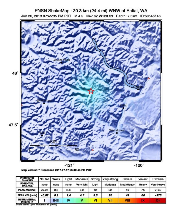
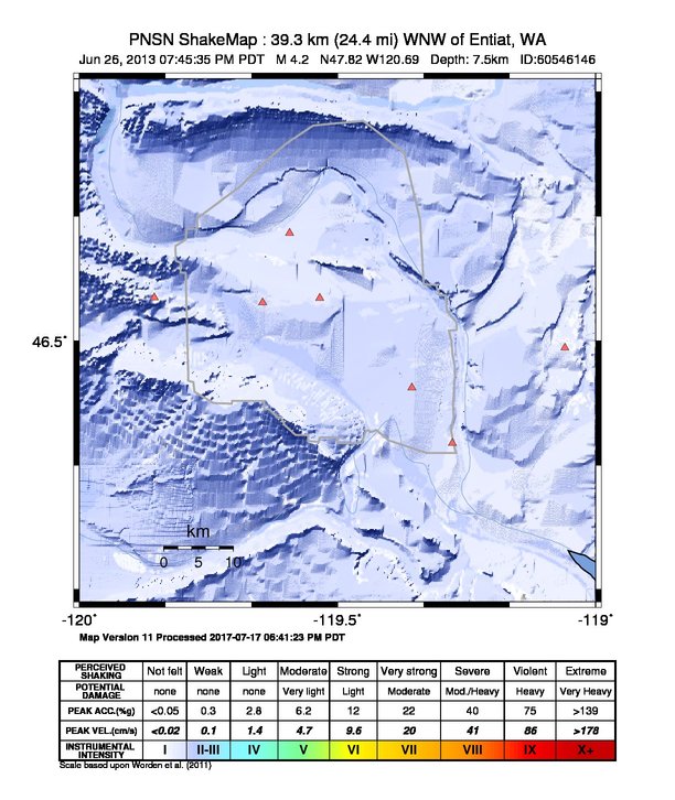
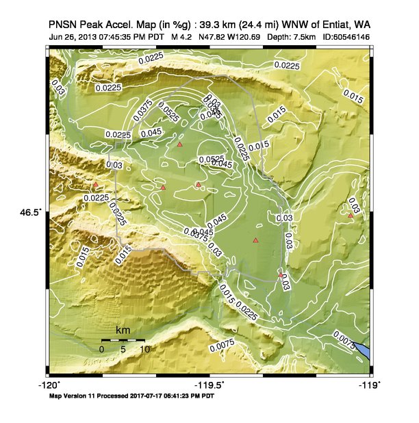
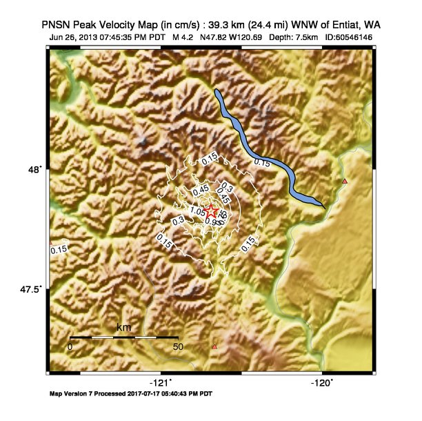
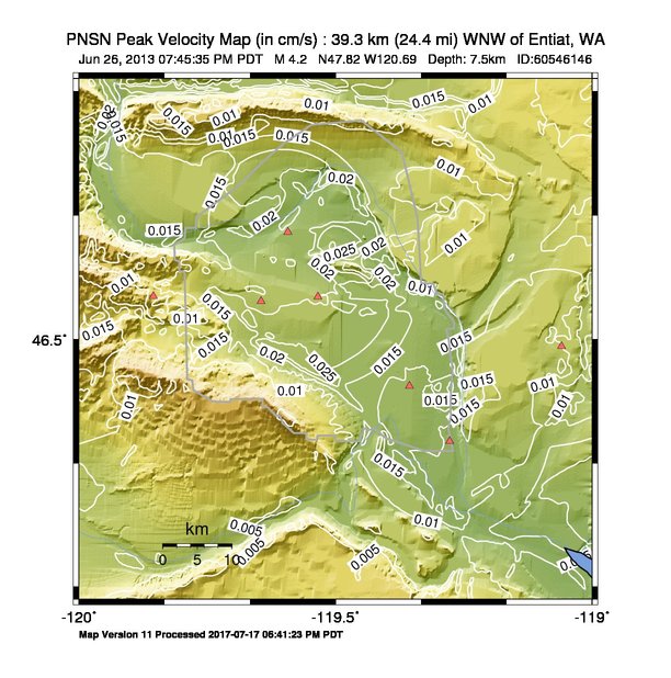
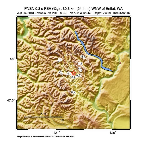
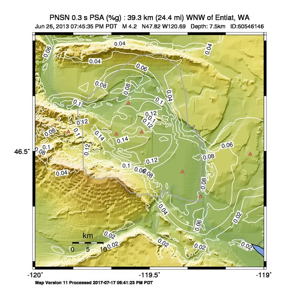
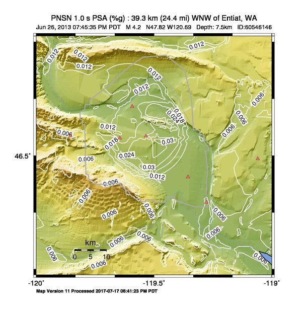
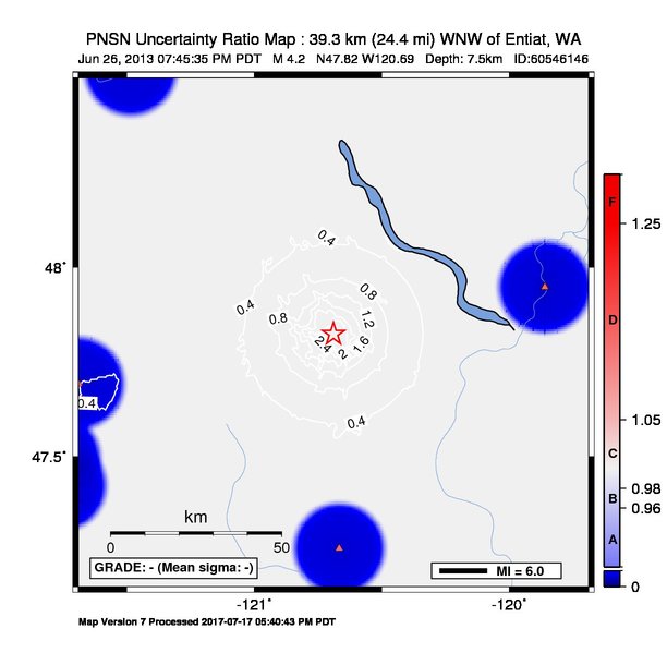
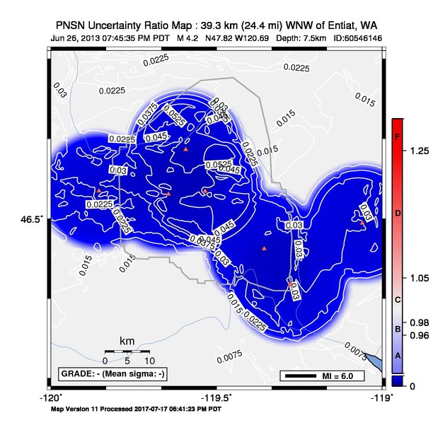
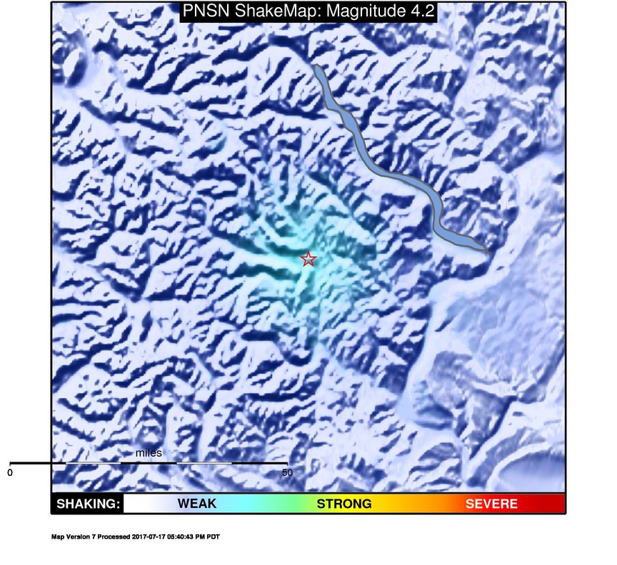
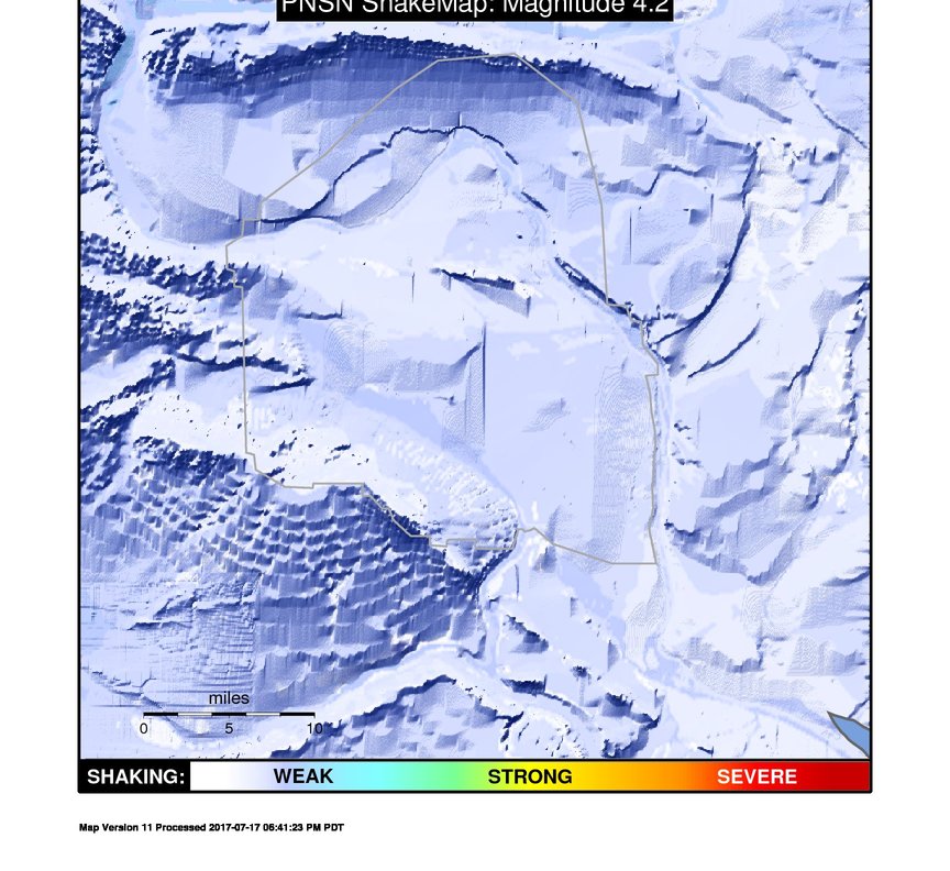
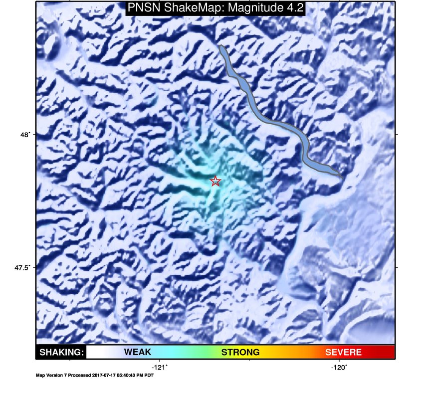
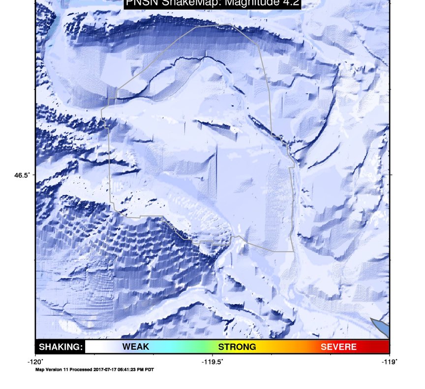
ShakeMap
Time:
Thu June 27, 2013 02:45:35 (UTC)
|
Depth:
7.51 km
|
Event ID:
60546146
|
Location:
47.824, -120.689

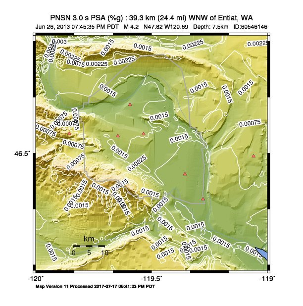
Pseudo Acceleration Spectra


Downloads
| Regional | High Resolution Hanford | |
|---|---|---|
| intensity | JPG | PS.ZIP | JPG | PS.ZIP |
| acceleration | JPG | PS.ZIP | JPG | PS.ZIP |
| velocity | JPG | PS.ZIP | JPG | PS.ZIP |
| spectral 0.3 | JPG | PS.ZIP | JPG | PS.ZIP |
| spectral 1.0 | JPG | PS.ZIP | JPG | PS.ZIP |
| spectral 3.0 | JPG | PS.ZIP | JPG | PS.ZIP |
| uncertainty | JPG | PS.ZIP | JPG | PS.ZIP |
| tv map | JPG | PS.ZIP | JPG | PS.ZIP |
| tv map bare | JPG | PS.ZIP | JPG | PS.ZIP |
| tv info sheet | TXT | TXT |
| grid | XYZ.ZIP | XML.ZIP | XYZ.ZIP | XML.ZIP |
| gis | ZIP | ZIP |
| station | TXT | XML | TXT | XML |
| metadata | TXT | TXT |
Earthquake
| Event ID | Magnitude | Date | Time | Lat | Lon | Depth |
| 60546146 | 4.2 | // | :: | N47.82420 | W120.68920 | 7.51 km |
| Magnitude Bias: | MMI | PGA | PGV | PSA 0.3 | PSA 1.0 | PSA 3.0 |
| -0.92 | 0.05 | -0.01 | 0.17 | -0.02 | -0.06 |
Seismic Stations
| UW.LTY: | Liberty BB CREST SMO | Agency: Pacific Northwest Regional Seismic Network | |||
| Lat: 47.25451 Lon: -120.66636 Distance: 63.81 km from source | |||||
| Intensity: 1.2 | |||||
| Station Comp | Max Vel (cm/s) | Max Acc (%g) | PSA: 0.3 sec (%g) | 1.0 sec (%g) | 3.0 sec (%g) |
| --.BHE | 0.0220 | 0.0744 | 0.1020 | 0.0080 | 0.0006 |
| --.BHN | 0.0166 | 0.0591 | 0.1056 | 0.0072 | 0.0010 |
| UW.TLW1: | Tolt Reservoir, Control House, WA | Agency: Pacific Northwest Regional Seismic Network | |||
| Lat: 47.69295 Lon: -121.68879 Distance: 76.50 km from source | |||||
| Intensity: 2.8 | |||||
| Station Comp | Max Vel (cm/s) | Max Acc (%g) | PSA: 0.3 sec (%g) | 1.0 sec (%g) | 3.0 sec (%g) |
| --.ENN | 0.1099 | 0.5626 | 0.3492 | 0.0195 | 0.0016 |
| --.ENE | 0.1677 | 0.5690 | 1.0808 | 0.0285 | 0.0030 |
| UW.WEL1: | Wells Dam, WA on earthfill | Agency: Pacific Northwest Regional Seismic Network | |||
| Lat: 47.94767 Lon: -119.86202 Distance: 63.64 km from source | |||||
| Intensity: 1.6 | |||||
| Station Comp | Max Vel (cm/s) | Max Acc (%g) | PSA: 0.3 sec (%g) | 1.0 sec (%g) | 3.0 sec (%g) |
| --.ENN | 0.0369 | 0.1910 | 0.2024 | 0.0096 | 0.0009 |
| --.ENE | 0.0369 | 0.2327 | 0.1816 | 0.0077 | 0.0008 |
| UW.WEL2: | Wells Dam abutment, WA | Agency: Pacific Northwest Regional Seismic Network | |||
| Lat: 47.94810 Lon: -119.85902 Distance: 63.86 km from source | |||||
| Intensity: 1.0 | |||||
| Station Comp | Max Vel (cm/s) | Max Acc (%g) | PSA: 0.3 sec (%g) | 1.0 sec (%g) | 3.0 sec (%g) |
| --.ENN | 0.0105 | 0.1292 | 0.0328 | 0.0026 | 0.0004 |
| --.ENE | 0.0099 | 0.1045 | 0.0293 | 0.0035 | 0.0003 |
Earthquake
| Event ID | Magnitude | Date | Time | Lat | Lon | Depth |
| 60546146 | 4.2 | // | :: | N47.82420 | W120.68920 | 7.51 km |
| Magnitude Bias: | MMI | PGA | PGV | PSA 0.3 | PSA 1.0 | PSA 3.0 |
| 0.00 | 0.00 | 0.00 | 0.00 | 0.00 | 0.00 |
Seismic Stations
| UW.CCRK: | Sunnyside, WA, USA | Agency: Pacific Northwest Regional Seismic Network | |||
| Lat: 46.55850 Lon: -119.85480 Distance: 154.40 km from epicenter | |||||
| Intensity: 1.0 | |||||
| Station Comp | Max Vel (cm/s) | Max Acc (%g) | PSA: 0.3 sec (%g) | 1.0 sec (%g) | 3.0 sec (%g) |
| --.HHE | 0.0141 | 0.0290 | 0.1325 | 0.0086 | 0.0006 |
| --.HHN | 0.0143 | 0.0301 | 0.0924 | 0.0081 | 0.0005 |
| UW.DDRF: | Dider Farm, Eltopia, WA, USA | Agency: Pacific Northwest Seismic Network | |||
| Lat: 46.49110 Lon: -119.05950 Distance: 192.90 km from epicenter | |||||
| Intensity: 1.0 | |||||
| Station Comp | Max Vel (cm/s) | Max Acc (%g) | PSA: 0.3 sec (%g) | 1.0 sec (%g) | 3.0 sec (%g) |
| --.BHE | 0.0110 | 0.0356 | 0.0648 | 0.0033 | 0.0003 |
| --.BHN | 0.0064 | 0.0240 | 0.0445 | 0.0024 | 0.0002 |
| UW.H1K: | 100 K Area, Hanford, WA, USA | Agency: Pacific Northwest Regional Seismic Network | |||
| Lat: 46.64468 Lon: -119.59287 Distance: 155.27 km from epicenter | |||||
| Intensity: 1.1 | |||||
| Station Comp | Max Vel (cm/s) | Max Acc (%g) | PSA: 0.3 sec (%g) | 1.0 sec (%g) | 3.0 sec (%g) |
| --.HNN | 0.0123 | 0.0276 | 0.0946 | 0.0069 | 0.0007 |
| --.HNE | 0.0198 | 0.0536 | 0.0842 | 0.0110 | 0.0009 |
| UW.H2E: | 200 East Area, Hanford, WA, USA | Agency: Pacific Northwest Regional Seismic Network | |||
| Lat: 46.55780 Lon: -119.53450 Distance: 165.82 km from epicenter | |||||
| Intensity: 1.3 | |||||
| Station Comp | Max Vel (cm/s) | Max Acc (%g) | PSA: 0.3 sec (%g) | 1.0 sec (%g) | 3.0 sec (%g) |
| --.HNN | 0.0193 | 0.0628 | 0.1701 | 0.0070 | 0.0009 |
| --.HNE | 0.0251 | 0.0584 | 0.1514 | 0.0378 | 0.0016 |
| UW.H2W: | 200 West Area, Hanford, WA, USA | Agency: Pacific Northwest Regional Seismic Network | |||
| Lat: 46.55170 Lon: -119.64532 Distance: 162.17 km from epicenter | |||||
| Intensity: 1.0 | |||||
| Station Comp | Max Vel (cm/s) | Max Acc (%g) | PSA: 0.3 sec (%g) | 1.0 sec (%g) | 3.0 sec (%g) |
| --.HNN | 0.0122 | 0.0218 | 0.0702 | 0.0079 | 0.0008 |
| --.HNE | 0.0170 | 0.0329 | 0.1696 | 0.0061 | 0.0009 |
| UW.H3A: | 300 Area, Hanford, WA, USA | Agency: Pacific Northwest Regional Seismic Network | |||
| Lat: 46.36322 Lon: -119.27747 Distance: 194.59 km from epicenter | |||||
| Intensity: 1.0 | |||||
| Station Comp | Max Vel (cm/s) | Max Acc (%g) | PSA: 0.3 sec (%g) | 1.0 sec (%g) | 3.0 sec (%g) |
| --.HNN | 0.0114 | 0.0257 | 0.0680 | 0.0037 | 0.0009 |
| --.HNE | 0.0137 | 0.0350 | 0.0844 | 0.0051 | 0.0010 |
| UW.H4A: | 400 Area, Hanford, WA, USA | Agency: Pacific Northwest Regional Seismic Network | |||
| Lat: 46.43774 Lon: -119.35567 Distance: 184.39 km from epicenter | |||||
| Intensity: 1.0 | |||||
| Station Comp | Max Vel (cm/s) | Max Acc (%g) | PSA: 0.3 sec (%g) | 1.0 sec (%g) | 3.0 sec (%g) |
| --.HNN | 0.0132 | 0.0302 | 0.0738 | 0.0096 | 0.0008 |
| --.HNE | 0.0161 | 0.0381 | 0.1200 | 0.0093 | 0.0012 |