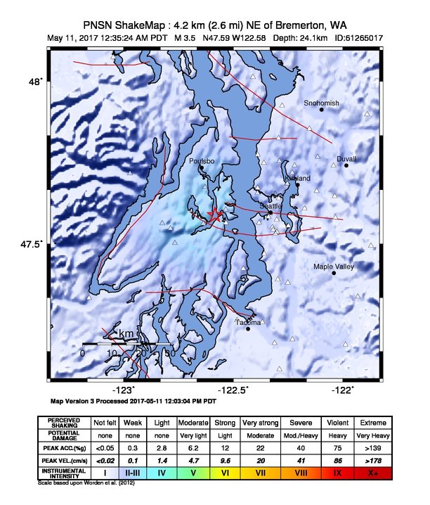
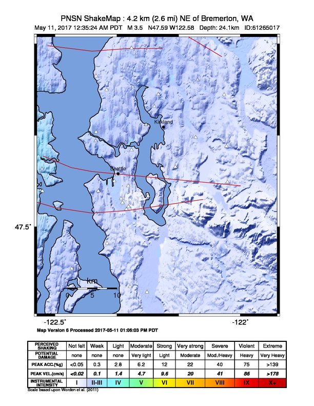
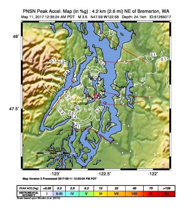
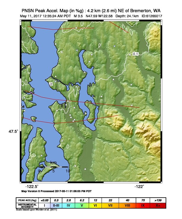
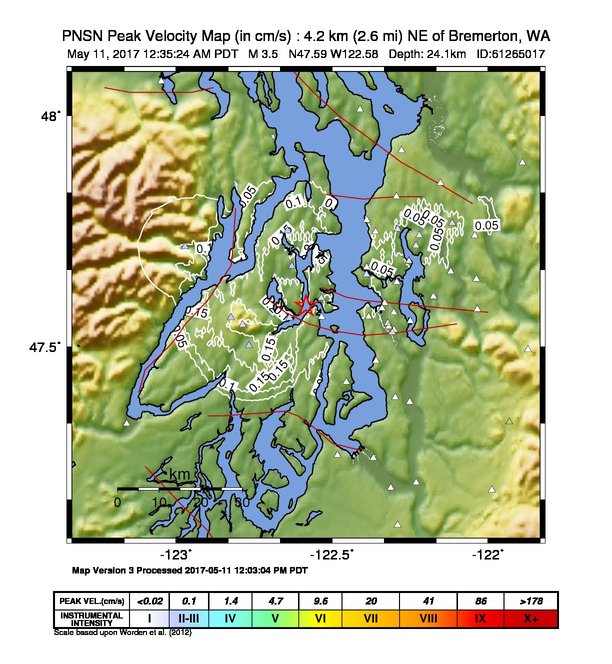
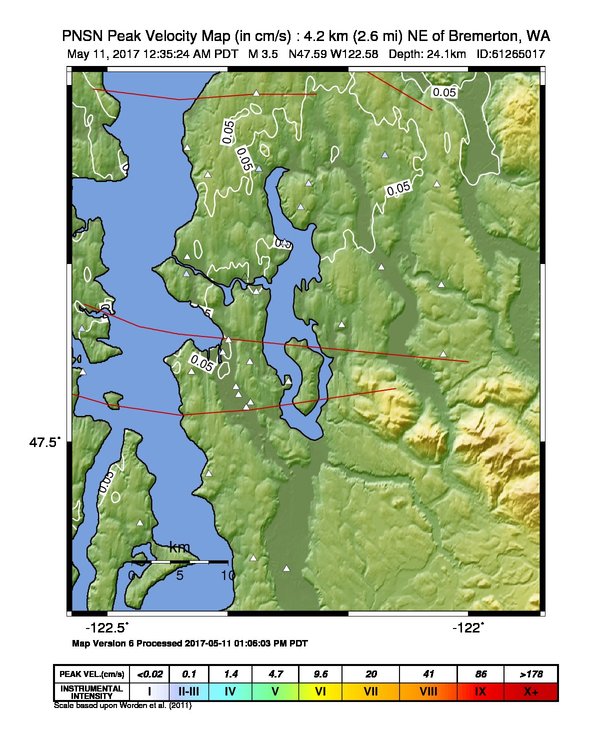
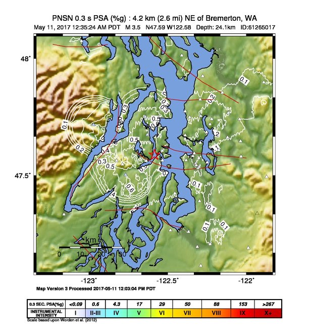
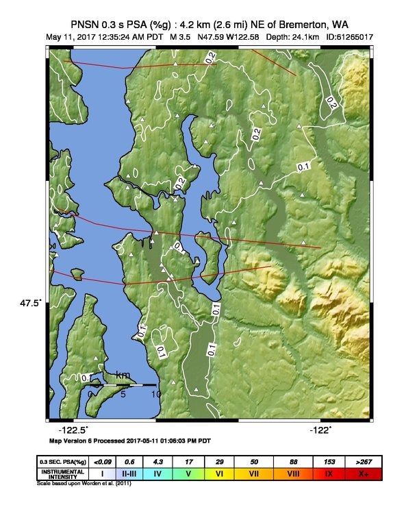
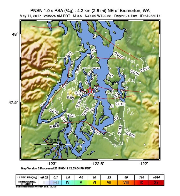
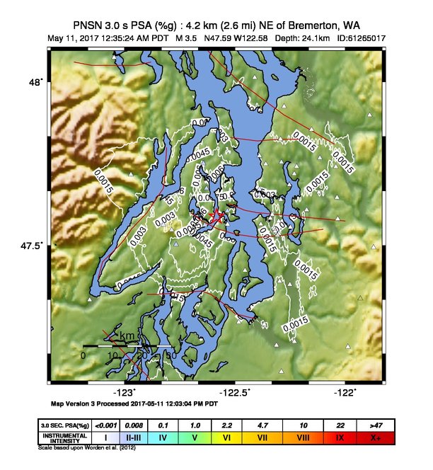
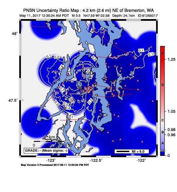
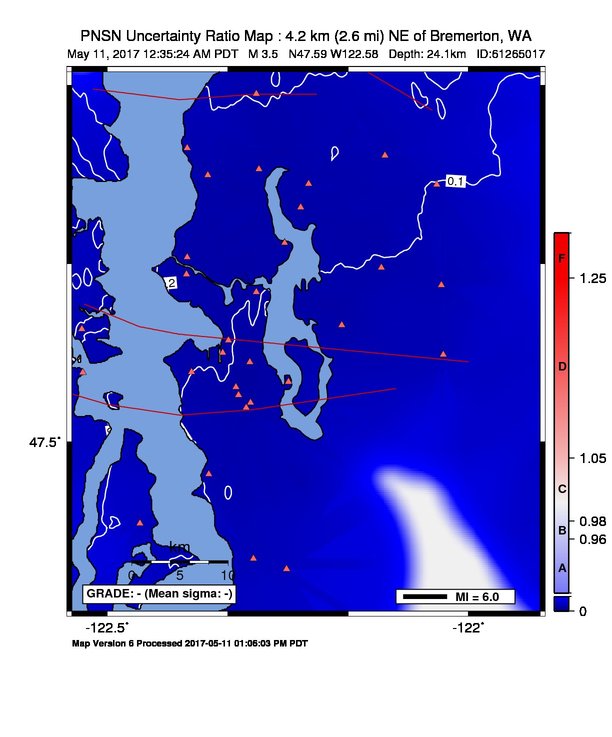
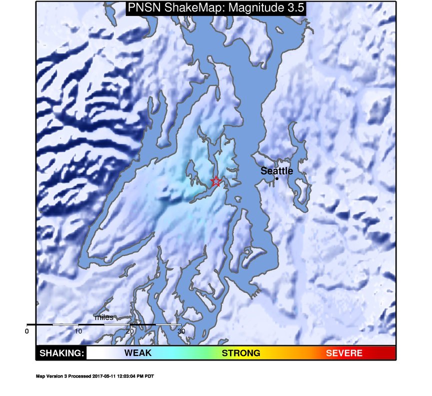
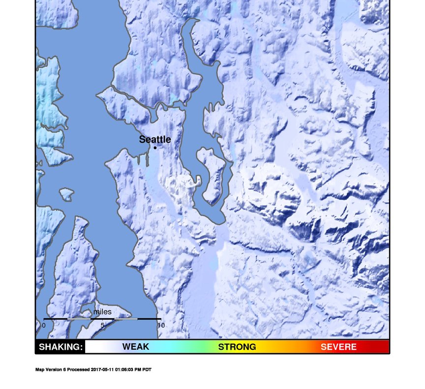
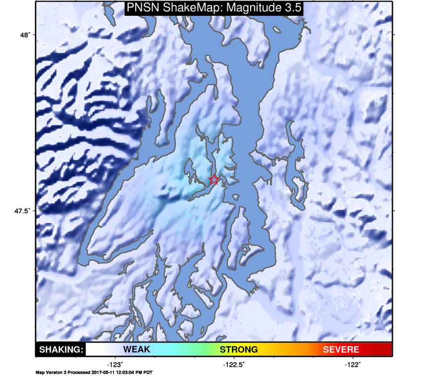
ShakeMap
Time:
Thu May 11, 2017 07:35:24 (UTC)
|
Depth:
24.06 km
|
Event ID:
61265017
|
Location:
47.589, -122.584


Downloads
| Regional | High Resolution Seattle | |
|---|---|---|
| intensity | JPG | PS.ZIP | JPG | PS.ZIP |
| acceleration | JPG | PS.ZIP | JPG | PS.ZIP |
| velocity | JPG | PS.ZIP | JPG | PS.ZIP |
| spectral 0.3 | JPG | PS.ZIP | JPG | PS.ZIP |
| spectral 1.0 | JPG | PS.ZIP | JPG | PS.ZIP |
| spectral 3.0 | JPG | PS.ZIP | JPG | PS.ZIP |
| uncertainty | JPG | PS.ZIP | JPG | PS.ZIP |
| tv map | JPG | PS.ZIP | JPG | PS.ZIP |
| tv map bare | JPG | PS.ZIP | JPG | PS.ZIP |
| tv info sheet | TXT | TXT |
| grid | XYZ.ZIP | XML.ZIP | XYZ.ZIP | XML.ZIP |
| gis | ZIP | ZIP |
| station | TXT | XML | TXT | XML |
| metadata | TXT | TXT |
Earthquake
| Event ID | Magnitude | Date | Time | Lat | Lon | Depth |
| 61265017 | 3.5 | // | :: | N47.58870 | W122.58420 | 24.06 km |
| Magnitude Bias: | MMI | PGA | PGV | PSA 0.3 | PSA 1.0 | PSA 3.0 |
| -1.23 | -0.05 | 0.00 | 0.02 | 0.30 | 0.14 |
Seismic Stations
| UW.ALCT: | Alcott School, Redmond ANSS-SMO | Agency: Pacific Northwest Regional Seismic Network | |||
| Lat: 47.64690 Lon: -122.03770 Distance: 47.94 km from source | |||||
| Intensity: 1.0 | |||||
| Station Comp | Max Vel (cm/s) | Max Acc (%g) | PSA: 0.3 sec (%g) | 1.0 sec (%g) | 3.0 sec (%g) |
| --.ENN | 0.0142 | 0.0292 | 0.0358 | 0.0098 | 0.0008 |
| --.ENE | 0.0107 | 0.0313 | 0.0384 | 0.0116 | 0.0008 |
| UW.BABE: | Bainbridge School ANSS-SMO | Agency: Pacific Northwest Regional Seismic Network | |||
| Lat: 47.60583 Lon: -122.53528 Distance: 24.41 km from source | |||||
| Intensity: 2.6 | |||||
| Station Comp | Max Vel (cm/s) | Max Acc (%g) | PSA: 0.3 sec (%g) | 1.0 sec (%g) | 3.0 sec (%g) |
| --.ENN | 0.0793 | 0.2637 | 0.3740 | 0.0308 | 0.0031 |
| --.ENE | 0.1080 | 0.3195 | 0.5036 | 0.0560 | 0.0051 |
| UW.BEVT: | Boeing Everett ANSS-SMO | Agency: Pacific Northwest Regional Seismic Network | |||
| Lat: 47.92497 Lon: -122.27811 Distance: 50.01 km from source | |||||
| Intensity: 1.0 | |||||
| Station Comp | Max Vel (cm/s) | Max Acc (%g) | PSA: 0.3 sec (%g) | 1.0 sec (%g) | 3.0 sec (%g) |
| --.ENN | 0.0091 | 0.0240 | 0.0385 | 0.0038 | 0.0009 |
| --.ENE | 0.0082 | 0.0313 | 0.0303 | 0.0049 | 0.0006 |
| UW.BRKS: | Brookside ANSS-SMO | Agency: Pacific Northwest Regional Seismic Network | |||
| Lat: 47.75520 Lon: -122.29013 Distance: 37.50 km from source | |||||
| Intensity: 2.6 | |||||
| Station Comp | Max Vel (cm/s) | Max Acc (%g) | PSA: 0.3 sec (%g) | 1.0 sec (%g) | 3.0 sec (%g) |
| --.ENN | 0.0987 | 0.2869 | 0.4696 | 0.0387 | 0.0034 |
| --.ENE | 0.0623 | 0.1710 | 0.2329 | 0.0323 | 0.0029 |
| UW.BSFP: | Boeing Fire Protection | Agency: Pacific Northwest Regional Seismic Network | |||
| Lat: 47.53186 Lon: -122.30777 Distance: 32.39 km from source | |||||
| Intensity: 1.3 | |||||
| Station Comp | Max Vel (cm/s) | Max Acc (%g) | PSA: 0.3 sec (%g) | 1.0 sec (%g) | 3.0 sec (%g) |
| --.ENN | 0.0233 | 0.0468 | 0.1411 | 0.0320 | 0.0021 |
| --.ENE | 0.0186 | 0.0474 | 0.1063 | 0.0245 | 0.0014 |
| UW.DOSE: | Dosewallips old TA.C04A, WA | Agency: Pacific Northwest Regional Seismic Network | |||
| Lat: 47.71720 Lon: -122.97180 Distance: 40.32 km from source | |||||
| Intensity: 2.8 | |||||
| Station Comp | Max Vel (cm/s) | Max Acc (%g) | PSA: 0.3 sec (%g) | 1.0 sec (%g) | 3.0 sec (%g) |
| --.BHE | 0.1491 | 0.5244 | 0.9809 | 0.0256 | 0.0029 |
| --.BHN | 0.0980 | 0.4735 | 0.5122 | 0.0139 | 0.0013 |
| UW.EARN: | East Ridge ES ANSS-SMO | Agency: Pacific Northwest Regional Seismic Network | |||
| Lat: 47.74090 Lon: -122.04380 Distance: 50.03 km from source | |||||
| Intensity: 1.4 | |||||
| Station Comp | Max Vel (cm/s) | Max Acc (%g) | PSA: 0.3 sec (%g) | 1.0 sec (%g) | 3.0 sec (%g) |
| --.ENN | 0.0236 | 0.0751 | 0.0738 | 0.0130 | 0.0010 |
| --.ENE | 0.0113 | 0.0285 | 0.0552 | 0.0059 | 0.0005 |
| UW.ELW: | EchoLakeBPA | Agency: Pacific Northwest Regional Seismic Network | |||
| Lat: 47.49410 Lon: -121.87267 Distance: 59.52 km from source | |||||
| Intensity: 1.0 | |||||
| Station Comp | Max Vel (cm/s) | Max Acc (%g) | PSA: 0.3 sec (%g) | 1.0 sec (%g) | 3.0 sec (%g) |
| --.ENN | 0.0032 | 0.0123 | 0.0176 | 0.0018 | 0.0003 |
| --.ENE | 0.0049 | 0.0184 | 0.0098 | 0.0020 | 0.0004 |
| UW.EVGW: | Everett Gateway Middle School ANSS-SMO | Agency: Pacific Northwest Regional Seismic Network | |||
| Lat: 47.85440 Lon: -122.15338 Distance: 49.90 km from source | |||||
| Intensity: 1.4 | |||||
| Station Comp | Max Vel (cm/s) | Max Acc (%g) | PSA: 0.3 sec (%g) | 1.0 sec (%g) | 3.0 sec (%g) |
| --.ENN | 0.0246 | 0.0574 | 0.1030 | 0.0093 | 0.0009 |
| --.ENE | 0.0119 | 0.0398 | 0.0480 | 0.0056 | 0.0004 |
| UW.FINN: | Finn Hill Jr High ANSS-SMO | Agency: Pacific Northwest Regional Seismic Network | |||
| Lat: 47.71950 Lon: -122.23220 Distance: 38.54 km from source | |||||
| Intensity: 2.3 | |||||
| Station Comp | Max Vel (cm/s) | Max Acc (%g) | PSA: 0.3 sec (%g) | 1.0 sec (%g) | 3.0 sec (%g) |
| --.ENN | 0.0692 | 0.1800 | 0.3001 | 0.0266 | 0.0026 |
| --.ENE | 0.0146 | 0.0497 | 0.0681 | 0.0076 | 0.0010 |
| UW.GMW: | Gold Mt. | Agency: Pacific Northwest Regional Seismic Network | |||
| Lat: 47.54773 Lon: -122.78759 Distance: 28.85 km from source | |||||
| Intensity: 2.5 | |||||
| Station Comp | Max Vel (cm/s) | Max Acc (%g) | PSA: 0.3 sec (%g) | 1.0 sec (%g) | 3.0 sec (%g) |
| --.ENN | 0.0925 | 0.3903 | 0.2965 | 0.0249 | 0.0028 |
| --.ENE | 0.0765 | 0.4309 | 0.2227 | 0.0145 | 0.0015 |
| UW.GNW: | Green Mountain (BB) CREST SMO | Agency: Pacific Northwest Regional Seismic Network | |||
| Lat: 47.56413 Lon: -122.82498 Distance: 30.21 km from source | |||||
| Intensity: 3.0 | |||||
| Station Comp | Max Vel (cm/s) | Max Acc (%g) | PSA: 0.3 sec (%g) | 1.0 sec (%g) | 3.0 sec (%g) |
| --.BHE | 0.1796 | 0.8884 | 0.4295 | 0.0259 | 0.0028 |
| --.BHN | 0.1384 | 0.5621 | 0.4976 | 0.0257 | 0.0025 |
| UW.GTWN: | Georgetown Playfield ANSS-SMO | Agency: Pacific Northwest Regional Seismic Network | |||
| Lat: 47.55121 Lon: -122.32201 Distance: 31.36 km from source | |||||
| Intensity: 1.1 | |||||
| Station Comp | Max Vel (cm/s) | Max Acc (%g) | PSA: 0.3 sec (%g) | 1.0 sec (%g) | 3.0 sec (%g) |
| --.ENN | 0.0178 | 0.0372 | 0.0986 | 0.0286 | 0.0013 |
| --.ENE | 0.0176 | 0.0266 | 0.0930 | 0.0195 | 0.0010 |
| UW.HICC: | Highline CC ANSS-SMO | Agency: Pacific Northwest Regional Seismic Network | |||
| Lat: 47.39012 Lon: -122.29790 Distance: 39.11 km from source | |||||
| Intensity: 1.0 | |||||
| Station Comp | Max Vel (cm/s) | Max Acc (%g) | PSA: 0.3 sec (%g) | 1.0 sec (%g) | 3.0 sec (%g) |
| --.ENN | 0.0075 | 0.0144 | 0.0240 | 0.0075 | 0.0007 |
| --.ENE | 0.0132 | 0.0175 | 0.0299 | 0.0088 | 0.0011 |
| UW.HOLY: | Holy Rosary ANSS-SMO | Agency: Pacific Northwest Regional Seismic Network | |||
| Lat: 47.56540 Lon: -122.38360 Distance: 28.50 km from source | |||||
| Intensity: 1.6 | |||||
| Station Comp | Max Vel (cm/s) | Max Acc (%g) | PSA: 0.3 sec (%g) | 1.0 sec (%g) | 3.0 sec (%g) |
| --.ENN | 0.0207 | 0.0427 | 0.1205 | 0.0257 | 0.0011 |
| --.ENE | 0.0305 | 0.0485 | 0.1290 | 0.0326 | 0.0018 |
| UW.KCAM: | King County Airport Maint. Shop, ANSS-SMO | Agency: Pacific Northwest Regional Seismic Network | |||
| Lat: 47.54400 Lon: -122.31850 Distance: 31.64 km from source | |||||
| Intensity: 1.1 | |||||
| Station Comp | Max Vel (cm/s) | Max Acc (%g) | PSA: 0.3 sec (%g) | 1.0 sec (%g) | 3.0 sec (%g) |
| --.ENN | 0.0187 | 0.0324 | 0.0499 | 0.0370 | 0.0015 |
| --.ENE | 0.0141 | 0.0225 | 0.0425 | 0.0149 | 0.0013 |
| UW.KDK: | Coastal Environmental, Seattle ANSS-SMO | Agency: Pacific Northwest Regional Seismic Network | |||
| Lat: 47.59520 Lon: -122.33223 Distance: 30.60 km from source | |||||
| Intensity: 2.0 | |||||
| Station Comp | Max Vel (cm/s) | Max Acc (%g) | PSA: 0.3 sec (%g) | 1.0 sec (%g) | 3.0 sec (%g) |
| --.ENN | 0.0200 | 0.0559 | 0.1136 | 0.0126 | 0.0016 |
| --.ENE | 0.0458 | 0.0882 | 0.1468 | 0.0215 | 0.0021 |
| UW.KIMB: | Kimball School ANSS-SMO | Agency: Pacific Northwest Regional Seismic Network | |||
| Lat: 47.57480 Lon: -122.30280 Distance: 32.04 km from source | |||||
| Intensity: 1.0 | |||||
| Station Comp | Max Vel (cm/s) | Max Acc (%g) | PSA: 0.3 sec (%g) | 1.0 sec (%g) | 3.0 sec (%g) |
| --.ENN | 0.0081 | 0.0111 | 0.0349 | 0.0058 | 0.0009 |
| --.ENE | 0.0122 | 0.0171 | 0.0553 | 0.0123 | 0.0011 |
| UW.KIMR: | Kitsap Mod Risk ANSS-SMO | Agency: Pacific Northwest Regional Seismic Network | |||
| Lat: 47.50306 Lon: -122.76722 Distance: 29.30 km from source | |||||
| Intensity: 3.0 | |||||
| Station Comp | Max Vel (cm/s) | Max Acc (%g) | PSA: 0.3 sec (%g) | 1.0 sec (%g) | 3.0 sec (%g) |
| --.ENN | 0.2109 | 0.6528 | 0.9620 | 0.0521 | 0.0064 |
| --.ENE | 0.1420 | 0.4923 | 0.4840 | 0.0317 | 0.0030 |
| UW.KINR: | Kitsap Road Shed ANSS-SMO | Agency: Pacific Northwest Regional Seismic Network | |||
| Lat: 47.75167 Lon: -122.64306 Distance: 30.44 km from source | |||||
| Intensity: 3.0 | |||||
| Station Comp | Max Vel (cm/s) | Max Acc (%g) | PSA: 0.3 sec (%g) | 1.0 sec (%g) | 3.0 sec (%g) |
| --.ENN | 0.1960 | 0.4385 | 0.6704 | 0.0607 | 0.0069 |
| --.ENE | 0.0856 | 0.2302 | 0.3227 | 0.0211 | 0.0021 |
| UW.KITP: | Kitsap Treatment Plant ANSS-SMO | Agency: Pacific Northwest Regional Seismic Network | |||
| Lat: 47.67520 Lon: -122.62974 Distance: 26.14 km from source | |||||
| Intensity: 3.1 | |||||
| Station Comp | Max Vel (cm/s) | Max Acc (%g) | PSA: 0.3 sec (%g) | 1.0 sec (%g) | 3.0 sec (%g) |
| --.ENN | 0.2157 | 0.9430 | 0.6984 | 0.0611 | 0.0070 |
| --.ENE | 0.1091 | 0.3428 | 0.3906 | 0.0219 | 0.0022 |
| UW.KNEL: | Kent Elementary ANSS-SMO | Agency: Pacific Northwest Regional Seismic Network | |||
| Lat: 47.38052 Lon: -122.25193 Distance: 41.69 km from source | |||||
| Intensity: 1.8 | |||||
| Station Comp | Max Vel (cm/s) | Max Acc (%g) | PSA: 0.3 sec (%g) | 1.0 sec (%g) | 3.0 sec (%g) |
| --.ENN | 0.0305 | 0.0700 | 0.1131 | 0.0187 | 0.0016 |
| --.ENE | 0.0395 | 0.0667 | 0.1502 | 0.0209 | 0.0023 |
| UW.LAWT: | Lawton School ANSS-SMO | Agency: Pacific Northwest Regional Seismic Network | |||
| Lat: 47.65694 Lon: -122.39062 Distance: 29.10 km from source | |||||
| Intensity: 2.5 | |||||
| Station Comp | Max Vel (cm/s) | Max Acc (%g) | PSA: 0.3 sec (%g) | 1.0 sec (%g) | 3.0 sec (%g) |
| --.ENN | 0.0733 | 0.2269 | 0.2416 | 0.0237 | 0.0029 |
| --.ENE | 0.0934 | 0.3653 | 0.3387 | 0.0335 | 0.0039 |
| UW.LEOT: | Leota J. High ANSS-SMO | Agency: Pacific Northwest Regional Seismic Network | |||
| Lat: 47.76790 Lon: -122.11560 Distance: 46.98 km from source | |||||
| Intensity: 2.6 | |||||
| Station Comp | Max Vel (cm/s) | Max Acc (%g) | PSA: 0.3 sec (%g) | 1.0 sec (%g) | 3.0 sec (%g) |
| --.ENN | 0.1127 | 0.2839 | 0.4277 | 0.0240 | 0.0032 |
| --.ENE | 0.0597 | 0.1934 | 0.2450 | 0.0125 | 0.0011 |
| UW.LYNC: | Lynnwood City Hall, ANSS-SMO | Agency: Pacific Northwest Regional Seismic Network | |||
| Lat: 47.82555 Lon: -122.29384 Distance: 41.77 km from source | |||||
| Intensity: 1.0 | |||||
| Station Comp | Max Vel (cm/s) | Max Acc (%g) | PSA: 0.3 sec (%g) | 1.0 sec (%g) | 3.0 sec (%g) |
| --.ENN | 0.0095 | 0.0282 | 0.0291 | 0.0111 | 0.0008 |
| --.ENE | 0.0098 | 0.0156 | 0.0405 | 0.0126 | 0.0008 |
| UW.MARY: | Marymoor Park ANSS-SMO | Agency: Pacific Northwest Regional Seismic Network | |||
| Lat: 47.66334 Lon: -122.12068 Distance: 43.06 km from source | |||||
| Intensity: 1.4 | |||||
| Station Comp | Max Vel (cm/s) | Max Acc (%g) | PSA: 0.3 sec (%g) | 1.0 sec (%g) | 3.0 sec (%g) |
| --.ENN | 0.0247 | 0.0355 | 0.0652 | 0.0186 | 0.0014 |
| --.ENE | 0.0099 | 0.0254 | 0.0529 | 0.0099 | 0.0008 |
| UW.MBPA: | Monroe BPA, WA, USA | Agency: Pacific Northwest Regional Seismic Network | |||
| Lat: 47.89835 Lon: -121.89018 Distance: 66.76 km from source | |||||
| Intensity: 1.5 | |||||
| Station Comp | Max Vel (cm/s) | Max Acc (%g) | PSA: 0.3 sec (%g) | 1.0 sec (%g) | 3.0 sec (%g) |
| --.ENN | 0.0245 | 0.0796 | 0.1391 | 0.0064 | 0.0007 |
| --.ENE | 0.0263 | 0.1090 | 0.0675 | 0.0039 | 0.0006 |
| UW.MNWA: | Manchester, WA | Agency: Pacific Northwest Regional Seismic Network | |||
| Lat: 47.56503 Lon: -122.53414 Distance: 24.49 km from source | |||||
| Intensity: 1.9 | |||||
| Station Comp | Max Vel (cm/s) | Max Acc (%g) | PSA: 0.3 sec (%g) | 1.0 sec (%g) | 3.0 sec (%g) |
| --.ENN | 0.0275 | 0.2207 | 0.0748 | 0.0225 | 0.0020 |
| --.ENE | 0.0411 | 0.1775 | 0.1152 | 0.0157 | 0.0011 |
| UW.MPL: | Maple Valley SMO | Agency: Pacific Northwest Regional Seismic Network | |||
| Lat: 47.68630 Lon: -122.25444 Distance: 36.15 km from source | |||||
| Intensity: 1.0 | |||||
| Station Comp | Max Vel (cm/s) | Max Acc (%g) | PSA: 0.3 sec (%g) | 1.0 sec (%g) | 3.0 sec (%g) |
| --.ENN | 0.0058 | 0.0123 | 0.0353 | 0.0039 | 0.0006 |
| --.ENE | 0.0066 | 0.0136 | 0.0350 | 0.0032 | 0.0010 |
| UW.NIHS: | Inglemoor HS ANSS-SMO | Agency: Pacific Northwest Regional Seismic Network | |||
| Lat: 47.74144 Lon: -122.22141 Distance: 40.07 km from source | |||||
| Intensity: 2.3 | |||||
| Station Comp | Max Vel (cm/s) | Max Acc (%g) | PSA: 0.3 sec (%g) | 1.0 sec (%g) | 3.0 sec (%g) |
| --.ENN | 0.0670 | 0.1645 | 0.2958 | 0.0234 | 0.0023 |
| --.ENE | 0.0335 | 0.0916 | 0.1285 | 0.0159 | 0.0015 |
| UW.NOWS: | NOAA, Seattle Bldg 3-SMO-IDS20 | Agency: Pacific Northwest Regional Seismic Network | |||
| Lat: 47.68630 Lon: -122.25444 Distance: 36.15 km from source | |||||
| Intensity: 2.4 | |||||
| Station Comp | Max Vel (cm/s) | Max Acc (%g) | PSA: 0.3 sec (%g) | 1.0 sec (%g) | 3.0 sec (%g) |
| --.ENN | 0.0741 | 0.1244 | 0.2218 | 0.0420 | 0.0029 |
| --.ENE | 0.0431 | 0.0780 | 0.1759 | 0.0307 | 0.0020 |
| UW.OHC: | Hood Canal JH ANSS-SMO | Agency: Pacific Northwest Regional Seismic Network | |||
| Lat: 47.33262 Lon: -123.15879 Distance: 57.06 km from source | |||||
| Intensity: 1.0 | |||||
| Station Comp | Max Vel (cm/s) | Max Acc (%g) | PSA: 0.3 sec (%g) | 1.0 sec (%g) | 3.0 sec (%g) |
| --.ENN | 0.0092 | 0.0266 | 0.0559 | 0.0081 | 0.0006 |
| --.ENE | 0.0093 | 0.0290 | 0.0380 | 0.0147 | 0.0007 |
| UW.PAYL: | Puyallup School ANSS-SMO | Agency: Pacific Northwest Seismic Network | |||
| Lat: 47.19284 Lon: -122.31303 Distance: 54.16 km from source | |||||
| Intensity: 1.6 | |||||
| Station Comp | Max Vel (cm/s) | Max Acc (%g) | PSA: 0.3 sec (%g) | 1.0 sec (%g) | 3.0 sec (%g) |
| --.HNN | 0.0231 | 0.1046 | 0.1176 | 0.0095 | 0.0008 |
| --.HNE | 0.0293 | 0.0887 | 0.0589 | 0.0198 | 0.0012 |
| UW.PCEP: | PC East Precinct ANSS-SMO | Agency: Pacific Northwest Regional Seismic Network | |||
| Lat: 47.11160 Lon: -122.29000 Distance: 62.33 km from source | |||||
| Intensity: 1.0 | |||||
| Station Comp | Max Vel (cm/s) | Max Acc (%g) | PSA: 0.3 sec (%g) | 1.0 sec (%g) | 3.0 sec (%g) |
| --.ENN | 0.0150 | 0.0280 | 0.0136 | 0.0026 | 0.0010 |
| --.ENE | 0.0081 | 0.0249 | 0.0127 | 0.0051 | 0.0008 |
| UW.PIER: | Pier 30, Seattle, WA | Agency: Pacific Northwest Seismic Network | |||
| Lat: 47.58350 Lon: -122.34020 Distance: 30.23 km from source | |||||
| Intensity: 2.0 | |||||
| Station Comp | Max Vel (cm/s) | Max Acc (%g) | PSA: 0.3 sec (%g) | 1.0 sec (%g) | 3.0 sec (%g) |
| --.HNN | 0.0414 | 0.0779 | 0.1482 | 0.0204 | 0.0018 |
| --.HNE | 0.0473 | 0.1113 | 0.2041 | 0.0398 | 0.0021 |
| UW.PNLK: | Pine Lake JH ANSS-SMO | Agency: Pacific Northwest Seismic Network | |||
| Lat: 47.58162 Lon: -122.03483 Distance: 47.72 km from source | |||||
| Intensity: 1.0 | |||||
| Station Comp | Max Vel (cm/s) | Max Acc (%g) | PSA: 0.3 sec (%g) | 1.0 sec (%g) | 3.0 sec (%g) |
| --.HNN | 0.0100 | 0.0267 | 0.0300 | 0.0054 | 0.0005 |
| --.HNE | 0.0046 | 0.0137 | 0.0151 | 0.0052 | 0.0004 |
| UW.PSNS: | Puget Sound Naval Shipyard - ANSS SMO | Agency: Pacific Northwest Regional Seismic Network | |||
| Lat: 47.56273 Lon: -122.63763 Distance: 24.56 km from source | |||||
| Intensity: 2.7 | |||||
| Station Comp | Max Vel (cm/s) | Max Acc (%g) | PSA: 0.3 sec (%g) | 1.0 sec (%g) | 3.0 sec (%g) |
| --.ENN | 0.1169 | 0.2220 | 0.4463 | 0.0531 | 0.0049 |
| --.ENE | 0.0511 | 0.1696 | 0.2399 | 0.0208 | 0.0018 |
| UW.QADA: | NW 61st St, Ballard, WA | Agency: Pacific Northwest Regional Seismic Network | |||
| Lat: 47.67280 Lon: -122.38963 Distance: 29.65 km from source | |||||
| Intensity: 1.9 | |||||
| Station Comp | Max Vel (cm/s) | Max Acc (%g) | PSA: 0.3 sec (%g) | 1.0 sec (%g) | 3.0 sec (%g) |
| 01.HNN | 0.0310 | 0.0779 | 0.1446 | 0.0356 | 0.0028 |
| 01.HNE | 0.0444 | 0.1235 | 0.1469 | 0.0208 | 0.0028 |
| 01.HNZ | 0.0147 | 0.1015 | 0.0477 | 0.0175 | 0.0016 |
| UW.QARB: | UW Arboretum, Seattle, WA | Agency: Pacific Northwest Regional Seismic Network | |||
| Lat: 47.64031 Lon: -122.29381 Distance: 32.95 km from source | |||||
| Intensity: 2.0 | |||||
| Station Comp | Max Vel (cm/s) | Max Acc (%g) | PSA: 0.3 sec (%g) | 1.0 sec (%g) | 3.0 sec (%g) |
| 01.HNN | 0.0411 | 0.1266 | 0.1941 | 0.0207 | |
| 01.HNE | 0.0468 | 0.1704 | 0.1997 | 0.0240 | 0.0026 |
| 01.HNZ | 0.0169 | 0.0710 | 0.0699 | 0.0105 | 0.0015 |
| UW.QLBR: | SW 149th St, Burien, WA | Agency: Pacific Northwest Regional Seismic Network | |||
| Lat: 47.46955 Lon: -122.35948 Distance: 32.23 km from source | |||||
| Intensity: 1.6 | |||||
| Station Comp | Max Vel (cm/s) | Max Acc (%g) | PSA: 0.3 sec (%g) | 1.0 sec (%g) | 3.0 sec (%g) |
| 01.HNN | 0.0312 | 0.0863 | 0.1251 | 0.0196 | 0.0023 |
| 01.HNE | 0.0199 | 0.0408 | 0.0915 | 0.0117 | 0.0024 |
| 01.HNZ | 0.0097 | 0.0325 | 0.0488 | 0.0119 | 0.0013 |
| UW.QRMB: | NW 201st Place, Shoreline, WA | Agency: Pacific Northwest Regional Seismic Network | |||
| Lat: 47.77483 Lon: -122.38951 Distance: 34.92 km from source | |||||
| Intensity: 1.9 | |||||
| Station Comp | Max Vel (cm/s) | Max Acc (%g) | PSA: 0.3 sec (%g) | 1.0 sec (%g) | 3.0 sec (%g) |
| 01.HNN | 0.0369 | 0.1616 | 0.1035 | 0.0167 | 0.0019 |
| 01.HNE | 0.0403 | 0.1415 | 0.1224 | 0.0252 | 0.0027 |
| 01.HNZ | 0.0131 | 0.0820 | 0.0862 | 0.0149 | 0.0018 |
| UW.RAW: | Raver BPA SMO-IDS20 | Agency: Pacific Northwest Regional Seismic Network | |||
| Lat: 47.33705 Lon: -121.93267 Distance: 61.33 km from source | |||||
| Intensity: NaN | |||||
| Station Comp | Max Vel (cm/s) | Max Acc (%g) | PSA: 0.3 sec (%g) | 1.0 sec (%g) | 3.0 sec (%g) |
| --.ENN | 0.0033 -G | 0.0095 -G | 0.0134 -G | 0.0019 -G | 0.0002 -G |
| --.ENE | 0.0064 -G | 0.0099 -G | 0.0178 -G | 0.0034 -G | 0.0003 -G |
| UW.SCC: | Shoreline CC ANSS-SMO | Agency: Pacific Northwest Regional Seismic Network | |||
| Lat: 47.74965 Lon: -122.36105 Distance: 34.33 km from source | |||||
| Intensity: 1.5 | |||||
| Station Comp | Max Vel (cm/s) | Max Acc (%g) | PSA: 0.3 sec (%g) | 1.0 sec (%g) | 3.0 sec (%g) |
| --.ENN | 0.0263 | 0.0590 | 0.1055 | 0.0259 | 0.0021 |
| --.ENE | 0.0228 | 0.0563 | 0.1233 | 0.0218 | 0.0017 |
| UW.SEA: | Seattle (Wood Anderson SMO) | Agency: Pacific Northwest Regional Seismic Network | |||
| Lat: 47.65421 Lon: -122.30938 Distance: 32.50 km from source | |||||
| Intensity: NaN | |||||
| Station Comp | Max Vel (cm/s) | Max Acc (%g) | PSA: 0.3 sec (%g) | 1.0 sec (%g) | 3.0 sec (%g) |
| --.ENN | 0.0005 -G | 0.0016 -G | 0.0013 -G | 0.0003 -G | 0.0001 -G |
| --.ENE | 0.0293 | 0.0686 | 0.1259 | 0.0207 | 0.0019 |
| UW.SMNR: | Sumner HS ANSS-SMO | Agency: Pacific Northwest Regional Seismic Network | |||
| Lat: 47.20460 Lon: -122.23150 Distance: 55.75 km from source | |||||
| Intensity: 1.8 | |||||
| Station Comp | Max Vel (cm/s) | Max Acc (%g) | PSA: 0.3 sec (%g) | 1.0 sec (%g) | 3.0 sec (%g) |
| --.ENN | 0.0185 | 0.0366 | 0.1070 | 0.0117 | 0.0009 |
| --.ENE | 0.0376 | 0.0594 | 0.1571 | 0.0199 | 0.0018 |
| UW.SP2: | Seward Park, Seattle SMO-IDS24 BB(7/97) | Agency: Pacific Northwest Regional Seismic Network | |||
| Lat: 47.55629 Lon: -122.24923 Distance: 34.98 km from source | |||||
| Intensity: 1.0 | |||||
| Station Comp | Max Vel (cm/s) | Max Acc (%g) | PSA: 0.3 sec (%g) | 1.0 sec (%g) | 3.0 sec (%g) |
| --.BHE | 0.0002 | 0.0004 | 0.0014 | 0.0001 | 0.0000 |
| --.BHN | 0.0108 | 0.0230 | 0.0564 | 0.0045 | 0.0005 |
| UW.SQM: | PNNL - Sequim, WA, USA | Agency: Pacific Northwest Seismic Network | |||
| Lat: 48.07368 Lon: -123.04806 Distance: 68.45 km from source | |||||
| Intensity: 1.3 | |||||
| Station Comp | Max Vel (cm/s) | Max Acc (%g) | PSA: 0.3 sec (%g) | 1.0 sec (%g) | 3.0 sec (%g) |
| --.ENN | 0.0122 | 0.0325 | 0.0622 | 0.0100 | 0.0010 |
| --.ENE | 0.0230 | 0.0485 | 0.1384 | 0.0130 | 0.0010 |
| UW.STOR: | Enumclaw, WA, USA | Agency: Pacific Northwest Regional Seismic Network | |||
| Lat: 47.18810 Lon: -121.98880 Distance: 67.62 km from source | |||||
| Intensity: 1.0 | |||||
| Station Comp | Max Vel (cm/s) | Max Acc (%g) | PSA: 0.3 sec (%g) | 1.0 sec (%g) | 3.0 sec (%g) |
| --.HHE | 0.0035 | 0.0047 | 0.0085 | 0.0022 | 0.0003 |
| --.HHN | 0.0028 | 0.0048 | 0.0113 | 0.0016 | 0.0002 |
| UW.SWID: | South Whidbey SD ANSS-SMO | Agency: Pacific Northwest Regional Seismic Network | |||
| Lat: 48.01285 Lon: -122.41101 Distance: 54.50 km from source | |||||
| Intensity: 1.7 | |||||
| Station Comp | Max Vel (cm/s) | Max Acc (%g) | PSA: 0.3 sec (%g) | 1.0 sec (%g) | 3.0 sec (%g) |
| --.ENN | 0.0328 | 0.0961 | 0.1471 | 0.0094 | 0.0011 |
| --.ENE | 0.0264 | 0.1156 | 0.0806 | 0.0068 | 0.0008 |
| UW.TBPA: | Tacoma BPA, WA, USA | Agency: Pacific Northwest Regional Seismic Network | |||
| Lat: 47.25788 Lon: -122.36818 Distance: 46.86 km from source | |||||
| Intensity: 1.0 | |||||
| Station Comp | Max Vel (cm/s) | Max Acc (%g) | PSA: 0.3 sec (%g) | 1.0 sec (%g) | 3.0 sec (%g) |
| --.ENN | 0.0136 | 0.0199 | 0.0532 | 0.0161 | 0.0012 |
| --.ENE | 0.0165 | 0.0217 | 0.0522 | 0.0225 | 0.0016 |
| UW.TKCO: | King Co EOC - SMO | Agency: Pacific Northwest Regional Seismic Network | |||
| Lat: 47.53668 Lon: -122.30165 Distance: 32.59 km from source | |||||
| Intensity: 1.1 | |||||
| Station Comp | Max Vel (cm/s) | Max Acc (%g) | PSA: 0.3 sec (%g) | 1.0 sec (%g) | 3.0 sec (%g) |
| --.ENN | 0.0167 | 0.0349 | 0.0654 | 0.0157 | 0.0008 |
| --.ENE | 0.0172 | 0.0316 | 0.0758 | 0.0132 | 0.0010 |
| UW.UPS: | U. Puget Sound, WA, USA | Agency: Pacific Northwest Regional Seismic Network | |||
| Lat: 47.26394 Lon: -122.48364 Distance: 44.05 km from source | |||||
| Intensity: 1.0 | |||||
| Station Comp | Max Vel (cm/s) | Max Acc (%g) | PSA: 0.3 sec (%g) | 1.0 sec (%g) | 3.0 sec (%g) |
| --.ENN | 0.0089 | 0.0435 | 0.0404 | 0.0054 | 0.0005 |
| --.ENE | 0.0098 | 0.0364 | 0.0278 | 0.0084 | 0.0008 |
| UW.VVHS: | Vashon HS ANSS-SMO | Agency: Pacific Northwest Regional Seismic Network | |||
| Lat: 47.42345 Lon: -122.45488 Distance: 31.79 km from source | |||||
| Intensity: 1.9 | |||||
| Station Comp | Max Vel (cm/s) | Max Acc (%g) | PSA: 0.3 sec (%g) | 1.0 sec (%g) | 3.0 sec (%g) |
| --.ENN | 0.0444 | 0.2345 | 0.1007 | 0.0314 | 0.0022 |
| --.ENE | 0.0219 | 0.1622 | 0.0914 | 0.0322 | 0.0015 |
| UW.WISC: | Wilburton Center ANSS-SMO | Agency: Pacific Northwest Regional Seismic Network | |||
| Lat: 47.60926 Lon: -122.17553 Distance: 39.03 km from source | |||||
| Intensity: 1.0 | |||||
| Station Comp | Max Vel (cm/s) | Max Acc (%g) | PSA: 0.3 sec (%g) | 1.0 sec (%g) | 3.0 sec (%g) |
| --.ENN | 0.0168 | 0.0432 | 0.0555 | 0.0085 | 0.0009 |
| --.ENE | 0.0072 | 0.0264 | 0.0241 | 0.0041 | 0.0004 |
Earthquake
| Event ID | Magnitude | Date | Time | Lat | Lon | Depth |
| 61265017 | 3.5 | // | :: | N47.58870 | W122.58420 | 24.06 km |
| Magnitude Bias: | MMI | PGA | PGV | PSA 0.3 | PSA 1.0 | PSA 3.0 |
| -1.05 | -0.05 | 0.04 | 0.03 | 0.31 | 0.20 |
Seismic Stations
| UW.ALCT: | Alcott School, Redmond ANSS-SMO | Agency: Pacific Northwest Regional Seismic Network | |||
| Lat: 47.64690 Lon: -122.03770 Distance: 47.94 km from epicenter | |||||
| Intensity: 1.0 | |||||
| Station Comp | Max Vel (cm/s) | Max Acc (%g) | PSA: 0.3 sec (%g) | 1.0 sec (%g) | 3.0 sec (%g) |
| --.ENN | 0.0142 | 0.0292 | 0.0358 | 0.0098 | 0.0008 |
| --.ENE | 0.0107 | 0.0313 | 0.0384 | 0.0116 | 0.0008 |
| UW.BABE: | Bainbridge School ANSS-SMO | Agency: Pacific Northwest Regional Seismic Network | |||
| Lat: 47.60583 Lon: -122.53528 Distance: 24.41 km from epicenter | |||||
| Intensity: 2.6 | |||||
| Station Comp | Max Vel (cm/s) | Max Acc (%g) | PSA: 0.3 sec (%g) | 1.0 sec (%g) | 3.0 sec (%g) |
| --.ENN | 0.0793 | 0.2637 | 0.3740 | 0.0308 | 0.0031 |
| --.ENE | 0.1080 | 0.3195 | 0.5036 | 0.0560 | 0.0051 |
| UW.BRKS: | Brookside ANSS-SMO | Agency: Pacific Northwest Regional Seismic Network | |||
| Lat: 47.75520 Lon: -122.29013 Distance: 37.50 km from epicenter | |||||
| Intensity: 2.6 | |||||
| Station Comp | Max Vel (cm/s) | Max Acc (%g) | PSA: 0.3 sec (%g) | 1.0 sec (%g) | 3.0 sec (%g) |
| --.ENN | 0.0987 | 0.2869 | 0.4696 | 0.0387 | 0.0034 |
| --.ENE | 0.0623 | 0.1710 | 0.2329 | 0.0323 | 0.0029 |
| UW.BSFP: | Boeing Fire Protection | Agency: Pacific Northwest Regional Seismic Network | |||
| Lat: 47.53186 Lon: -122.30777 Distance: 32.39 km from epicenter | |||||
| Intensity: 1.3 | |||||
| Station Comp | Max Vel (cm/s) | Max Acc (%g) | PSA: 0.3 sec (%g) | 1.0 sec (%g) | 3.0 sec (%g) |
| --.ENN | 0.0233 | 0.0468 | 0.1411 | 0.0320 | 0.0021 |
| --.ENE | 0.0186 | 0.0474 | 0.1063 | 0.0245 | 0.0014 |
| UW.EARN: | East Ridge ES ANSS-SMO | Agency: Pacific Northwest Regional Seismic Network | |||
| Lat: 47.74090 Lon: -122.04380 Distance: 50.03 km from epicenter | |||||
| Intensity: 1.4 | |||||
| Station Comp | Max Vel (cm/s) | Max Acc (%g) | PSA: 0.3 sec (%g) | 1.0 sec (%g) | 3.0 sec (%g) |
| --.ENN | 0.0236 | 0.0751 | 0.0738 | 0.0130 | 0.0010 |
| --.ENE | 0.0113 | 0.0285 | 0.0552 | 0.0059 | 0.0005 |
| UW.FINN: | Finn Hill Jr High ANSS-SMO | Agency: Pacific Northwest Regional Seismic Network | |||
| Lat: 47.71950 Lon: -122.23220 Distance: 38.54 km from epicenter | |||||
| Intensity: 2.3 | |||||
| Station Comp | Max Vel (cm/s) | Max Acc (%g) | PSA: 0.3 sec (%g) | 1.0 sec (%g) | 3.0 sec (%g) |
| --.ENN | 0.0692 | 0.1800 | 0.3001 | 0.0266 | 0.0026 |
| --.ENE | 0.0146 | 0.0497 | 0.0681 | 0.0076 | 0.0010 |
| UW.GTWN: | Georgetown Playfield ANSS-SMO | Agency: Pacific Northwest Regional Seismic Network | |||
| Lat: 47.55121 Lon: -122.32201 Distance: 31.36 km from epicenter | |||||
| Intensity: 1.1 | |||||
| Station Comp | Max Vel (cm/s) | Max Acc (%g) | PSA: 0.3 sec (%g) | 1.0 sec (%g) | 3.0 sec (%g) |
| --.ENN | 0.0178 | 0.0372 | 0.0986 | 0.0286 | 0.0013 |
| --.ENE | 0.0176 | 0.0266 | 0.0930 | 0.0195 | 0.0010 |
| UW.HICC: | Highline CC ANSS-SMO | Agency: Pacific Northwest Regional Seismic Network | |||
| Lat: 47.39012 Lon: -122.29790 Distance: 39.11 km from epicenter | |||||
| Intensity: 1.0 | |||||
| Station Comp | Max Vel (cm/s) | Max Acc (%g) | PSA: 0.3 sec (%g) | 1.0 sec (%g) | 3.0 sec (%g) |
| --.ENN | 0.0075 | 0.0144 | 0.0240 | 0.0075 | 0.0007 |
| --.ENE | 0.0132 | 0.0175 | 0.0299 | 0.0088 | 0.0011 |
| UW.HOLY: | Holy Rosary ANSS-SMO | Agency: Pacific Northwest Regional Seismic Network | |||
| Lat: 47.56540 Lon: -122.38360 Distance: 28.50 km from epicenter | |||||
| Intensity: 1.6 | |||||
| Station Comp | Max Vel (cm/s) | Max Acc (%g) | PSA: 0.3 sec (%g) | 1.0 sec (%g) | 3.0 sec (%g) |
| --.ENN | 0.0207 | 0.0427 | 0.1205 | 0.0257 | 0.0011 |
| --.ENE | 0.0305 | 0.0485 | 0.1290 | 0.0326 | 0.0018 |
| UW.KCAM: | King County Airport Maint. Shop, ANSS-SMO | Agency: Pacific Northwest Regional Seismic Network | |||
| Lat: 47.54400 Lon: -122.31850 Distance: 31.64 km from epicenter | |||||
| Intensity: 1.1 | |||||
| Station Comp | Max Vel (cm/s) | Max Acc (%g) | PSA: 0.3 sec (%g) | 1.0 sec (%g) | 3.0 sec (%g) |
| --.ENN | 0.0187 | 0.0324 | 0.0499 | 0.0370 | 0.0015 |
| --.ENE | 0.0141 | 0.0225 | 0.0425 | 0.0149 | 0.0013 |
| UW.KDK: | Coastal Environmental, Seattle ANSS-SMO | Agency: Pacific Northwest Regional Seismic Network | |||
| Lat: 47.59520 Lon: -122.33223 Distance: 30.60 km from epicenter | |||||
| Intensity: 2.0 | |||||
| Station Comp | Max Vel (cm/s) | Max Acc (%g) | PSA: 0.3 sec (%g) | 1.0 sec (%g) | 3.0 sec (%g) |
| --.ENN | 0.0200 | 0.0559 | 0.1136 | 0.0126 | 0.0016 |
| --.ENE | 0.0458 | 0.0882 | 0.1468 | 0.0215 | 0.0021 |
| UW.KIMB: | Kimball School ANSS-SMO | Agency: Pacific Northwest Regional Seismic Network | |||
| Lat: 47.57480 Lon: -122.30280 Distance: 32.04 km from epicenter | |||||
| Intensity: 1.0 | |||||
| Station Comp | Max Vel (cm/s) | Max Acc (%g) | PSA: 0.3 sec (%g) | 1.0 sec (%g) | 3.0 sec (%g) |
| --.ENN | 0.0081 | 0.0111 | 0.0349 | 0.0058 | 0.0009 |
| --.ENE | 0.0122 | 0.0171 | 0.0553 | 0.0123 | 0.0011 |
| UW.KNEL: | Kent Elementary ANSS-SMO | Agency: Pacific Northwest Regional Seismic Network | |||
| Lat: 47.38052 Lon: -122.25193 Distance: 41.69 km from epicenter | |||||
| Intensity: 1.8 | |||||
| Station Comp | Max Vel (cm/s) | Max Acc (%g) | PSA: 0.3 sec (%g) | 1.0 sec (%g) | 3.0 sec (%g) |
| --.ENN | 0.0305 | 0.0700 | 0.1131 | 0.0187 | 0.0016 |
| --.ENE | 0.0395 | 0.0667 | 0.1502 | 0.0209 | 0.0023 |
| UW.LAWT: | Lawton School ANSS-SMO | Agency: Pacific Northwest Regional Seismic Network | |||
| Lat: 47.65694 Lon: -122.39062 Distance: 29.10 km from epicenter | |||||
| Intensity: 2.5 | |||||
| Station Comp | Max Vel (cm/s) | Max Acc (%g) | PSA: 0.3 sec (%g) | 1.0 sec (%g) | 3.0 sec (%g) |
| --.ENN | 0.0733 | 0.2269 | 0.2416 | 0.0237 | 0.0029 |
| --.ENE | 0.0934 | 0.3653 | 0.3387 | 0.0335 | 0.0039 |
| UW.LEOT: | Leota J. High ANSS-SMO | Agency: Pacific Northwest Regional Seismic Network | |||
| Lat: 47.76790 Lon: -122.11560 Distance: 46.98 km from epicenter | |||||
| Intensity: 2.6 | |||||
| Station Comp | Max Vel (cm/s) | Max Acc (%g) | PSA: 0.3 sec (%g) | 1.0 sec (%g) | 3.0 sec (%g) |
| --.ENN | 0.1127 | 0.2839 | 0.4277 | 0.0240 | 0.0032 |
| --.ENE | 0.0597 | 0.1934 | 0.2450 | 0.0125 | 0.0011 |
| UW.LYNC: | Lynnwood City Hall, ANSS-SMO | Agency: Pacific Northwest Regional Seismic Network | |||
| Lat: 47.82555 Lon: -122.29384 Distance: 41.77 km from epicenter | |||||
| Intensity: 1.0 | |||||
| Station Comp | Max Vel (cm/s) | Max Acc (%g) | PSA: 0.3 sec (%g) | 1.0 sec (%g) | 3.0 sec (%g) |
| --.ENN | 0.0095 | 0.0282 | 0.0291 | 0.0111 | 0.0008 |
| --.ENE | 0.0098 | 0.0156 | 0.0405 | 0.0126 | 0.0008 |
| UW.MARY: | Marymoor Park ANSS-SMO | Agency: Pacific Northwest Regional Seismic Network | |||
| Lat: 47.66334 Lon: -122.12068 Distance: 43.06 km from epicenter | |||||
| Intensity: 1.4 | |||||
| Station Comp | Max Vel (cm/s) | Max Acc (%g) | PSA: 0.3 sec (%g) | 1.0 sec (%g) | 3.0 sec (%g) |
| --.ENN | 0.0247 | 0.0355 | 0.0652 | 0.0186 | 0.0014 |
| --.ENE | 0.0099 | 0.0254 | 0.0529 | 0.0099 | 0.0008 |
| UW.MNWA: | Manchester, WA | Agency: Pacific Northwest Regional Seismic Network | |||
| Lat: 47.56503 Lon: -122.53414 Distance: 24.49 km from epicenter | |||||
| Intensity: 1.9 | |||||
| Station Comp | Max Vel (cm/s) | Max Acc (%g) | PSA: 0.3 sec (%g) | 1.0 sec (%g) | 3.0 sec (%g) |
| --.ENN | 0.0275 | 0.2207 | 0.0748 | 0.0225 | 0.0020 |
| --.ENE | 0.0411 | 0.1775 | 0.1152 | 0.0157 | 0.0011 |
| UW.MPL: | Maple Valley SMO | Agency: Pacific Northwest Regional Seismic Network | |||
| Lat: 47.68630 Lon: -122.25444 Distance: 36.15 km from epicenter | |||||
| Intensity: 1.0 | |||||
| Station Comp | Max Vel (cm/s) | Max Acc (%g) | PSA: 0.3 sec (%g) | 1.0 sec (%g) | 3.0 sec (%g) |
| --.ENN | 0.0058 | 0.0123 | 0.0353 | 0.0039 | 0.0006 |
| --.ENE | 0.0066 | 0.0136 | 0.0350 | 0.0032 | 0.0010 |
| UW.NIHS: | Inglemoor HS ANSS-SMO | Agency: Pacific Northwest Regional Seismic Network | |||
| Lat: 47.74144 Lon: -122.22141 Distance: 40.07 km from epicenter | |||||
| Intensity: 2.3 | |||||
| Station Comp | Max Vel (cm/s) | Max Acc (%g) | PSA: 0.3 sec (%g) | 1.0 sec (%g) | 3.0 sec (%g) |
| --.ENN | 0.0670 | 0.1645 | 0.2958 | 0.0234 | 0.0023 |
| --.ENE | 0.0335 | 0.0916 | 0.1285 | 0.0159 | 0.0015 |
| UW.NOWS: | NOAA, Seattle Bldg 3-SMO-IDS20 | Agency: Pacific Northwest Regional Seismic Network | |||
| Lat: 47.68630 Lon: -122.25444 Distance: 36.15 km from epicenter | |||||
| Intensity: 2.4 | |||||
| Station Comp | Max Vel (cm/s) | Max Acc (%g) | PSA: 0.3 sec (%g) | 1.0 sec (%g) | 3.0 sec (%g) |
| --.ENN | 0.0741 | 0.1244 | 0.2218 | 0.0420 | 0.0029 |
| --.ENE | 0.0431 | 0.0780 | 0.1759 | 0.0307 | 0.0020 |
| UW.PIER: | Pier 30, Seattle, WA | Agency: Pacific Northwest Seismic Network | |||
| Lat: 47.58350 Lon: -122.34020 Distance: 30.23 km from epicenter | |||||
| Intensity: 2.0 | |||||
| Station Comp | Max Vel (cm/s) | Max Acc (%g) | PSA: 0.3 sec (%g) | 1.0 sec (%g) | 3.0 sec (%g) |
| --.HNN | 0.0414 | 0.0779 | 0.1482 | 0.0204 | 0.0018 |
| --.HNE | 0.0473 | 0.1113 | 0.2041 | 0.0398 | 0.0021 |
| UW.PNLK: | Pine Lake JH ANSS-SMO | Agency: Pacific Northwest Seismic Network | |||
| Lat: 47.58162 Lon: -122.03483 Distance: 47.72 km from epicenter | |||||
| Intensity: 1.0 | |||||
| Station Comp | Max Vel (cm/s) | Max Acc (%g) | PSA: 0.3 sec (%g) | 1.0 sec (%g) | 3.0 sec (%g) |
| --.HNN | 0.0100 | 0.0267 | 0.0300 | 0.0054 | 0.0005 |
| --.HNE | 0.0046 | 0.0137 | 0.0151 | 0.0052 | 0.0004 |
| UW.QADA: | NW 61st St, Ballard, WA | Agency: Pacific Northwest Regional Seismic Network | |||
| Lat: 47.67280 Lon: -122.38963 Distance: 29.65 km from epicenter | |||||
| Intensity: 1.9 | |||||
| Station Comp | Max Vel (cm/s) | Max Acc (%g) | PSA: 0.3 sec (%g) | 1.0 sec (%g) | 3.0 sec (%g) |
| 01.HNN | 0.0310 | 0.0779 | 0.1446 | 0.0356 | 0.0028 |
| 01.HNE | 0.0444 | 0.1235 | 0.1469 | 0.0208 | 0.0028 |
| 01.HNZ | 0.0147 | 0.1015 | 0.0477 | 0.0175 | 0.0016 |
| UW.QARB: | UW Arboretum, Seattle, WA | Agency: Pacific Northwest Regional Seismic Network | |||
| Lat: 47.64031 Lon: -122.29381 Distance: 32.95 km from epicenter | |||||
| Intensity: 2.0 | |||||
| Station Comp | Max Vel (cm/s) | Max Acc (%g) | PSA: 0.3 sec (%g) | 1.0 sec (%g) | 3.0 sec (%g) |
| 01.HNN | 0.0411 | 0.1266 | 0.1941 | 0.0207 | |
| 01.HNE | 0.0468 | 0.1704 | 0.1997 | 0.0240 | 0.0026 |
| 01.HNZ | 0.0169 | 0.0710 | 0.0699 | 0.0105 | 0.0015 |
| UW.QLBR: | SW 149th St, Burien, WA | Agency: Pacific Northwest Regional Seismic Network | |||
| Lat: 47.46955 Lon: -122.35948 Distance: 32.23 km from epicenter | |||||
| Intensity: 1.6 | |||||
| Station Comp | Max Vel (cm/s) | Max Acc (%g) | PSA: 0.3 sec (%g) | 1.0 sec (%g) | 3.0 sec (%g) |
| 01.HNN | 0.0312 | 0.0863 | 0.1251 | 0.0196 | 0.0023 |
| 01.HNE | 0.0199 | 0.0408 | 0.0915 | 0.0117 | 0.0024 |
| 01.HNZ | 0.0097 | 0.0325 | 0.0488 | 0.0119 | 0.0013 |
| UW.QRMB: | NW 201st Place, Shoreline, WA | Agency: Pacific Northwest Regional Seismic Network | |||
| Lat: 47.77483 Lon: -122.38951 Distance: 34.92 km from epicenter | |||||
| Intensity: 1.9 | |||||
| Station Comp | Max Vel (cm/s) | Max Acc (%g) | PSA: 0.3 sec (%g) | 1.0 sec (%g) | 3.0 sec (%g) |
| 01.HNN | 0.0369 | 0.1616 | 0.1035 | 0.0167 | 0.0019 |
| 01.HNE | 0.0403 | 0.1415 | 0.1224 | 0.0252 | 0.0027 |
| 01.HNZ | 0.0131 | 0.0820 | 0.0862 | 0.0149 | 0.0018 |
| UW.SCC: | Shoreline CC ANSS-SMO | Agency: Pacific Northwest Regional Seismic Network | |||
| Lat: 47.74965 Lon: -122.36105 Distance: 34.33 km from epicenter | |||||
| Intensity: 1.5 | |||||
| Station Comp | Max Vel (cm/s) | Max Acc (%g) | PSA: 0.3 sec (%g) | 1.0 sec (%g) | 3.0 sec (%g) |
| --.ENN | 0.0263 | 0.0590 | 0.1055 | 0.0259 | 0.0021 |
| --.ENE | 0.0228 | 0.0563 | 0.1233 | 0.0218 | 0.0017 |
| UW.SEA: | Seattle (Wood Anderson SMO) | Agency: Pacific Northwest Regional Seismic Network | |||
| Lat: 47.65421 Lon: -122.30938 Distance: 32.50 km from epicenter | |||||
| Intensity: NaN | |||||
| Station Comp | Max Vel (cm/s) | Max Acc (%g) | PSA: 0.3 sec (%g) | 1.0 sec (%g) | 3.0 sec (%g) |
| --.ENN | 0.0005 -G | 0.0016 -G | 0.0013 -G | 0.0003 -G | 0.0001 -G |
| --.ENE | 0.0293 | 0.0686 | 0.1259 | 0.0207 | 0.0019 |
| UW.SP2: | Seward Park, Seattle SMO-IDS24 BB(7/97) | Agency: Pacific Northwest Regional Seismic Network | |||
| Lat: 47.55629 Lon: -122.24923 Distance: 34.98 km from epicenter | |||||
| Intensity: 1.0 | |||||
| Station Comp | Max Vel (cm/s) | Max Acc (%g) | PSA: 0.3 sec (%g) | 1.0 sec (%g) | 3.0 sec (%g) |
| --.BHE | 0.0002 | 0.0004 | 0.0014 | 0.0001 | 0.0000 |
| --.BHN | 0.0108 | 0.0230 | 0.0564 | 0.0045 | 0.0005 |
| UW.TKCO: | King Co EOC - SMO | Agency: Pacific Northwest Regional Seismic Network | |||
| Lat: 47.53668 Lon: -122.30165 Distance: 32.59 km from epicenter | |||||
| Intensity: 1.1 | |||||
| Station Comp | Max Vel (cm/s) | Max Acc (%g) | PSA: 0.3 sec (%g) | 1.0 sec (%g) | 3.0 sec (%g) |
| --.ENN | 0.0167 | 0.0349 | 0.0654 | 0.0157 | 0.0008 |
| --.ENE | 0.0172 | 0.0316 | 0.0758 | 0.0132 | 0.0010 |
| UW.VVHS: | Vashon HS ANSS-SMO | Agency: Pacific Northwest Regional Seismic Network | |||
| Lat: 47.42345 Lon: -122.45488 Distance: 31.79 km from epicenter | |||||
| Intensity: 1.9 | |||||
| Station Comp | Max Vel (cm/s) | Max Acc (%g) | PSA: 0.3 sec (%g) | 1.0 sec (%g) | 3.0 sec (%g) |
| --.ENN | 0.0444 | 0.2345 | 0.1007 | 0.0314 | 0.0022 |
| --.ENE | 0.0219 | 0.1622 | 0.0914 | 0.0322 | 0.0015 |
| UW.WISC: | Wilburton Center ANSS-SMO | Agency: Pacific Northwest Regional Seismic Network | |||
| Lat: 47.60926 Lon: -122.17553 Distance: 39.03 km from epicenter | |||||
| Intensity: 1.0 | |||||
| Station Comp | Max Vel (cm/s) | Max Acc (%g) | PSA: 0.3 sec (%g) | 1.0 sec (%g) | 3.0 sec (%g) |
| --.ENN | 0.0168 | 0.0432 | 0.0555 | 0.0085 | 0.0009 |
| --.ENE | 0.0072 | 0.0264 | 0.0241 | 0.0041 | 0.0004 |