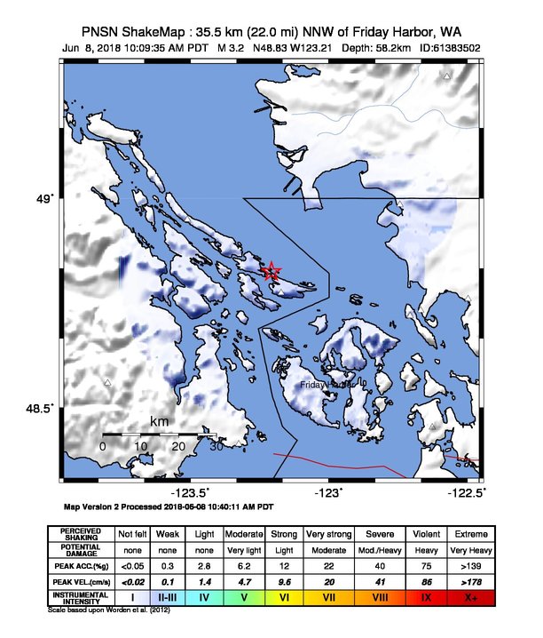
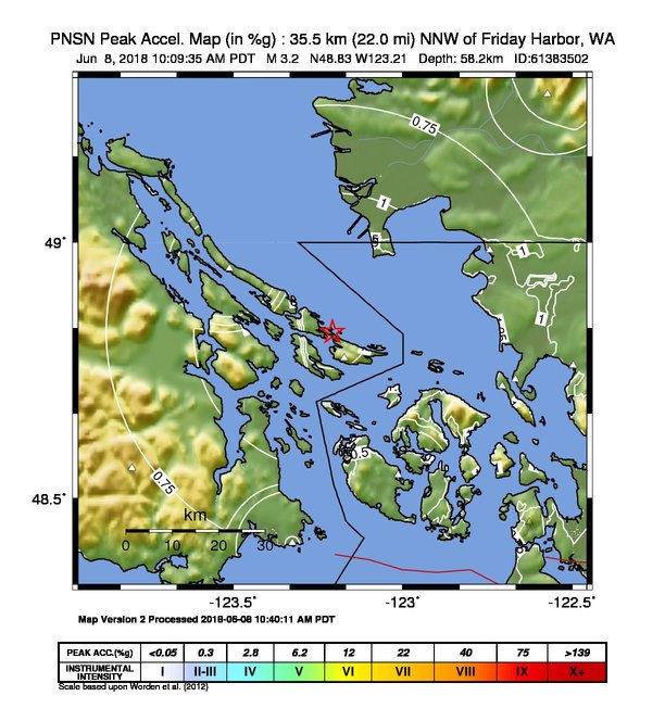
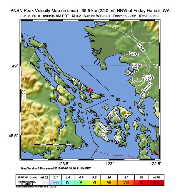
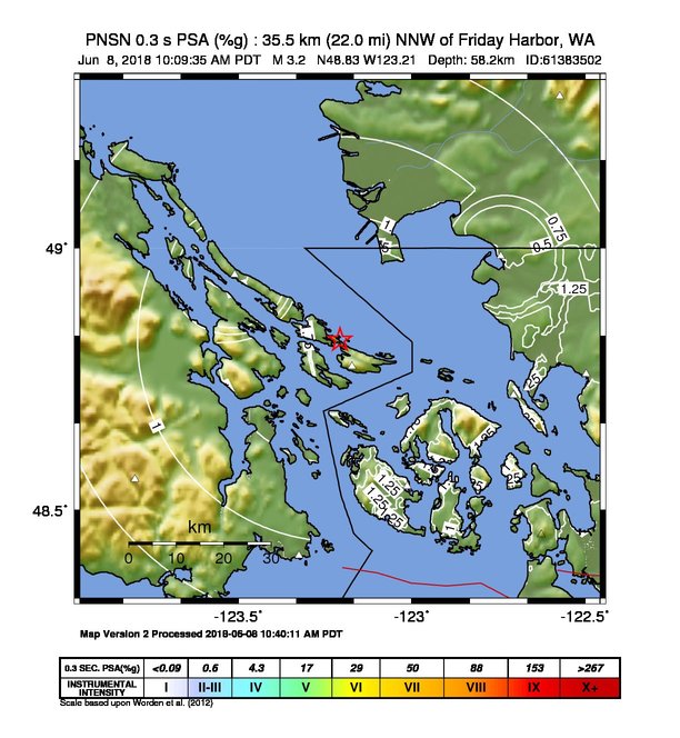
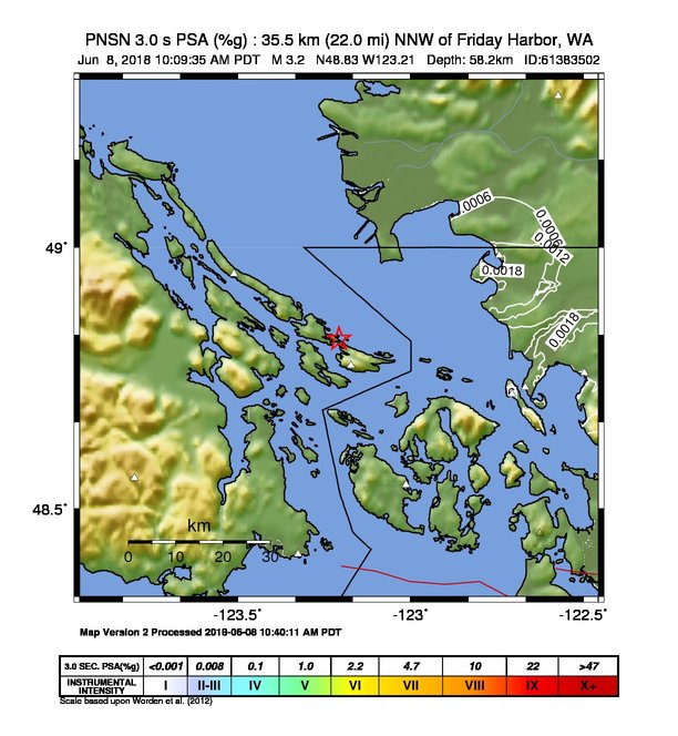
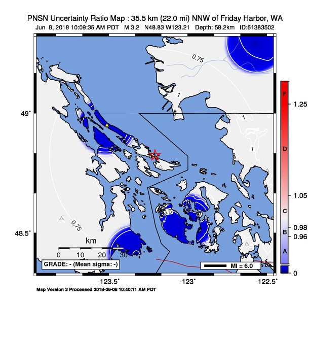
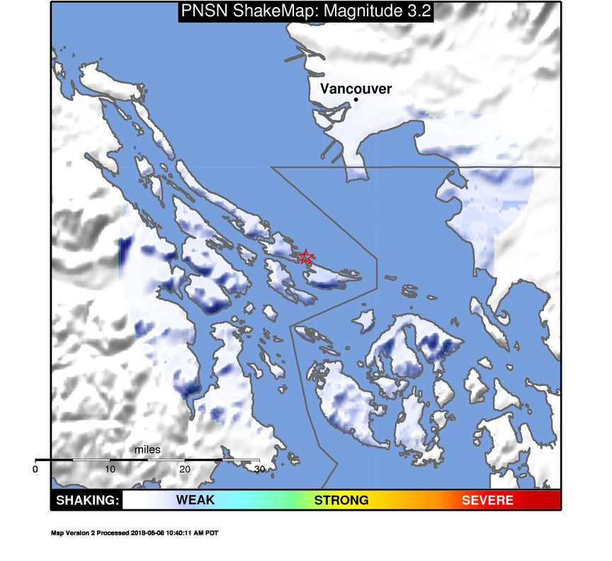
ShakeMap
Time:
Fri June 8, 2018 17:09:35 (UTC)
|
Depth:
58.21 km
|
Event ID:
61383502
|
Location:
48.825, -123.207

Downloads
| Regional | |
|---|---|
| intensity | JPG | PS.ZIP |
| acceleration | JPG | PS.ZIP |
| velocity | JPG | PS.ZIP |
| spectral 0.3 | JPG | PS.ZIP |
| spectral 1.0 | JPG | PS.ZIP |
| spectral 3.0 | JPG | PS.ZIP |
| uncertainty | JPG | PS.ZIP |
| tv map | JPG | PS.ZIP |
| tv map bare | JPG | PS.ZIP |
| tv info sheet | TXT |
| grid | XYZ.ZIP | XML.ZIP |
| gis | ZIP |
| station | TXT | XML |
| metadata | TXT |
Earthquake
| Event ID | Magnitude | Date | Time | Lat | Lon | Depth |
| 61383502 | 3.2 | // | :: | N48.82520 | W123.20700 | 58.21 km |
| Magnitude Bias: | MMI | PGA | PGV | PSA 0.3 | PSA 1.0 | PSA 3.0 |
| -0.48 | 0.00 | -0.87 | 0.00 | -1.95 | -1.04 |
Seismic Stations
| CN.GOBB: | Galiano Island, BC, CA | Agency: Canadian National Seismic Network | |||
| Lat: 48.94950 Lon: -123.51050 Distance: 63.81 km from source | |||||
| Intensity: 1.4 | |||||
| Station Comp | Max Vel (cm/s) | Max Acc (%g) | PSA: 0.3 sec (%g) | 1.0 sec (%g) | 3.0 sec (%g) |
| --.HHE | 0.0147 | 0.0880 | 0.0343 | 0.0035 | 0.0003 |
| --.HHN | 0.0228 | 0.0896 | 0.0957 | 0.0040 | 0.0004 |
| CN.HNBB: | Haney, BC, CA | Agency: Canadian National Seismic Network | |||
| Lat: 49.28730 Lon: -122.57290 Distance: 90.35 km from source | |||||
| Intensity: 1.0 | |||||
| Station Comp | Max Vel (cm/s) | Max Acc (%g) | PSA: 0.3 sec (%g) | 1.0 sec (%g) | 3.0 sec (%g) |
| --.HHE | 0.0063 | 0.0909 | 0.0177 -T | 0.0011 | 0.0001 |
| --.HHN | 0.0085 | 0.0511 | 0.0171 -T | 0.0008 | 0.0001 |
| CN.SNB: | Saturna Island, BC, CA | Agency: Canadian National Seismic Network | |||
| Lat: 48.77510 Lon: -123.17230 Distance: 58.53 km from source | |||||
| Intensity: 1.1 | |||||
| Station Comp | Max Vel (cm/s) | Max Acc (%g) | PSA: 0.3 sec (%g) | 1.0 sec (%g) | 3.0 sec (%g) |
| --.HHE | 0.0114 | 0.0869 -T | 0.0242 -T | 0.0032 | 0.0002 |
| --.HHN | 0.0167 | 0.0639 -T | 0.0483 -T | 0.0035 | 0.0003 |
| CN.SYMB: | Survey Mountain, BC, CA | Agency: Canadian National Seismic Network | |||
| Lat: 48.55930 Lon: -123.79890 Distance: 78.42 km from source | |||||
| Intensity: 1.0 | |||||
| Station Comp | Max Vel (cm/s) | Max Acc (%g) | PSA: 0.3 sec (%g) | 1.0 sec (%g) | 3.0 sec (%g) |
| --.HHE | 0.0053 | 0.0414 -T | 0.0075 -T | 0.0010 | 0.0001 |
| --.HHN | 0.0052 | 0.0317 -T | 0.0113 -T | 0.0009 | 0.0001 |
| CN.VGZ: | Victoria Gonzales, BC, CA | Agency: Canadian National Seismic Network | |||
| Lat: 48.41310 Lon: -123.32510 Distance: 74.59 km from source | |||||
| Intensity: 1.0 | |||||
| Station Comp | Max Vel (cm/s) | Max Acc (%g) | PSA: 0.3 sec (%g) | 1.0 sec (%g) | 3.0 sec (%g) |
| --.HHE | 0.0075 | 0.0465 | 0.0156 -T | 0.0014 | 0.0001 |
| --.HHN | 0.0120 | 0.0756 | 0.0176 -T | 0.0016 | 0.0002 |
| UW.ERW: | Mt. Erie, WA, USA | Agency: Pacific Northwest Seismic Network | |||
| Lat: 48.45383 Lon: -122.62612 Distance: 83.16 km from source | |||||
| Intensity: NaN | |||||
| Station Comp | Max Vel (cm/s) | Max Acc (%g) | PSA: 0.3 sec (%g) | 1.0 sec (%g) | 3.0 sec (%g) |
| --.HNN | 0.0012 -G | 0.0060 -G | 0.0044 -G | 0.0006 -G | 0.0001 -G |
| --.HNE | 0.0011 -G | 0.0062 -G | 0.0034 -G | 0.0004 -G | 0.0001 -G |
| UW.LUMI: | Lummi Island, WA | Agency: Pacific Northwest Regional Seismic Network | |||
| Lat: 48.72010 Lon: -122.70630 Distance: 69.79 km from source | |||||
| Intensity: 1.0 | |||||
| Station Comp | Max Vel (cm/s) | Max Acc (%g) | PSA: 0.3 sec (%g) | 1.0 sec (%g) | 3.0 sec (%g) |
| --.HHE | 0.0119 | 0.0404 -T | 0.0553 -T | 0.0026 | 0.0002 |
| --.HHN | 0.0138 | 0.0562 -T | 0.0413 -T | 0.0024 | 0.0002 |
| UW.QGBP: | Lena Rd. Bellingham, WA | Agency: Pacific Northwest Regional Seismic Network | |||
| Lat: 48.73338 Lon: -122.66756 Distance: 71.10 km from source | |||||
| Intensity: 1.0 | |||||
| Station Comp | Max Vel (cm/s) | Max Acc (%g) | PSA: 0.3 sec (%g) | 1.0 sec (%g) | 3.0 sec (%g) |
| 01.HNN | 0.0118 | 0.0620 -T | 0.0432 -T | 0.0060 | 0.0011 |
| 01.HNE | 0.0139 | 0.0472 -T | 0.0485 -T | 0.0055 | 0.0018 |
| 01.HNZ | 0.0049 | 0.0260 -T | 0.0130 -T | 0.0025 | 0.0015 |
| UW.QHSH: | Henry St. Bellingham, WA | Agency: Pacific Northwest Regional Seismic Network | |||
| Lat: 48.76047 Lon: -122.49662 Distance: 78.41 km from source | |||||
| Intensity: 1.0 | |||||
| Station Comp | Max Vel (cm/s) | Max Acc (%g) | PSA: 0.3 sec (%g) | 1.0 sec (%g) | 3.0 sec (%g) |
| 01.HNN | 0.0073 | 0.0239 -T | 0.0452 -T | 0.0027 | 0.0012 |
| 01.HNE | 0.0051 | 0.0402 -T | 0.0175 -T | 0.0029 | 0.0023 |
| 01.HNZ | 0.0040 | 0.0241 -T | 0.0168 -T | 0.0015 | 0.0012 |
| UW.QJLF: | Peace Portal Dr. Blaine, WA | Agency: Pacific Northwest Regional Seismic Network | |||
| Lat: 48.98512 Lon: -122.74295 Distance: 69.68 km from source | |||||
| Intensity: 1.5 | |||||
| Station Comp | Max Vel (cm/s) | Max Acc (%g) | PSA: 0.3 sec (%g) | 1.0 sec (%g) | 3.0 sec (%g) |
| 01.HNN | 0.0178 | 0.0533 -T | 0.0837 | 0.0062 | 0.0017 |
| 01.HNE | 0.0249 | 0.0493 -T | 0.1083 | 0.0071 | 0.0018 |
| 01.HNZ | 0.0107 | 0.1102 -T | 0.0265 | 0.0021 | 0.0018 |
| UW.UWFH: | UW Friday Harbor ANSS-SMO | Agency: Pacific Northwest Regional Seismic Network | |||
| Lat: 48.54593 Lon: -123.01324 Distance: 67.49 km from source | |||||
| Intensity: 1.2 | |||||
| Station Comp | Max Vel (cm/s) | Max Acc (%g) | PSA: 0.3 sec (%g) | 1.0 sec (%g) | 3.0 sec (%g) |
| --.ENN | 0.0121 | 0.0742 | 0.0173 -T | 0.0009 | 0.0002 |
| --.ENE | 0.0181 | 0.1069 | 0.0203 -T | 0.0015 | 0.0002 |