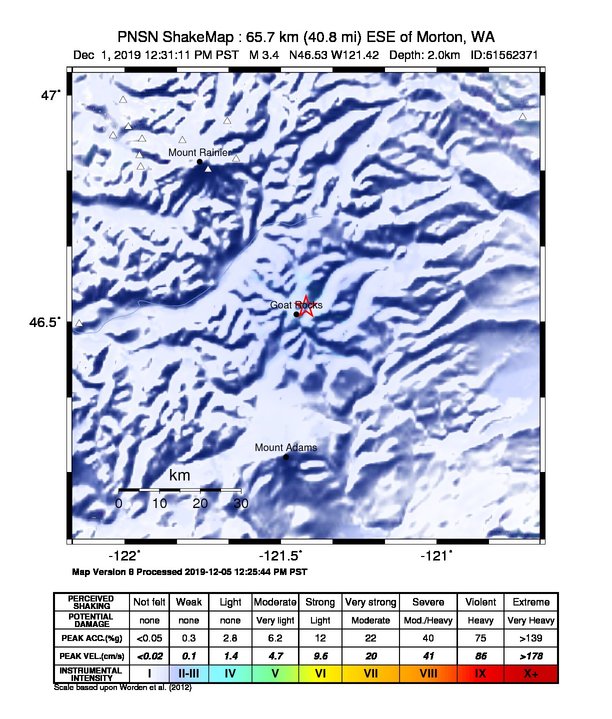
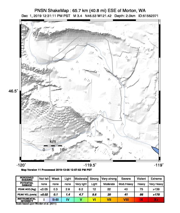
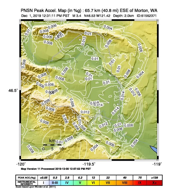
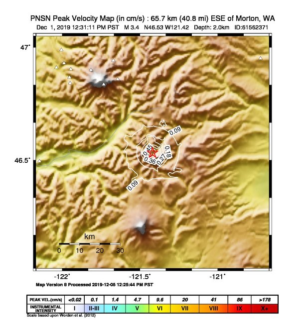
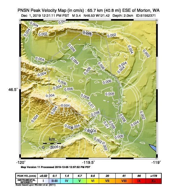
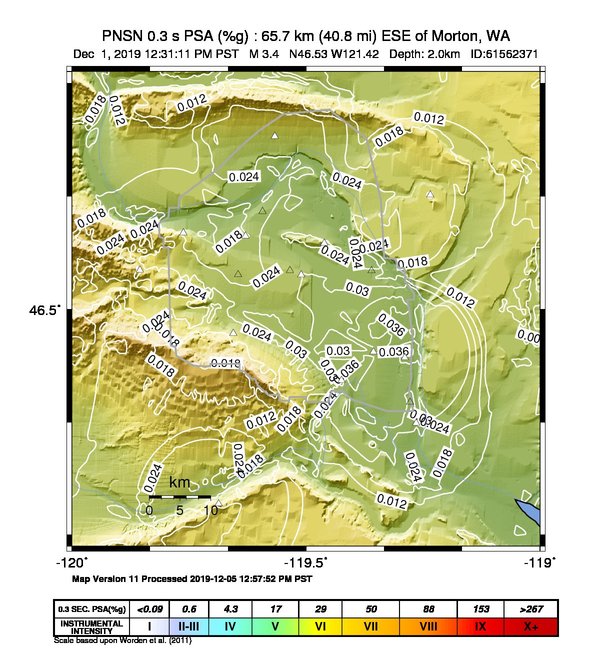
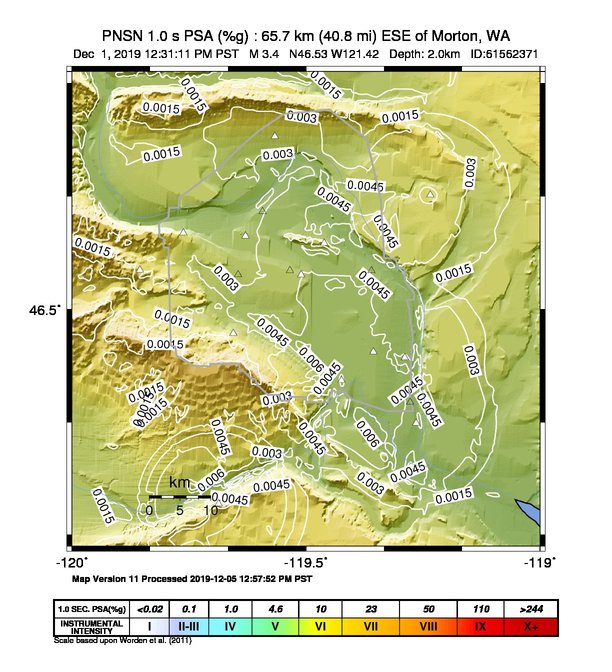
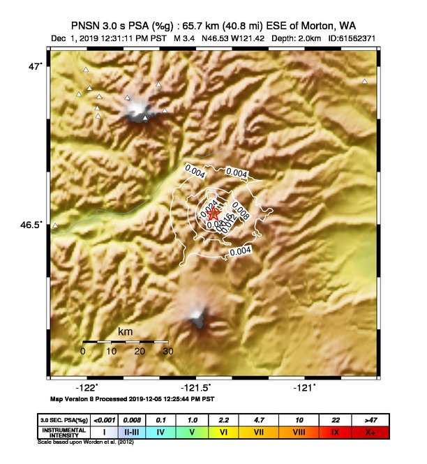
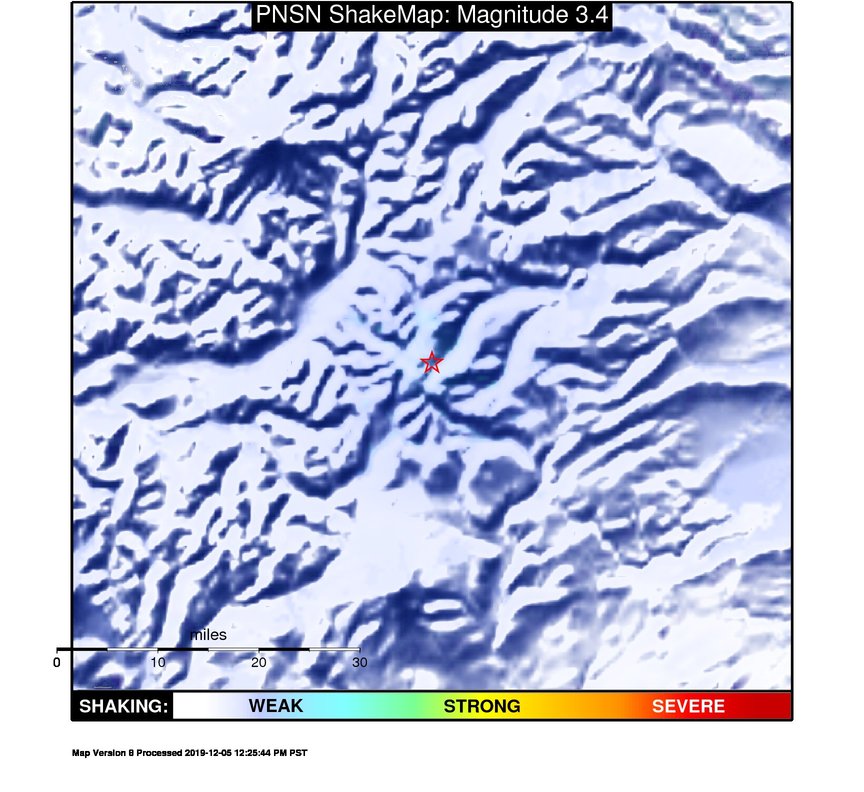
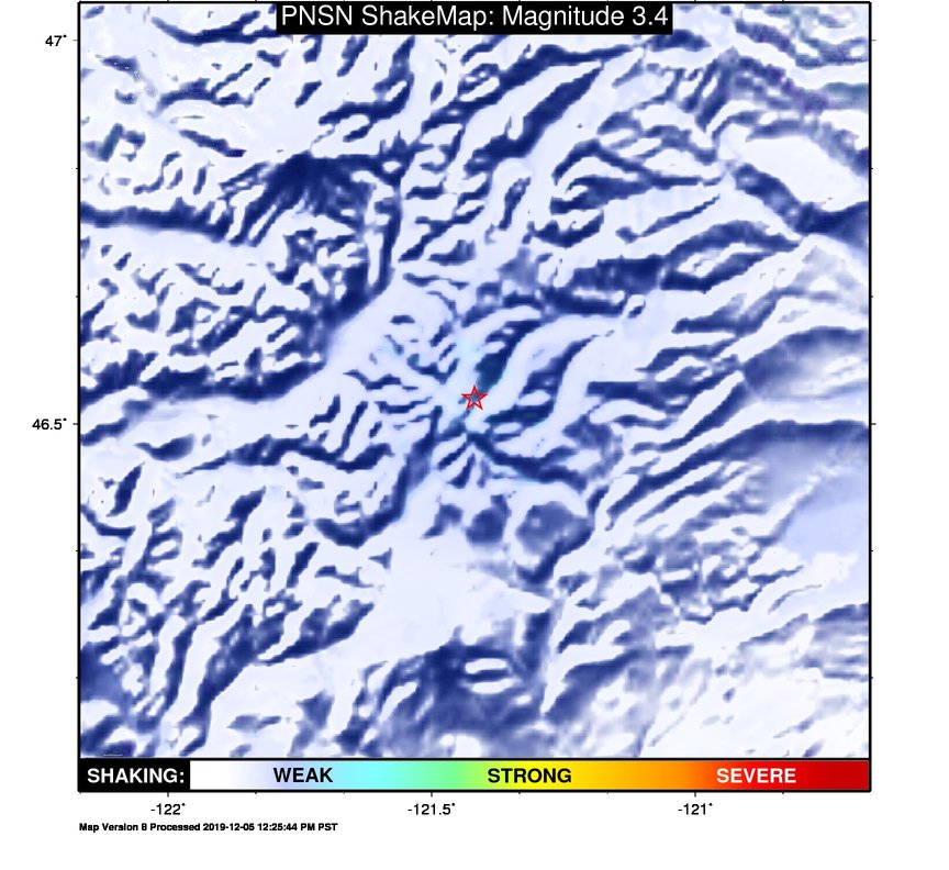
ShakeMap
Time:
Sun December 1, 2019 20:31:10 (UTC)
|
Depth:
2.46 km
|
Event ID:
61562371
|
Location:
46.535, -121.417


Downloads
| Regional | High Resolution Hanford | |
|---|---|---|
| intensity | JPG | PS.ZIP | JPG | PS.ZIP |
| acceleration | JPG | PS.ZIP | JPG | PS.ZIP |
| velocity | JPG | PS.ZIP | JPG | PS.ZIP |
| spectral 0.3 | JPG | PS.ZIP | JPG | PS.ZIP |
| spectral 1.0 | JPG | PS.ZIP | JPG | PS.ZIP |
| spectral 3.0 | JPG | PS.ZIP | JPG | PS.ZIP |
| uncertainty | JPG | PS.ZIP | JPG | PS.ZIP |
| tv map | JPG | PS.ZIP | JPG | PS.ZIP |
| tv map bare | JPG | PS.ZIP | JPG | PS.ZIP |
| tv info sheet | TXT | TXT |
| grid | XYZ.ZIP | XML.ZIP | XYZ.ZIP | XML.ZIP |
| gis | ZIP | ZIP |
| station | TXT | XML | TXT | XML |
| metadata | TXT | TXT |
Earthquake
| Event ID | Magnitude | Date | Time | Lat | Lon | Depth |
| 61562371 | 3.4 | // | :: | N46.53330 | W121.41900 | 1.97 km |
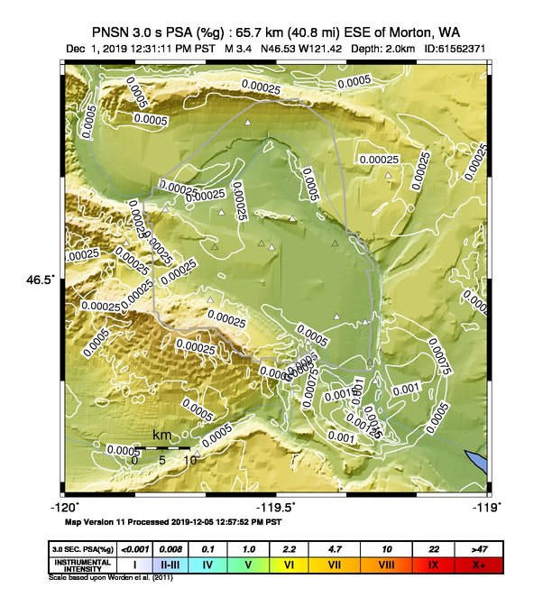
| Magnitude Bias: | MMI | PGA | PGV | PSA 0.3 | PSA 1.0 | PSA 3.0 |
| -1.33 | 0.12 | 0.06 | 0.04 | 0.21 | 0.29 |
Seismic Stations
| CC.CARB: | Carbon Repeater | Agency: Cascade Chain Volcano Monitoring | |||
| Lat: 46.98832 Lon: -122.00541 Distance: 67.52 km from source | |||||
| Intensity: 1.0 | |||||
| Station Comp | Max Vel (cm/s) | Max Acc (%g) | PSA: 0.3 sec (%g) | 1.0 sec (%g) | 3.0 sec (%g) |
| --.BHE | 0.0030 | 0.0102 | 0.0189 | 0.0027 | 0.0004 |
| --.BHN | 0.0034 | 0.0104 | 0.0194 | 0.0029 | 0.0004 |
| CC.OBSR: | Observation Rock, Mt. Rainier, WA | Agency: Cascade Chain Volcano Monitoring | |||
| Lat: 46.89972 Lon: -121.81533 Distance: 50.76 km from source | |||||
| Intensity: 1.0 | |||||
| Station Comp | Max Vel (cm/s) | Max Acc (%g) | PSA: 0.3 sec (%g) | 1.0 sec (%g) | 3.0 sec (%g) |
| --.BHE | 0.0134 | 0.0423 | 0.0832 | 0.0090 | 0.0011 |
| --.BHN | 0.0130 | 0.0466 | 0.0790 | 0.0119 | 0.0008 |
| CC.PANH: | Panhandle Gap | Agency: Cascade Chain Volcano Monitoring | |||
| Lat: 46.85903 Lon: -121.64259 Distance: 40.08 km from source | |||||
| Intensity: 2.0 | |||||
| Station Comp | Max Vel (cm/s) | Max Acc (%g) | PSA: 0.3 sec (%g) | 1.0 sec (%g) | 3.0 sec (%g) |
| --.BHE | 0.0404 | 0.1018 | 0.3241 | 0.0132 | 0.0012 |
| --.BHN | 0.0443 | 0.0961 | 0.2451 | 0.0130 | 0.0010 |
| CC.PR01: | Puyallup River 01 | Agency: Cascade Chain Volcano Monitoring | |||
| Lat: 46.91011 Lon: -122.03757 Distance: 63.11 km from source | |||||
| Intensity: 1.0 | |||||
| Station Comp | Max Vel (cm/s) | Max Acc (%g) | PSA: 0.3 sec (%g) | 1.0 sec (%g) | 3.0 sec (%g) |
| --.BHE | 0.0059 | 0.0272 | 0.0301 | 0.0021 | 0.0004 |
| --.BHN | 0.0069 | 0.0220 | 0.0300 | 0.0022 | 0.0003 |
| CC.PR04: | Puyallup River 04 | Agency: Cascade Chain Volcano Monitoring | |||
| Lat: 46.92977 Lon: -121.98859 Distance: 61.90 km from source | |||||
| Intensity: 1.0 | |||||
| Station Comp | Max Vel (cm/s) | Max Acc (%g) | PSA: 0.3 sec (%g) | 1.0 sec (%g) | 3.0 sec (%g) |
| --.BHE | 0.0054 | 0.0178 | 0.0195 | 0.0037 | 0.0005 |
| --.BHN | 0.0070 | 0.0176 | 0.0234 | 0.0040 | 0.0003 |
| CC.PR05: | Puyallup River 05 | Agency: Cascade Chain Volcano Monitoring | |||
| Lat: 46.84172 Lon: -121.94886 Distance: 53.04 km from source | |||||
| Intensity: 1.0 | |||||
| Station Comp | Max Vel (cm/s) | Max Acc (%g) | PSA: 0.3 sec (%g) | 1.0 sec (%g) | 3.0 sec (%g) |
| --.BHE | 0.0035 | 0.0125 | 0.0149 | 0.0026 | 0.0006 |
| --.BHN | 0.0038 | 0.0181 | 0.0134 | 0.0034 | 0.0004 |
| CC.RUSH: | Rushingwater Creek | Agency: Cascade Chain Volcano Monitoring | |||
| Lat: 46.90306 Lon: -121.94439 Distance: 57.43 km from source | |||||
| Intensity: 1.0 | |||||
| Station Comp | Max Vel (cm/s) | Max Acc (%g) | PSA: 0.3 sec (%g) | 1.0 sec (%g) | 3.0 sec (%g) |
| --.BHE | 0.0144 | 0.0506 | 0.1063 | 0.0092 | 0.0007 |
| --.BHN | 0.0107 | 0.0358 | 0.0576 | 0.0096 | 0.0007 |
| CC.SIFT: | Swift Creek | Agency: Cascade Chain Volcano Monitoring | |||
| Lat: 46.86687 Lon: -121.95320 Distance: 55.13 km from source | |||||
| Intensity: 1.0 | |||||
| Station Comp | Max Vel (cm/s) | Max Acc (%g) | PSA: 0.3 sec (%g) | 1.0 sec (%g) | 3.0 sec (%g) |
| --.BHE | 0.0033 | 0.0159 | 0.0168 | 0.0017 | 0.0003 |
| --.BHN | 0.0037 | 0.0153 | 0.0120 | 0.0025 | 0.0003 |
| UW.FMW: | Mt. Fremont, WA, USA | Agency: Pacific Northwest Seismic Network | |||
| Lat: 46.94191 Lon: -121.67146 Distance: 49.38 km from source | |||||
| Intensity: 1.0 | |||||
| Station Comp | Max Vel (cm/s) | Max Acc (%g) | PSA: 0.3 sec (%g) | 1.0 sec (%g) | 3.0 sec (%g) |
| --.HHE | 0.0105 | 0.0402 | 0.0560 | 0.0043 | 0.0010 |
| --.HHN | 0.0116 | 0.0371 | 0.0386 | 0.0026 | 0.0006 |
| UW.MANO: | Manatash Ridge Observatory, Ellensburg, WA, USA | Agency: Pacific Northwest Seismic Network | |||
| Lat: 46.95110 Lon: -120.72469 Distance: 70.44 km from source | |||||
| Intensity: 1.0 | |||||
| Station Comp | Max Vel (cm/s) | Max Acc (%g) | PSA: 0.3 sec (%g) | 1.0 sec (%g) | 3.0 sec (%g) |
| --.HHE | 0.0046 | 0.0068 | 0.0167 | 0.0049 | 0.0004 |
| --.HHN | 0.0038 | 0.0058 | 0.0178 | 0.0038 | 0.0008 |
| UW.PUPY: | Dog Mt, WA, USA | Agency: Pacific Northwest Seismic Network | |||
| Lat: 46.49542 Lon: -122.14613 Distance: 55.84 km from source | |||||
| Intensity: 1.1 | |||||
| Station Comp | Max Vel (cm/s) | Max Acc (%g) | PSA: 0.3 sec (%g) | 1.0 sec (%g) | 3.0 sec (%g) |
| --.ENN | 0.0170 | 0.0930 | 0.0673 | 0.0049 | 0.0015 |
| --.ENE | 0.0167 | 0.1059 | 0.0516 | 0.0055 | 0.0012 |
| UW.RCM: | Mt. Rainier, Camp Muir | Agency: Pacific Northwest Seismic Network | |||
| Lat: 46.83564 Lon: -121.73298 Distance: 41.32 km from source | |||||
| Intensity: 1.0 | |||||
| Station Comp | Max Vel (cm/s) | Max Acc (%g) | PSA: 0.3 sec (%g) | 1.0 sec (%g) | 3.0 sec (%g) |
| --.HHE | 0.0052 | 0.0213 | 0.0221 | 0.0053 | 0.0007 |
| --.HHN | 0.0050 | 0.0236 | 0.0281 | 0.0038 | 0.0004 |
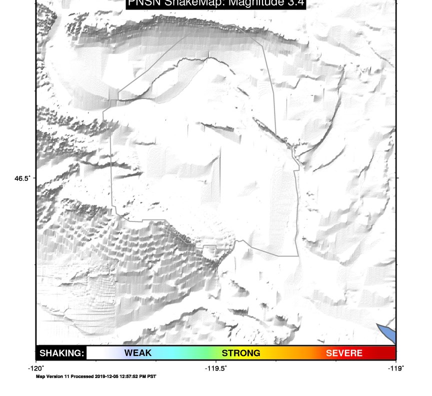
Earthquake
| Event ID | Magnitude | Date | Time | Lat | Lon | Depth |
| 61562371 | 3.4 | // | :: | N46.53330 | W121.41900 | 1.97 km |
| Magnitude Bias: | MMI | PGA | PGV | PSA 0.3 | PSA 1.0 | PSA 3.0 |
| -1.46 | -0.01 | 0.01 | 0.16 | 0.11 | 0.30 |
Seismic Stations
| UW.CCRK: | Sunnyside, WA, USA | Agency: Pacific Northwest Seismic Network | |||
| Lat: 46.55850 Lon: -119.85480 Distance: 119.67 km from epicenter | |||||
| Intensity: 1.0 | |||||
| Station Comp | Max Vel (cm/s) | Max Acc (%g) | PSA: 0.3 sec (%g) | 1.0 sec (%g) | 3.0 sec (%g) |
| --.HHE | 0.0036 | 0.0063 | 0.0224 | 0.0020 | 0.0002 |
| --.HHN | 0.0028 | 0.0058 | 0.0286 | 0.0011 | 0.0002 |
| UW.GBB: | GBB, Hanford, WA, USA | Agency: Pacific Northwest Seismic Network | |||
| Lat: 46.60869 Lon: -119.62898 Distance: 137.10 km from epicenter | |||||
| Intensity: 1.0 | |||||
| Station Comp | Max Vel (cm/s) | Max Acc (%g) | PSA: 0.3 sec (%g) | 1.0 sec (%g) | 3.0 sec (%g) |
| --.HHE | 0.0014 | 0.0043 | 0.0113 | 0.0011 | 0.0001 |
| --.HHN | 0.0021 | 0.0047 | 0.0146 | 0.0018 | 0.0001 |
| UW.GRUT: | Wet-Grout Plant, Hanford, WA | Agency: Pacific Northwest Regional Seismic Network | |||
| Lat: 46.55122 Lon: -119.51028 Distance: 146.01 km from epicenter | |||||
| Intensity: 1.0 | |||||
| Station Comp | Max Vel (cm/s) | Max Acc (%g) | PSA: 0.3 sec (%g) | 1.0 sec (%g) | 3.0 sec (%g) |
| --.ENN | 0.0071 | 0.0121 | 0.0350 | 0.0048 | 0.0003 |
| --.ENE | 0.0044 | 0.0110 | 0.0243 | 0.0025 | 0.0003 |
| UW.H1K: | 100 K Area, Hanford, WA, USA | Agency: Pacific Northwest Regional Seismic Network | |||
| Lat: 46.64468 Lon: -119.59287 Distance: 140.11 km from epicenter | |||||
| Intensity: NaN | |||||
| Station Comp | Max Vel (cm/s) | Max Acc (%g) | PSA: 0.3 sec (%g) | 1.0 sec (%g) | 3.0 sec (%g) |
| --.ENN | 0.0039 -G | 0.0065 -G | 0.0168 -G | 0.0022 -G | 0.0002 -G |
| --.ENE | 0.0026 -G | 0.0066 -G | 0.0163 -G | 0.0023 -G | 0.0001 -G |
| UW.H2E: | 200 East Area, Hanford, WA, USA | Agency: Pacific Northwest Seismic Network | |||
| Lat: 46.55780 Lon: -119.53450 Distance: 144.16 km from epicenter | |||||
| Intensity: NaN | |||||
| Station Comp | Max Vel (cm/s) | Max Acc (%g) | PSA: 0.3 sec (%g) | 1.0 sec (%g) | 3.0 sec (%g) |
| --.HNN | 0.0058 | 0.0103 | 0.0418 | 0.0039 | 0.0003 |
| --.HNE | 0.0038 -G | 0.0094 -G | 0.0237 -G | 0.0028 -G | 0.0002 -G |
| UW.H2O: | H2O, Hanford, WA, USA | Agency: Pacific Northwest Seismic Network | |||
| Lat: 46.39555 Lon: -119.42411 Distance: 153.57 km from epicenter | |||||
| Intensity: 1.0 | |||||
| Station Comp | Max Vel (cm/s) | Max Acc (%g) | PSA: 0.3 sec (%g) | 1.0 sec (%g) | 3.0 sec (%g) |
| --.HHE | 0.0033 | 0.0058 | 0.0216 | 0.0017 | 0.0001 |
| --.HHN | 0.0059 | 0.0108 | 0.0191 | 0.0032 | 0.0003 |
| UW.H2W: | 200 West Area, Hanford, WA, USA | Agency: Pacific Northwest Seismic Network | |||
| Lat: 46.55170 Lon: -119.64532 Distance: 135.68 km from epicenter | |||||
| Intensity: NaN | |||||
| Station Comp | Max Vel (cm/s) | Max Acc (%g) | PSA: 0.3 sec (%g) | 1.0 sec (%g) | 3.0 sec (%g) |
| --.HNN | 0.0039 -G | 0.0075 -G | 0.0330 -G | 0.0021 -G | 0.0001 -G |
| --.HNE | 0.0039 -G | 0.0082 -G | 0.0279 -G | 0.0023 -G | 0.0001 -G |
| UW.H3A: | 300 Area, Hanford, WA, USA | Agency: Pacific Northwest Seismic Network | |||
| Lat: 46.36322 Lon: -119.27747 Distance: 165.16 km from epicenter | |||||
| Intensity: NaN | |||||
| Station Comp | Max Vel (cm/s) | Max Acc (%g) | PSA: 0.3 sec (%g) | 1.0 sec (%g) | 3.0 sec (%g) |
| --.HNN | 0.0066 | 0.0124 | 0.0311 | 0.0036 | 0.0003 |
| --.HNE | 0.0036 -G | 0.0088 -G | 0.0224 -G | 0.0016 -G | 0.0001 -G |
| UW.H4A: | 400 Area, Hanford, WA, USA | Agency: Pacific Northwest Seismic Network | |||
| Lat: 46.43774 Lon: -119.35567 Distance: 158.34 km from epicenter | |||||
| Intensity: 1.0 | |||||
| Station Comp | Max Vel (cm/s) | Max Acc (%g) | PSA: 0.3 sec (%g) | 1.0 sec (%g) | 3.0 sec (%g) |
| --.HNN | 0.0075 | 0.0139 | 0.0309 | 0.0052 | 0.0004 |
| --.HNE | 0.0044 | 0.0133 | 0.0349 | 0.0049 | 0.0002 |
| UW.HGBL: | Gable Mountain, Hanford, WA, USA | Agency: Pacific Northwest Seismic Network | |||
| Lat: 46.59801 Lon: -119.46081 Distance: 149.88 km from epicenter | |||||
| Intensity: 1.0 | |||||
| Station Comp | Max Vel (cm/s) | Max Acc (%g) | PSA: 0.3 sec (%g) | 1.0 sec (%g) | 3.0 sec (%g) |
| --.ENN | 0.0050 | 0.0102 | 0.0277 | 0.0036 | 0.0003 |
| --.ENE | 0.0043 | 0.0104 | 0.0191 | 0.0023 | 0.0002 |
| UW.HWIW: | Wooded Island, Hanford, WA, USA | Agency: Pacific Northwest Seismic Network | |||
| Lat: 46.42917 Lon: -119.28896 Distance: 163.51 km from epicenter | |||||
| Intensity: 1.0 | |||||
| Station Comp | Max Vel (cm/s) | Max Acc (%g) | PSA: 0.3 sec (%g) | 1.0 sec (%g) | 3.0 sec (%g) |
| --.ENN | 0.0114 | 0.0214 | 0.0570 | 0.0047 | 0.0004 |
| --.ENE | 0.0074 | 0.0150 | 0.0342 | 0.0027 | 0.0002 |
| UW.MDW: | Midway | Agency: Pacific Northwest Seismic Network | |||
| Lat: 46.61302 Lon: -119.76215 Distance: 126.97 km from epicenter | |||||
| Intensity: 1.0 | |||||
| Station Comp | Max Vel (cm/s) | Max Acc (%g) | PSA: 0.3 sec (%g) | 1.0 sec (%g) | 3.0 sec (%g) |
| --.HHE | 0.0017 | 0.0041 | 0.0075 | 0.0010 | 0.0001 |
| --.HHN | 0.0030 | 0.0055 | 0.0186 | 0.0014 | 0.0002 |
| UW.MJ2: | May Junction 2 | Agency: Pacific Northwest Seismic Network | |||
| Lat: 46.55736 Lon: -119.36013 Distance: 157.49 km from epicenter | |||||
| Intensity: NaN | |||||
| Station Comp | Max Vel (cm/s) | Max Acc (%g) | PSA: 0.3 sec (%g) | 1.0 sec (%g) | 3.0 sec (%g) |
| --.ENN | 0.0045 -G | 0.0093 -G | 0.0122 -G | 0.0028 -G | 0.0003 -G |
| --.ENE | 0.0029 -G | 0.0085 -G | 0.0163 -G | 0.0016 -G | 0.0001 -G |
| UW.OT3: | New Othello (replaces OT2 8/26/94) | Agency: Pacific Northwest Seismic Network | |||
| Lat: 46.66886 Lon: -119.23413 Distance: 167.61 km from epicenter | |||||
| Intensity: 1.0 | |||||
| Station Comp | Max Vel (cm/s) | Max Acc (%g) | PSA: 0.3 sec (%g) | 1.0 sec (%g) | 3.0 sec (%g) |
| --.HHE | 0.0046 | 0.0121 | 0.0289 | 0.0054 | 0.0001 |
| --.HHN | 0.0052 | 0.0107 | 0.0296 | 0.0042 | 0.0003 |
| UW.PRO: | Prosser, WA, USA (was ISC code PRW) | Agency: Pacific Northwest Seismic Network | |||
| Lat: 46.21252 Lon: -119.68681 Distance: 137.61 km from epicenter | |||||
| Intensity: 1.0 | |||||
| Station Comp | Max Vel (cm/s) | Max Acc (%g) | PSA: 0.3 sec (%g) | 1.0 sec (%g) | 3.0 sec (%g) |
| --.HHE | 0.0048 | 0.0079 | 0.0217 | 0.0043 | 0.0003 |
| --.HHN | 0.0038 | 0.0071 | 0.0231 | 0.0032 | 0.0002 |
| UW.QWSU: | Richland, WA, USA | Agency: Pacific Northwest Regional Seismic Network | |||
| Lat: 46.33230 Lon: -119.26480 Distance: 166.60 km from epicenter | |||||
| Intensity: 1.0 | |||||
| Station Comp | Max Vel (cm/s) | Max Acc (%g) | PSA: 0.3 sec (%g) | 1.0 sec (%g) | 3.0 sec (%g) |
| 01.HNN | 0.0057 | 0.0095 | 0.0231 | 0.0044 | 0.0010 |
| 01.HNE | 0.0053 | 0.0094 | 0.0266 | 0.0030 | 0.0012 |
| 01.HNZ | 0.0036 | 0.0072 | 0.0092 | 0.0020 | 0.0013 |
| UW.SNI2: | Snively Ranch 2, Hanford, WA, USA | Agency: Pacific Northwest Seismic Network | |||
| Lat: 46.46480 Lon: -119.65515 Distance: 135.24 km from epicenter | |||||
| Intensity: 1.0 | |||||
| Station Comp | Max Vel (cm/s) | Max Acc (%g) | PSA: 0.3 sec (%g) | 1.0 sec (%g) | 3.0 sec (%g) |
| --.HHE | 0.0035 | 0.0051 | 0.0152 | 0.0030 | 0.0001 |
| --.HHN | 0.0052 | 0.0076 | 0.0272 | 0.0026 | 0.0002 |
| UW.WA2: | Wahluke Slope previous ISC code: WAH2 | Agency: Pacific Northwest Seismic Network | |||
| Lat: 46.75519 Lon: -119.56681 Distance: 143.54 km from epicenter | |||||
| Intensity: 1.0 | |||||
| Station Comp | Max Vel (cm/s) | Max Acc (%g) | PSA: 0.3 sec (%g) | 1.0 sec (%g) | 3.0 sec (%g) |
| --.HHE | 0.0057 | 0.0148 | 0.0256 | 0.0019 | 0.0002 |
| --.HHN | 0.0083 | 0.0135 | 0.0362 | 0.0040 | 0.0004 |