Landslides
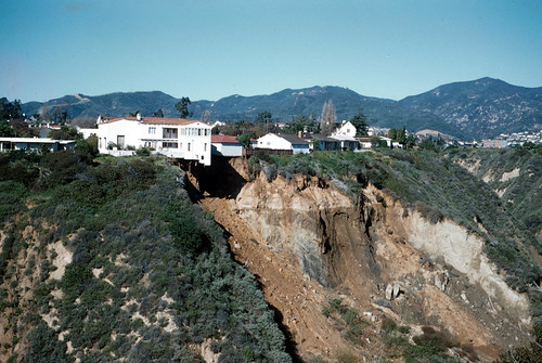
Landslides, in and of themselves, constitute a major geologic hazard. They are widespread, result in $1-2 billion in damages, and cause more than 25 fatalities each year. Landslides are frequently triggered by strong ground motions. They are an important secondary earthquake hazard.
The term landslide includes a wide range of ground movement, such as rock falls, deep failure of slopes, and shallow debris flows. Gravity acting on a steep slope is the primary reason for all landslides, but there are a number of other contributing factors:
• erosion by rivers, glaciers, or ocean waves create oversteepened slopes
• rock and soil slopes are weakened through saturation by snowmelt or heavy rains
• excess weight from accumulation of rain or snow, stockpiling of rock or ore, from waste piles, or from man-made structures may stress weak slopes to failure and other structures
Earthquakes and volcanoes contribute significantly to the landslide hazards:
• earthquakes create stresses that make weak slopes fail
• earthquakes of magnitude 4.0 and greater have been known to trigger landslides
• volcanic eruptions produce loose ash deposits, heavy rain, and debris flows
Landslides triggered by earthquake shaking are a major concern in the Pacific Northwest. Earthquake Point in Chelan County, Washington, near Entiat is named after the ~ M7 1872 earthquake that struck nearby. The shaking split the mountain, forming the cliff to the west and causing a huge rock slide which stopped the flow of the Columbia River for several hours.
Strong earthquake ground shaking greatly increases the likelihood of landslides where landscape is susceptible to these types of ground failure. If the ground is saturated with water, particularly following heavy rainfall, the shaking will result in more landslides than normal.
The Washington State Department of Ecology has published information about landslides, historic events, and mitigation. The City of Seattle offers valuable landslide hazard, preparedness, and policy information. Learn more about Oregon landslides from DOGAMI.