M2.4 earthquake - 16.03 mi SW from Coos Bay, OR
Status: Reviewed
0 Felt ReportsReport your experience
Magnitude2.4Time2025/11/09 10:04:05 AM UTCDepth9.88 miCoordinates43.1553, -124.3443ID62203512
Origin
Statistics on estimate of an earthquake's location and time. For more info, see Earthquake Terminology.Orid
3361293Magnitude
2.43Time
1762682672.42Latitude
43.15533Longitude
-124.34433Depth
9.88 miLocation Quality
ExcellentEvent ID
62203512Event Type
eqGtype
lHorizontal Uncertainty
0.39 miDepth Uncertainty
0.57 miAzimuthal Gap
156 degNumber of Phases
38RMS Misfit
0.36Focal Mechanisms
Describes the fault orientation and slip direction of an earthquake and are generated using first motion (up or down) observations.Solution 1
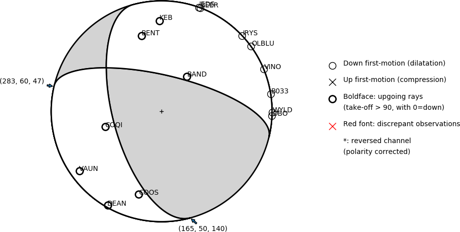
Number of P First motions: 15
| Plane A | Plane B | Uncertainty | |
|---|---|---|---|
| Strike | 165 | 283 | 30 |
| Dip | 50 | 60 | 38 |
| Rake | 140 | 47 | 35 |
Discrepant Stations
Stations whose observed first-motion does not match the predicted first-motion from the focal mechanism.| Station | Network | Channel | Polarity | Quality |
|---|---|---|---|---|
No items. | ||||