M1.6 earthquake - 19.39 mi SE from Tillamook, OR
Status: Reviewed
0 Felt ReportsReport your experience
Magnitude1.6Time2025/12/11 07:03:06 AM UTCDepth12.73 miCoordinates45.303, -123.5088ID62209257
Origin
Statistics on estimate of an earthquake's location and time. For more info, see Earthquake Terminology.Orid
3365468Magnitude
1.60Time
1765436613.6599998Latitude
45.30300Longitude
-123.50883Depth
12.73 miLocation Quality
ExcellentEvent ID
62209257Event Type
eqGtype
lHorizontal Uncertainty
0.17 miDepth Uncertainty
0.44 miAzimuthal Gap
50 degNumber of Phases
32RMS Misfit
0.15Focal Mechanisms
Describes the fault orientation and slip direction of an earthquake and are generated using first motion (up or down) observations.Solution 1

Number of P First motions: 10
| Plane A | Plane B | Uncertainty | |
|---|---|---|---|
| Strike | 10 | 244 | 33 |
| Dip | 75 | 24 | 28 |
| Rake | -110 | -38 | 40 |
Discrepant Stations
Stations whose observed first-motion does not match the predicted first-motion from the focal mechanism.| Station | Network | Channel | Polarity | Quality |
|---|---|---|---|---|
No items. | ||||
Solution 2
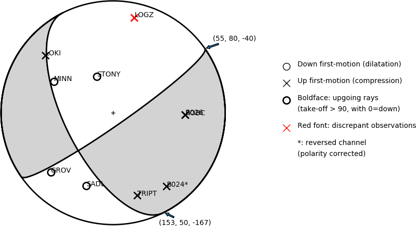
Number of P First motions: 10
| Plane A | Plane B | Uncertainty | |
|---|---|---|---|
| Strike | 55 | 153 | 15 |
| Dip | 80 | 50 | 23 |
| Rake | -40 | -167 | 15 |
Discrepant Stations
Stations whose observed first-motion does not match the predicted first-motion from the focal mechanism.| Station | Network | Channel | Polarity | Quality |
|---|---|---|---|---|
| LOGZ | UO | HHZ | U | 0.9243 |