ETS Event of Fall 2020
Shortcuts:
Main Tremor Index | Interactive Tremor Map | Compare Maps | PANGA geodesy plots
Blog for ETS of Fall 2020
Deep Tremor News: Fall - Winter 2020
This BLOG-like page is being generated in a form similar to previous ETS ones to document and provide information on a Northern Washington ETS that should start sometime between Oct. and Dec, 2020. There are no special experiments in the field for this ETS. We will be tracking and reporting on this ETS using data only from the real-time regional networks (UW, UO, CN, PB, CA) and/or information reported to us by others.
Produced by Steve Malone, PNSN Professor Emeritus
ETS dates:
Start: Oct. 4, 2020 (late in the day) , Second batch start Jan. 26, 2021
End: Nov. 16, 2020 , Second batch ends: Feb 11, 2021
Information will be posted on this page (latest at the bottom) and references to figures from time to time.
NEWS (latest is at the bottom):
Sep. 16, 2020 - In anticipation of a routine ETS (or pair of them) in the northern Washington (NWA) - southern Vancouver Island (SVI) section of Cascadia I am starting this blog a bit early. Of course, how this next ETS will start and if it will be one regular event (as typical over the past 15 years) or come as a pair as it (they) did last year is unknown at this point. If one looks at the details of the 2019 - summer ETS one sees that it really was two smaller ETS events separated by over two months. Thus we really don't know when the typical repeat time of ~14 months clock should start. The recent burst of activity in Southern Vancouver Island seems to be just that, a burst of a few days and not strong or long enough to be an ETS. The next ETS in this area could start as soon as early October or it might not be until January, 2021; or there could be again two separate ETS events separated by months. ETS sequences are far from understood so any number of things are possible. Stay tuned.
By the way, we have received inquiries from several people about reports of an unprecedented amount of tremor taking place recently. It is not clear to us why some think there is significantly unusual tremor activity taking place. There is not. We recommend before folks get all excited about what our daily tremor page shows that one review the data and reports for the past 15+ years. Lots of details can be found in the individual reports listed at the Tremor Overview page and a very good summary of overall tremor patterns was written by Aaron Wech, an expert in such events not only in Cascadia but also elsewhere in the world called A Perspective on Tremor Activity. Dr. Wech recently allowed how we should keep in mind the break or change in the catalog that occurred in February 2018 when he upgraded the monitoring system. Changes in the clustering/detection algorithm then result in a ~50% increase in detected epicenters, so comparing raw number of detections today vs before 2018 isn't apples to apples. Having tremor take place up and down Cascadia at the same time has occurred several times in the past 15 years and thus is not unprecedented. A report on an example can be found at Deep Tremor over much of Cascadia from back in 2013.
Oct. 9, 2020 - I am not officially calling it started.... but... the next NWA-SVI ETS may have started. Since Oct 4 there seems to be increasing amounts of tremor each day in the central Puget Sound area. Normally we like to wait to see a week of significant tremor every day before we think an ETS is really underway. There have been periods in the past where several days of tremor peters out just about the time we think a real ETS is going. We definitely are in the time period, almost exactly 14 months since the beginning of the previous ETS. That one started on Aug 11, 2019 with tremor in the central Puget Sound and then slowly progressed to the north before pausing two weeks later not to start again for another two months. The tremor of the past few days is roughly in the same place. Looking at the original data and envelopes it does seem to be a bit stronger over the past two days than when it started. So, very tentatively..... it has..... nah, I'll wait a couple more days before an official pronouncement.
Oct. 11, 2020 - OK, OK so it has started already. Indeed, as tentatively said before it seems late in the day on Oct 4 is when the first tremor was detected and since then there has been continuing tremor off and on every day, getting stronger over the last few days. This event seems to have started just west of Seattle, under the Kitsap Peninsula and then over the next few days moved slightly to the west (up dip on the plate interface) and spread both north and south. Over the past couple of days there is a hint that more events are in the northern part of the patch and thus maybe it has started moving north.... just as it should to become a regular NWA-SVI ETS event.
As additional confirmation I heard from none oher than Dr. "Slow-Slip" himself, Herb Dragert one of the original discoverers and namers of "Eposodic Tremor and Slip" who sent me the following: "If I squint hard at the GPS results, there is the indication of westward displacement at a number of GPS sites on the west side of Puget Sound and perhaps one more day of data will confirm this". Herb, like me, retired a few years ago but can't seem to help "playing" with interesting geophysical activity. I trust his bleary eyes and so will not even wait for one more day.
Oh dear, I just heard from another ETS nerd. Dr. Ken Creager, who helped his then graduate student, Aaron Wech develop the famous "wech-o-meter" (tremor detections and plotting system) just sent me a warning that: "Using the Legacy detections (original, less sensitive wech-o-meter), and the last 7 years of data, about half of the tremor swarms in this area that reach 70 hours (this one has just over 70 so far) have turned out to be ETS and half have not". Ok, better than half the cases reported.... I will take those odds and still proclaim: "THIS DUDE HAS STARTED". Of course, I have been embarrassingly wrong many times before. So, fire me. Oh, already retired, so not an option.
Oct 15, 2020 - It is now double official! While this seismologist tried to look at some GPS data and ended up with his eyes crossed and couldn't figure out what was doing what where, I got the following note from Herb Dragert, a real (though retired) geodesist.
- I have attached graphs of the recent surface displacements for 4 GNSS sites that show the accumulating westerly offsets most clearly at this point in time. Note that there are other (noisier) sites that are not nearly as clear cut and quite a number of Puget Sound sites that are not included in our routine analyses, so the overall extent of the deformation region is not yet established. The largest horizontal offset observed so far from our analyses is about 8mm, seen at site P418 (Matlock) which is located roughly 24 km due west of Shelton.
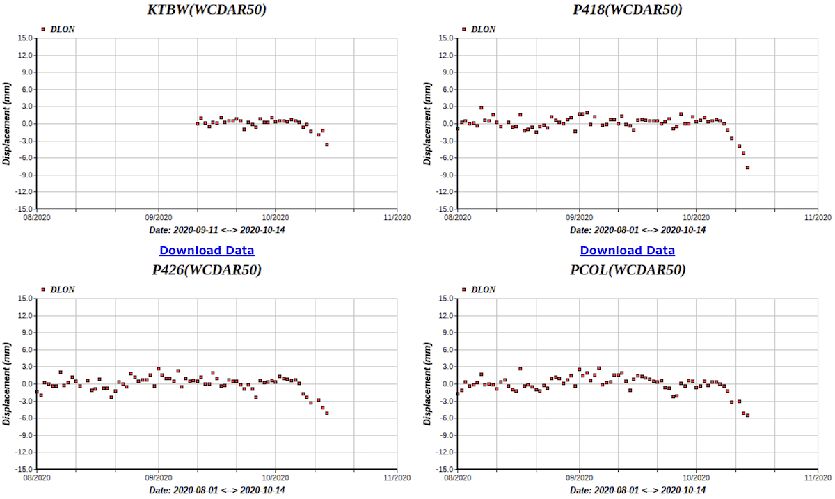
Even a seismologist such as myself can see there are obvious deviations from the background levels that start about Oct 6 or 7, only a few days after the first tremor was observed. Herb seems to know how to get the correct data and process/plot it to best show what is going on.
The latest tremor locations seem to have spread both south and a bit north and early this morning a patch jumped all the way onto southern Vancouver Island leaving a gap in between them and those in the Olympics. I would expect this gap to fill in over the next few days unless, of course, those Canadian tremor events are smart enough to keep an appropriate "social distance" from the US ones.
Oct 22, 2020 - Sure enough, I said it would go one way (north and fill in the gap) and it goes the other (south). Three days after my previous post the tremor died out on Vancouver Island. It has not (yet) filled in the gap between NWA and SVI, but instead started moving slowly south. Below is a tremor map color coded by time (blue early and red recent)
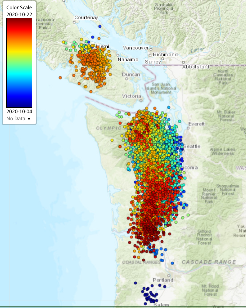
There are a lot of individual tremor detections plotted on here but one can see a pattern of starting just west of Seattle (with a small blob down near Portland), then moving west and spreading a bit north and south. During a four day period (Oct 15-18) it continued in the central part but also had a bunch up on Vancouver Island. After that it started moving slowly to the south. It is now about to close the gap between the early Portland bunch and the main one.
The GPS motions associated with this are now quite clear on a number of stations in the central to south Puget Sound region, but stations to the south in southern Washington have not yet shown any obvious motion. We will be working on looking at the GPS data more over the next day or two.
Nov 5, 2020 - There wasn’t much change in the slow progression of the current ETS southward until a couple of days ago when it seem to start to fade out just as it reached the Portland area and then jumped back to the north end of the Olympic Peninsula. The question is, will it soon escape the virus infected US to the relatively safe British Columbia area. I would be a little surprised if this event extended north into much of the zone that was active last November; at least not for a couple of months. But, I am wrong about this sort of thing more often than right, so….
Nov 9, 2020 - OK, looks as if I was wrong... again. I am beginning to think this tremor activity is following me. On Nov. 30 my wife and I headed to British Columbia to visit our daughter and her family. The Canadians only allow immediate family in and require all visitors to quarantine for two weeks on arrival, so we have been holed up alone in a small house with little to do other than surf the internet and watch this ETS. About the time we left the US the tremor jumped up near the border and more recently started across the border following us. The last couple of days it has been strong tremor much of the day and is now under southern Vancouver Island. It looks as if this will end up a complete ETS eventually covering the entire zone it normally does for the standard 14-month ones. Thus far it is too early to see any serious GPS displacement up here but I would expect them to be detectable in another few days.
Nov. 19, 2020 - I am going to call the main NW-SVI ETS over as of Nov. 16. There have now been three days with no tremor in the main zone so I feel safe saying that it is done. There continued to be minor tremor way up near the north end of Vancouver Island up until yesterday but that seems to be clearly away from the main ETS zone. Of course this northern batch may come back and expand and even move south to fill the gap. Actually Dr. Tremor (AKA Aaron Wech) suggested just this. He also allowed how the batch entering Canada moving north from Nov 3 -16 stopped where it did because the three days of earlier tremor back in Oct 15 - 18 had already covered the area just to the north of where it stopped.
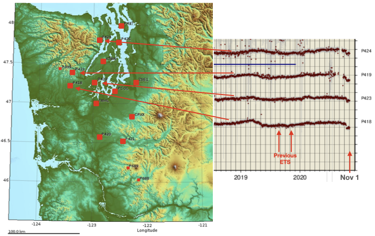
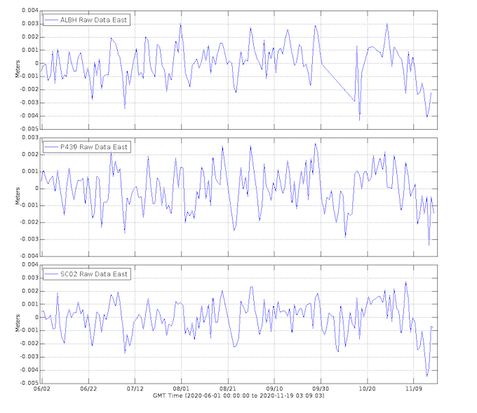
While it is too early to calculate how big this ETS was (and I could not do the calculations to determine its equivalent magnitude in any case) I am suspecting it will be a full sized ETS, maybe even the bigest we have had in this area. Ultimately it stretched from about Portland, OR in the south to part way up Vancouver Island in the north and lasted over six weeks. I'll wait a few days and generate some summary plots for the whole shebang. In the mean time here are plots of time versus displacement for the east-west component of three GPS stations in southern Vancouver Island. By now we can probably see all the displacements taking place as the ETS went under these stations from about Nov. 4 to Nov. 14. While pretty noisy this seismologist would guess there is about 3 mm of offset during this period.
Feb 1, 2021 - Sorry! I previously wrote that I would be doing a summary of this whole ETS event. What with being out of the country, crazy weather, crazy pandemic and just plain “no excuse because I am retired” I have not gotten around to doing such a summary. BUT, for the past week something has been going on in the ETS area so I better add to this blog now.
Starting on about Jan. 26, 2021 tremor started showing up in south-central Vancouver Island and got stronger and longer over the next few days. This burst does NOT look to be a typical inter-ETS tremor patch that is usually down-dip (east-northeast) of the main ETS patches and lasts no more than a few days. This latest batch seems to be a reactivation of part of the standard ETS region. It seems to have started in the region on Vancouver Island that had some of the earliest tremor during the Oct 4 - Nov 16 ETS event, a burst going from Oct 15 to 17. I had expected that this latest burst might migrate north-west to fill in an area that has not had significant tremor since a short burst in Jan-Feb of 2020. However, up until today it seems to be slowly moving south-east back into an area that had significant tremor a few months ago. But this afternoon tremor started lighting up the northern part of this patch and so maybe ultimately it will have some that continues on to the northwest. Stay tuned.
There is no question but that it seems what used to be a fairly standard 14 month ETS that covered similar areas is breaking into different patches that cover the same general area but scattered out in time. I don’t think that this has any significance for hazards or changes in tectonics. We have been monitoring this sort of activity for less than two decades; a short period over the 300+ years since the last major earthquake. We really don’t know what variations to expect over decade periods of time. Our general conclusion is that over periods of years most (all?) sections of the Cascadia subduction zone see slow slip (ETS) events in the subduction fault zone down-dip of the locked zone. Details on time scales of months two a couple of years probably have no significance….. but are fun for this observer and other tremor geeks to look at.
Speaking of tremor geeks; expect to see a new version of the wech-o-meter show up on our tremor page soon. The look and feel will be the same as the current one but the detection-location engine behind the tremor catalog has undergone some significant tweaks to make it more robust to data glitches and outages and more reliable. It is being used to reprocess all original seismic data going back to Jan 1, 2017 and the resulting catalog is being compared to the current catalog and the legacy catalog for quality and reliability. More detailed information will be posted when it is ready to go live.
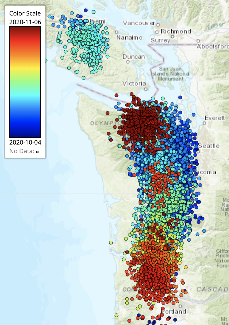
Feb 13, 2021 - OK, this second batch of tremor that covered lower Vancouver Island is now over. Rather than doing as I previously suggested the tremor that started in late January did NOT migrate north to fill in an area that has not had tremor recently, but rather slowly moved south not stopping until it reached the southern end of Vancouver Island. Here is the plot of tremor for this period color coded by date (blue- earliest, red- latest).

A few days ago I was confused that this batch seemed to be going right back over the same area that was involved back in Nov. 2020. Several other tremor "observers" also noted this with questions about what that could mean. It was too early for another main ETS. My puzzling over this led me to ask the real tremor experts, Ken Creager and Aaron Wech what was going on. Both sent me notes explaining why they didn’t think that this was all that unusual and, in fact similar reversals with over-lapping tremor areas have occurred in the past. Aaron even went so far as to “predict” on Feb 9 that this batch would stop within two days…. and nailed it. I should probably retire and try and get Aaron to write this tremor blog. While he might have more ‘luck’ in forecasting trends he certainly would not be able to wax on and on and on with as much boring blabber that I have been want to do.