ETS Event of Winter 2022-2023
Shortcuts:
Main Tremor Index | Interactive Tremor Map | Compare Maps | PANGA geodesy plots
Blog for ETS of Winter 2022 - 2023
This BLOG-like page is being generated in a form similar to previous ETS ones to document and provide information on a Northern Washington - Southern Vancouver Island (NW-VI) ETS. The UW has no special experiments in the field for this ETS; however other groups may have interesting observations that can be reported here if authorized. We will be tracking and reporting on this ETS using data only from the real-time regional networks (UW, UO, CN, PB, CA) and/or information reported to us by others.
Produced by Steve Malone, PNSN Professor Emeritus
ETS dates:
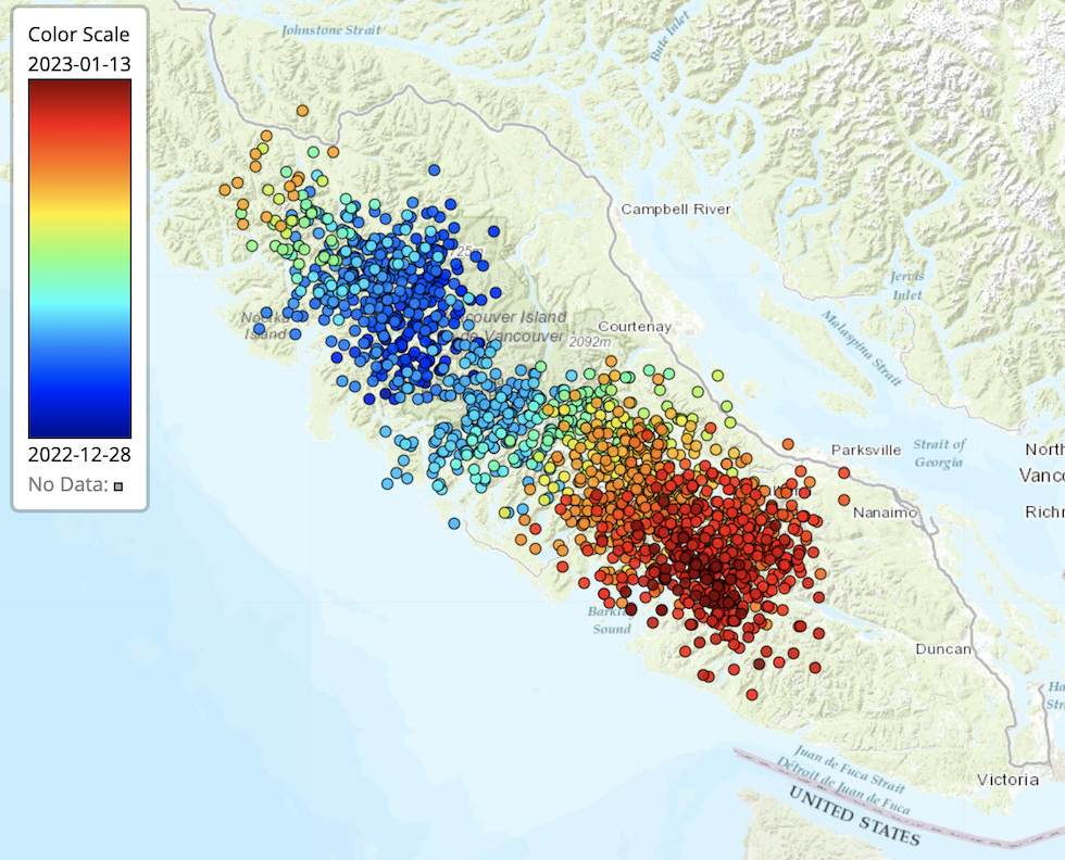
Start: Dec 30, 2022 - END: Jan 12, 2023 (Central Vancouver Island section)
Start: Apr 4, 2023 - END: Apr 25, 2023 (Southern Vancouver - Northern Washington section)
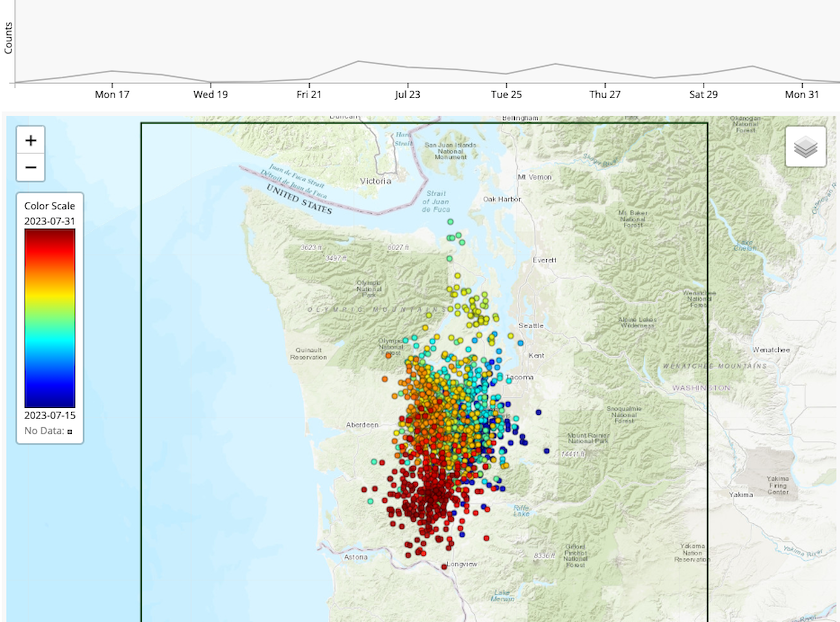
Start: Jul 15, 2023 - END: Aug 1, 2023 (Southern Washington section)
Information will be posted on this page (latest at the bottom) and references to figures from time to time.
NEWS (latest is at the bottom):
Jan 12, 2023 - Recent ETS sequences have NOT followed a similar pattern that was common from around 2006 until 2017. For many cycles the area involved was similar and they occurred at about 14 month intervals. In the past two cases the over all area was broken up into at least two segments that were active at different time, the most recent almost 5 months apart. So, what could we expect to occur next? I would have figured that the Washington (WA) segment would have gone first followed by the Vancouver Island (VI) segment some months later. Nope, maybe it's the other way around.
We now seem to be in an ETS period of, at least the central VI segment. It started about Dec 30 and after a few days seem to be moving in a normal pattern to the south-east. Some periods during the following days had very strong tremor. By Jan 12 it had progressed to within ~100 km of Victoria. Below is a map with color coded (blue - early, red - most recent) tremor locations. If it were to continue as many of the sequences of a decade ago did it will pass into Washington in about a week. However, the last few days have seen fewer and weaker tremor bursts and so who knows what is next.
Of course the current sequence may not be related to the "normal" 14-month WA-VI ETS but rather part of the less regular and smaller ETS events in northern and Central VI. If so then it seems to me that the main "normal" WA ETS is late. It has been 15 months since the Washington part went (Sep 22, 2021 - Oct 11,221) and the southern VI part would be quite early (Mar 20, 2022 - Apr 6, 2022). In any case we will try to keep this blog post reporting and guessing on what comes next.
Jan 14. 2023 - As usual, as soon as I say an ETS is going and could do blah blah, it stops. This sucker played me for a sucker. While it lasted just long enough to get one's hopes up that it would do the whole zone it seems to have just been fooling with me. Of course I could arm wave that it was a bit too far north to be part of the main zone or could wave about it being too soon to be part of a 14 month cycle but my arms get tired very quickly with such excuses. It comes down to the fact that this retired seismologist (along with everyone I know) just doesn't understand what the heck any of this means.
That all being said I need to recognize some comments from tremor watchers out in the Internet world and do some more arm waving in response.
B Good asks the question regarding my above comment about it being 15 months since the last Washington ETS: "I'm curious why the May/June 2022 activity in WA wasn't an ETS." Good question. The answer is, maybe it was a small one. However, the period of sequential days with well located tremor in more than one hour lasted only a week (May 21 - May 28). Indeed there were bursts of tremor in this general area before and after those dates but my arbitrary cut off for being a full blown ETS is two weeks of tremor every day in a row. Another observer, J. McBride notes that there was "initiation" activity on Dec 28 and 29 that started or was part of the sequence. My answer is, yes, maybe but again my arbitrary cut offs don't include those very short bursts nor other small variations in location or timing. Always keep in mind my interpretations and arbitrary start and stop times are my personal arm waving. I could argue that the better science is being done by those of you asking the good questions.
However, to continue arm waving perhaps a better way of looking at the recent distribution of tremor over the Washington - Vancouver Island part of Cascadia is a plot of the latitude of tremor locations versus time for the past six years provided by Prof Creager a few days ago. The latitude of Victoria on the southern end of Vancouver Island is about 48.5 degrees so if any of the recent tremor bursts in this whole area could be considered a regular 14 month ETS then the one from Mar. 19 - Apr 7 (red label 278) from southern to central Vancouver Island could be considered it. Maybe the pause from Apr 7 to Apr 20 when the Washington segment had a week's worth of strong tremor represents a segmentation that indicates lumping Vancouver Island and Washington together as not appropriate.
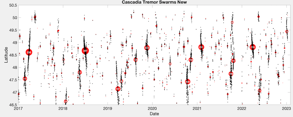
Note that it is almost exactly 14 months from the previous large tremor burst at this latitude (red label 397). If this is the case then the next "real" ETS (14 month cycle) is not due for another 3-4 months and maybe the Washington segment some time after that. By the way, the original 14 month interval first noticed by Herb Dragert and Garry Rogers over 20 years ago was defined by the tremor and GPS displacements observed only in southern Vancouver Island. It was only with improved monitoring and location techniques in subsequent years that associations of the Washington segment with the original observations were made. It seems these associations maybe be less strict than we have assumed and Washington is on a slightly different schedule.
A different way of plotting the time sequence would be to select a thin east-west strip of tremor locations and plot the tremor rate in that strip over time. Below are two such plots aligned in time, the top for the a slice just north of Victoria, BC and the bottom just south of Seattle, WA.
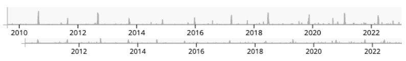
It is obvious that tremor rate in the Victoria slice is higher than in the Seattle slice and that the tremor periods line up very well for the first few years but not so well more recently. Perhaps my past assumptions of lumping VI and WA together is inappropriate and the international border is more than just politics. More likely as the wise Dr. Aaron Wech (of the wech-o-meter) once alluded to, "tremor and slow slip are manifestations of the same thing and will eventually fill all parts of the Cascadia subduction zone and the minor time variations in sequences is nothing compared to the over all sequences of great earthquakes."
However, fool that I am, I will stick my neck out and "predict" that the next southern VI ETS will start on May 20 at 2pm ( plus or minus some months), and the northern WA one sometime around that time too.
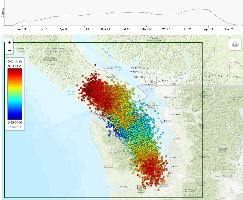
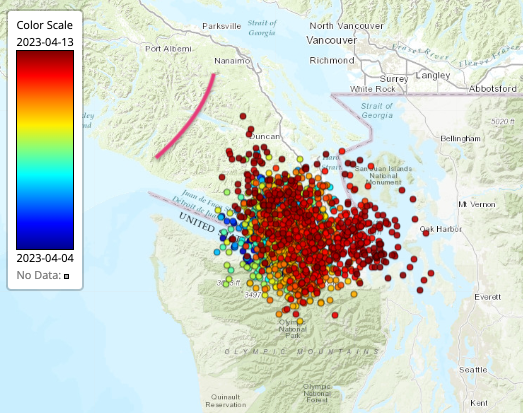
Apr 12, 2023 - It has been three months since the last burst of significant tremor in the Washington - Vancouver Island (WA-VI) part of Cascadia. The last bit of tremor died out in south central VI on Jan 12, 2023. Starting about a week ago on April 4, 2023 tremor picked up just south of the southern end of VI and after a couple of days of spreading out a little bit it has started moving slowly south. At this point the tremor locations are centered about under Port Angeles on the north coast of the Olympic Peninsula. While only a week into this sequence it may be too early to call it a full blown major ETS; however the strength of the tremor and the fact it is taking place on over most of the hours of each day indicates to me that it is likely the real thing.
Here is a map of this week's tremor color coded by time (blue - oldest, red - latest). I have marked with a pink line the most southerly bit of tremor that ended on January 12. Note that there is a bit of a gap between that tremor sequence and the current one.
The timing and location of this sequence is a bit unfortunate for a planned experiment that has been in preparation for the past few months. A new technology called Distributed Acoustic Sensing (DAS) involves using regular communications fiber optics cable to sense and record vibrations all along the cable providing very high resolution detection of seismic waves. You will find introductory information on this technology in a recent BLOG post by Paul Bodin: How fiber-optic cables can be used for seismic monitoring: A primer.
A consortium of several scientists led by two from the University of Colorado has been trying to make arrangements to use a fiber optics cable near Port Angeles for a DAS recording of tremor. They were having trouble getting the owners of the cable to sign off for letting them use if for a short time, but finally got permission today and have started their data acquisition system as of this afternoon. There are no processed data yet available to determine if tremor can even be recorded by this type of system but we should know more in the coming days. With the tremor now right under the cable we are hoping that missing the past week of tremor will not compromise understanding the sequence. What might be learned from recording tremor with this new technology is unknown but one of the fun things about science experiments is you often don’t know what you will find until you start looking with new and innovative methods. Stay tuned for updates as they become available.
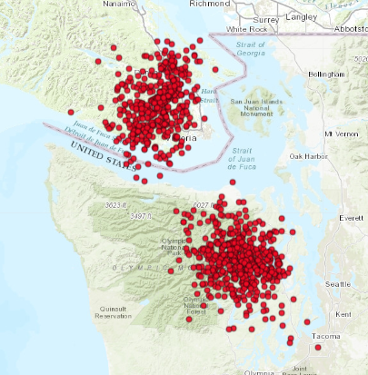
Apr. 17, 2023 - After just a few days centered under Port Angeles the tremor has moved away. In fact it seems to have split with a patch moving back to the north and another moving south into Washington. Below is a map of the locations over the past two days from which it is clear that nothing remains near Port Angeles where the DAS experiment is located. It remains for the data to be recovered and analyzed to determine if this experiment was successful but unfortunately only a couple of days of nearby tremor may turn out to not be enough. We now wait to see if this activity continiues to fill in the normal northern Washington ETS zone that in the past extends to the southern Puget Sound area.
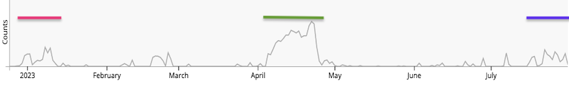
Aug 1, 2023 - I have been busy with lots of other things and while I have continued to watch the tremor via the wech-o-meter over the past several months I have been quite remiss in writing anything up here. One of our public tremor gawkers who is quite experienced in following things has shamed me into finally writing something up. Thank you John McB.
After stopping and starting in different parts of our standard study area it is my conclusion that I don't know what the hell is going on. It seems that the "standard" ETS area going from roughly southern Puget Sound north to mid-Vancouver Island has now broken into at least three sub-zones each going off at different times. I show here a time line for the past 6-months cover tremor locations in our “standard” area. The colored bars represent periods where there was enough tremor to qualify as an ETS and in each case there is at least a hint of geodetic motion to support that interpretation. The batch at the beginning of the year (red) is from the norther section and covered in this blog above. The April batch (green) is partially covered above but continued for over a week after the last post above. The batch in late July (blue) may not yet be over but seems to be dying out. The shorter bursts seen in February and June I have looked at in some detail and determined that this activity consists of much shorter bursts of only a few hundred locations lasting only 2-3 days and mostly down-dip (east) of the main zone. This types of isolated bursts of tremor are quite common over all of Cascadia.