M4.6 earthquake - 2.24 mi NW from Monroe, WA
Event Information
ViewSummary
More information will be available soon.
Maps
ViewWaveform at BHW
ViewShakeMaps
ViewDYFI
ViewRelated Links
Additional Information
Summary
-
Widely felt in greater Seattle area and with some felt reports east of the Cascades and north to the Canadian border. No reports of damage have been recieved.
-
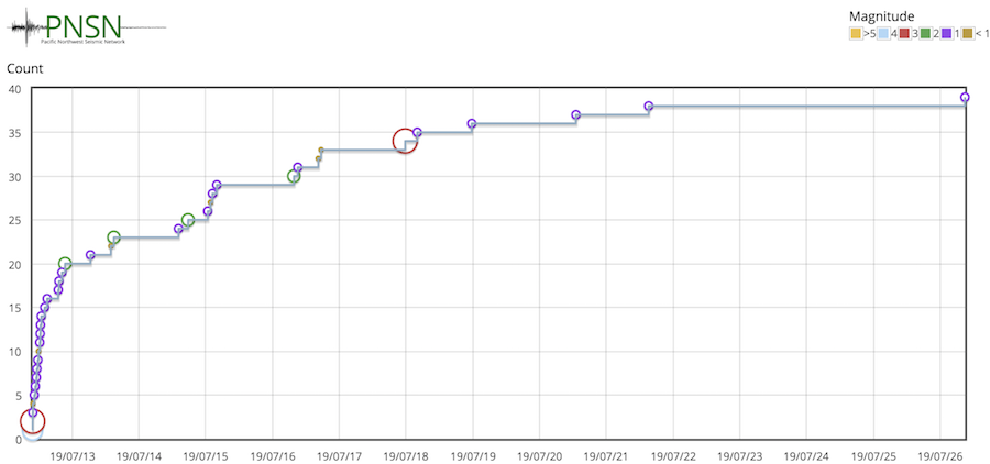
About 17 located aftershocks in the first 24 hours. See below for plot.
-
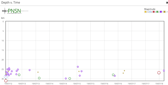
Earthquake deep (~29 km or ~18 miles) and not clearly associated with any particular surface-mapped fault (although close to the Southern Whidbey Island Fault Zone (SWIFZ), Rattlesnake Mt. FZ and an unnamed NE-trending fault zone).
-
In Washington there have been only 2 other earthquakes of larger than this one in the past 10 years: A deep intraslab M4.9 near Poulsbo in the Puget Lowlands in 2009 and an M4.7 near Okanagan in Northeast Washington State in 2011.
-
Strongest recorded Peak Ground Acceleration (PGA) was about 52 gals (cm/s/s) at station UW.LEOT, 15 km from epicenter. This is characterized as light-to-moderate shaking with the potential to, although unlikely to, cause very slight damage.
-
Felt reports from >13,000 (as of 12:30 pm PDT on the 12th). Maximum felt intensities exceeded MMI IV at a few sites close to the epicenter, indicating light shaking.
-
Although not yet a public system, ShakeAlert EEW system released its 1st alert to pilot users 7.8 seconds from Origin Time (M4.4, location 3km from true epicenter). If the ShakeAlert system had been charged with issuing public alerts, Seattle would have received 5-10 s of advanced warning before shaking was felt.
- Careful review of first motions results in a first motion focal mechanisms for both larger events in agreement with the moment tensor generated from regional broad-band data by Bob Hermann; ie: thrust motion on NE-SW oriented fault planes.
Aftershocks
Cumulative number of aftershocks starting with main shock, July 12, 09:51 Z up to July 26 2019 Z.
Time versus event depth plot for the same period.
Tectonic Summary of Area
“Crustal” earthquakes originate from slip on faults within the crust of the North American Plate. Some of these earthquakes reflect stresses that are generated by the convergence of the Juan de Fuca and North America plates but most are related to stresses originating from the interaction of the North American plate and the Pacific plate in California and Nevada. This interaction results in north–south oriented compressive stresses in the crust throughout the western and northern region. These crustal earthquakes occur in the upper 25 km of the earth's crust on faults oriented roughly east–west and northwest–southeast. In southern Oregon, extensional (pull apart) stresses also cause faulting and crustal earthquakes. Many crustal fault zones have been mapped, including the Seattle Fault Zone, the South Whidbey Island Fault, the Devil's Mountain Fault, the Tacoma Fault in the Puget Sound lowlands, and the Spencer Canyon Fault in central Washington. However, not all of the active faults are mapped, and many crustal earthquakes occur on faults that don't reach the Earth's surface. The largest historically documented crustal earthquake was the 1872 M˜7 earthquake near Lake Chelan. Other crustal earthquakes have included the 1993 M5.6 Scott's Mills, Oregon, the 1993 M5.9 and M6.0 Klamath Falls, Oregon, and the 1996 M5.4 Duvall, Washington earthquakes.