Mount Rainier
Mount Rainier is a stratovolcano that started to grow about half a million years ago and has erupted as recently as 1,100 years ago. It is located approximately 90 km SE of Seattle, WA.
The primary hazards associated with Mount Rainier's eruptions are debris and mud flows. In most cases, these flows were triggered during times of eruptions, both as shallow earthquakes shook loose unstable portions of the upper volcano and as hot lava and rock debris melted glacier ice. Mud flows have swept down all of the river valleys that head on the volcano, including an event about 500 years ago that was not associated with any known eruption. Some mud flows have traveled as far as Puget Sound, and much of the lowland between Seattle and Tacoma is formed of pre-historic debris from Mount Rainier.
More information about Mount Rainier from CVO
Background Seismicity
The Cascades Volcano Observatory and the PNSN cooperatively operate 11 seismometers on or near Mount Rainier. In an average month, 3-10 well-located, high-frequency earthquakes are recorded near the summit of Mt. Rainier. In addition, small swarms of 10+ earthquakes over a 2-3-day time period sometimes occur. All of these earthquakes are shallow, with most locating near sea level (~4 km below the summit), and are interpreted by Moran (1997) to be occurring in response to stresses associated with the circulation of hot fluids beneath Mount Rainier. These fluids are thought to be the source for the hot springs and steam vents found at the summit and at various points within Mount Rainier National Park (e.g. Frank, 1995). An additional challenge on Mount Rainier is that its glaciers also produce small swarms of icequakes which have some characteristics similar to volcanic earthquakes. Large rock falls and/or debris flows are sometimes seismically recorded and ice avalanches are not uncommon.
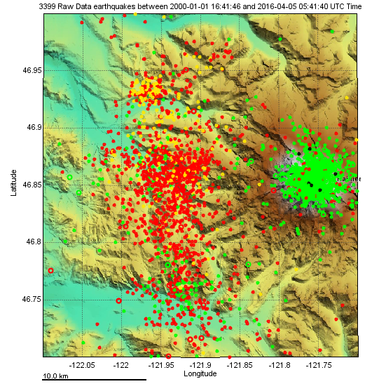
A common source of earthquakes near Mount Rainier is the "West Rainier Seismic Zone" (WRSZ), a diffuse zone of activity running roughly north-south along the west edge of the park. Earthquakes in this zone are thought to be primarily due to regional tectonic stresses rather than to volcanic sources. Below is a map showing epicenters from the past 15 years of earthquakes under the volcano at shallow depth (< 5 km - green symbols) and those in the WRSZ at deeper depths (> 5 km - red symbols) and spread out over a larger area.