Cascadia Subduction Zone Scenarios
Many assumptions are made when generating earthquake scenarios, and nature rarely behaves exactly as predicted. The uncetainties that affect Cascadia Subduction Zone eathquake models include the rupture length, the distribution and amount of slip on the fault, and how far "down dip" the rupure extend. This last aspect of the earthquake is important both for magnitude estimates and because the farther down dip the energetic ruture extends, the closer it comes to the populated I-5 corridor resulting in stronger shaking where the greatest risk resides.
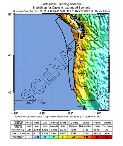
The USGS produced a scenario ShakeMap for a modeled M 9.0 CSZ earthquake for planning purposes. This ShakeMap page provides information about probable shaking levels at different frequencies but is not very useful for site specific estimates nor does it provide much information about potential impacts.
The 1999 24 page Crew Publication, "Cascadia Subduction Zone Earthquakes: A Magniude 9 Earthquake Scenario", takes USGS-model ground motions and NOAA tsunami estimates and paints a generalized picture of the likely damages to regional infrastructure. The scenario then identifes challenges that will be faced in responding and recovering from such an event.
In 2007 CREW produced a publication that summarized potential impacts and lessons learned in three tabletop exercises based on the Cascadia earthquake scenario.
Oregon Department of Transportation examined potential damage to bridges during a scenario M8.3 earthquake on the CSZ.