- Don't Get Scared, Get Prepared!
- Beast Quake (Taylor's Version) (From The Vault)
- Looking at the M3.9 Fall City Earthquake with PNSN.org Tools
- ShakeAlert 2nd Anniversary!
- Pythia's Oasis
- Medford Schools Now Use Earthquake Early Warning Technology - And Yours Could Too!
- Magnitude 4.4 event of Oct 7, 2022
- Join Us in the International ShakeOut Day on October 20
- Undergraduate summer interns get involved with PNSN research
- Exploring exposed subduction zone rocks in the Olympic Mountains
- 2023 5
- 2022 9
- 2021 16
- 2020 5
- 2019 10
- 2018 11
- 2017 10
- 2016 16
- 2015 11
- 2014 16
- 2013 14
-
2012
48
- December 1
- November 2
- October 3
- September 1
- August 3
- July 2
- June 4
- May 4
- April 2
-
March
8
- The wech-o-meter takes over all of Cascadia
- Keystone Cops: Italy prosecutes seismologists for failure to predict deadly quake
- UFOs in eastern Washington? No, rather UTEs (Unidentified Terrestrial Events)
- New Sodo Seattle Liquefaction Array Installed
- Why we should constantly watch the deformation of the seafloor
- Mystery chirp near Newberry Volcano
- Planting seismographs causes earthquakes? or maybe ice-quakes?
- Tunneling rumbles south under Capitol Hill
-
February
7
- 15 years of mostly silent magma inflation near Three Sisters, Oregon
- Mount Hood earthquake swarm of Feb 23, 2012
- Web glitches: duplicate (and even triplicate!) earthquakes
- How earthquake magnitude scales work
- Mine blast masquerades as volcanic tremor
- The Spokane Swarm about 10 years ago
- Another hum around Mount St. Helens
-
January
11
- Slow slip: A new kind of earthquake under our feet
- PNSN and social media
- 3am M3.4 earthquake in St. Helens Seismic Zone
- The wrong kind of volcano noise
- Fast chatter on Rainier an hour ago
- Can slush-mageddon trigger earthquakes?
- Rainier Repeating Earthquakes Update and Comparison with Weather Patterns
- 22-minutes drumbeat icequakes(?)
- Mount Rainier popping away
- Repeating Earthquakes on Mount Rainier - are glaciers the culprit?
- Debunking another SEC football myth by the PAC-12
-
2011
17
-
December
13
- One year ago, Seattle Seahawks 12th Man Earthquake
- The odds this year of a megaquake on the Pacific Northwest coast
- Is the plague of great earthquakes this decade a sign of increased danger?
- Nile Valley landslide talks to PNSN seismologists
- Good vs evil in central US earthquake hazard analysis
- Why does a volcano scream?
- Predicting big quakes from patterns of little ones
- 1-hour warning for Japanese M9 earthquake?
- Sound Transit train under Interlaken keeps a rollin'
- Invisible changes under the hood at the PNSN
- Sound Transit Tunneling Noise
- "Visionary" toads
- Earthquake early warning in the PNW
- November 1
- March 2
- February 1
-
December
13
Just as you might move to new house, spending months picking it out and moving everything, we just switched to new software to drive our earthquake information.
We phased out XPED, written originally only for the University of Washington 20 years ago for slow black and white computers. We brought in AQMS, the new national standard, which used color GUIs (graphical user interfaces) and has hundreds of options. We are the second region after California to bring AQMS on line. Hawaii, Utah, and the Central US will soon follow. Correction: We are the third region after California to bring AQMS on line, Hawaii has been using it for a while already.
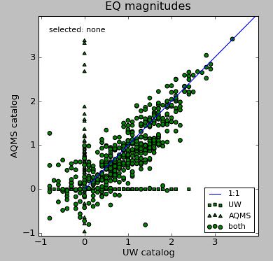
For the past few months we ran both systems together to make sure the answers were right. For example, the measurements of magnitude were done differently. The plot below shows even two correct methods can disagree by up to 1 magnitude unit for the smallest events (ignore those events for which one magnitude is zero).
It's a relief to return to running just a single system. When everything is working, fairly accurate info can be posted as fast as we can look at a couple of plots on our iPhones, so you can benefit as well. You can check the earthquake map now on your smartphone, at this link.
Feel free to pitch in comments, should anyone have noticed this blog yet. It's hard to home in on the hottest topics without hearing whether more or less details, jargon, figures, links, or verbiage is wanted.
