Getting ready for the next Great Cascadia Subduction Zone Earthquake
Getting ready for the next Great Cascadia Subduction Zone Earthquake
January 27, 2020
by Bill Steele
Three hundred and twenty years ago, thousands of coastal residents settled in for the night on January 26th 1700, when suddenly the ground began to shake. For most, the first signs were subtle, dogs laying on the ground barked nervously as the weak “P” or primary wave vibrations passed by. The earthquake became unmistakable when the strong shaking from the “S” (also known as secondary or shear) waves arrived at village after village as the entire fault along the Cascadia Subduction Zone, between Northern California to Vancouver island, ruptured generating fresh seismic waves as the fault continued to unzip for 3-6 terrifying minutes.
This earthquake released about 1500 times more seismic energy than the 2001 M 6.8 Nisqually Earthquake. It can be seen as a connected series of large earthquakes with an average slip of around 20 meters. A significant portion of the rupture occurred on the shallowest portions of the fault and uplifted the seafloor and the entire column of water above it. This great column of water then collapsed producing a series of tsunami waves that would batter the coastline through the night and cross the Pacific basin. Though all people west of the Cascades were disrupted by the shaking and some injured by falling logs and possessions, it was the water that claimed many lives that night when villages were overtaken by tsunami-generated floods.
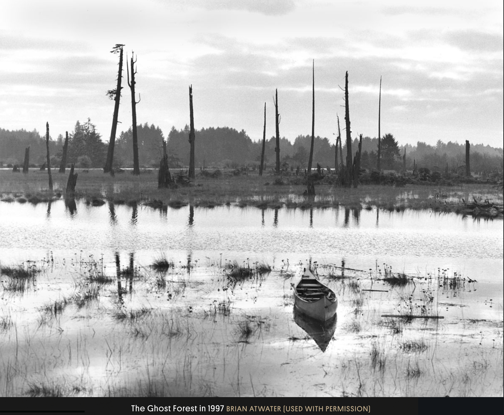
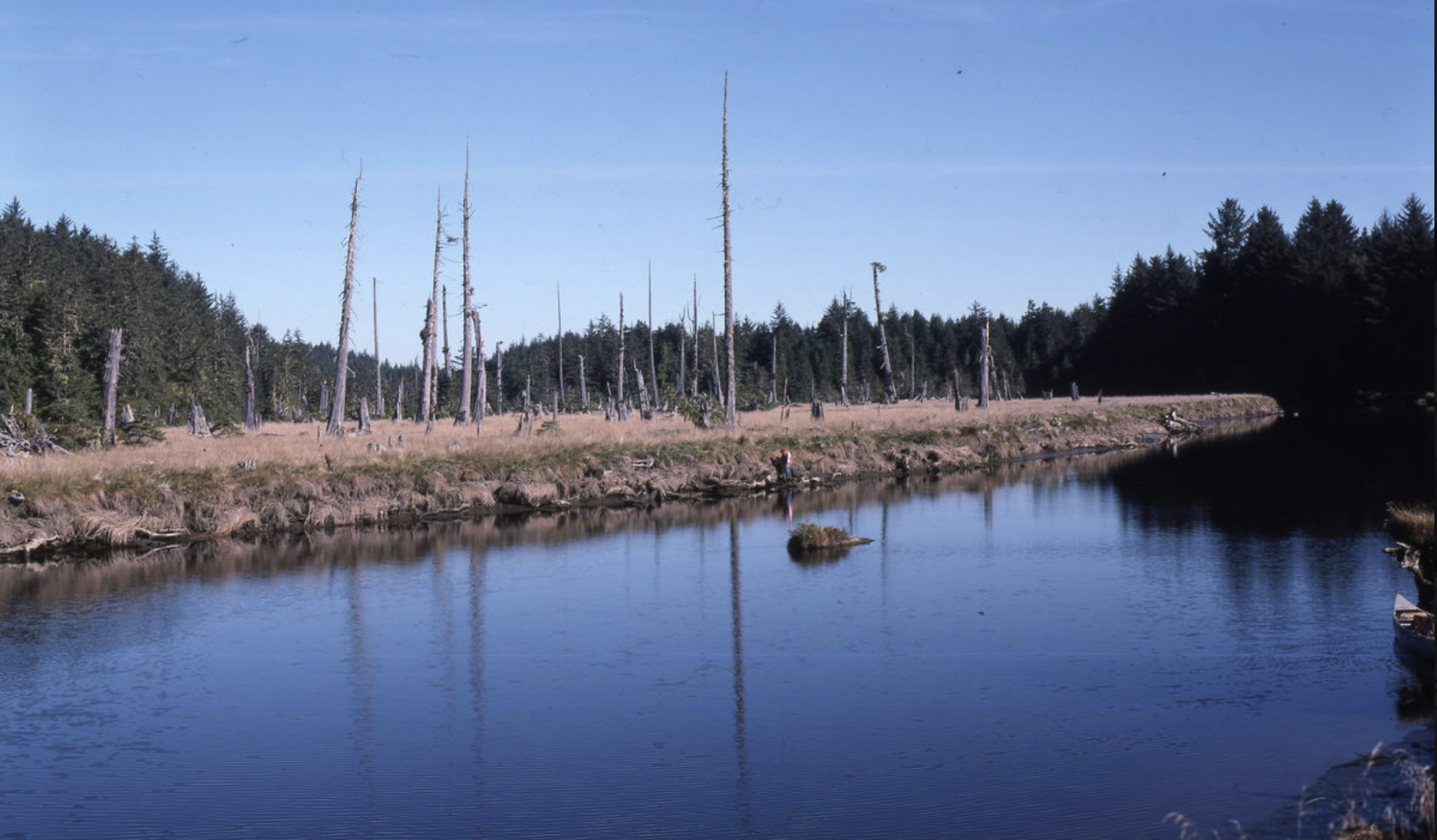
The 1980s were a decade of discovery of evidence for great earthquakes in the Cascadia region. Tom Heaton and Hiroo Kanamori at Caltech published a paper asserting the Cascadia Subduction Zone was indeed actively deforming and is likely to produce great earthquakes. Brian Atwater's 1987 paper in Science provided the geologic evidence in support of these theories that described repeated abrupt co-seismic land level changes along our coast and evidence of wide-spread tsunami inundation following these periodic great earthquakes. Atwater and other scientists continued to work over decades to tease out the details of the 1700 earthquake’s magnitude, shaking levels, tsunami inundation, and how frequently these earthquakes have affected the region over the past 10,000 years. Chris Goldfinger and other marine geologists contributed greatly to this inventory through the collection and analysis of submarine landslide deposits along the Cascadia margin to come up with an average recurrence rate of about 500 years. The recurrence rate for smaller magnitude 8 events along certain portions such as southern Oregon are as short as 200-300 years.
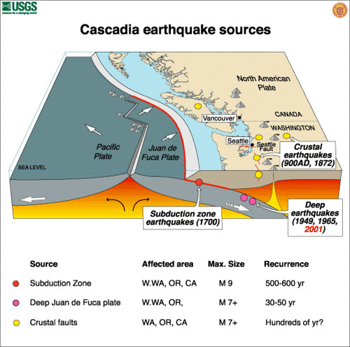
Study of earthquakes in other subduction zones around the world provided the precise date of the 1700 earthquake. We even know that it happened around 9pm local time on January 26 based on Japanese records of the “Orphan Tsunami of 1700" that caused minor flooding on its shores without a felt parent earthquake. The lack of evidence of tsunami since 1700 informs scientists that the fault has been accumulating enough strain over the last 320 years to produce another great earthquake. Though it's impossible to pin down exactly when this next inevitable event will happen, the odds over the next 50 years range from about one in three for an M8 in southern Oregon to about one in eight for an M9 spanning the entire subduction zone.
There have been many examples of subduction zone earthquakes to study over the past 20 years. The most deadly of these, the Mw 9.1 2004 Sumatra-Andaman Earthquake and Indian Ocean Tsunami, that killed between 230-300,000 people in Indonesia and at least 15 other nations. Other great earthquakes occurred over the past 10 years include the 2010 M 8.8 Maule, Chile Earthquake and the Mw 9.1 Tohoku Japan Earthquake of March 11, 2011 in which more than 15,000 people died, over 92% from drowning during the tsunami flooding. The Fukushima Daiichi Nuclear Power Plant had three reactors partially meltdown, displacing over 50,000 people and to this day continues to absorb billions of dollars a year in efforts to contain radioactive and chemical pollution and remove “spent” fuel rod pieces. Cost estimates from the Japanese government for the long term cost of the disaster stretch far beyond $100 billion.
The Cascadia Subduction Zone has remained locked, loaded, and quiet despite all this tumult elsewhere in the world. Though it produced a few small earthquakes within the “locked zone”, none of the larger earthquakes so prevalent in other subduction zones around the world have happened here. Scientists see significant variation in behavior from one subduction zone to the next so while we learn a lot from great earthquakes around the world, there may be surprises when our fault breaks loose again. Despite the natural variations between faults and earthquake effects, some clear conclusions can be made.
Emergency response will be slow, especially in rural and coastal areas. This will be largely due to ground failure, structural damage, and tsunami flooding affecting roadways and bridges. In all areas, especially near the coast, citizens need to be self-sufficient for food, water, and medicine for weeks, not just days. Because of this, Washington and Oregon Emergency Management agencies are urging citizens to become "2 Weeks Ready". Unfortunately, only a minority of households have even 3-day’s worth of emergency supplies on hand. We must encourage our families, co-workers, and neighbors to become more prepared.
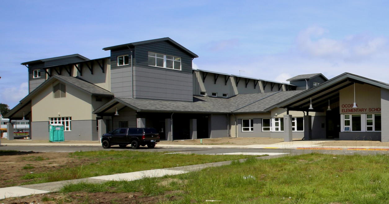
Tsunami Waves are deadly. Many coastal areas have been identified where no tsunami-safe evacuation options are in reach of residents and visitors to the area. Engineering design standards have been adopted and community planning initiated for vertical evacuation berms and structures where high ground is not readily available. Additional support and improved financing options for communities in the tsunami flood plain to construct vertical evacuation alternatives must be developed. Thankfully, work to build examples of safe evacuation options have begun. The Ocosta School District opened its new Vertical Evacuation Structure, Ocosta Elementary School, in June 2016 funded entirely by local taxpayers. The Seaside School District is currently constructing a new campus outside the tsunami zone for all of its students.
In 2019 FEMA produced the 3rd edition of its Guidelines for Design of Structures for Vertical Evacuation. Work at State Geologic Surveys, National Oceanic and Atmospheric Administration (NOAA), and research universities such as UW and OSU have greatly improved the modeling of tsunamis and have mapped likely inundation zones providing critical data for emergency managers to use in the development of evacuation plans and vertical evacuation structure site selection.
The Pacific Northwest Seismic Network, with support from the USGS, the Gordon and Betty Moore Foundation, and the states of Washington and Oregon, is expanding the seismic network. The buildout will more than double the number of instruments in the region in support of the ShakeAlert Earthquake Early Warning System that went live in the region in April 2017. In the event of a large Cascadia Subduction Zone earthquake, we expect ShakeAlert to provide most people in coastal communities tens of seconds to up to a few minutes of warning depending on how close they are to the epicenter. Public alerting via Wireless Emergency Alerts may begin as early as the fall of this year for both Washington and Oregon, a cell phone app also in development in Washington for release later this year. This will allow people to get to a safe place to ride out the earthquake. The USGS currently publishes alerts developed at UW, UO, UC Berkeley, USGS Menlo Park, and Caltech that are captured by dozens of partners piloting loss-reduction actions before dangerous shaking reaches their facilities. Over a dozen water and sewer districts, school districts, hospitals, city and State agencies and other businesses are using these alerts in the region to limit losses.
Functioning water, wastewater, power, fuel, and transportation systems are all requirements for a successful recovery for affected communities. Even critical services such as police and fire departments and hospitals are severely hampered when these critical lifelines are disrupted. The Cascadia Region Earthquake Workgroup is developing a series of two-day symposiums for critical infrastructure managers to explore how they can build “resilience”, the ability to bounce back after a disaster, into utilities planning and investment priorities.
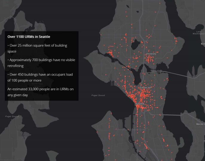
Thousands of vulnerable unreinforced masonry buildings and old brittle concrete structures in cities such as Everett, Seattle, Tacoma, Portland, Medford, and many more are likely to suffer significant structural damage during the next Cascadia earthquake injuring residents and blocking roadways. There are still hundreds of schools that do meet the engineering requirements for minimum life safety. The PNSN supports initiatives in the region to strengthen vulnerable buildings with retrofits or remove them to make way for other development before an earthquake renders them unoccupiable. The states of Washington and Oregon have begun to invest in programs that are helping to retrofit vulnerable structures or to investigate what is needed to make our school buildings safe. Still, much more investment is needed from both state and local resources. Legislatures in the region should also consider setting minimum building safety standards for schools and other facilities for vulnerable populations with timelines and deadlines for when retrofit work must be accomplished or the building removed.
These are a few projects that could be well underway before the end of the decade and would have a big impact on the Cascadia region's resilience and ability to recover from our next great earthquake. There could be many more. The important task is to keep moving forward and continuing to invest to provide future generations with the tools and a culture of preparedness to thrive in the Pacific Northwest.
Additional Resources:
Learn more about Cascadia Subduction Zone earthquakes and tsunamis on PNSN’s website.
Please also visit our PNSN facebook page and the PNW Earthquake Hazards discussion group.
CREW, the Cascadia Region Earthquake Workgroup was organized in 1992 by business leaders, scientists and public sector agencies wanting to work together to reduce our exposure to losses from the next great Cascadia Earthquake. CREW believes that mitigation and other risk reduction measures can be cost-effective methods of reducing losses of life and property and greatly speed economic recovery. Over the last twenty years CREW has organized conferences, workshops, forums and numerous projects in partnership with FEMA, state and provincial governments, businesses and non-profit organizations throughout the Cascadia region which extends from northern most California to northern British Columbia. These activities have increased awareness of the hazards and reduced risk of losses but much more work needs to be done before our Cascadia Subduction Zone breaks free again. A Cascadia Earthquake Scenario is available on the CREW website.
Other information:
Washington State School Safety Project
Oregon Schools Seismic Safety Project
Project SafeHaven Vertical Evacuation Planning
ShakeAlert Technical Implementation Plan