Big Snow Avalanche at Mount St Helens
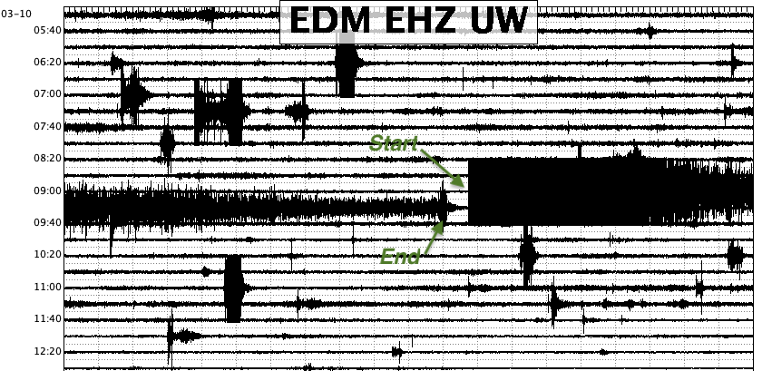
A very large and long-lasting signal in the very early morning hours of April 10, 2011 on the seismograms from station EDM on the east flank of Mount St. Helens got our attention the following day. Because of the way it was recorded on stations near the volcano and farther away we suspected it had to be a surface type of an event. C. Dan Miller of the Cascade Volcano Observatory flew up for a look and to take photographs, and he confirmed there was a large avalanche. After analyzing the seismograms and some of the photos that Dan kindly provided to us we think we, at least qualitatively, understand what happened. Here is a portion of the seismogram from station EDM with the start marked at 09:12 GMT (1:12 am PST), and end of the avalanche signal is marked almost 20 minutes later. Each line is 20 minutes long. The shaking from the passage of this avalanche was so strong that it saturated the electronics of the EDM station for almost four minutes. Other much smaller events are also seen on this seismogram which are probably much smaller avalanches or rockfalls.
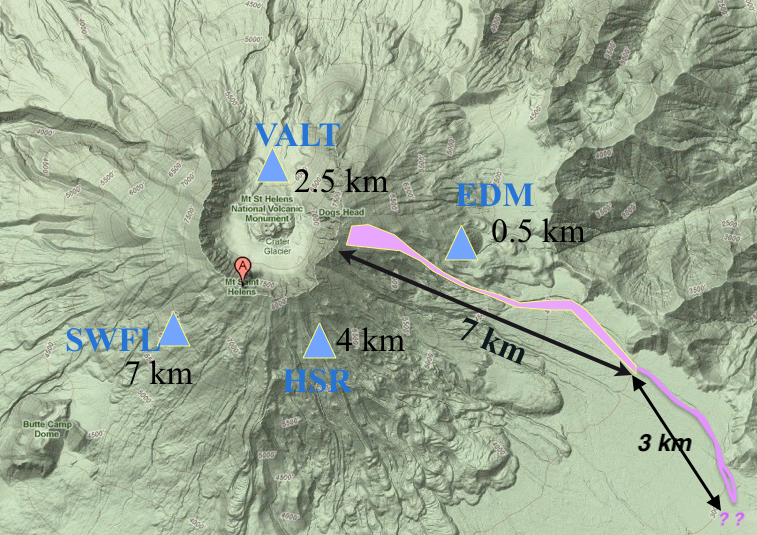
The relief map shown below indicates in pink the approximate area of the avalanche (determined from Dan’s account and photos. See below) that started just below the crater rim and traveled as a pair of slab avalanches rapidly down the steep upper slopes passing within 1/2 km of the seismic station, EDM. As it reached the more gentle slopes of the Plains of Abraham it slowed considerably transitioning into a very wet, watery flow that continued on at much slower speeds. As it lost energy, and perhaps water content, it at some point suddenly stopped leaving elongated features of frozen ice. Some of our seismograph stations are indicated as blue triangles with the approximate distance from the steepest part of the avalanche indicated.
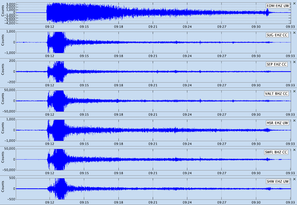
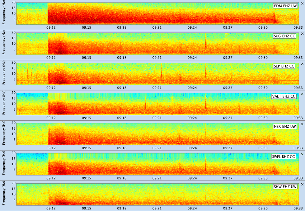
Below is an expanded view of about 28 minutes centered on the time of the avalanche for 7 of our seismic stations followed by a plot of spectrograms for these same stations. In both the seismograms and spectrograms one can see that there were two bursts, separated by about 20 to 30 seconds, of high amplitude energy near the start. From photos (see below) one can see that there were two distinct source regions. Thus one might hypothesize that one of these regions had a spontaneous initiation, and that once that mass of snow had traveled down hill to where the topography joined the nearby area, it triggered the second source zone. The strong shaking lasted about 1 1/2 minutes as this large snow mass accelerated down the steep slopes. The signals then rapidly weakened and then continued to gradually decrease over the next 18 minutes. We can estimate velocities of this avalanche from these observations. If we assume that the steep part of the descent was about 3 km long, and then the rest of the flow went for another 7 km, we come up with average velocities of about 120 km/hr (75 miles/hr) in the upper part and an average of 23 km/hr (14 miles/hr) for the lower, flatter part. These velocities seem very reasonable to me, and the slow speeds during the lower part indicates it was a very wet avalanche. Something strange happened at the end where one can see on the seismograms, but even better on the spectrograms, a short burst of energy just before the signal died away to background levels. This stopping signal is hard to understand unless one assumes that a large part of the flow stoped all at the same time.
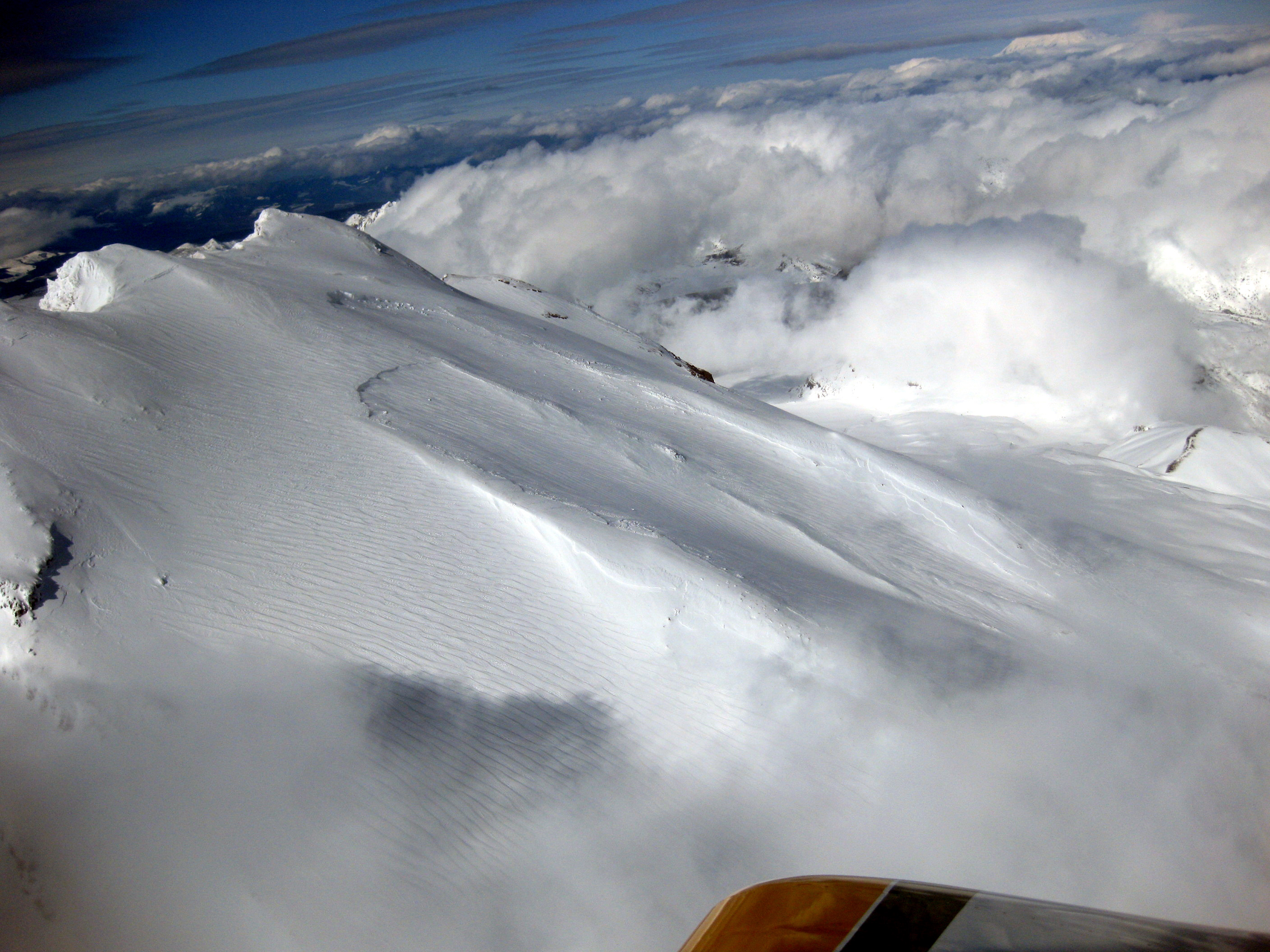
The following are a few of the photos that C. Dan Miller kindly provided to us to help us understand the seismic signals. (clicking on any photo will provide a higher resolution version) Here is a photo of the start zone where one can clearly see the two different fracture lines that are estimated to be several meters high. It is also obvious that some snow drifted into this area subsequent to the avalanche.
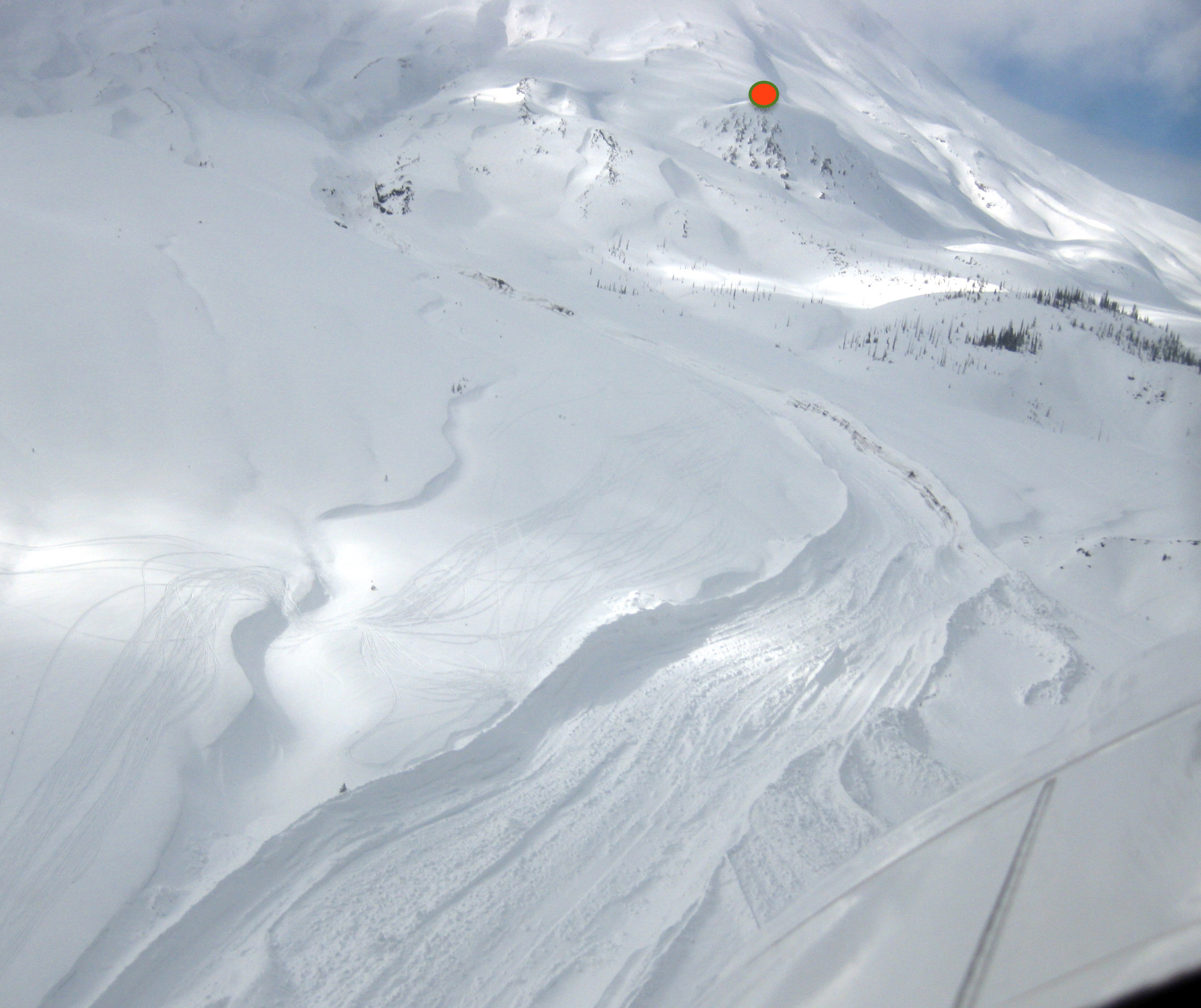
Here is a photo from a low altitude just above the lower part of the avalanche looking back up toward the mountain. The red dot is at EDM, “East Dome”. Also, note in the middle foreground to the left of the avalanche path there are tracks of snow machines.
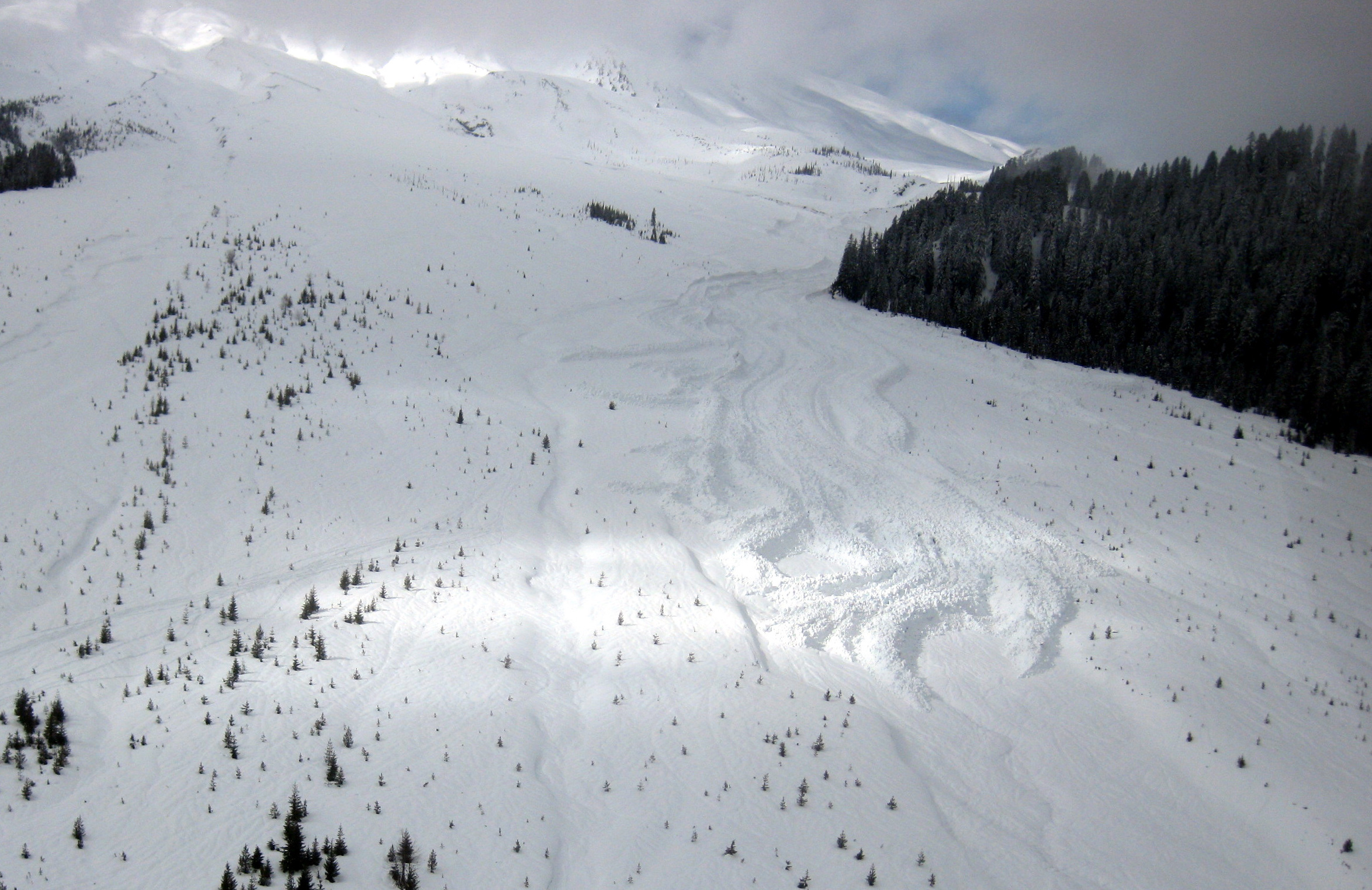
Here is a photo taken from a low altitude from past the end of the avalanche looking back up hill. Note the very pronounced levies on the sides and even in the middle and the blocks of snow/ice sitting on the tops of these levies. This sort of morphology is very common in the debris field of wet snow avalanches.
See our "Exotic Events" web page for a list of many other seismically recorded avalanches and other strange things that go bump in the night.