Magnitude 4.4 event of Oct 7, 2022
This morning (Oct 7, 2022) while comfortably asleep a little before 6am, my phone and the “Duty Pager” for the Pacific Northwest Seismic Network (PNSN) started beeping and buzzing with information that an earthquake of magnitude 3.9 had taken place in central Oregon. With blurry eyes (and no coffee), and since I was the Duty Seismologist, I jumped on my computer and was able to confirm that it was a reliable notification and so an official release to the public within seven minutes but with a magnitude of 4.4, significant enough to be fairly widely felt. My co-duty-seismologist Nicholas and I followed our standard procedure of notifying the relevant state Emergency Management organization and checking that all of our web products were being properly published both on our web page and the USGS one. This event is the largest earthquake to occur in our authoritative region (Oregon and Washington) since a Mag=4.6 on July 12, 2019 near Monroe, WA and the second largest in over a decade.
Basic event parameters:
Time: Oct. 7, 2022 at 05:52:36 PDT ( 12:52:36 UTC).
Location: 44.54 North, 122.55 West, depth of 13.2 km (8 miles) ~24 km (14 miles) East of Lebanon, OR.
Faulting mechanism: Thrust fault on a fault striking NE-SW either dipping steeply to NW or less steeply to SE. Consistent with horizontal major compressive stress oriented NNW-SSE. There are no mapped faults in this area according to the Oregon Department of Geology and Mineral Industries
Felt area: Generally throughout the Willamette Valley from just north of Portland, OR to south of Eugene, OR with a few reports east of the Cascades and out on the coast. The strongest reported area is just west of the epicenter in and around the town of Lebanon with a Modified Mercalli Intensity of IV.
ShakeAlert: The USGS Earthquake Early Warning System called ShakeAlert worked just as it should for this event. It produced a solution very close to the final one produced by the PNSN at 8.8 seconds after origin time. However, alerts were NOT sent out because it did not exceed the alerting thresholds of Mag > 5.0 for WEA alerts or Mag > 4.5 for specific phone-apps. This is as it should be since this event was not large enough to do any significant damage.
Aftershocks: There have only been 7 very tiny (Mag < 1) aftershocks of this event in the first day. This is not unusual for earthquakes of this size and depth in western Washington and Oregon.
Not to air our dirty laundry but not everything in the PNSN system for recording and reporting information about earthquakes worked as well as it should have. To start with our automatic system notified us seismologists via pagers that the earthquake had just happened but did not put out an immediate notification to those outside the PNSN. Some of the location error estimates were not initially good enough for the computer to generate an automatic public release. This is a known issue that is being worked on to improve. Also, our ShakeMap needed some extra help to properly run and even then it took much longer than it should have and the resulting static image displayed on our website have color problems. This too is a known problem and being worked on. On the bright side the display of our ShakeMap by the USGS looks very good and illustrates just how well this earthquake was both recorded by instruments and reported felt by people.
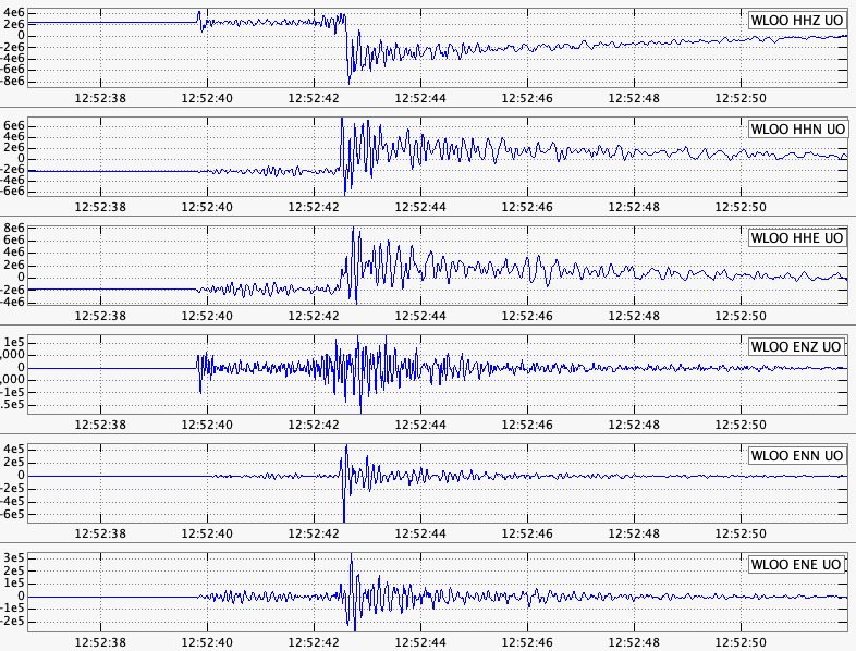
An interesting observation about the seismograms from this event can be seen in the following figure showing the broad-band channels (top 3 labeled: HH?) and the strong-motion channels (bottom 3 labeled: EN?) from station WLOO located only 15 km from the event epicenter. The shaking was so strong that it put the broad-band channels outside their normal operating range causing the big off-set in their traces at the time of the S-wave arrival. The strong-motion channels stayed properly on scale allowing for the accurate recording of this event. This is an example of why many of our modern seismic stations have both broad-band (most sensitive and accurate for weak-motions) and strong-motion channels (stays accurately on-scale even for very strong shaking).
There are many questions seismologists are asked after such an event but they all can be reduced to “what does it mean?”. We don’t know what fault this event took place on but there are many un-mapped faults, either because they are very difficult to find or they do not break the surface where they could be found. An earthquake of this size typically has a fault rupture area no more than one to two kilometers on a side and at a depth of 13 km would not have any surface rupture. While we can’t point at any specific causative fault we can say this event is totally consistent with other earthquakes in the region and due the common stress field of roughly north-south compression. For example, the Scotts Mills earthquake (sometimes called the “Spring Break quake”) of magnitude 5.6 on March 25, 1993 and located over 40 kilometers due north of today's event was also a thrust type earthquake on a fault striking in this case more east-west and at only a slightly deeper depth (15 km). In this case an extension of the mapped Mount Angel Fault is thought to be the causative fault though there was no surface faulting found caused by the earthquake.
So, a north-south compressive stress in the crust of western Washington and Oregon seems to be common to many (most) such earthquakes even the many more smaller ones. But wait a minute. Plate tectonics says that the off-shore Juan de Fuca plate is squishing coastal North America in a more east-west (or at least East-North-East) direction so should not the causative stress for earthquakes like today’s be more E-W? I’m glad I asked because this apparent paradox is one of many interesting aspects of our geology and tectonics. An arm waving explanation can invoke timing and strength. The subduction zone fault along our coast is comparatively weak and the stresses that build up on it are relieved fairly often (if every few centuries can be considered “often”). On the other hand, crustal faults are comparatively strong and there are many of them and they fail, at least in a big, major stress-relieving event, very rarely, maybe only once every few millennia. Thus these two fault systems are very different.
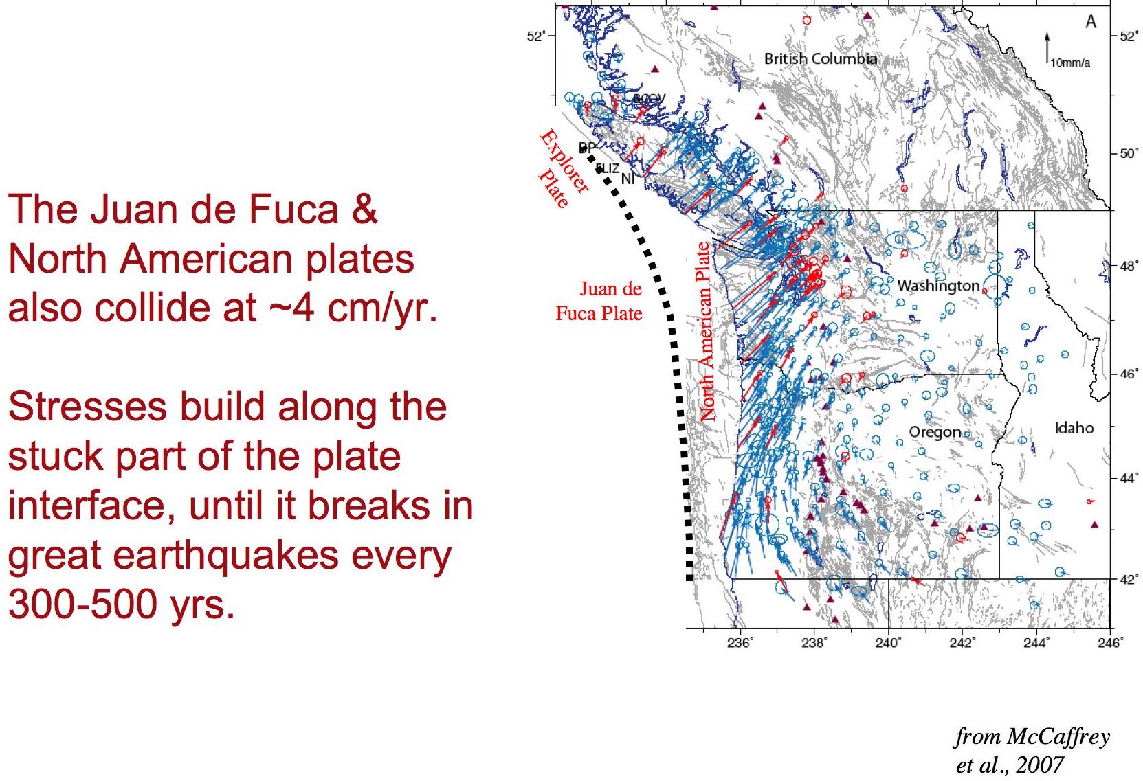
So, where does the north-south crustal stress come from? We can blame it on the Californians and the Canadians. Actually geodesy helps a lot. The figure below (from Rob McCaffrey) shows the motions of the Pacific Northwest relative to stable North America (far inland) as determined by years of GPS measurements at many sites The longer the vector the faster the motion. It is obvious in this figure that the largest vectors are along the coast and pointing in the north-east direction, pretty close to the same direction that the Juan de Fuca plate is slamming into us. The shorter vectors to the east means that the crust is being shortened in the in-between region; ie building up stress.
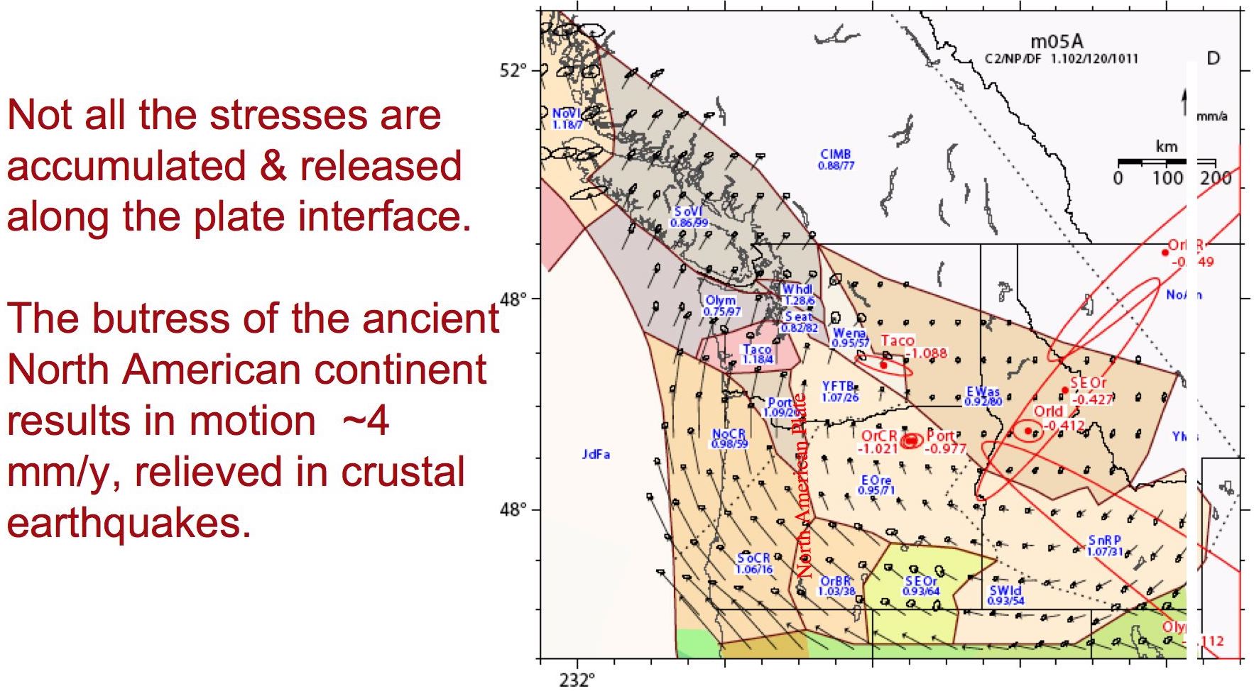
The above figure shows the actual recent (geologically speaking) measured motions. However, if you subtract out the motions just due to the squishing of the Juan de Fuca plate you get the resolved motions shown in the following figure. So these remaining motions are because California is moving north but the speed is ten times slower (4 mm/year rather than the 4 cm/year due to subduction). The problem is that Canada east of Vancouver, BC is not moving. So we are being squished in a north-south direction between California and Canada. Thus crustal earthquakes such as today’s have little connection to the “Big One” that will eventually happen along our coast. Similarly it is unrelated to the deep tremor associated with the Episodic Tremor and Slip (ETS) motions that take place all along the Cascadia subduction zone every few months to a year or so.
The question remains, what next? This earthquake does not mean that the “Big One” is now imminent. Of course, it does not mean that the “Big One” is NOT imminent. In other words it is irrelevant for saying what comes next.