- Understanding Earthquake Numbers
- Mount Rainier earthquake swarm of July, 2025
- Bob Crosson has passed away
- Tonasket Earthquake Swarm or Aftershock Sequence?
- M4.5 Earthquake at Orcas Island, Washington, March 3rd, 2025
- 2024 PNSN Earthquake Catalog
- Rumblings: Preparing for Cascadia - Documentary Screening and Discussion
- 'N Yo' Seismic Network: Marshawn Lynch Shakes the PNSN!
- Swarms in Eastern Washington: are there fewer now than in the past?
- New Algorithm GFAST Enhances the ShakeAlert Earthquake Early Warning System
- 2025 7
- 2024 3
- 2023 5
- 2022 9
- 2021 16
- 2020 5
- 2019 10
- 2018 11
- 2017 10
- 2016 16
- 2015 11
- 2014 16
- 2013 14
-
2012
48
- December 1
- November 2
- October 3
- September 1
- August 3
- July 2
- June 4
- May 4
- April 2
-
March
8
- The wech-o-meter takes over all of Cascadia
- Keystone Cops: Italy prosecutes seismologists for failure to predict deadly quake
- UFOs in eastern Washington? No, rather UTEs (Unidentified Terrestrial Events)
- New Sodo Seattle Liquefaction Array Installed
- Why we should constantly watch the deformation of the seafloor
- Mystery chirp near Newberry Volcano
- Planting seismographs causes earthquakes? or maybe ice-quakes?
- Tunneling rumbles south under Capitol Hill
-
February
7
- 15 years of mostly silent magma inflation near Three Sisters, Oregon
- Mount Hood earthquake swarm of Feb 23, 2012
- Web glitches: duplicate (and even triplicate!) earthquakes
- How earthquake magnitude scales work
- Mine blast masquerades as volcanic tremor
- The Spokane Swarm about 10 years ago
- Another hum around Mount St. Helens
-
January
11
- Slow slip: A new kind of earthquake under our feet
- PNSN and social media
- 3am M3.4 earthquake in St. Helens Seismic Zone
- The wrong kind of volcano noise
- Fast chatter on Rainier an hour ago
- Can slush-mageddon trigger earthquakes?
- Rainier Repeating Earthquakes Update and Comparison with Weather Patterns
- 22-minutes drumbeat icequakes(?)
- Mount Rainier popping away
- Repeating Earthquakes on Mount Rainier - are glaciers the culprit?
- Debunking another SEC football myth by the PAC-12
-
2011
17
-
December
13
- One year ago, Seattle Seahawks 12th Man Earthquake
- The odds this year of a megaquake on the Pacific Northwest coast
- Is the plague of great earthquakes this decade a sign of increased danger?
- Nile Valley landslide talks to PNSN seismologists
- Good vs evil in central US earthquake hazard analysis
- Why does a volcano scream?
- Predicting big quakes from patterns of little ones
- 1-hour warning for Japanese M9 earthquake?
- Sound Transit train under Interlaken keeps a rollin'
- Invisible changes under the hood at the PNSN
- Sound Transit Tunneling Noise
- "Visionary" toads
- Earthquake early warning in the PNW
- November 1
- March 2
- February 1
-
December
13
This jokulhlaup was not detected until several days after it occurred. There is a very complete description of this event and investigations into the deposits and source at the Mount Baker Volcano Research Center web site. Here we describe the seismic data for this event which, unfortunately is somewhat limited because there are few seismic stations in the area.
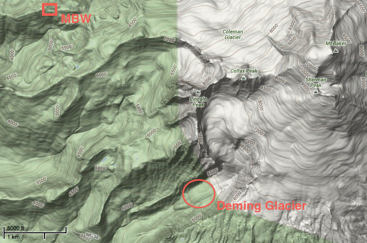
Seth Moran of the Cascade Volcano Observatory called our attention to this interesting seismic record after hearing of a turbidity spike in a stream monitor on the Nooksack River. The classic signature of a lahar can be seen on the attached seismogram and spectrum. In this case there is a relatively sharp and larger start to the signal, probably due to a sudden fall of ice or break off of a large ice block. Note that on the spectrogram the signal is fairly broadband with fairly strong content from less than 1 Hz to over 15 Hz. It lasts at a pretty constant level for over 6 minutes and then gradually declines over the next 10 to 15 minutes. Signals very similar to this have been seen on Mount Rainier seismic stations several times in the past 25 years. The attached map illustrates the relative locations of the probable source area on the lower Deming Glacier and the MBW seismic station.


