Negative depth earthquakes?
A few small changes in our processing and reporting of earthquakes are now taking place. Besides minor changes in event classification parameters (not seen on the web page listings) we are changing the datum used for calculating depths of earthquakes. In the past all earthquakes had positive depth which meant the distance down into the earth from the average nearby station elevations. Thus the reference datum was always changing depending on what stations were used to locate an earthquake. If an earthquake directly under Mount St. Helens had a reported depth of 0.5 km that meant that it was actually located 1.5 km above sea level since the nearby stations used to locate it have an average elevation of 2.0 km. This was confusing to many (including some of us) when trying to interpret the meaning of shallow earthquakes.
We are now starting to report all future earthquake at a depth relative to sea level (officially this is called the Geoid depth). This is being done by simply subtracting the average station elevation of the five nearest stations. Thus if the calculated depth is less than this average the result is a negative depth. So, a negative depth means "above" sea level.
All of our previous events will soon be converted to this new way of reporting. We will not be relocating all the events, just subtracting the average nearby station elevations from each calculated depth and replacing the previously reported depth with this new number.
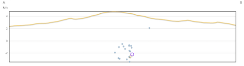
Below is an example of a cross-section of some recent earthquakes located under Mount Rainier. One of these has just been relocated with this new reporting of negative depths. Note that it is up in the mountain at an elevation of just over 2 km. The other events plotted here have not had their depth's adjusted yet and so will likely plot up in the mountain also once that conversion is complete.
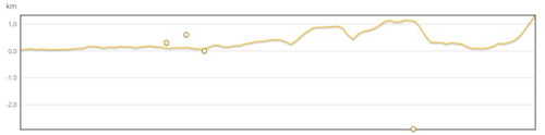
Because of the rough terrain in parts of the PNSN region and errors in depth calculation or the average station elevations being above the topography where an event is located it is possible to report what appear to be "air quakes"; that is depths that are above the local topography. Below is an example of two recent quarry explosions that appear to be in the air and a third that is below the local topography (and an earthquake on the right at a reasonable earthquake depth of about 2.8 km). We know quarry explosions are at of very near the ground surface so we fix them at a calculated depth of 0.0 km which means that when average stations corrections are subtracted they will have negative depths that can place them above the local topography such as in these cases.