- Mount Rainier seismicity is normal
- Understanding Earthquake Numbers
- Mount Rainier earthquake swarm of July, 2025
- Bob Crosson has passed away
- Tonasket Earthquake Swarm or Aftershock Sequence?
- M4.5 Earthquake at Orcas Island, Washington, March 3rd, 2025
- 2024 PNSN Earthquake Catalog
- Rumblings: Preparing for Cascadia - Documentary Screening and Discussion
- 'N Yo' Seismic Network: Marshawn Lynch Shakes the PNSN!
- Swarms in Eastern Washington: are there fewer now than in the past?
- 2025 8
- 2024 3
- 2023 5
- 2022 9
- 2021 16
- 2020 5
- 2019 10
- 2018 11
- 2017 10
- 2016 16
- 2015 11
- 2014 16
- 2013 14
-
2012
48
- December 1
- November 2
- October 3
- September 1
- August 3
- July 2
- June 4
- May 4
- April 2
-
March
8
- The wech-o-meter takes over all of Cascadia
- Keystone Cops: Italy prosecutes seismologists for failure to predict deadly quake
- UFOs in eastern Washington? No, rather UTEs (Unidentified Terrestrial Events)
- New Sodo Seattle Liquefaction Array Installed
- Why we should constantly watch the deformation of the seafloor
- Mystery chirp near Newberry Volcano
- Planting seismographs causes earthquakes? or maybe ice-quakes?
- Tunneling rumbles south under Capitol Hill
-
February
7
- 15 years of mostly silent magma inflation near Three Sisters, Oregon
- Mount Hood earthquake swarm of Feb 23, 2012
- Web glitches: duplicate (and even triplicate!) earthquakes
- How earthquake magnitude scales work
- Mine blast masquerades as volcanic tremor
- The Spokane Swarm about 10 years ago
- Another hum around Mount St. Helens
-
January
11
- Slow slip: A new kind of earthquake under our feet
- PNSN and social media
- 3am M3.4 earthquake in St. Helens Seismic Zone
- The wrong kind of volcano noise
- Fast chatter on Rainier an hour ago
- Can slush-mageddon trigger earthquakes?
- Rainier Repeating Earthquakes Update and Comparison with Weather Patterns
- 22-minutes drumbeat icequakes(?)
- Mount Rainier popping away
- Repeating Earthquakes on Mount Rainier - are glaciers the culprit?
- Debunking another SEC football myth by the PAC-12
-
2011
17
-
December
13
- One year ago, Seattle Seahawks 12th Man Earthquake
- The odds this year of a megaquake on the Pacific Northwest coast
- Is the plague of great earthquakes this decade a sign of increased danger?
- Nile Valley landslide talks to PNSN seismologists
- Good vs evil in central US earthquake hazard analysis
- Why does a volcano scream?
- Predicting big quakes from patterns of little ones
- 1-hour warning for Japanese M9 earthquake?
- Sound Transit train under Interlaken keeps a rollin'
- Invisible changes under the hood at the PNSN
- Sound Transit Tunneling Noise
- "Visionary" toads
- Earthquake early warning in the PNW
- November 1
- March 2
- February 1
-
December
13
Observation blog page made at 11:00 AM PST, Dec 19, 2019
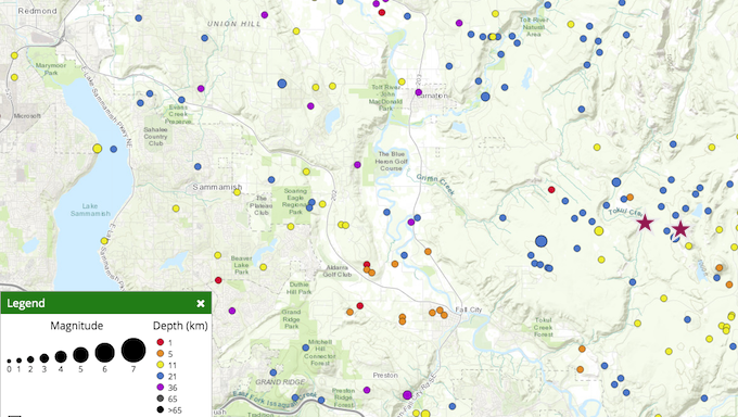
An area just east of Fall City, WA that commonly has a few small earthquakes a year again was active the night of Dec 18, 2019 (early on Dec 19 GMT time). By the morning of Dec 19 over 1,300 felt reports were logged on the Did-You_Feel-It (DYFI) web page/forms for the Mag=3.4 earthquake that took place at 7:10 PM PST. About a dozen aftershocks have been recorded since then, some too small to easily locate. The largest aftershock (Mag = 3.0), at 04:41 AM PST this morning has been reported felt by just over 300 people.
This area, on the west flank of the Cascade mountains is known for having sequences of earthquakes such as these. The faulting mechanisms associated with these event are consistent with the known north-south compression that crustal rocks in the greater Puget Sound area are under. Here is a map of the larger (Mag >2) earthquakes in this area recorded by the PNSN since it started operating in 1970. The stars (not to scale) are the locations of the recent two larger events.

Earthquakes in this area are often in the depth rang of 15 - 20 km (9 - 12 miles), which means that the shaking even right near the epicenter will not be as strong as if it were much shallower. All of these recent events have depths around 16 km. At these depths and with several mapped faults in this area it is not possible to definitively say which fault these events are on.
While these events do not lead us to think that anything unusual is going on, they are reminders that we live in earthquake country and that damaging earthquake can take place at any time.
Material will be added to the post later if additional analysis turns up anything new or interesting.