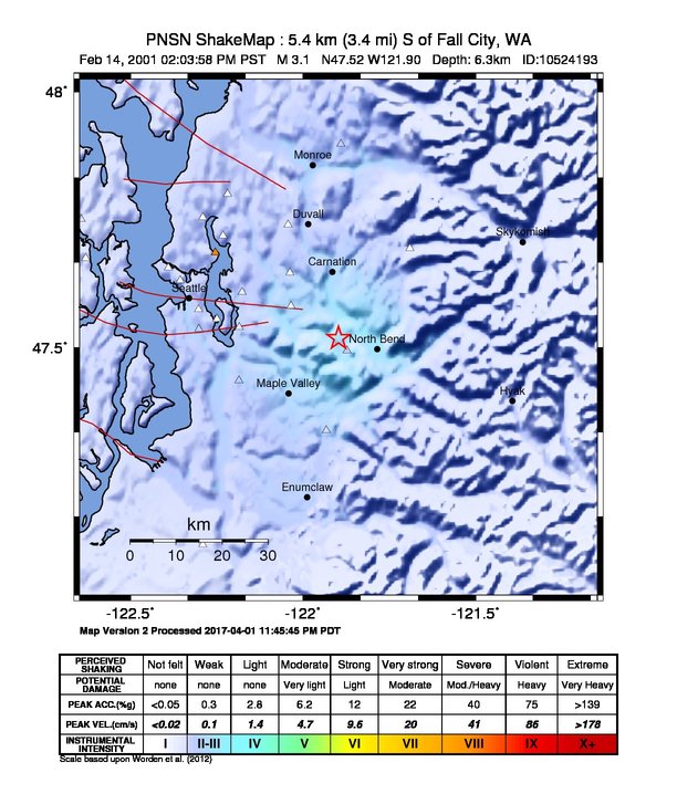
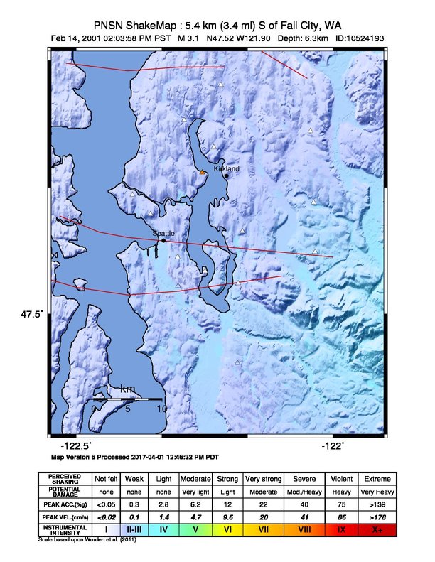
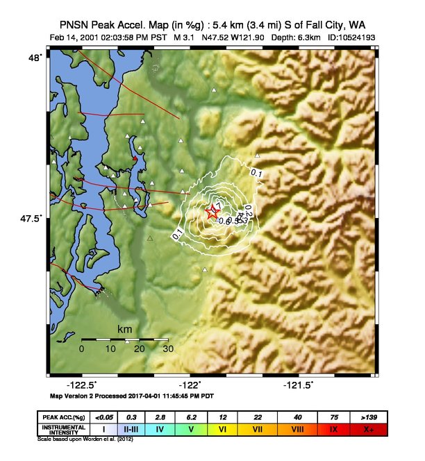
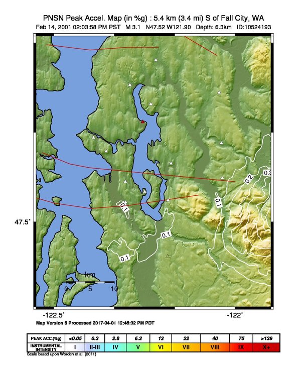
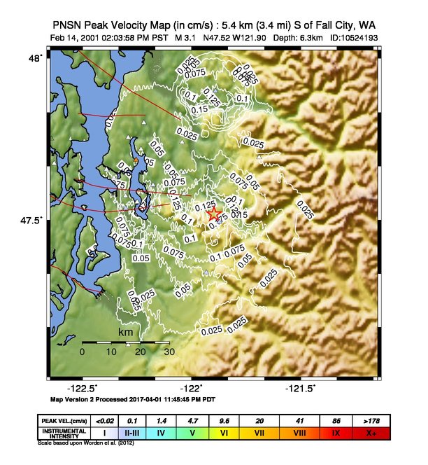
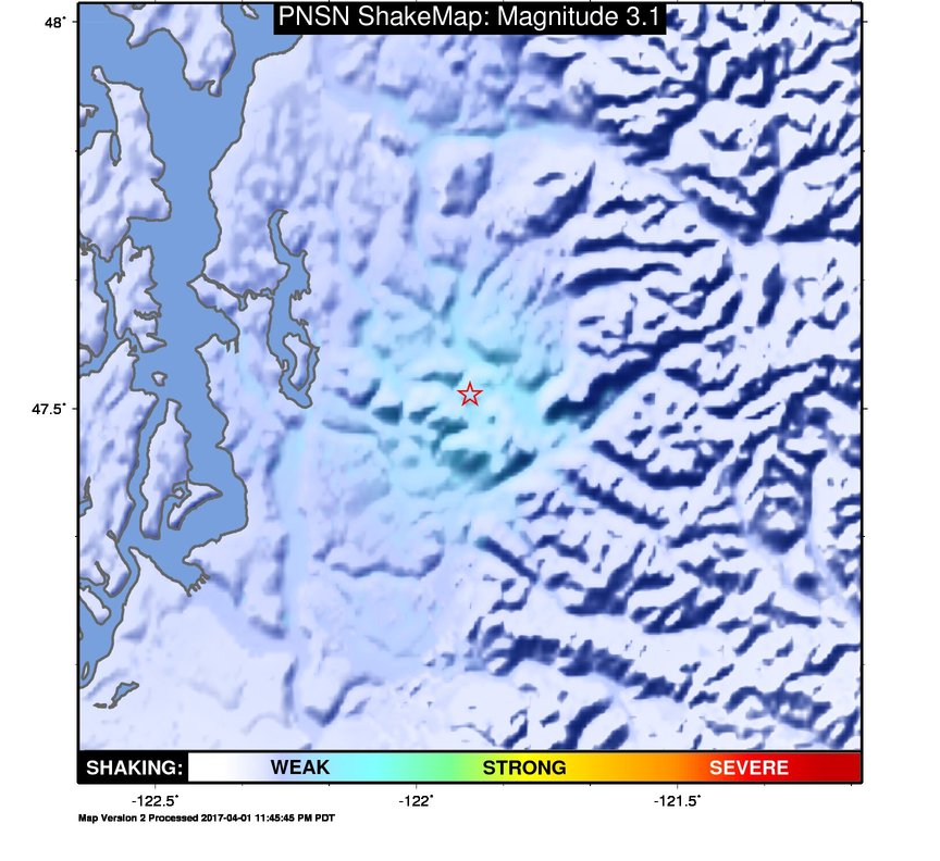
ShakeMap
Time:
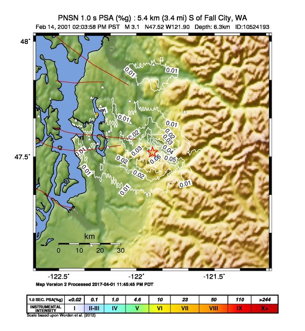
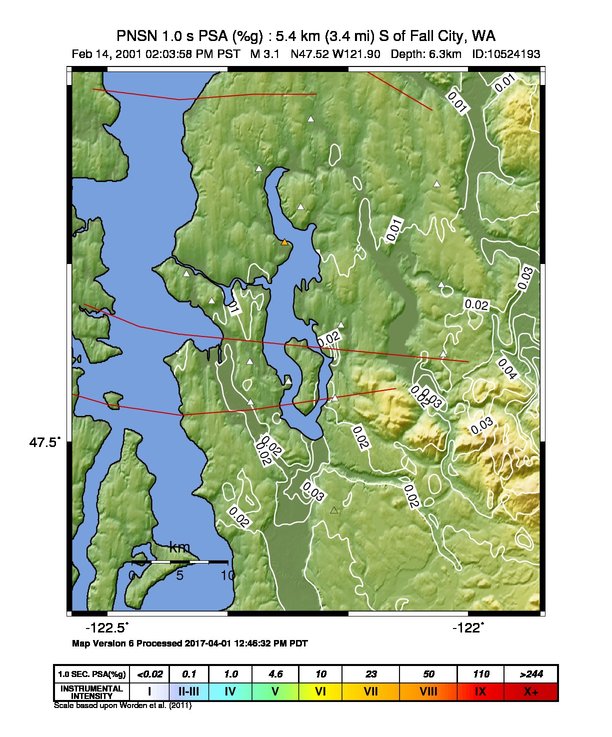
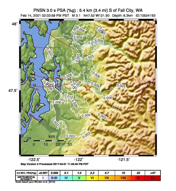
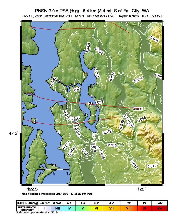
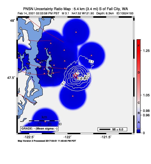
Wed February 14, 2001 22:03:58 (UTC)
|
Depth:
6.29 km
|
Event ID:
10524193
|
Location:
47.518, -121.897


Downloads
| Regional | High Resolution Seattle | |
|---|---|---|
| intensity | JPG | PS.ZIP | JPG | PS.ZIP |
| acceleration | JPG | PS.ZIP | JPG | PS.ZIP |
| velocity | JPG | PS.ZIP | JPG | PS.ZIP |
| spectral 0.3 | JPG | PS.ZIP | JPG | PS.ZIP |
| spectral 1.0 | JPG | PS.ZIP | JPG | PS.ZIP |
| spectral 3.0 | JPG | PS.ZIP | JPG | PS.ZIP |
| uncertainty | JPG | PS.ZIP | JPG | PS.ZIP |
| tv map | JPG | PS.ZIP | JPG | PS.ZIP |
| tv map bare | JPG | PS.ZIP | JPG | PS.ZIP |
| tv info sheet | TXT | TXT |
| grid | XYZ.ZIP | XML.ZIP | XYZ.ZIP | XML.ZIP |
| gis | ZIP | ZIP |
| station | TXT | XML | TXT | XML |
| metadata | TXT | TXT |
Earthquake
| Event ID | Magnitude | Date | Time | Lat | Lon | Depth |
| 10524193 | 3.1 | // | :: | N47.51820 | W121.89730 | 6.29 km |
| Magnitude Bias: | MMI | PGA | PGV | PSA 0.3 | PSA 1.0 | PSA 3.0 |
| -0.34 | -0.34 | 0.32 | -0.04 | 0.24 | 0.77 |
Seismic Stations
| UW.ALCT: | Alcott School, Redmond ANSS-SMO | Agency: Pacific Northwest Regional Seismic Network | |||
| Lat: 47.64690 Lon: -122.03770 Distance: 18.85 km from source | |||||
| Intensity: 2.1 | |||||
| Station Comp | Max Vel (cm/s) | Max Acc (%g) | PSA: 0.3 sec (%g) | 1.0 sec (%g) | 3.0 sec (%g) |
| --.ENN | 0.0485 | 0.0598 | 0.0979 | 0.0173 | 0.0044 |
| --.ENE | 0.0375 | 0.0581 | 0.0757 | 0.0144 | 0.0032 |
| --.ENZ | 0.0441 | 0.0436 | 0.0619 | 0.0209 | 0.0037 |
| UW.BRKS: | Brookside ANSS-SMO | Agency: Pacific Northwest Regional Seismic Network | |||
| Lat: 47.75520 Lon: -122.29013 Distance: 40.00 km from source | |||||
| Intensity: 1.9 | |||||
| Station Comp | Max Vel (cm/s) | Max Acc (%g) | PSA: 0.3 sec (%g) | 1.0 sec (%g) | 3.0 sec (%g) |
| --.ENN | 0.0098 | 0.0362 | 0.0446 | 0.0090 | 0.0007 |
| --.ENE | 0.0396 | 0.0332 | 0.0679 | 0.0087 | 0.0035 |
| --.ENZ | 0.0415 | 0.1521 | 0.0526 | 0.0042 | 0.0036 |
| UW.CSEN: | Crystal Springs ANSS-SMO | Agency: Pacific Northwest Regional Seismic Network | |||
| Lat: 47.80124 Lon: -122.21848 Distance: 40.11 km from source | |||||
| Intensity: 2.1 | |||||
| Station Comp | Max Vel (cm/s) | Max Acc (%g) | PSA: 0.3 sec (%g) | 1.0 sec (%g) | 3.0 sec (%g) |
| --.ENN | 0.0494 | 0.0202 | 0.0210 | 0.0061 | 0.0045 |
| --.ENE | 0.0124 | 0.0170 | 0.0343 | 0.0049 | 0.0010 |
| --.ENZ | 0.1783 | 0.0644 | 0.0186 | 0.0177 | 0.0161 |
| UW.EARN: | East Ridge ES ANSS-SMO | Agency: Pacific Northwest Regional Seismic Network | |||
| Lat: 47.74090 Lon: -122.04380 Distance: 27.81 km from source | |||||
| Intensity: 1.6 | |||||
| Station Comp | Max Vel (cm/s) | Max Acc (%g) | PSA: 0.3 sec (%g) | 1.0 sec (%g) | 3.0 sec (%g) |
| --.ENN | 0.0291 | 0.0337 | 0.0744 | 0.0056 | 0.0026 |
| --.ENE | 0.0153 | 0.0417 | 0.0666 | 0.0045 | 0.0012 |
| --.ENZ | 0.0989 | 0.1028 | 0.0399 | 0.0099 | 0.0089 |
| UW.ELW: | EchoLakeBPA | Agency: Pacific Northwest Regional Seismic Network | |||
| Lat: 47.49410 Lon: -121.87267 Distance: 7.08 km from source | |||||
| Intensity: 2.9 | |||||
| Station Comp | Max Vel (cm/s) | Max Acc (%g) | PSA: 0.3 sec (%g) | 1.0 sec (%g) | 3.0 sec (%g) |
| --.ENN | 0.1444 | 0.7782 | 0.7265 | 0.0675 | 0.0066 |
| --.ENE | 0.1079 | 0.8835 | 0.3092 | 0.0253 | 0.0022 |
| --.ENZ | 0.0669 | 0.2255 | 0.4827 | 0.0148 | 0.0028 |
| UW.FINN: | Finn Hill Jr High ANSS-SMO | Agency: Pacific Northwest Regional Seismic Network | |||
| Lat: 47.71950 Lon: -122.23220 Distance: 34.22 km from source | |||||
| Intensity: 1.5 | |||||
| Station Comp | Max Vel (cm/s) | Max Acc (%g) | PSA: 0.3 sec (%g) | 1.0 sec (%g) | 3.0 sec (%g) |
| --.ENN | 0.0262 | 0.0214 | 0.0636 | 0.0053 | 0.0022 |
| --.ENE | 0.0119 | 0.0227 | 0.0410 | 0.0071 | 0.0010 |
| --.ENZ | 0.0688 | 0.0130 | 0.0234 | 0.0064 | 0.0060 |
| UW.KIMB: | Kimball School ANSS-SMO | Agency: Pacific Northwest Regional Seismic Network | |||
| Lat: 47.57480 Lon: -122.30280 Distance: 31.71 km from source | |||||
| Intensity: 1.8 | |||||
| Station Comp | Max Vel (cm/s) | Max Acc (%g) | PSA: 0.3 sec (%g) | 1.0 sec (%g) | 3.0 sec (%g) |
| --.ENN | 0.0275 | 0.0135 | 0.0301 | 0.0069 | 0.0025 |
| --.ENE | 0.0347 | 0.0164 | 0.0295 | 0.0130 | 0.0032 |
| --.ENZ | 0.0606 | 0.0199 | 0.0146 | 0.0059 | 0.0052 |
| UW.KINR: | Kitsap Road Shed ANSS-SMO | Agency: Pacific Northwest Regional Seismic Network | |||
| Lat: 47.75167 Lon: -122.64306 Distance: 61.94 km from source | |||||
| Intensity: NaN | |||||
| Station Comp | Max Vel (cm/s) | Max Acc (%g) | PSA: 0.3 sec (%g) | 1.0 sec (%g) | 3.0 sec (%g) |
| --.ENN | 0.0100 -G | 0.0095 -G | 0.0115 -G | 0.0027 -G | 0.0010 -G |
| --.ENE | 0.0245 -G | 0.0088 -G | 0.0132 -G | 0.0031 -G | 0.0024 -G |
| --.ENZ | 0.0289 | 0.0242 | 0.0073 | 0.0023 | 0.0024 |
| UW.KITP: | Kitsap Treatment Plant ANSS-SMO | Agency: Pacific Northwest Regional Seismic Network | |||
| Lat: 47.67520 Lon: -122.62974 Distance: 57.97 km from source | |||||
| Intensity: 1.1 | |||||
| Station Comp | Max Vel (cm/s) | Max Acc (%g) | PSA: 0.3 sec (%g) | 1.0 sec (%g) | 3.0 sec (%g) |
| --.ENN | 0.0139 | 0.0153 | 0.0080 | 0.0033 | 0.0013 |
| --.ENE | 0.0166 | 0.0288 | 0.0070 | 0.0033 | 0.0013 |
| --.ENZ | 0.0160 | 0.0334 | 0.0094 | 0.0019 | 0.0017 |
| UW.LAWT: | Lawton School ANSS-SMO | Agency: Pacific Northwest Regional Seismic Network | |||
| Lat: 47.65694 Lon: -122.39062 Distance: 40.58 km from source | |||||
| Intensity: 2.1 | |||||
| Station Comp | Max Vel (cm/s) | Max Acc (%g) | PSA: 0.3 sec (%g) | 1.0 sec (%g) | 3.0 sec (%g) |
| --.ENN | 0.0183 | 0.0124 | 0.0374 | 0.0052 | 0.0016 |
| --.ENE | 0.0510 | 0.0156 | 0.0473 | 0.0072 | 0.0044 |
| --.ENZ | 0.0726 | 0.0281 | 0.0161 | 0.0072 | 0.0064 |
| UW.MBPA: | Monroe BPA, WA, USA | Agency: Pacific Northwest Regional Seismic Network | |||
| Lat: 47.89835 Lon: -121.89018 Distance: 42.74 km from source | |||||
| Intensity: 2.8 | |||||
| Station Comp | Max Vel (cm/s) | Max Acc (%g) | PSA: 0.3 sec (%g) | 1.0 sec (%g) | 3.0 sec (%g) |
| --.ENN | 0.0786 | 0.0418 | 0.0285 | 0.0087 | 0.0072 |
| --.ENE | 0.1348 | 0.0621 | 0.0289 | 0.0129 | 0.0116 |
| --.ENZ | 0.1344 | 0.0426 | 0.0126 | 0.0123 | 0.0123 |
| UW.MPL: | Maple Valley SMO | Agency: Pacific Northwest Regional Seismic Network | |||
| Lat: 47.68630 Lon: -122.25444 Distance: 33.26 km from source | |||||
| Intensity: NaN | |||||
| Station Comp | Max Vel (cm/s) | Max Acc (%g) | PSA: 0.3 sec (%g) | 1.0 sec (%g) | 3.0 sec (%g) |
| --.ENN | 0.0155 -G | 0.0086 -G | 0.0347 -G | 0.0023 -G | 0.0014 -G |
| --.ENE | 0.0052 | 0.0126 | 0.0321 | 0.0033 | 0.0005 |
| --.ENZ | 0.0057 | 0.0102 | 0.0112 | 0.0018 | 0.0006 |
| UW.NOWS: | NOAA, Seattle Bldg 3-SMO-IDS20 | Agency: Pacific Northwest Regional Seismic Network | |||
| Lat: 47.68630 Lon: -122.25444 Distance: 33.26 km from source | |||||
| Intensity: 8.5 - T | |||||
| Station Comp | Max Vel (cm/s) | Max Acc (%g) | PSA: 0.3 sec (%g) | 1.0 sec (%g) | 3.0 sec (%g) |
| --.ENN | 0.0424 -T | 0.0379 -T | 0.1301 -T | 0.0091 -T | 0.0036 -T |
| --.ENE | 45.7495 -T | 467.6176 -T | 89.9349 -T | 26.4300 -T | 8.4100 -T |
| --.ENZ | 0.0276 -T | 0.0155 -T | 0.0232 -T | 0.0051 -T | 0.0038 -T |
| UW.PCEP: | PC East Precinct ANSS-SMO | Agency: Pacific Northwest Regional Seismic Network | |||
| Lat: 47.11160 Lon: -122.29000 Distance: 54.41 km from source | |||||
| Intensity: 1.1 | |||||
| Station Comp | Max Vel (cm/s) | Max Acc (%g) | PSA: 0.3 sec (%g) | 1.0 sec (%g) | 3.0 sec (%g) |
| --.ENN | 0.0067 | 0.0185 | 0.0097 | 0.0032 | 0.0010 |
| --.ENE | 0.0173 | 0.0139 | 0.0205 | 0.0027 | 0.0012 |
| --.ENZ | 0.0440 | 0.0274 | 0.0080 | 0.0039 | 0.0036 |
| UW.PNLK: | Pine Lake JH ANSS-SMO | Agency: Pacific Northwest Regional Seismic Network | |||
| Lat: 47.58162 Lon: -122.03483 Distance: 13.99 km from source | |||||
| Intensity: 2.2 | |||||
| Station Comp | Max Vel (cm/s) | Max Acc (%g) | PSA: 0.3 sec (%g) | 1.0 sec (%g) | 3.0 sec (%g) |
| --.ENN | 0.0264 | 0.0523 | 0.0994 | 0.0140 | 0.0012 |
| --.ENE | 0.0523 | 0.0641 | 0.1704 | 0.0102 | 0.0046 |
| --.ENZ | 0.0278 | 0.0535 | 0.1168 | 0.0141 | 0.0023 |
| UW.QAW: | Queen Anne, Seattle SMO-IDS24 | Agency: Pacific Northwest Regional Seismic Network | |||
| Lat: 47.63157 Lon: -122.35554 Distance: 37.15 km from source | |||||
| Intensity: 2.0 | |||||
| Station Comp | Max Vel (cm/s) | Max Acc (%g) | PSA: 0.3 sec (%g) | 1.0 sec (%g) | 3.0 sec (%g) |
| --.ENN | 0.0446 | 0.0298 | 0.0496 | 0.0054 | 0.0042 |
| --.ENE | 0.0392 | 0.0207 | 0.0385 | 0.0054 | 0.0035 |
| --.ENZ | 0.0283 | 0.0164 | 0.0292 | 0.0041 | 0.0044 |
| UW.RAW: | Raver BPA SMO-IDS20 | Agency: Pacific Northwest Regional Seismic Network | |||
| Lat: 47.33705 Lon: -121.93267 Distance: 21.27 km from source | |||||
| Intensity: 2.6 | |||||
| Station Comp | Max Vel (cm/s) | Max Acc (%g) | PSA: 0.3 sec (%g) | 1.0 sec (%g) | 3.0 sec (%g) |
| --.ENN | 0.0314 | 0.0415 | 0.0943 | 0.0071 | 0.0032 |
| --.ENE | 0.0881 | 0.0297 | 0.0899 | 0.0102 | 0.0080 |
| --.ENZ | 0.0807 | 0.0634 | 0.0429 | 0.0099 | 0.0088 |
| UW.RBEN: | Benson El., ANSS-SMO | Agency: Pacific Northwest Regional Seismic Network | |||
| Lat: 47.43520 Lon: -122.18610 Distance: 24.41 km from source | |||||
| Intensity: NaN | |||||
| Station Comp | Max Vel (cm/s) | Max Acc (%g) | PSA: 0.3 sec (%g) | 1.0 sec (%g) | 3.0 sec (%g) |
| --.ENN | 0.0188 -G | 0.0074 -G | 0.0121 -G | 0.0025 -G | 0.0019 -G |
| --.ENE | 0.0255 -G | 0.0071 -G | 0.0146 -G | 0.0039 -G | 0.0022 -G |
| --.ENZ | 0.0107 | 0.0084 | 0.0103 | 0.0027 | 0.0013 |
| UW.RHAZ: | Hazelwood ES ANSS-SMO | Agency: Pacific Northwest Regional Seismic Network | |||
| Lat: 47.54020 Lon: -122.18493 Distance: 22.63 km from source | |||||
| Intensity: 2.4 | |||||
| Station Comp | Max Vel (cm/s) | Max Acc (%g) | PSA: 0.3 sec (%g) | 1.0 sec (%g) | 3.0 sec (%g) |
| --.ENN | 0.0325 | 0.0161 | 0.0202 | 0.0063 | 0.0053 |
| --.ENE | 0.0653 | 0.0157 | 0.0281 | 0.0135 | 0.0114 |
| --.ENZ | 0.0329 | 0.0137 | 0.0116 | 0.0065 | 0.0048 |
| UW.SP2: | Seward Park, Seattle SMO-IDS24 BB(7/97) | Agency: Pacific Northwest Regional Seismic Network | |||
| Lat: 47.55629 Lon: -122.24923 Distance: 27.49 km from source | |||||
| Intensity: 1.4 | |||||
| Station Comp | Max Vel (cm/s) | Max Acc (%g) | PSA: 0.3 sec (%g) | 1.0 sec (%g) | 3.0 sec (%g) |
| --.ENN | 0.0146 | 0.0236 | 0.0565 | 0.0078 | 0.0006 |
| --.ENE | 0.0235 | 0.0368 | 0.0920 | 0.0132 | 0.0009 |
| --.ENZ | 0.0145 | 0.0254 | 0.0669 | 0.0058 | 0.0005 |
| UW.TKCO: | King Co EOC - SMO | Agency: Pacific Northwest Regional Seismic Network | |||
| Lat: 47.53668 Lon: -122.30165 Distance: 31.07 km from source | |||||
| Intensity: 3.0 | |||||
| Station Comp | Max Vel (cm/s) | Max Acc (%g) | PSA: 0.3 sec (%g) | 1.0 sec (%g) | 3.0 sec (%g) |
| --.ENN | 0.1730 | 0.1486 | 0.0517 | 0.0172 | 0.0149 |
| --.ENE | 0.1106 | 0.1069 | 0.0587 | 0.0108 | 0.0095 |
| --.ENZ | 0.1288 | 0.5627 | 0.0840 | 0.0127 | 0.0112 |
| UW.TTW: | Tolt Res, WA CREST BB SMO | Agency: Pacific Northwest Regional Seismic Network | |||
| Lat: 47.69445 Lon: -121.69011 Distance: 25.79 km from source | |||||
| Intensity: 1.8 | |||||
| Station Comp | Max Vel (cm/s) | Max Acc (%g) | PSA: 0.3 sec (%g) | 1.0 sec (%g) | 3.0 sec (%g) |
| --.BHE | 0.0251 | 0.0660 | 0.1270 | 0.0053 | 0.0005 |
| --.BHN | 0.0351 | 0.0989 | 0.1186 | 0.0067 | 0.0006 |
| --.BHZ | 0.0247 | 0.0950 | 0.0811 | 0.0033 | 0.0004 |
| UW.WISC: | Wilburton Center ANSS-SMO | Agency: Pacific Northwest Regional Seismic Network | |||
| Lat: 47.60878 Lon: -122.17632 Distance: 24.07 km from source | |||||
| Intensity: 2.2 | |||||
| Station Comp | Max Vel (cm/s) | Max Acc (%g) | PSA: 0.3 sec (%g) | 1.0 sec (%g) | 3.0 sec (%g) |
| --.ENN | 0.0113 | 0.0305 | 0.0574 | 0.0091 | 0.0009 |
| --.ENE | 0.0564 | 0.0240 | 0.0436 | 0.0080 | 0.0052 |
| --.ENZ | 0.0835 | 0.0194 | 0.0189 | 0.0081 | 0.0076 |
Earthquake
| Event ID | Magnitude | Date | Time | Lat | Lon | Depth |
| 10524193 | 3.1 | // | :: | N47.51820 | W121.89730 | 6.29 km |
| Magnitude Bias: | MMI | PGA | PGV | PSA 0.3 | PSA 1.0 | PSA 3.0 |
| -0.19 | -0.33 | 0.44 | -0.00 | 0.32 | 0.79 |
Seismic Stations
| UW.ALCT: | Alcott School, Redmond ANSS-SMO | Agency: Pacific Northwest Regional Seismic Network | |||
| Lat: 47.64690 Lon: -122.03770 Distance: 18.85 km from epicenter | |||||
| Intensity: 2.1 | |||||
| Station Comp | Max Vel (cm/s) | Max Acc (%g) | PSA: 0.3 sec (%g) | 1.0 sec (%g) | 3.0 sec (%g) |
| --.ENN | 0.0485 | 0.0598 | 0.0979 | 0.0173 | 0.0044 |
| --.ENE | 0.0375 | 0.0581 | 0.0757 | 0.0144 | 0.0032 |
| --.ENZ | 0.0441 | 0.0436 | 0.0619 | 0.0209 | 0.0037 |
| UW.BRKS: | Brookside ANSS-SMO | Agency: Pacific Northwest Regional Seismic Network | |||
| Lat: 47.75520 Lon: -122.29013 Distance: 40.00 km from epicenter | |||||
| Intensity: 1.9 | |||||
| Station Comp | Max Vel (cm/s) | Max Acc (%g) | PSA: 0.3 sec (%g) | 1.0 sec (%g) | 3.0 sec (%g) |
| --.ENN | 0.0098 | 0.0362 | 0.0446 | 0.0090 | 0.0007 |
| --.ENE | 0.0396 | 0.0332 | 0.0679 | 0.0087 | 0.0035 |
| --.ENZ | 0.0415 | 0.1521 | 0.0526 | 0.0042 | 0.0036 |
| UW.CSEN: | Crystal Springs ANSS-SMO | Agency: Pacific Northwest Regional Seismic Network | |||
| Lat: 47.80124 Lon: -122.21848 Distance: 40.11 km from epicenter | |||||
| Intensity: 2.1 | |||||
| Station Comp | Max Vel (cm/s) | Max Acc (%g) | PSA: 0.3 sec (%g) | 1.0 sec (%g) | 3.0 sec (%g) |
| --.ENN | 0.0494 | 0.0202 | 0.0210 | 0.0061 | 0.0045 |
| --.ENE | 0.0124 | 0.0170 | 0.0343 | 0.0049 | 0.0010 |
| --.ENZ | 0.1783 | 0.0644 | 0.0186 | 0.0177 | 0.0161 |
| UW.EARN: | East Ridge ES ANSS-SMO | Agency: Pacific Northwest Regional Seismic Network | |||
| Lat: 47.74090 Lon: -122.04380 Distance: 27.81 km from epicenter | |||||
| Intensity: 1.6 | |||||
| Station Comp | Max Vel (cm/s) | Max Acc (%g) | PSA: 0.3 sec (%g) | 1.0 sec (%g) | 3.0 sec (%g) |
| --.ENN | 0.0291 | 0.0337 | 0.0744 | 0.0056 | 0.0026 |
| --.ENE | 0.0153 | 0.0417 | 0.0666 | 0.0045 | 0.0012 |
| --.ENZ | 0.0989 | 0.1028 | 0.0399 | 0.0099 | 0.0089 |
| UW.FINN: | Finn Hill Jr High ANSS-SMO | Agency: Pacific Northwest Regional Seismic Network | |||
| Lat: 47.71950 Lon: -122.23220 Distance: 34.22 km from epicenter | |||||
| Intensity: 1.5 | |||||
| Station Comp | Max Vel (cm/s) | Max Acc (%g) | PSA: 0.3 sec (%g) | 1.0 sec (%g) | 3.0 sec (%g) |
| --.ENN | 0.0262 | 0.0214 | 0.0636 | 0.0053 | 0.0022 |
| --.ENE | 0.0119 | 0.0227 | 0.0410 | 0.0071 | 0.0010 |
| --.ENZ | 0.0688 | 0.0130 | 0.0234 | 0.0064 | 0.0060 |
| UW.KIMB: | Kimball School ANSS-SMO | Agency: Pacific Northwest Regional Seismic Network | |||
| Lat: 47.57480 Lon: -122.30280 Distance: 31.71 km from epicenter | |||||
| Intensity: 1.8 | |||||
| Station Comp | Max Vel (cm/s) | Max Acc (%g) | PSA: 0.3 sec (%g) | 1.0 sec (%g) | 3.0 sec (%g) |
| --.ENN | 0.0275 | 0.0135 | 0.0301 | 0.0069 | 0.0025 |
| --.ENE | 0.0347 | 0.0164 | 0.0295 | 0.0130 | 0.0032 |
| --.ENZ | 0.0606 | 0.0199 | 0.0146 | 0.0059 | 0.0052 |
| UW.LAWT: | Lawton School ANSS-SMO | Agency: Pacific Northwest Regional Seismic Network | |||
| Lat: 47.65694 Lon: -122.39062 Distance: 40.58 km from epicenter | |||||
| Intensity: 2.1 | |||||
| Station Comp | Max Vel (cm/s) | Max Acc (%g) | PSA: 0.3 sec (%g) | 1.0 sec (%g) | 3.0 sec (%g) |
| --.ENN | 0.0183 | 0.0124 | 0.0374 | 0.0052 | 0.0016 |
| --.ENE | 0.0510 | 0.0156 | 0.0473 | 0.0072 | 0.0044 |
| --.ENZ | 0.0726 | 0.0281 | 0.0161 | 0.0072 | 0.0064 |
| UW.MPL: | Maple Valley SMO | Agency: Pacific Northwest Regional Seismic Network | |||
| Lat: 47.68630 Lon: -122.25444 Distance: 33.26 km from epicenter | |||||
| Intensity: NaN | |||||
| Station Comp | Max Vel (cm/s) | Max Acc (%g) | PSA: 0.3 sec (%g) | 1.0 sec (%g) | 3.0 sec (%g) |
| --.ENN | 0.0155 -G | 0.0086 -G | 0.0347 -G | 0.0023 -G | 0.0014 -G |
| --.ENE | 0.0052 | 0.0126 | 0.0321 | 0.0033 | 0.0005 |
| --.ENZ | 0.0057 | 0.0102 | 0.0112 | 0.0018 | 0.0006 |
| UW.NOWS: | NOAA, Seattle Bldg 3-SMO-IDS20 | Agency: Pacific Northwest Regional Seismic Network | |||
| Lat: 47.68630 Lon: -122.25444 Distance: 33.26 km from epicenter | |||||
| Intensity: 8.5 - T | |||||
| Station Comp | Max Vel (cm/s) | Max Acc (%g) | PSA: 0.3 sec (%g) | 1.0 sec (%g) | 3.0 sec (%g) |
| --.ENN | 0.0424 -T | 0.0379 -T | 0.1301 -T | 0.0091 -T | 0.0036 -T |
| --.ENE | 45.7495 -T | 467.6176 -T | 89.9349 -T | 26.4300 -T | 8.4100 -T |
| --.ENZ | 0.0276 -T | 0.0155 -T | 0.0232 -T | 0.0051 -T | 0.0038 -T |
| UW.PNLK: | Pine Lake JH ANSS-SMO | Agency: Pacific Northwest Regional Seismic Network | |||
| Lat: 47.58162 Lon: -122.03483 Distance: 13.99 km from epicenter | |||||
| Intensity: 2.2 | |||||
| Station Comp | Max Vel (cm/s) | Max Acc (%g) | PSA: 0.3 sec (%g) | 1.0 sec (%g) | 3.0 sec (%g) |
| --.ENN | 0.0264 | 0.0523 | 0.0994 | 0.0140 | 0.0012 |
| --.ENE | 0.0523 | 0.0641 | 0.1704 | 0.0102 | 0.0046 |
| --.ENZ | 0.0278 | 0.0535 | 0.1168 | 0.0141 | 0.0023 |
| UW.QAW: | Queen Anne, Seattle SMO-IDS24 | Agency: Pacific Northwest Regional Seismic Network | |||
| Lat: 47.63157 Lon: -122.35554 Distance: 37.15 km from epicenter | |||||
| Intensity: 2.0 | |||||
| Station Comp | Max Vel (cm/s) | Max Acc (%g) | PSA: 0.3 sec (%g) | 1.0 sec (%g) | 3.0 sec (%g) |
| --.ENN | 0.0446 | 0.0298 | 0.0496 | 0.0054 | 0.0042 |
| --.ENE | 0.0392 | 0.0207 | 0.0385 | 0.0054 | 0.0035 |
| --.ENZ | 0.0283 | 0.0164 | 0.0292 | 0.0041 | 0.0044 |
| UW.RBEN: | Benson El., ANSS-SMO | Agency: Pacific Northwest Regional Seismic Network | |||
| Lat: 47.43520 Lon: -122.18610 Distance: 24.41 km from epicenter | |||||
| Intensity: NaN | |||||
| Station Comp | Max Vel (cm/s) | Max Acc (%g) | PSA: 0.3 sec (%g) | 1.0 sec (%g) | 3.0 sec (%g) |
| --.ENN | 0.0188 -G | 0.0074 -G | 0.0121 -G | 0.0025 -G | 0.0019 -G |
| --.ENE | 0.0255 -G | 0.0071 -G | 0.0146 -G | 0.0039 -G | 0.0022 -G |
| --.ENZ | 0.0107 | 0.0084 | 0.0103 | 0.0027 | 0.0013 |
| UW.RHAZ: | Hazelwood ES ANSS-SMO | Agency: Pacific Northwest Regional Seismic Network | |||
| Lat: 47.54020 Lon: -122.18493 Distance: 22.63 km from epicenter | |||||
| Intensity: 2.4 | |||||
| Station Comp | Max Vel (cm/s) | Max Acc (%g) | PSA: 0.3 sec (%g) | 1.0 sec (%g) | 3.0 sec (%g) |
| --.ENN | 0.0325 | 0.0161 | 0.0202 | 0.0063 | 0.0053 |
| --.ENE | 0.0653 | 0.0157 | 0.0281 | 0.0135 | 0.0114 |
| --.ENZ | 0.0329 | 0.0137 | 0.0116 | 0.0065 | 0.0048 |
| UW.SP2: | Seward Park, Seattle SMO-IDS24 BB(7/97) | Agency: Pacific Northwest Regional Seismic Network | |||
| Lat: 47.55629 Lon: -122.24923 Distance: 27.49 km from epicenter | |||||
| Intensity: 1.4 | |||||
| Station Comp | Max Vel (cm/s) | Max Acc (%g) | PSA: 0.3 sec (%g) | 1.0 sec (%g) | 3.0 sec (%g) |
| --.ENN | 0.0146 | 0.0236 | 0.0565 | 0.0078 | 0.0006 |
| --.ENE | 0.0235 | 0.0368 | 0.0920 | 0.0132 | 0.0009 |
| --.ENZ | 0.0145 | 0.0254 | 0.0669 | 0.0058 | 0.0005 |
| UW.TKCO: | King Co EOC - SMO | Agency: Pacific Northwest Regional Seismic Network | |||
| Lat: 47.53668 Lon: -122.30165 Distance: 31.07 km from epicenter | |||||
| Intensity: 3.0 | |||||
| Station Comp | Max Vel (cm/s) | Max Acc (%g) | PSA: 0.3 sec (%g) | 1.0 sec (%g) | 3.0 sec (%g) |
| --.ENN | 0.1730 | 0.1486 | 0.0517 | 0.0172 | 0.0149 |
| --.ENE | 0.1106 | 0.1069 | 0.0587 | 0.0108 | 0.0095 |
| --.ENZ | 0.1288 | 0.5627 | 0.0840 | 0.0127 | 0.0112 |
| UW.WISC: | Wilburton Center ANSS-SMO | Agency: Pacific Northwest Regional Seismic Network | |||
| Lat: 47.60878 Lon: -122.17632 Distance: 24.07 km from epicenter | |||||
| Intensity: 2.2 | |||||
| Station Comp | Max Vel (cm/s) | Max Acc (%g) | PSA: 0.3 sec (%g) | 1.0 sec (%g) | 3.0 sec (%g) |
| --.ENN | 0.0113 | 0.0305 | 0.0574 | 0.0091 | 0.0009 |
| --.ENE | 0.0564 | 0.0240 | 0.0436 | 0.0080 | 0.0052 |
| --.ENZ | 0.0835 | 0.0194 | 0.0189 | 0.0081 | 0.0076 |