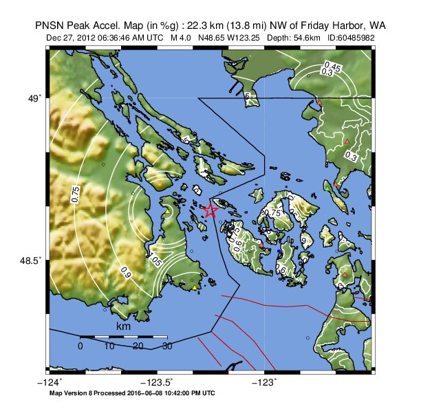
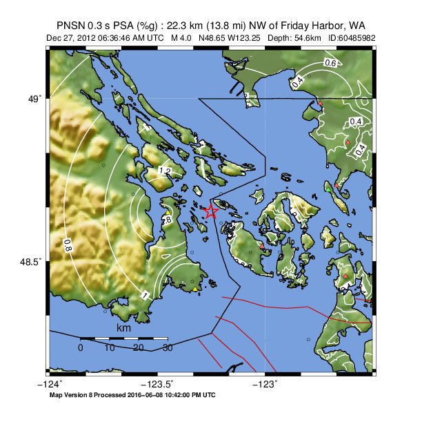
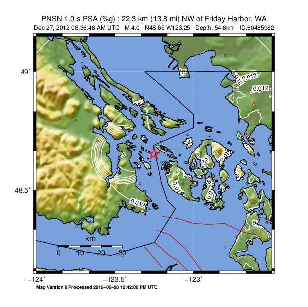
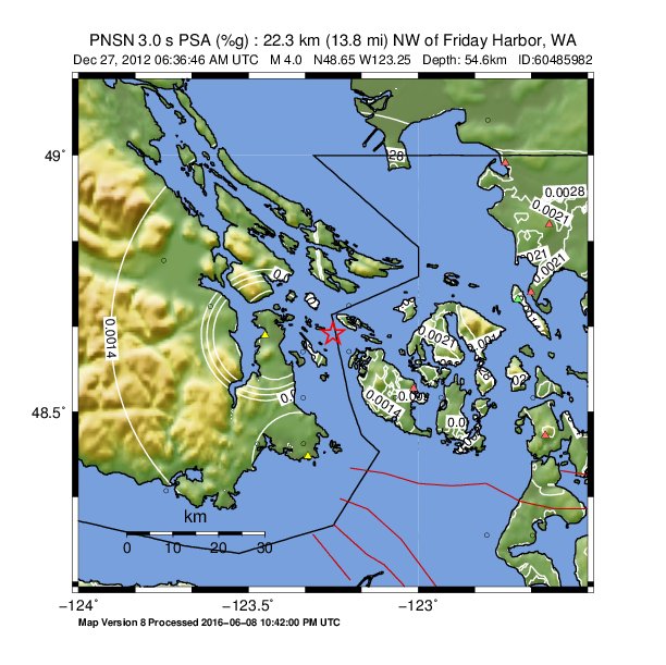
ShakeMap
Time:
Thu December 27, 2012 06:36:46 (UTC)
|
Depth:
54.49 km
|
Event ID:
60485982
|
Location:
48.653, -123.251
Pseudo Acceleration Spectra
Downloads
| Regional | |
|---|---|
| intensity | JPG | PS.ZIP |
| acceleration | JPG | PS.ZIP |
| velocity | JPG | PS.ZIP |
| spectral 0.3 | JPG | PS.ZIP |
| spectral 1.0 | JPG | PS.ZIP |
| spectral 3.0 | JPG | PS.ZIP |
| uncertainty | JPG | PS.ZIP |
| tv map | JPG | PS.ZIP |
| tv map bare | JPG | PS.ZIP |
| tv info sheet | TXT |
| grid | XYZ.ZIP | XML.ZIP |
| gis | ZIP |
| station | TXT | XML |
| metadata | TXT |
Earthquake
| Event ID | Magnitude | Date | Time | Lat | Lon | Depth |
| 60485982 | 4.0 | // | :: | N48.65270 | W123.25070 | 54.65 km |
| Magnitude Bias: | MMI | PGA | PGV | PSA 0.3 | PSA 1.0 | PSA 3.0 |
| -0.31 | -1.41 | -0.72 | -1.68 | -1.51 | -0.73 |
Seismic Stations
| 1: | UTM:(10U 044 535 10000) | Agency: USGS (Did You Feel It?) | |||
| Lat: 48.34570 Lon: -123.74220 Distance: 73.91 km from source | |||||
| Intensity: 2.8 | |||||
| Station Comp | Max Vel (cm/s) | Max Acc (%g) | PSA: 0.3 sec (%g) | 1.0 sec (%g) | 3.0 sec (%g) |
| DERIVED | -- | -- | -- | -- | -- |
| 10: | UTM:(10U 048 539 10000) | Agency: USGS (Did You Feel It?) | |||
| Lat: 48.70780 Lon: -123.20380 Distance: 55.10 km from source | |||||
| Intensity: 2.2 | |||||
| Station Comp | Max Vel (cm/s) | Max Acc (%g) | PSA: 0.3 sec (%g) | 1.0 sec (%g) | 3.0 sec (%g) |
| DERIVED | -- | -- | -- | -- | -- |
| 14: | UTM:(10U 049 537 10000) | Agency: USGS (Did You Feel It?) | |||
| Lat: 48.52800 Lon: -123.06770 Distance: 57.97 km from source | |||||
| Intensity: 2.2 | |||||
| Station Comp | Max Vel (cm/s) | Max Acc (%g) | PSA: 0.3 sec (%g) | 1.0 sec (%g) | 3.0 sec (%g) |
| DERIVED | -- | -- | -- | -- | -- |
| 18: | UTM:(10U 050 537 10000) | Agency: USGS (Did You Feel It?) | |||
| Lat: 48.52810 Lon: -122.93220 Distance: 61.05 km from source | |||||
| Intensity: 3.1 | |||||
| Station Comp | Max Vel (cm/s) | Max Acc (%g) | PSA: 0.3 sec (%g) | 1.0 sec (%g) | 3.0 sec (%g) |
| DERIVED | -- | 0.49 | -- | -- | -- |
| 2: | UTM:(10U 044 540 10000) | Agency: USGS (Did You Feel It?) | |||
| Lat: 48.79560 Lon: -123.74880 Distance: 67.63 km from source | |||||
| Intensity: 2.4 | |||||
| Station Comp | Max Vel (cm/s) | Max Acc (%g) | PSA: 0.3 sec (%g) | 1.0 sec (%g) | 3.0 sec (%g) |
| DERIVED | -- | -- | -- | -- | -- |
| 20: | UTM:(10U 051 534 10000) | Agency: USGS (Did You Feel It?) | |||
| Lat: 48.25800 Lon: -122.79780 Distance: 77.64 km from source | |||||
| Intensity: 2.8 | |||||
| Station Comp | Max Vel (cm/s) | Max Acc (%g) | PSA: 0.3 sec (%g) | 1.0 sec (%g) | 3.0 sec (%g) |
| DERIVED | -- | -- | -- | -- | -- |
| 21: | UTM:(10U 051 543 10000) | Agency: USGS (Did You Feel It?) | |||
| Lat: 49.06770 Lon: -122.79460 Distance: 78.93 km from source | |||||
| Intensity: 2.0 | |||||
| Station Comp | Max Vel (cm/s) | Max Acc (%g) | PSA: 0.3 sec (%g) | 1.0 sec (%g) | 3.0 sec (%g) |
| DERIVED | -- | -- | -- | -- | -- |
| 22: | UTM:(10U 052 534 10000) | Agency: USGS (Did You Feel It?) | |||
| Lat: 48.25770 Lon: -122.66320 Distance: 82.42 km from source | |||||
| Intensity: 2.0 | |||||
| Station Comp | Max Vel (cm/s) | Max Acc (%g) | PSA: 0.3 sec (%g) | 1.0 sec (%g) | 3.0 sec (%g) |
| DERIVED | -- | -- | -- | -- | -- |
| 23: | UTM:(10U 052 537 10000) | Agency: USGS (Did You Feel It?) | |||
| Lat: 48.52760 Lon: -122.66130 Distance: 71.13 km from source | |||||
| Intensity: 2.6 | |||||
| Station Comp | Max Vel (cm/s) | Max Acc (%g) | PSA: 0.3 sec (%g) | 1.0 sec (%g) | 3.0 sec (%g) |
| DERIVED | -- | -- | -- | -- | -- |
| 3: | UTM:(10U 045 539 10000) | Agency: USGS (Did You Feel It?) | |||
| Lat: 48.70640 Lon: -123.61160 Distance: 61.03 km from source | |||||
| Intensity: 2.3 | |||||
| Station Comp | Max Vel (cm/s) | Max Acc (%g) | PSA: 0.3 sec (%g) | 1.0 sec (%g) | 3.0 sec (%g) |
| DERIVED | -- | -- | -- | -- | -- |
| 4: | UTM:(10U 046 536 10000) | Agency: USGS (Did You Feel It?) | |||
| Lat: 48.43720 Lon: -123.47320 Distance: 61.88 km from source | |||||
| Intensity: 2.7 | |||||
| Station Comp | Max Vel (cm/s) | Max Acc (%g) | PSA: 0.3 sec (%g) | 1.0 sec (%g) | 3.0 sec (%g) |
| DERIVED | -- | -- | -- | -- | -- |
| 5: | UTM:(10U 046 538 10000) | Agency: USGS (Did You Feel It?) | |||
| Lat: 48.61710 Lon: -123.47480 Distance: 57.21 km from source | |||||
| Intensity: 2.4 | |||||
| Station Comp | Max Vel (cm/s) | Max Acc (%g) | PSA: 0.3 sec (%g) | 1.0 sec (%g) | 3.0 sec (%g) |
| DERIVED | -- | -- | -- | -- | -- |
| 6: | UTM:(10U 047 536 10000) | Agency: USGS (Did You Feel It?) | |||
| Lat: 48.43760 Lon: -123.33800 Distance: 60.00 km from source | |||||
| Intensity: 2.7 | |||||
| Station Comp | Max Vel (cm/s) | Max Acc (%g) | PSA: 0.3 sec (%g) | 1.0 sec (%g) | 3.0 sec (%g) |
| DERIVED | -- | -- | -- | -- | -- |
| 7: | UTM:(10U 047 537 10000) | Agency: USGS (Did You Feel It?) | |||
| Lat: 48.52760 Lon: -123.33850 Distance: 56.76 km from source | |||||
| Intensity: 2.0 | |||||
| Station Comp | Max Vel (cm/s) | Max Acc (%g) | PSA: 0.3 sec (%g) | 1.0 sec (%g) | 3.0 sec (%g) |
| DERIVED | -- | -- | -- | -- | -- |
| 8: | UTM:(10U 047 538 10000) | Agency: USGS (Did You Feel It?) | |||
| Lat: 48.61760 Lon: -123.33920 Distance: 55.17 km from source | |||||
| Intensity: 2.0 | |||||
| Station Comp | Max Vel (cm/s) | Max Acc (%g) | PSA: 0.3 sec (%g) | 1.0 sec (%g) | 3.0 sec (%g) |
| DERIVED | -- | -- | -- | -- | -- |
| 9: | UTM:(10U 048 538 10000) | Agency: USGS (Did You Feel It?) | |||
| Lat: 48.61790 Lon: -123.20350 Distance: 54.90 km from source | |||||
| Intensity: 2.6 | |||||
| Station Comp | Max Vel (cm/s) | Max Acc (%g) | PSA: 0.3 sec (%g) | 1.0 sec (%g) | 3.0 sec (%g) |
| DERIVED | -- | -- | -- | -- | -- |
| CN.PGC: | SIDNEY, BC, CANADA | Agency: Canadian National Seismograph Network | |||
| Lat: 48.65000 Lon: -123.45080 Distance: 56.59 km from source | |||||
| Intensity: 2.8 | |||||
| Station Comp | Max Vel (cm/s) | Max Acc (%g) | PSA: 0.3 sec (%g) | 1.0 sec (%g) | 3.0 sec (%g) |
| --.BHE | 0.1610 | 0.3890 | 0.5554 | 0.0646 | 0.0052 |
| --.BHN | 0.0415 | 0.1411 | 0.1309 | 0.0142 | 0.0010 |
| CN.VGZ: | GONZALES, BC, CANADA | Agency: Canadian National Seismograph Network | |||
| Lat: 48.41390 Lon: -123.32440 Distance: 61.00 km from source | |||||
| Intensity: 2.0 | |||||
| Station Comp | Max Vel (cm/s) | Max Acc (%g) | PSA: 0.3 sec (%g) | 1.0 sec (%g) | 3.0 sec (%g) |
| --.HHE | 0.0494 | 0.1415 | 0.1616 | 0.0085 | 0.0011 |
| --.HHN | 0.0363 | 0.1441 | 0.1631 | 0.0116 | 0.0010 |
| TA.A04D: | Lummi Island, WA, USA | Agency: USArray Transportable Array | |||
| Lat: 48.72010 Lon: -122.70630 Distance: 68.12 km from source | |||||
| Intensity: 1.7 | |||||
| Station Comp | Max Vel (cm/s) | Max Acc (%g) | PSA: 0.3 sec (%g) | 1.0 sec (%g) | 3.0 sec (%g) |
| --.BHE | 0.0295 | 0.0830 | 0.1575 | 0.0068 | 0.0007 |
| --.BHN | 0.0370 | 0.1190 | 0.1010 | 0.0122 | 0.0008 |
| UW.ERW: | Mt. Erie, WA, USA | Agency: Pacific Northwest Regional Seismic Network | |||
| Lat: 48.45400 Lon: -122.62506 Distance: 74.80 km from source | |||||
| Intensity: 1.4 | |||||
| Station Comp | Max Vel (cm/s) | Max Acc (%g) | PSA: 0.3 sec (%g) | 1.0 sec (%g) | 3.0 sec (%g) |
| --.ENN | 0.0214 | 0.0768 | 0.0482 | 0.0039 | 0.0007 |
| --.ENE | 0.0286 | 0.1036 | 0.1067 | 0.0098 | 0.0008 |
| UW.QGBP: | Lena Rd. Bellingham, WA | Agency: Pacific Northwest Regional Seismic Network | |||
| Lat: 48.73338 Lon: -122.66756 Distance: 69.99 km from source | |||||
| Intensity: 1.6 | |||||
| Station Comp | Max Vel (cm/s) | Max Acc (%g) | PSA: 0.3 sec (%g) | 1.0 sec (%g) | 3.0 sec (%g) |
| --.HNZ | 0.0165 | 0.0593 | 0.0581 | 0.0144 | 0.0018 |
| --.HNN | 0.0315 | 0.0931 | 0.1525 | 0.0178 | 0.0020 |
| --.HNE | 0.0352 | 0.1161 | 0.1529 | 0.0190 | 0.0017 |
| UW.QJLF: | Peace Portal Dr. Blaine, WA | Agency: Pacific Northwest Regional Seismic Network | |||
| Lat: 48.98512 Lon: -122.74295 Distance: 75.73 km from source | |||||
| Intensity: 1.4 | |||||
| Station Comp | Max Vel (cm/s) | Max Acc (%g) | PSA: 0.3 sec (%g) | 1.0 sec (%g) | 3.0 sec (%g) |
| --.HNZ | 0.0131 | 0.0586 | 0.0368 | 0.0040 | 0.0015 |
| --.HNN | 0.0276 | 0.0891 | 0.1025 | 0.0119 | 0.0015 |
| --.HNE | 0.0248 | 0.0930 | 0.1068 | 0.0075 | 0.0018 |
| UW.QRWC: | Tyler Ln. Ferndale, WA | Agency: Pacific Northwest Regional Seismic Network | |||
| Lat: 48.86541 Lon: -122.61349 Distance: 75.68 km from source | |||||
| Intensity: 1.7 | |||||
| Station Comp | Max Vel (cm/s) | Max Acc (%g) | PSA: 0.3 sec (%g) | 1.0 sec (%g) | 3.0 sec (%g) |
| --.HNZ | 0.0087 | 0.0416 | 0.0032 | 0.0022 | |
| --.HNN | 0.0211 | 0.0575 | 0.1133 | 0.0067 | 0.0025 |
| --.HNE | 0.0370 | 0.0871 | 0.1160 | 0.0090 | 0.0023 |
| UW.UWFH: | UW Friday Harbor ANSS-SMO | Agency: Pacific Northwest Regional Seismic Network | |||
| Lat: 48.54593 Lon: -123.01324 Distance: 58.59 km from source | |||||
| Intensity: 2.1 | |||||
| Station Comp | Max Vel (cm/s) | Max Acc (%g) | PSA: 0.3 sec (%g) | 1.0 sec (%g) | 3.0 sec (%g) |
| --.ENN | 0.0517 | 0.2866 | 0.1452 | 0.0083 | 0.0010 |
| --.ENE | 0.0570 | 0.1925 | 0.2176 | 0.0103 | 0.0011 |


