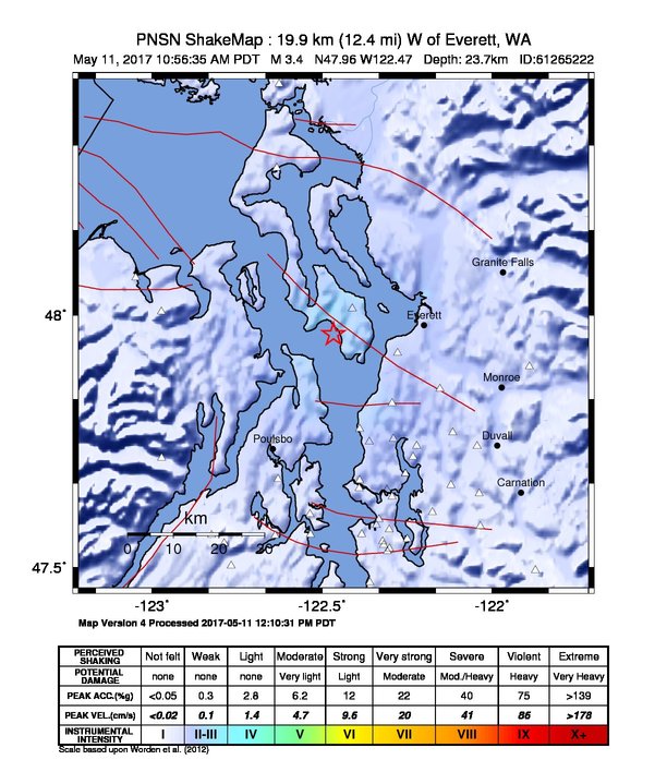
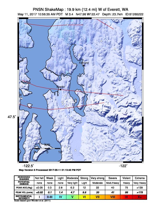
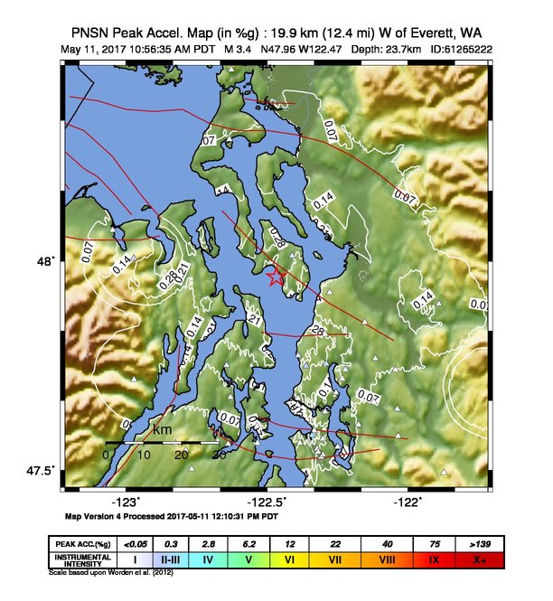
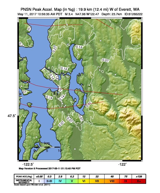
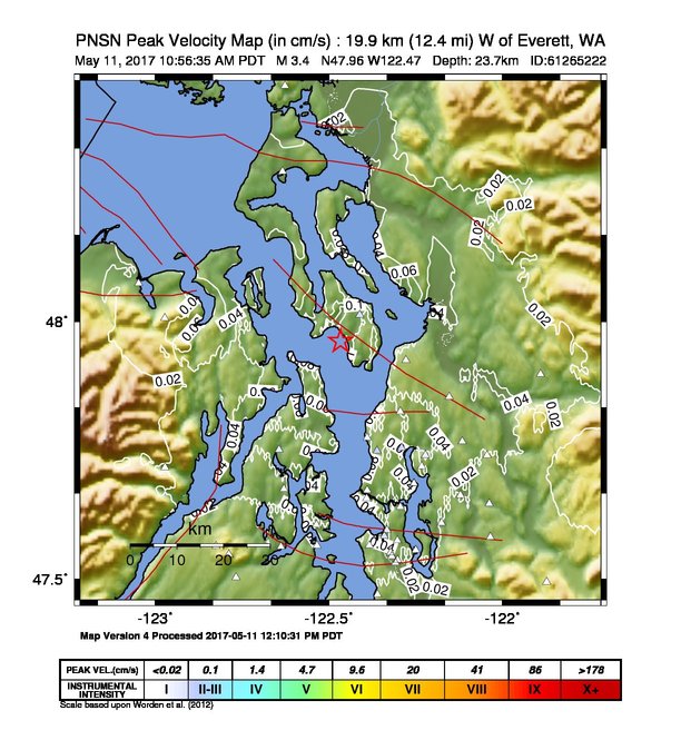
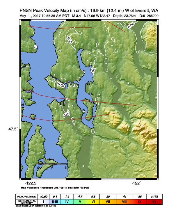
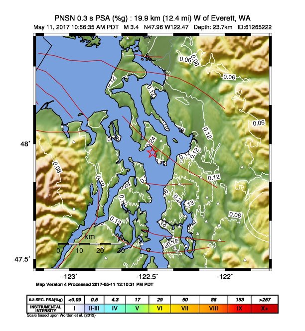
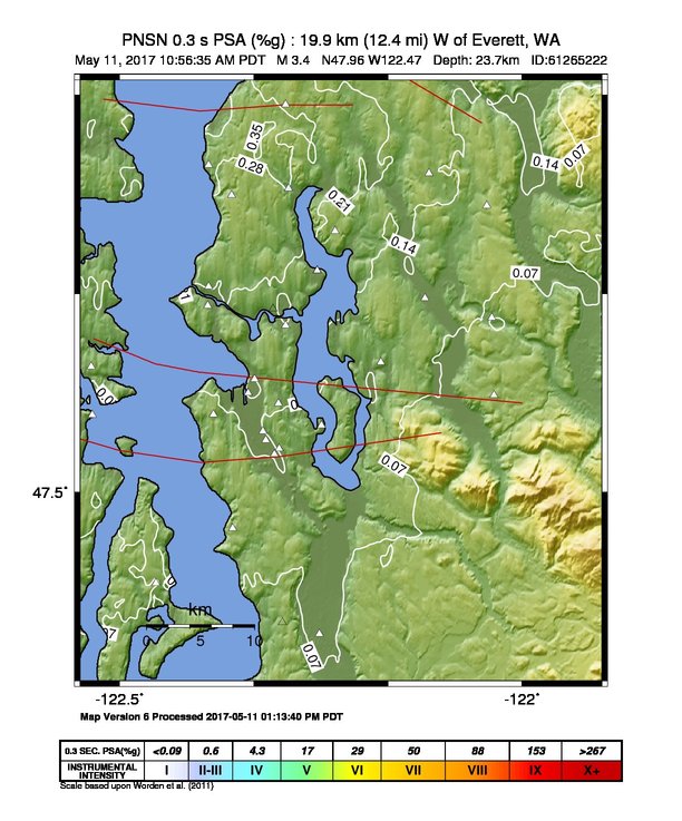
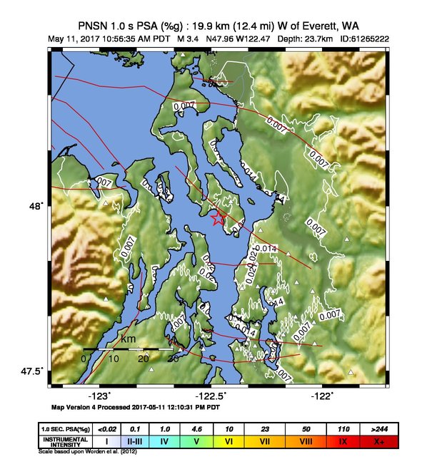
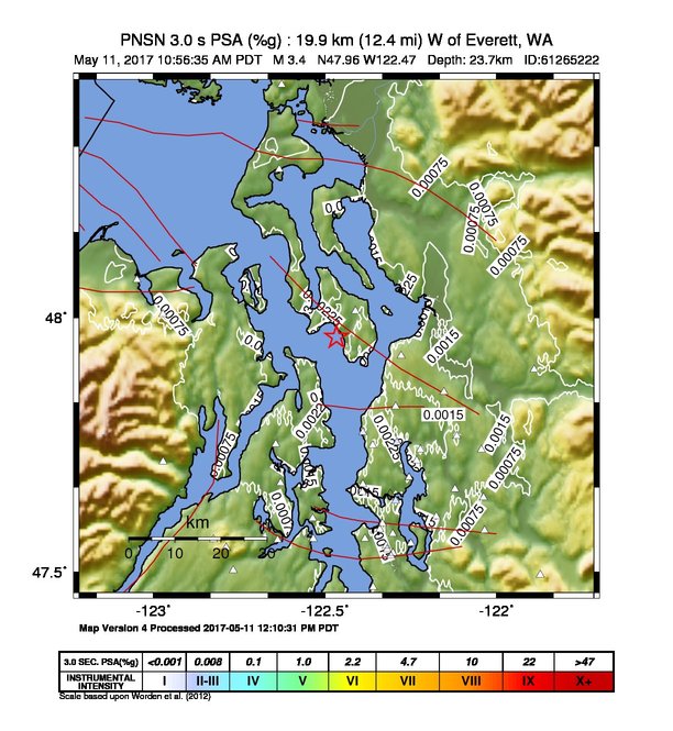
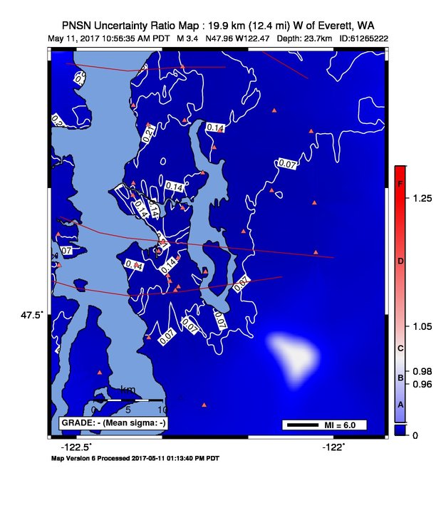
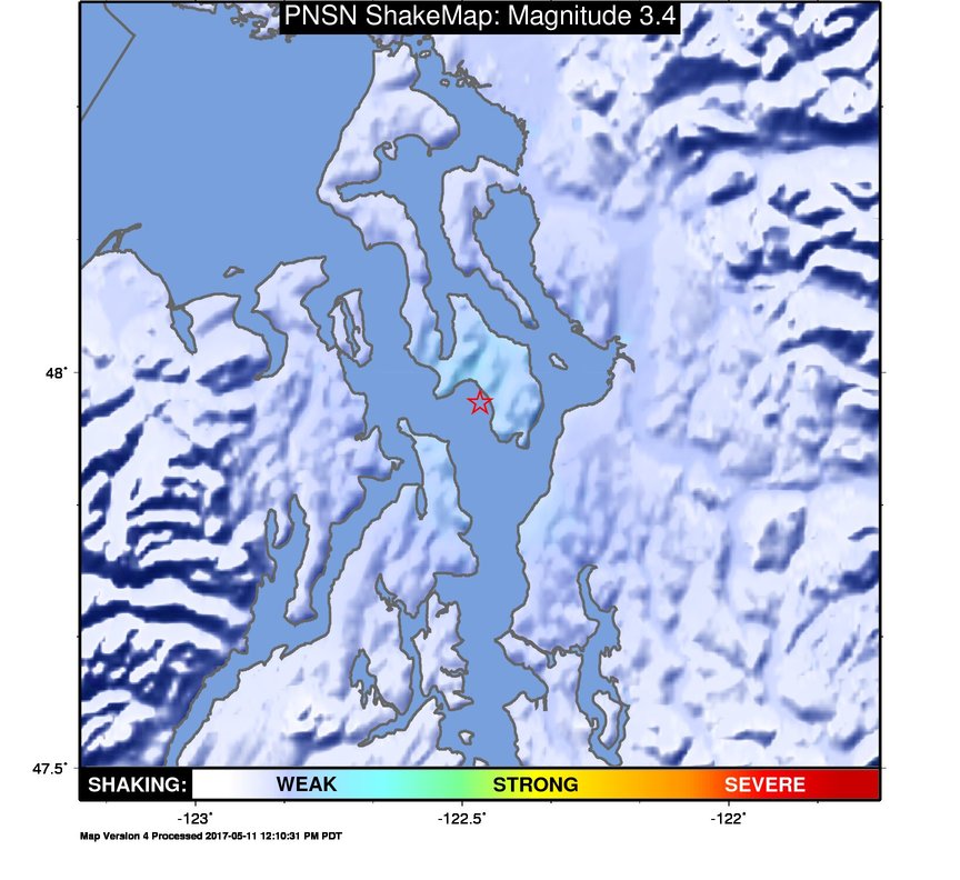
ShakeMap
Time:
Thu May 11, 2017 17:56:35 (UTC)
|
Depth:
23.67 km
|
Event ID:
61265222
|
Location:
47.962, -122.466


Downloads
| Regional | High Resolution Seattle | |
|---|---|---|
| intensity | JPG | PS.ZIP | JPG | PS.ZIP |
| acceleration | JPG | PS.ZIP | JPG | PS.ZIP |
| velocity | JPG | PS.ZIP | JPG | PS.ZIP |
| spectral 0.3 | JPG | PS.ZIP | JPG | PS.ZIP |
| spectral 1.0 | JPG | PS.ZIP | JPG | PS.ZIP |
| spectral 3.0 | JPG | PS.ZIP | JPG | PS.ZIP |
| uncertainty | JPG | PS.ZIP | JPG | PS.ZIP |
| tv map | JPG | PS.ZIP | JPG | PS.ZIP |
| tv map bare | JPG | PS.ZIP | JPG | PS.ZIP |
| tv info sheet | TXT | TXT |
| grid | XYZ.ZIP | XML.ZIP | XYZ.ZIP | XML.ZIP |
| gis | ZIP | ZIP |
| station | TXT | XML | TXT | XML |
| metadata | TXT | TXT |
Earthquake
| Event ID | Magnitude | Date | Time | Lat | Lon | Depth |
| 61265222 | 3.4 | // | :: | N47.96170 | W122.46630 | 23.67 km |
| Magnitude Bias: | MMI | PGA | PGV | PSA 0.3 | PSA 1.0 | PSA 3.0 |
| -1.14 | 0.29 | 0.19 | 0.28 | 0.19 | 0.18 |
Seismic Stations
| UW.ALCT: | Alcott School, Redmond ANSS-SMO | Agency: Pacific Northwest Regional Seismic Network | |||
| Lat: 47.64690 Lon: -122.03770 Distance: 53.01 km from source | |||||
| Intensity: 1.0 | |||||
| Station Comp | Max Vel (cm/s) | Max Acc (%g) | PSA: 0.3 sec (%g) | 1.0 sec (%g) | 3.0 sec (%g) |
| --.ENN | 0.0111 | 0.0284 | 0.0573 | 0.0071 | 0.0007 |
| --.ENE | 0.0077 | 0.0319 | 0.0477 | 0.0052 | 0.0004 |
| UW.BABE: | Bainbridge School ANSS-SMO | Agency: Pacific Northwest Regional Seismic Network | |||
| Lat: 47.60583 Lon: -122.53528 Distance: 46.40 km from source | |||||
| Intensity: 1.0 | |||||
| Station Comp | Max Vel (cm/s) | Max Acc (%g) | PSA: 0.3 sec (%g) | 1.0 sec (%g) | 3.0 sec (%g) |
| --.ENN | 0.0166 | 0.0436 | 0.0736 | 0.0071 | 0.0014 |
| --.ENE | 0.0149 | 0.0496 | 0.0679 | 0.0060 | 0.0012 |
| UW.BEVT: | Boeing Everett ANSS-SMO | Agency: Pacific Northwest Regional Seismic Network | |||
| Lat: 47.92497 Lon: -122.27811 Distance: 27.81 km from source | |||||
| Intensity: 1.1 | |||||
| Station Comp | Max Vel (cm/s) | Max Acc (%g) | PSA: 0.3 sec (%g) | 1.0 sec (%g) | 3.0 sec (%g) |
| --.ENN | 0.0182 | 0.0630 | 0.0694 | 0.0047 | 0.0010 |
| --.ENE | 0.0173 | 0.0524 | 0.0488 | 0.0071 | 0.0009 |
| UW.BLN: | Blyn Mt. | Agency: Pacific Northwest Regional Seismic Network | |||
| Lat: 48.00662 Lon: -122.97265 Distance: 44.78 km from source | |||||
| Intensity: 1.9 | |||||
| Station Comp | Max Vel (cm/s) | Max Acc (%g) | PSA: 0.3 sec (%g) | 1.0 sec (%g) | 3.0 sec (%g) |
| --.ENN | 0.0413 | 0.2665 | 0.0970 | 0.0045 | 0.0005 |
| --.ENE | 0.0210 | 0.1615 | 0.0356 | 0.0024 | 0.0004 |
| UW.BRKS: | Brookside ANSS-SMO | Agency: Pacific Northwest Regional Seismic Network | |||
| Lat: 47.75520 Lon: -122.29013 Distance: 35.50 km from source | |||||
| Intensity: 2.6 | |||||
| Station Comp | Max Vel (cm/s) | Max Acc (%g) | PSA: 0.3 sec (%g) | 1.0 sec (%g) | 3.0 sec (%g) |
| --.ENN | 0.1066 | 0.3314 | 0.4416 | 0.0357 | 0.0040 |
| --.ENE | 0.1033 | 0.2987 | 0.3212 | 0.0170 | 0.0022 |
| UW.BSFP: | Boeing Fire Protection | Agency: Pacific Northwest Regional Seismic Network | |||
| Lat: 47.53186 Lon: -122.30777 Distance: 54.64 km from source | |||||
| Intensity: 2.0 | |||||
| Station Comp | Max Vel (cm/s) | Max Acc (%g) | PSA: 0.3 sec (%g) | 1.0 sec (%g) | 3.0 sec (%g) |
| --.ENN | 0.0259 | 0.0781 | 0.1052 | 0.0183 | 0.0011 |
| --.ENE | 0.0442 | 0.1315 | 0.2027 | 0.0174 | 0.0010 |
| UW.DOSE: | Dosewallips old TA.C04A, WA | Agency: Pacific Northwest Regional Seismic Network | |||
| Lat: 47.71720 Lon: -122.97180 Distance: 52.18 km from source | |||||
| Intensity: 1.4 | |||||
| Station Comp | Max Vel (cm/s) | Max Acc (%g) | PSA: 0.3 sec (%g) | 1.0 sec (%g) | 3.0 sec (%g) |
| --.BHE | 0.0245 | 0.1003 | 0.0732 | 0.0027 | 0.0003 |
| --.BHN | 0.0212 | 0.1236 | 0.0508 | 0.0023 | 0.0002 |
| UW.EARN: | East Ridge ES ANSS-SMO | Agency: Pacific Northwest Regional Seismic Network | |||
| Lat: 47.74090 Lon: -122.04380 Distance: 46.44 km from source | |||||
| Intensity: 1.4 | |||||
| Station Comp | Max Vel (cm/s) | Max Acc (%g) | PSA: 0.3 sec (%g) | 1.0 sec (%g) | 3.0 sec (%g) |
| --.ENN | 0.0255 | 0.0918 | 0.0991 | 0.0091 | 0.0012 |
| --.ENE | 0.0156 | 0.0478 | 0.0888 | 0.0068 | 0.0007 |
| UW.ELW: | EchoLakeBPA | Agency: Pacific Northwest Regional Seismic Network | |||
| Lat: 47.49410 Lon: -121.87267 Distance: 72.35 km from source | |||||
| Intensity: 1.0 | |||||
| Station Comp | Max Vel (cm/s) | Max Acc (%g) | PSA: 0.3 sec (%g) | 1.0 sec (%g) | 3.0 sec (%g) |
| --.ENN | 0.0083 | 0.0247 | 0.0423 | 0.0030 | 0.0003 |
| --.ENE | 0.0080 | 0.0281 | 0.0320 | 0.0020 | 0.0005 |
| UW.ERW: | Mt. Erie, WA, USA | Agency: Pacific Northwest Seismic Network | |||
| Lat: 48.45383 Lon: -122.62612 Distance: 60.79 km from source | |||||
| Intensity: 1.0 | |||||
| Station Comp | Max Vel (cm/s) | Max Acc (%g) | PSA: 0.3 sec (%g) | 1.0 sec (%g) | 3.0 sec (%g) |
| --.HNN | 0.0023 | 0.0119 | 0.0145 | 0.0008 | 0.0001 |
| --.HNE | 0.0027 | 0.0110 | 0.0107 | 0.0012 | 0.0001 |
| UW.EVGW: | Everett Gateway Middle School ANSS-SMO | Agency: Pacific Northwest Regional Seismic Network | |||
| Lat: 47.85440 Lon: -122.15338 Distance: 35.31 km from source | |||||
| Intensity: 1.7 | |||||
| Station Comp | Max Vel (cm/s) | Max Acc (%g) | PSA: 0.3 sec (%g) | 1.0 sec (%g) | 3.0 sec (%g) |
| --.ENN | 0.0300 | 0.0742 | 0.1312 | 0.0117 | 0.0013 |
| --.ENE | 0.0338 | 0.0926 | 0.1213 | 0.0083 | 0.0009 |
| UW.FINN: | Finn Hill Jr High ANSS-SMO | Agency: Pacific Northwest Regional Seismic Network | |||
| Lat: 47.71950 Lon: -122.23220 Distance: 39.89 km from source | |||||
| Intensity: 1.4 | |||||
| Station Comp | Max Vel (cm/s) | Max Acc (%g) | PSA: 0.3 sec (%g) | 1.0 sec (%g) | 3.0 sec (%g) |
| --.ENN | 0.0241 | 0.0418 | 0.0938 | 0.0078 | 0.0007 |
| --.ENE | 0.0135 | 0.0309 | 0.0569 | 0.0086 | 0.0009 |
| UW.GMW: | Gold Mt. | Agency: Pacific Northwest Regional Seismic Network | |||
| Lat: 47.54773 Lon: -122.78759 Distance: 57.06 km from source | |||||
| Intensity: 1.0 | |||||
| Station Comp | Max Vel (cm/s) | Max Acc (%g) | PSA: 0.3 sec (%g) | 1.0 sec (%g) | 3.0 sec (%g) |
| --.ENN | 0.0091 | 0.0501 | 0.0204 | 0.0010 | 0.0002 |
| --.ENE | 0.0071 | 0.0473 | 0.0190 | 0.0009 | 0.0002 |
| UW.GNW: | Green Mountain (BB) CREST SMO | Agency: Pacific Northwest Regional Seismic Network | |||
| Lat: 47.56413 Lon: -122.82498 Distance: 56.86 km from source | |||||
| Intensity: 1.0 | |||||
| Station Comp | Max Vel (cm/s) | Max Acc (%g) | PSA: 0.3 sec (%g) | 1.0 sec (%g) | 3.0 sec (%g) |
| --.BHE | 0.0079 | 0.0409 | 0.0190 | 0.0013 | 0.0001 |
| --.BHN | 0.0053 | 0.0303 | 0.0171 | 0.0009 | 0.0001 |
| UW.GTWN: | Georgetown Playfield ANSS-SMO | Agency: Pacific Northwest Regional Seismic Network | |||
| Lat: 47.55121 Lon: -122.32201 Distance: 52.54 km from source | |||||
| Intensity: 1.3 | |||||
| Station Comp | Max Vel (cm/s) | Max Acc (%g) | PSA: 0.3 sec (%g) | 1.0 sec (%g) | 3.0 sec (%g) |
| --.ENN | 0.0225 | 0.0724 | 0.2129 | 0.0194 | 0.0009 |
| --.ENE | 0.0201 | 0.0664 | 0.1201 | 0.0116 | 0.0006 |
| UW.HOLY: | Holy Rosary ANSS-SMO | Agency: Pacific Northwest Regional Seismic Network | |||
| Lat: 47.56540 Lon: -122.38360 Distance: 50.40 km from source | |||||
| Intensity: 1.0 | |||||
| Station Comp | Max Vel (cm/s) | Max Acc (%g) | PSA: 0.3 sec (%g) | 1.0 sec (%g) | 3.0 sec (%g) |
| --.ENN | 0.0114 | 0.0298 | 0.0690 | 0.0054 | 0.0006 |
| --.ENE | 0.0128 | 0.0284 | 0.0629 | 0.0067 | 0.0005 |
| UW.KCAM: | King County Airport Maint. Shop, ANSS-SMO | Agency: Pacific Northwest Regional Seismic Network | |||
| Lat: 47.54400 Lon: -122.31850 Distance: 53.29 km from source | |||||
| Intensity: 1.2 | |||||
| Station Comp | Max Vel (cm/s) | Max Acc (%g) | PSA: 0.3 sec (%g) | 1.0 sec (%g) | 3.0 sec (%g) |
| --.ENN | 0.0170 | 0.0383 | 0.1075 | 0.0130 | 0.0010 |
| --.ENE | 0.0188 | 0.0459 | 0.1141 | 0.0126 | 0.0006 |
| UW.KDK: | Coastal Environmental, Seattle ANSS-SMO | Agency: Pacific Northwest Regional Seismic Network | |||
| Lat: 47.59520 Lon: -122.33223 Distance: 48.18 km from source | |||||
| Intensity: 2.3 | |||||
| Station Comp | Max Vel (cm/s) | Max Acc (%g) | PSA: 0.3 sec (%g) | 1.0 sec (%g) | 3.0 sec (%g) |
| --.ENN | 0.0621 | 0.1171 | 0.2942 | 0.0239 | 0.0022 |
| --.ENE | 0.0317 | 0.0740 | 0.1506 | 0.0144 | 0.0015 |
| UW.KIMB: | Kimball School ANSS-SMO | Agency: Pacific Northwest Regional Seismic Network | |||
| Lat: 47.57480 Lon: -122.30280 Distance: 50.60 km from source | |||||
| Intensity: 1.3 | |||||
| Station Comp | Max Vel (cm/s) | Max Acc (%g) | PSA: 0.3 sec (%g) | 1.0 sec (%g) | 3.0 sec (%g) |
| --.ENN | 0.0217 | 0.0490 | 0.0908 | 0.0084 | 0.0010 |
| --.ENE | 0.0219 | 0.0580 | 0.1140 | 0.0080 | 0.0009 |
| UW.KIMR: | Kitsap Mod Risk ANSS-SMO | Agency: Pacific Northwest Regional Seismic Network | |||
| Lat: 47.50306 Lon: -122.76722 Distance: 60.56 km from source | |||||
| Intensity: 1.0 | |||||
| Station Comp | Max Vel (cm/s) | Max Acc (%g) | PSA: 0.3 sec (%g) | 1.0 sec (%g) | 3.0 sec (%g) |
| --.ENN | 0.0106 | 0.0497 | 0.0193 | 0.0019 | 0.0003 |
| --.ENE | 0.0120 | 0.0366 | 0.0412 | 0.0018 | 0.0007 |
| UW.KINR: | Kitsap Road Shed ANSS-SMO | Agency: Pacific Northwest Regional Seismic Network | |||
| Lat: 47.75167 Lon: -122.64306 Distance: 35.77 km from source | |||||
| Intensity: 2.2 | |||||
| Station Comp | Max Vel (cm/s) | Max Acc (%g) | PSA: 0.3 sec (%g) | 1.0 sec (%g) | 3.0 sec (%g) |
| --.ENN | 0.0602 | 0.1999 | 0.2356 | 0.0126 | 0.0012 |
| --.ENE | 0.0474 | 0.1738 | 0.1794 | 0.0088 | 0.0013 |
| UW.KITP: | Kitsap Treatment Plant ANSS-SMO | Agency: Pacific Northwest Regional Seismic Network | |||
| Lat: 47.67520 Lon: -122.62974 Distance: 41.52 km from source | |||||
| Intensity: 1.6 | |||||
| Station Comp | Max Vel (cm/s) | Max Acc (%g) | PSA: 0.3 sec (%g) | 1.0 sec (%g) | 3.0 sec (%g) |
| --.ENN | 0.0292 | 0.0828 | 0.1329 | 0.0083 | 0.0009 |
| --.ENE | 0.0195 | 0.1077 | 0.0592 | 0.0035 | 0.0005 |
| UW.LAWT: | Lawton School ANSS-SMO | Agency: Pacific Northwest Regional Seismic Network | |||
| Lat: 47.65694 Lon: -122.39062 Distance: 41.72 km from source | |||||
| Intensity: 1.6 | |||||
| Station Comp | Max Vel (cm/s) | Max Acc (%g) | PSA: 0.3 sec (%g) | 1.0 sec (%g) | 3.0 sec (%g) |
| --.ENN | 0.0284 | 0.0902 | 0.1723 | 0.0140 | 0.0009 |
| --.ENE | 0.0288 | 0.0931 | 0.1349 | 0.0095 | 0.0007 |
| UW.LEOT: | Leota J. High ANSS-SMO | Agency: Pacific Northwest Regional Seismic Network | |||
| Lat: 47.76790 Lon: -122.11560 Distance: 41.34 km from source | |||||
| Intensity: 2.0 | |||||
| Station Comp | Max Vel (cm/s) | Max Acc (%g) | PSA: 0.3 sec (%g) | 1.0 sec (%g) | 3.0 sec (%g) |
| --.ENN | 0.0452 | 0.1336 | 0.1778 | 0.0153 | 0.0024 |
| --.ENE | 0.0242 | 0.0931 | 0.0861 | 0.0086 | 0.0010 |
| UW.LYNC: | Lynnwood City Hall, ANSS-SMO | Agency: Pacific Northwest Regional Seismic Network | |||
| Lat: 47.82555 Lon: -122.29384 Distance: 30.90 km from source | |||||
| Intensity: 1.9 | |||||
| Station Comp | Max Vel (cm/s) | Max Acc (%g) | PSA: 0.3 sec (%g) | 1.0 sec (%g) | 3.0 sec (%g) |
| --.ENN | 0.0398 | 0.0677 | 0.1265 | 0.0244 | 0.0020 |
| --.ENE | 0.0203 | 0.0685 | 0.0757 | 0.0130 | 0.0011 |
| UW.MARY: | Marymoor Park ANSS-SMO | Agency: Pacific Northwest Regional Seismic Network | |||
| Lat: 47.66334 Lon: -122.12068 Distance: 48.24 km from source | |||||
| Intensity: 1.0 | |||||
| Station Comp | Max Vel (cm/s) | Max Acc (%g) | PSA: 0.3 sec (%g) | 1.0 sec (%g) | 3.0 sec (%g) |
| --.ENN | 0.0141 | 0.0372 | 0.0800 | 0.0101 | 0.0010 |
| --.ENE | 0.0118 | 0.0319 | 0.0685 | 0.0096 | 0.0005 |
| UW.MBPA: | Monroe BPA, WA, USA | Agency: Pacific Northwest Regional Seismic Network | |||
| Lat: 47.89835 Lon: -121.89018 Distance: 49.52 km from source | |||||
| Intensity: 1.6 | |||||
| Station Comp | Max Vel (cm/s) | Max Acc (%g) | PSA: 0.3 sec (%g) | 1.0 sec (%g) | 3.0 sec (%g) |
| --.ENN | 0.0140 | 0.0894 | 0.0596 | 0.0030 | 0.0006 |
| --.ENE | 0.0294 | 0.1457 | 0.0535 | 0.0045 | 0.0008 |
| UW.MNWA: | Manchester, WA | Agency: Pacific Northwest Regional Seismic Network | |||
| Lat: 47.56503 Lon: -122.53414 Distance: 50.31 km from source | |||||
| Intensity: 1.3 | |||||
| Station Comp | Max Vel (cm/s) | Max Acc (%g) | PSA: 0.3 sec (%g) | 1.0 sec (%g) | 3.0 sec (%g) |
| --.ENN | 0.0104 | 0.0719 | 0.0357 | 0.0023 | 0.0003 |
| --.ENE | 0.0209 | 0.1037 | 0.0381 | 0.0040 | 0.0004 |
| UW.MPL: | Maple Valley SMO | Agency: Pacific Northwest Regional Seismic Network | |||
| Lat: 47.68630 Lon: -122.25444 Distance: 41.81 km from source | |||||
| Intensity: 1.0 | |||||
| Station Comp | Max Vel (cm/s) | Max Acc (%g) | PSA: 0.3 sec (%g) | 1.0 sec (%g) | 3.0 sec (%g) |
| --.ENN | 0.0126 | 0.0330 | 0.0698 | 0.0025 | 0.0007 |
| --.ENE | 0.0117 | 0.0281 | 0.0671 | 0.0032 | 0.0007 |
| UW.NIHS: | Inglemoor HS ANSS-SMO | Agency: Pacific Northwest Regional Seismic Network | |||
| Lat: 47.74144 Lon: -122.22141 Distance: 38.65 km from source | |||||
| Intensity: 2.2 | |||||
| Station Comp | Max Vel (cm/s) | Max Acc (%g) | PSA: 0.3 sec (%g) | 1.0 sec (%g) | 3.0 sec (%g) |
| --.ENN | 0.0582 | 0.1577 | 0.2878 | 0.0183 | 0.0022 |
| --.ENE | 0.0275 | 0.0792 | 0.0928 | 0.0093 | 0.0010 |
| UW.NOWS: | NOAA, Seattle Bldg 3-SMO-IDS20 | Agency: Pacific Northwest Regional Seismic Network | |||
| Lat: 47.68630 Lon: -122.25444 Distance: 41.81 km from source | |||||
| Intensity: 2.0 | |||||
| Station Comp | Max Vel (cm/s) | Max Acc (%g) | PSA: 0.3 sec (%g) | 1.0 sec (%g) | 3.0 sec (%g) |
| --.ENN | 0.0469 | 0.1276 | 0.1978 | 0.0150 | 0.0019 |
| --.ENE | 0.0175 | 0.0519 | 0.0647 | 0.0075 | 0.0006 |
| UW.PIER: | Pier 30, Seattle, WA | Agency: Pacific Northwest Seismic Network | |||
| Lat: 47.58350 Lon: -122.34020 Distance: 49.17 km from source | |||||
| Intensity: 2.5 | |||||
| Station Comp | Max Vel (cm/s) | Max Acc (%g) | PSA: 0.3 sec (%g) | 1.0 sec (%g) | 3.0 sec (%g) |
| --.HNN | 0.0532 | 0.6778 | 0.3368 | 0.0228 | 0.0018 |
| --.HNE | 0.0831 | 1.0351 | 0.1798 | 0.0181 | 0.0017 |
| UW.PNLK: | Pine Lake JH ANSS-SMO | Agency: Pacific Northwest Seismic Network | |||
| Lat: 47.58162 Lon: -122.03483 Distance: 58.19 km from source | |||||
| Intensity: 1.0 | |||||
| Station Comp | Max Vel (cm/s) | Max Acc (%g) | PSA: 0.3 sec (%g) | 1.0 sec (%g) | 3.0 sec (%g) |
| --.HNN | 0.0102 | 0.0318 | 0.0336 | 0.0045 | 0.0004 |
| --.HNE | 0.0081 | 0.0258 | 0.0281 | 0.0043 | 0.0003 |
| UW.PSNS: | Puget Sound Naval Shipyard - ANSS SMO | Agency: Pacific Northwest Regional Seismic Network | |||
| Lat: 47.56273 Lon: -122.63763 Distance: 51.89 km from source | |||||
| Intensity: 1.0 | |||||
| Station Comp | Max Vel (cm/s) | Max Acc (%g) | PSA: 0.3 sec (%g) | 1.0 sec (%g) | 3.0 sec (%g) |
| --.ENN | 0.0079 | 0.0296 | 0.0326 | 0.0030 | 0.0003 |
| --.ENE | 0.0086 | 0.0335 | 0.0724 | 0.0029 | 0.0003 |
| UW.QADA: | NW 61st St, Ballard, WA | Agency: Pacific Northwest Regional Seismic Network | |||
| Lat: 47.67280 Lon: -122.38963 Distance: 40.31 km from source | |||||
| Intensity: 1.8 | |||||
| Station Comp | Max Vel (cm/s) | Max Acc (%g) | PSA: 0.3 sec (%g) | 1.0 sec (%g) | 3.0 sec (%g) |
| 01.HNN | 0.0364 | 0.1018 | 0.1869 | 0.0127 | 0.0014 |
| 01.HNE | 0.0279 | 0.0951 | 0.1192 | 0.0049 | 0.0011 |
| 01.HNZ | 0.0187 | 0.0771 | 0.1060 | 0.0040 | 0.0014 |
| UW.QARB: | UW Arboretum, Seattle, WA | Agency: Pacific Northwest Regional Seismic Network | |||
| Lat: 47.64031 Lon: -122.29381 Distance: 44.76 km from source | |||||
| Intensity: 2.1 | |||||
| Station Comp | Max Vel (cm/s) | Max Acc (%g) | PSA: 0.3 sec (%g) | 1.0 sec (%g) | 3.0 sec (%g) |
| 01.HNN | 0.0507 | 0.1361 | 0.1628 | 0.0117 | 0.0050 |
| 01.HNE | 0.0289 | 0.1004 | 0.0804 | 0.0084 | 0.0015 |
| 01.HNZ | 0.0142 | 0.0822 | 0.0565 | 0.0043 | 0.0017 |
| UW.QLBR: | SW 149th St, Burien, WA | Agency: Pacific Northwest Regional Seismic Network | |||
| Lat: 47.46955 Lon: -122.35948 Distance: 60.16 km from source | |||||
| Intensity: 1.0 | |||||
| Station Comp | Max Vel (cm/s) | Max Acc (%g) | PSA: 0.3 sec (%g) | 1.0 sec (%g) | 3.0 sec (%g) |
| 01.HNN | 0.0067 | 0.0233 | 0.0299 | 0.0031 | 0.0020 |
| 01.HNE | 0.0117 | 0.0273 | 0.0517 | 0.0043 | 0.0019 |
| 01.HNZ | 0.0057 | 0.0384 | 0.0250 | 0.0026 | 0.0016 |
| UW.QRMB: | NW 201st Place, Shoreline, WA | Agency: Pacific Northwest Regional Seismic Network | |||
| Lat: 47.77483 Lon: -122.38951 Distance: 32.01 km from source | |||||
| Intensity: 2.1 | |||||
| Station Comp | Max Vel (cm/s) | Max Acc (%g) | PSA: 0.3 sec (%g) | 1.0 sec (%g) | 3.0 sec (%g) |
| 01.HNN | 0.0520 | 0.2581 | 0.2378 | 0.0213 | 0.0030 |
| 01.HNE | 0.0511 | 0.1628 | 0.1494 | 0.0088 | 0.0023 |
| 01.HNZ | 0.0330 | 0.1481 | 0.1900 | 0.0090 | 0.0014 |
| UW.SCC: | Shoreline CC ANSS-SMO | Agency: Pacific Northwest Regional Seismic Network | |||
| Lat: 47.74965 Lon: -122.36105 Distance: 34.32 km from source | |||||
| Intensity: 2.7 | |||||
| Station Comp | Max Vel (cm/s) | Max Acc (%g) | PSA: 0.3 sec (%g) | 1.0 sec (%g) | 3.0 sec (%g) |
| --.ENN | 0.0494 | 0.2514 | 0.2478 | 0.0172 | 0.0021 |
| --.ENE | 0.1196 | 0.4986 | 0.4226 | 0.0210 | 0.0018 |
| UW.SEA: | Seattle (Wood Anderson SMO) | Agency: Pacific Northwest Regional Seismic Network | |||
| Lat: 47.65421 Lon: -122.30938 Distance: 43.20 km from source | |||||
| Intensity: NaN | |||||
| Station Comp | Max Vel (cm/s) | Max Acc (%g) | PSA: 0.3 sec (%g) | 1.0 sec (%g) | 3.0 sec (%g) |
| --.ENN | 0.0006 -G | 0.0019 -G | 0.0008 -G | 0.0002 -G | 0.0001 -G |
| --.ENE | 0.0112 | 0.0505 | 0.0542 | 0.0065 | 0.0006 |
| UW.SP2: | Seward Park, Seattle SMO-IDS24 BB(7/97) | Agency: Pacific Northwest Regional Seismic Network | |||
| Lat: 47.55629 Lon: -122.24923 Distance: 53.44 km from source | |||||
| Intensity: 1.4 | |||||
| Station Comp | Max Vel (cm/s) | Max Acc (%g) | PSA: 0.3 sec (%g) | 1.0 sec (%g) | 3.0 sec (%g) |
| --.BHE | 0.0003 | 0.0008 | 0.0014 | 0.0001 | 0.0000 |
| --.BHN | 0.0241 | 0.1022 | 0.1109 | 0.0066 | 0.0006 |
| UW.SQM: | PNNL - Sequim, WA, USA | Agency: Pacific Northwest Seismic Network | |||
| Lat: 48.07368 Lon: -123.04806 Distance: 50.87 km from source | |||||
| Intensity: 1.1 | |||||
| Station Comp | Max Vel (cm/s) | Max Acc (%g) | PSA: 0.3 sec (%g) | 1.0 sec (%g) | 3.0 sec (%g) |
| --.ENN | 0.0161 | 0.0407 | 0.0567 | 0.0081 | 0.0014 |
| --.ENE | 0.0169 | 0.0575 | 0.1141 | 0.0083 | 0.0007 |
| UW.SVOH: | Skagit Valley CC ANSS-SMO | Agency: Pacific Northwest Regional Seismic Network | |||
| Lat: 48.28920 Lon: -122.63316 Distance: 45.16 km from source | |||||
| Intensity: 1.6 | |||||
| Station Comp | Max Vel (cm/s) | Max Acc (%g) | PSA: 0.3 sec (%g) | 1.0 sec (%g) | 3.0 sec (%g) |
| --.ENN | 0.0126 | 0.0691 | 0.0745 | 0.0041 | 0.0007 |
| --.ENE | 0.0292 | 0.0748 | 0.1395 | 0.0054 | 0.0009 |
| UW.SWID: | South Whidbey SD ANSS-SMO | Agency: Pacific Northwest Regional Seismic Network | |||
| Lat: 48.01285 Lon: -122.41101 Distance: 24.69 km from source | |||||
| Intensity: 2.5 | |||||
| Station Comp | Max Vel (cm/s) | Max Acc (%g) | PSA: 0.3 sec (%g) | 1.0 sec (%g) | 3.0 sec (%g) |
| --.ENN | 0.0870 | 0.3110 | 0.1889 | 0.0210 | 0.0023 |
| --.ENE | 0.0571 | 0.1579 | 0.1351 | 0.0164 | 0.0016 |
| UW.TKCO: | King Co EOC - SMO | Agency: Pacific Northwest Regional Seismic Network | |||
| Lat: 47.53668 Lon: -122.30165 Distance: 54.27 km from source | |||||
| Intensity: 1.5 | |||||
| Station Comp | Max Vel (cm/s) | Max Acc (%g) | PSA: 0.3 sec (%g) | 1.0 sec (%g) | 3.0 sec (%g) |
| --.ENN | 0.0138 | 0.0450 | 0.1220 | 0.0064 | 0.0006 |
| --.ENE | 0.0275 | 0.0610 | 0.1182 | 0.0114 | 0.0007 |
| UW.WISC: | Wilburton Center ANSS-SMO | Agency: Pacific Northwest Regional Seismic Network | |||
| Lat: 47.60926 Lon: -122.17553 Distance: 50.68 km from source | |||||
| Intensity: 1.4 | |||||
| Station Comp | Max Vel (cm/s) | Max Acc (%g) | PSA: 0.3 sec (%g) | 1.0 sec (%g) | 3.0 sec (%g) |
| --.ENN | 0.0236 | 0.0842 | 0.0934 | 0.0068 | 0.0009 |
| --.ENE | 0.0191 | 0.0627 | 0.0638 | 0.0042 | 0.0004 |
Earthquake
| Event ID | Magnitude | Date | Time | Lat | Lon | Depth |
| 61265222 | 3.4 | // | :: | N47.96170 | W122.46630 | 23.67 km |
| Magnitude Bias: | MMI | PGA | PGV | PSA 0.3 | PSA 1.0 | PSA 3.0 |
| -0.98 | 0.30 | 0.25 | 0.32 | 0.27 | 0.24 |
Seismic Stations
| UW.ALCT: | Alcott School, Redmond ANSS-SMO | Agency: Pacific Northwest Regional Seismic Network | |||
| Lat: 47.64690 Lon: -122.03770 Distance: 53.01 km from epicenter | |||||
| Intensity: 1.0 | |||||
| Station Comp | Max Vel (cm/s) | Max Acc (%g) | PSA: 0.3 sec (%g) | 1.0 sec (%g) | 3.0 sec (%g) |
| --.ENN | 0.0111 | 0.0284 | 0.0573 | 0.0071 | 0.0007 |
| --.ENE | 0.0077 | 0.0319 | 0.0477 | 0.0052 | 0.0004 |
| UW.BABE: | Bainbridge School ANSS-SMO | Agency: Pacific Northwest Regional Seismic Network | |||
| Lat: 47.60583 Lon: -122.53528 Distance: 46.40 km from epicenter | |||||
| Intensity: 1.0 | |||||
| Station Comp | Max Vel (cm/s) | Max Acc (%g) | PSA: 0.3 sec (%g) | 1.0 sec (%g) | 3.0 sec (%g) |
| --.ENN | 0.0166 | 0.0436 | 0.0736 | 0.0071 | 0.0014 |
| --.ENE | 0.0149 | 0.0496 | 0.0679 | 0.0060 | 0.0012 |
| UW.BRKS: | Brookside ANSS-SMO | Agency: Pacific Northwest Regional Seismic Network | |||
| Lat: 47.75520 Lon: -122.29013 Distance: 35.50 km from epicenter | |||||
| Intensity: 2.6 | |||||
| Station Comp | Max Vel (cm/s) | Max Acc (%g) | PSA: 0.3 sec (%g) | 1.0 sec (%g) | 3.0 sec (%g) |
| --.ENN | 0.1066 | 0.3314 | 0.4416 | 0.0357 | 0.0040 |
| --.ENE | 0.1033 | 0.2987 | 0.3212 | 0.0170 | 0.0022 |
| UW.BSFP: | Boeing Fire Protection | Agency: Pacific Northwest Regional Seismic Network | |||
| Lat: 47.53186 Lon: -122.30777 Distance: 54.64 km from epicenter | |||||
| Intensity: 2.0 | |||||
| Station Comp | Max Vel (cm/s) | Max Acc (%g) | PSA: 0.3 sec (%g) | 1.0 sec (%g) | 3.0 sec (%g) |
| --.ENN | 0.0259 | 0.0781 | 0.1052 | 0.0183 | 0.0011 |
| --.ENE | 0.0442 | 0.1315 | 0.2027 | 0.0174 | 0.0010 |
| UW.EARN: | East Ridge ES ANSS-SMO | Agency: Pacific Northwest Regional Seismic Network | |||
| Lat: 47.74090 Lon: -122.04380 Distance: 46.44 km from epicenter | |||||
| Intensity: 1.4 | |||||
| Station Comp | Max Vel (cm/s) | Max Acc (%g) | PSA: 0.3 sec (%g) | 1.0 sec (%g) | 3.0 sec (%g) |
| --.ENN | 0.0255 | 0.0918 | 0.0991 | 0.0091 | 0.0012 |
| --.ENE | 0.0156 | 0.0478 | 0.0888 | 0.0068 | 0.0007 |
| UW.FINN: | Finn Hill Jr High ANSS-SMO | Agency: Pacific Northwest Regional Seismic Network | |||
| Lat: 47.71950 Lon: -122.23220 Distance: 39.89 km from epicenter | |||||
| Intensity: 1.4 | |||||
| Station Comp | Max Vel (cm/s) | Max Acc (%g) | PSA: 0.3 sec (%g) | 1.0 sec (%g) | 3.0 sec (%g) |
| --.ENN | 0.0241 | 0.0418 | 0.0938 | 0.0078 | 0.0007 |
| --.ENE | 0.0135 | 0.0309 | 0.0569 | 0.0086 | 0.0009 |
| UW.GTWN: | Georgetown Playfield ANSS-SMO | Agency: Pacific Northwest Regional Seismic Network | |||
| Lat: 47.55121 Lon: -122.32201 Distance: 52.54 km from epicenter | |||||
| Intensity: 1.3 | |||||
| Station Comp | Max Vel (cm/s) | Max Acc (%g) | PSA: 0.3 sec (%g) | 1.0 sec (%g) | 3.0 sec (%g) |
| --.ENN | 0.0225 | 0.0724 | 0.2129 | 0.0194 | 0.0009 |
| --.ENE | 0.0201 | 0.0664 | 0.1201 | 0.0116 | 0.0006 |
| UW.HICC: | Highline CC ANSS-SMO | Agency: Pacific Northwest Regional Seismic Network | |||
| Lat: 47.39012 Lon: -122.29790 Distance: 68.98 km from epicenter | |||||
| Intensity: NaN | |||||
| Station Comp | Max Vel (cm/s) | Max Acc (%g) | PSA: 0.3 sec (%g) | 1.0 sec (%g) | 3.0 sec (%g) |
| --.ENN | 0.0039 -G | 0.0093 -G | 0.0255 -G | 0.0022 -G | 0.0007 -G |
| --.ENE | 0.0037 -G | 0.0081 -G | 0.0183 -G | 0.0022 -G | 0.0006 -G |
| UW.HOLY: | Holy Rosary ANSS-SMO | Agency: Pacific Northwest Regional Seismic Network | |||
| Lat: 47.56540 Lon: -122.38360 Distance: 50.40 km from epicenter | |||||
| Intensity: 1.0 | |||||
| Station Comp | Max Vel (cm/s) | Max Acc (%g) | PSA: 0.3 sec (%g) | 1.0 sec (%g) | 3.0 sec (%g) |
| --.ENN | 0.0114 | 0.0298 | 0.0690 | 0.0054 | 0.0006 |
| --.ENE | 0.0128 | 0.0284 | 0.0629 | 0.0067 | 0.0005 |
| UW.KCAM: | King County Airport Maint. Shop, ANSS-SMO | Agency: Pacific Northwest Regional Seismic Network | |||
| Lat: 47.54400 Lon: -122.31850 Distance: 53.29 km from epicenter | |||||
| Intensity: 1.2 | |||||
| Station Comp | Max Vel (cm/s) | Max Acc (%g) | PSA: 0.3 sec (%g) | 1.0 sec (%g) | 3.0 sec (%g) |
| --.ENN | 0.0170 | 0.0383 | 0.1075 | 0.0130 | 0.0010 |
| --.ENE | 0.0188 | 0.0459 | 0.1141 | 0.0126 | 0.0006 |
| UW.KDK: | Coastal Environmental, Seattle ANSS-SMO | Agency: Pacific Northwest Regional Seismic Network | |||
| Lat: 47.59520 Lon: -122.33223 Distance: 48.18 km from epicenter | |||||
| Intensity: 2.3 | |||||
| Station Comp | Max Vel (cm/s) | Max Acc (%g) | PSA: 0.3 sec (%g) | 1.0 sec (%g) | 3.0 sec (%g) |
| --.ENN | 0.0621 | 0.1171 | 0.2942 | 0.0239 | 0.0022 |
| --.ENE | 0.0317 | 0.0740 | 0.1506 | 0.0144 | 0.0015 |
| UW.KIMB: | Kimball School ANSS-SMO | Agency: Pacific Northwest Regional Seismic Network | |||
| Lat: 47.57480 Lon: -122.30280 Distance: 50.60 km from epicenter | |||||
| Intensity: 1.3 | |||||
| Station Comp | Max Vel (cm/s) | Max Acc (%g) | PSA: 0.3 sec (%g) | 1.0 sec (%g) | 3.0 sec (%g) |
| --.ENN | 0.0217 | 0.0490 | 0.0908 | 0.0084 | 0.0010 |
| --.ENE | 0.0219 | 0.0580 | 0.1140 | 0.0080 | 0.0009 |
| UW.KNEL: | Kent Elementary ANSS-SMO | Agency: Pacific Northwest Regional Seismic Network | |||
| Lat: 47.38052 Lon: -122.25193 Distance: 70.67 km from epicenter | |||||
| Intensity: 1.0 | |||||
| Station Comp | Max Vel (cm/s) | Max Acc (%g) | PSA: 0.3 sec (%g) | 1.0 sec (%g) | 3.0 sec (%g) |
| --.ENN | 0.0110 | 0.0279 | 0.0554 | 0.0050 | 0.0009 |
| --.ENE | 0.0107 | 0.0277 | 0.0777 | 0.0092 | 0.0005 |
| UW.LAWT: | Lawton School ANSS-SMO | Agency: Pacific Northwest Regional Seismic Network | |||
| Lat: 47.65694 Lon: -122.39062 Distance: 41.72 km from epicenter | |||||
| Intensity: 1.6 | |||||
| Station Comp | Max Vel (cm/s) | Max Acc (%g) | PSA: 0.3 sec (%g) | 1.0 sec (%g) | 3.0 sec (%g) |
| --.ENN | 0.0284 | 0.0902 | 0.1723 | 0.0140 | 0.0009 |
| --.ENE | 0.0288 | 0.0931 | 0.1349 | 0.0095 | 0.0007 |
| UW.LEOT: | Leota J. High ANSS-SMO | Agency: Pacific Northwest Regional Seismic Network | |||
| Lat: 47.76790 Lon: -122.11560 Distance: 41.34 km from epicenter | |||||
| Intensity: 2.0 | |||||
| Station Comp | Max Vel (cm/s) | Max Acc (%g) | PSA: 0.3 sec (%g) | 1.0 sec (%g) | 3.0 sec (%g) |
| --.ENN | 0.0452 | 0.1336 | 0.1778 | 0.0153 | 0.0024 |
| --.ENE | 0.0242 | 0.0931 | 0.0861 | 0.0086 | 0.0010 |
| UW.LYNC: | Lynnwood City Hall, ANSS-SMO | Agency: Pacific Northwest Regional Seismic Network | |||
| Lat: 47.82555 Lon: -122.29384 Distance: 30.90 km from epicenter | |||||
| Intensity: 1.9 | |||||
| Station Comp | Max Vel (cm/s) | Max Acc (%g) | PSA: 0.3 sec (%g) | 1.0 sec (%g) | 3.0 sec (%g) |
| --.ENN | 0.0398 | 0.0677 | 0.1265 | 0.0244 | 0.0020 |
| --.ENE | 0.0203 | 0.0685 | 0.0757 | 0.0130 | 0.0011 |
| UW.MARY: | Marymoor Park ANSS-SMO | Agency: Pacific Northwest Regional Seismic Network | |||
| Lat: 47.66334 Lon: -122.12068 Distance: 48.24 km from epicenter | |||||
| Intensity: 1.0 | |||||
| Station Comp | Max Vel (cm/s) | Max Acc (%g) | PSA: 0.3 sec (%g) | 1.0 sec (%g) | 3.0 sec (%g) |
| --.ENN | 0.0141 | 0.0372 | 0.0800 | 0.0101 | 0.0010 |
| --.ENE | 0.0118 | 0.0319 | 0.0685 | 0.0096 | 0.0005 |
| UW.MNWA: | Manchester, WA | Agency: Pacific Northwest Regional Seismic Network | |||
| Lat: 47.56503 Lon: -122.53414 Distance: 50.31 km from epicenter | |||||
| Intensity: 1.3 | |||||
| Station Comp | Max Vel (cm/s) | Max Acc (%g) | PSA: 0.3 sec (%g) | 1.0 sec (%g) | 3.0 sec (%g) |
| --.ENN | 0.0104 | 0.0719 | 0.0357 | 0.0023 | 0.0003 |
| --.ENE | 0.0209 | 0.1037 | 0.0381 | 0.0040 | 0.0004 |
| UW.MPL: | Maple Valley SMO | Agency: Pacific Northwest Regional Seismic Network | |||
| Lat: 47.68630 Lon: -122.25444 Distance: 41.81 km from epicenter | |||||
| Intensity: 1.0 | |||||
| Station Comp | Max Vel (cm/s) | Max Acc (%g) | PSA: 0.3 sec (%g) | 1.0 sec (%g) | 3.0 sec (%g) |
| --.ENN | 0.0126 | 0.0330 | 0.0698 | 0.0025 | 0.0007 |
| --.ENE | 0.0117 | 0.0281 | 0.0671 | 0.0032 | 0.0007 |
| UW.NIHS: | Inglemoor HS ANSS-SMO | Agency: Pacific Northwest Regional Seismic Network | |||
| Lat: 47.74144 Lon: -122.22141 Distance: 38.65 km from epicenter | |||||
| Intensity: 2.2 | |||||
| Station Comp | Max Vel (cm/s) | Max Acc (%g) | PSA: 0.3 sec (%g) | 1.0 sec (%g) | 3.0 sec (%g) |
| --.ENN | 0.0582 | 0.1577 | 0.2878 | 0.0183 | 0.0022 |
| --.ENE | 0.0275 | 0.0792 | 0.0928 | 0.0093 | 0.0010 |
| UW.NOWS: | NOAA, Seattle Bldg 3-SMO-IDS20 | Agency: Pacific Northwest Regional Seismic Network | |||
| Lat: 47.68630 Lon: -122.25444 Distance: 41.81 km from epicenter | |||||
| Intensity: 2.0 | |||||
| Station Comp | Max Vel (cm/s) | Max Acc (%g) | PSA: 0.3 sec (%g) | 1.0 sec (%g) | 3.0 sec (%g) |
| --.ENN | 0.0469 | 0.1276 | 0.1978 | 0.0150 | 0.0019 |
| --.ENE | 0.0175 | 0.0519 | 0.0647 | 0.0075 | 0.0006 |
| UW.PIER: | Pier 30, Seattle, WA | Agency: Pacific Northwest Seismic Network | |||
| Lat: 47.58350 Lon: -122.34020 Distance: 49.17 km from epicenter | |||||
| Intensity: 2.5 | |||||
| Station Comp | Max Vel (cm/s) | Max Acc (%g) | PSA: 0.3 sec (%g) | 1.0 sec (%g) | 3.0 sec (%g) |
| --.HNN | 0.0532 | 0.6778 | 0.3368 | 0.0228 | 0.0018 |
| --.HNE | 0.0831 | 1.0351 | 0.1798 | 0.0181 | 0.0017 |
| UW.PNLK: | Pine Lake JH ANSS-SMO | Agency: Pacific Northwest Seismic Network | |||
| Lat: 47.58162 Lon: -122.03483 Distance: 58.19 km from epicenter | |||||
| Intensity: 1.0 | |||||
| Station Comp | Max Vel (cm/s) | Max Acc (%g) | PSA: 0.3 sec (%g) | 1.0 sec (%g) | 3.0 sec (%g) |
| --.HNN | 0.0102 | 0.0318 | 0.0336 | 0.0045 | 0.0004 |
| --.HNE | 0.0081 | 0.0258 | 0.0281 | 0.0043 | 0.0003 |
| UW.QADA: | NW 61st St, Ballard, WA | Agency: Pacific Northwest Regional Seismic Network | |||
| Lat: 47.67280 Lon: -122.38963 Distance: 40.31 km from epicenter | |||||
| Intensity: 1.8 | |||||
| Station Comp | Max Vel (cm/s) | Max Acc (%g) | PSA: 0.3 sec (%g) | 1.0 sec (%g) | 3.0 sec (%g) |
| 01.HNN | 0.0364 | 0.1018 | 0.1869 | 0.0127 | 0.0014 |
| 01.HNE | 0.0279 | 0.0951 | 0.1192 | 0.0049 | 0.0011 |
| 01.HNZ | 0.0187 | 0.0771 | 0.1060 | 0.0040 | 0.0014 |
| UW.QARB: | UW Arboretum, Seattle, WA | Agency: Pacific Northwest Regional Seismic Network | |||
| Lat: 47.64031 Lon: -122.29381 Distance: 44.76 km from epicenter | |||||
| Intensity: 2.1 | |||||
| Station Comp | Max Vel (cm/s) | Max Acc (%g) | PSA: 0.3 sec (%g) | 1.0 sec (%g) | 3.0 sec (%g) |
| 01.HNN | 0.0507 | 0.1361 | 0.1628 | 0.0117 | 0.0050 |
| 01.HNE | 0.0289 | 0.1004 | 0.0804 | 0.0084 | 0.0015 |
| 01.HNZ | 0.0142 | 0.0822 | 0.0565 | 0.0043 | 0.0017 |
| UW.QLBR: | SW 149th St, Burien, WA | Agency: Pacific Northwest Regional Seismic Network | |||
| Lat: 47.46955 Lon: -122.35948 Distance: 60.16 km from epicenter | |||||
| Intensity: 1.0 | |||||
| Station Comp | Max Vel (cm/s) | Max Acc (%g) | PSA: 0.3 sec (%g) | 1.0 sec (%g) | 3.0 sec (%g) |
| 01.HNN | 0.0067 | 0.0233 | 0.0299 | 0.0031 | 0.0020 |
| 01.HNE | 0.0117 | 0.0273 | 0.0517 | 0.0043 | 0.0019 |
| 01.HNZ | 0.0057 | 0.0384 | 0.0250 | 0.0026 | 0.0016 |
| UW.QRMB: | NW 201st Place, Shoreline, WA | Agency: Pacific Northwest Regional Seismic Network | |||
| Lat: 47.77483 Lon: -122.38951 Distance: 32.01 km from epicenter | |||||
| Intensity: 2.1 | |||||
| Station Comp | Max Vel (cm/s) | Max Acc (%g) | PSA: 0.3 sec (%g) | 1.0 sec (%g) | 3.0 sec (%g) |
| 01.HNN | 0.0520 | 0.2581 | 0.2378 | 0.0213 | 0.0030 |
| 01.HNE | 0.0511 | 0.1628 | 0.1494 | 0.0088 | 0.0023 |
| 01.HNZ | 0.0330 | 0.1481 | 0.1900 | 0.0090 | 0.0014 |
| UW.SCC: | Shoreline CC ANSS-SMO | Agency: Pacific Northwest Regional Seismic Network | |||
| Lat: 47.74965 Lon: -122.36105 Distance: 34.32 km from epicenter | |||||
| Intensity: 2.7 | |||||
| Station Comp | Max Vel (cm/s) | Max Acc (%g) | PSA: 0.3 sec (%g) | 1.0 sec (%g) | 3.0 sec (%g) |
| --.ENN | 0.0494 | 0.2514 | 0.2478 | 0.0172 | 0.0021 |
| --.ENE | 0.1196 | 0.4986 | 0.4226 | 0.0210 | 0.0018 |
| UW.SEA: | Seattle (Wood Anderson SMO) | Agency: Pacific Northwest Regional Seismic Network | |||
| Lat: 47.65421 Lon: -122.30938 Distance: 43.20 km from epicenter | |||||
| Intensity: NaN | |||||
| Station Comp | Max Vel (cm/s) | Max Acc (%g) | PSA: 0.3 sec (%g) | 1.0 sec (%g) | 3.0 sec (%g) |
| --.ENN | 0.0006 -G | 0.0019 -G | 0.0008 -G | 0.0002 -G | 0.0001 -G |
| --.ENE | 0.0112 | 0.0505 | 0.0542 | 0.0065 | 0.0006 |
| UW.SP2: | Seward Park, Seattle SMO-IDS24 BB(7/97) | Agency: Pacific Northwest Regional Seismic Network | |||
| Lat: 47.55629 Lon: -122.24923 Distance: 53.44 km from epicenter | |||||
| Intensity: 1.4 | |||||
| Station Comp | Max Vel (cm/s) | Max Acc (%g) | PSA: 0.3 sec (%g) | 1.0 sec (%g) | 3.0 sec (%g) |
| --.BHE | 0.0003 | 0.0008 | 0.0014 | 0.0001 | 0.0000 |
| --.BHN | 0.0241 | 0.1022 | 0.1109 | 0.0066 | 0.0006 |
| UW.TKCO: | King Co EOC - SMO | Agency: Pacific Northwest Regional Seismic Network | |||
| Lat: 47.53668 Lon: -122.30165 Distance: 54.27 km from epicenter | |||||
| Intensity: 1.5 | |||||
| Station Comp | Max Vel (cm/s) | Max Acc (%g) | PSA: 0.3 sec (%g) | 1.0 sec (%g) | 3.0 sec (%g) |
| --.ENN | 0.0138 | 0.0450 | 0.1220 | 0.0064 | 0.0006 |
| --.ENE | 0.0275 | 0.0610 | 0.1182 | 0.0114 | 0.0007 |
| UW.VVHS: | Vashon HS ANSS-SMO | Agency: Pacific Northwest Regional Seismic Network | |||
| Lat: 47.42345 Lon: -122.45488 Distance: 64.37 km from epicenter | |||||
| Intensity: 1.0 | |||||
| Station Comp | Max Vel (cm/s) | Max Acc (%g) | PSA: 0.3 sec (%g) | 1.0 sec (%g) | 3.0 sec (%g) |
| --.ENN | 0.0095 | 0.0554 | 0.0322 | 0.0038 | 0.0007 |
| --.ENE | 0.0150 | 0.0666 | 0.0863 | 0.0056 | 0.0008 |
| UW.WISC: | Wilburton Center ANSS-SMO | Agency: Pacific Northwest Regional Seismic Network | |||
| Lat: 47.60926 Lon: -122.17553 Distance: 50.68 km from epicenter | |||||
| Intensity: 1.4 | |||||
| Station Comp | Max Vel (cm/s) | Max Acc (%g) | PSA: 0.3 sec (%g) | 1.0 sec (%g) | 3.0 sec (%g) |
| --.ENN | 0.0236 | 0.0842 | 0.0934 | 0.0068 | 0.0009 |
| --.ENE | 0.0191 | 0.0627 | 0.0638 | 0.0042 | 0.0004 |