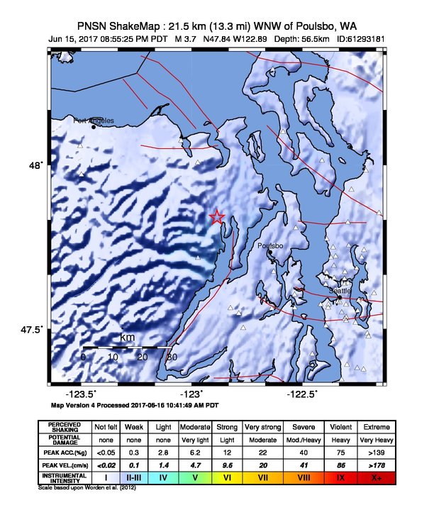
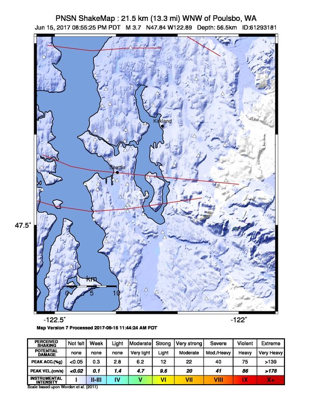
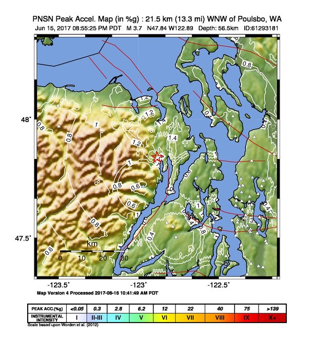
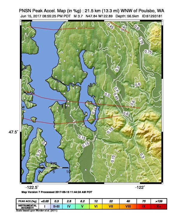
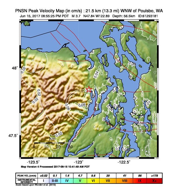
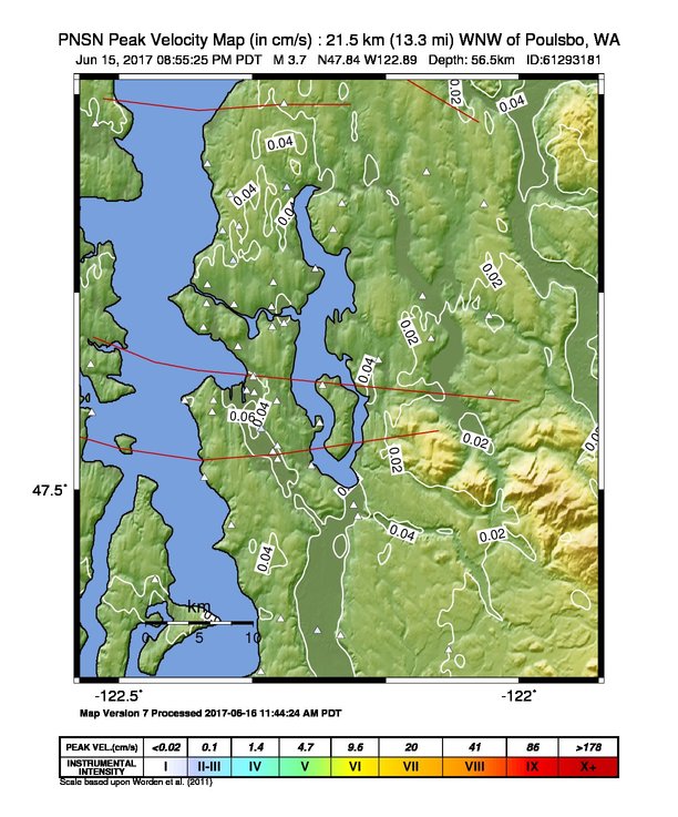
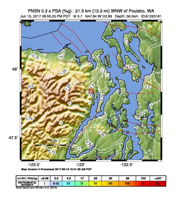
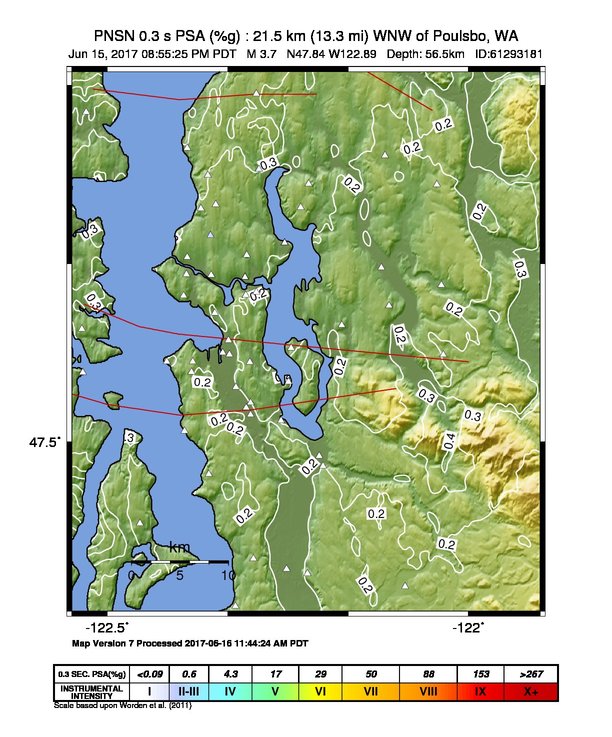
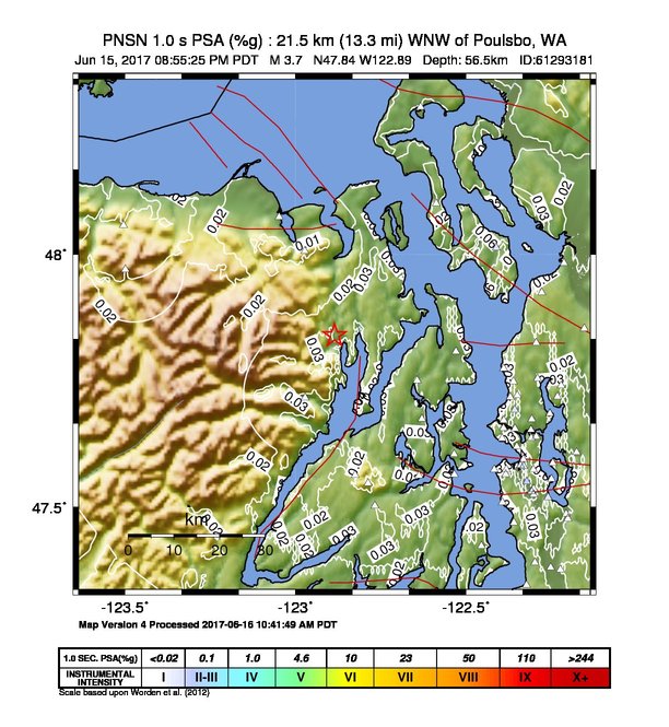
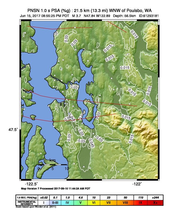
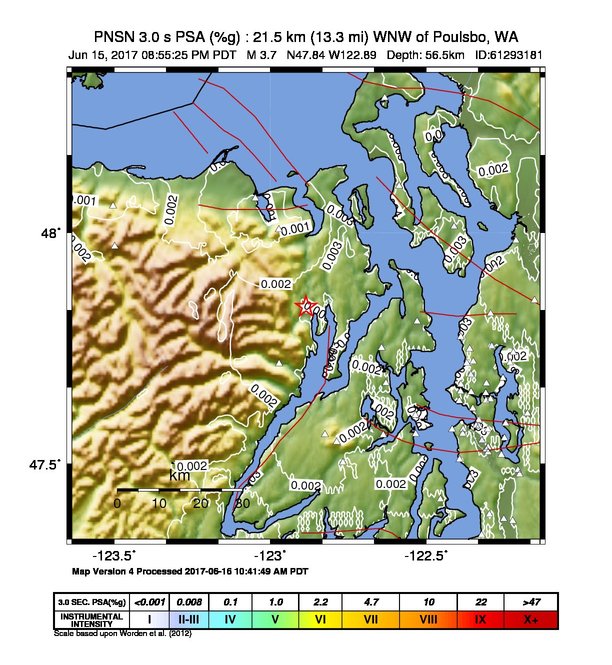
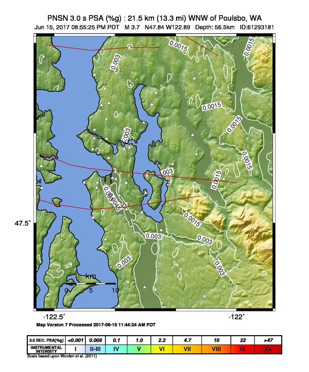
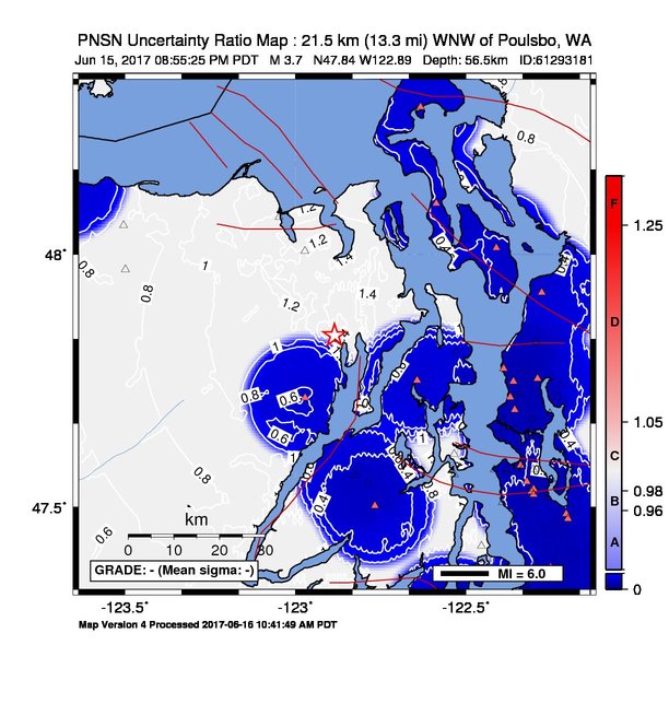
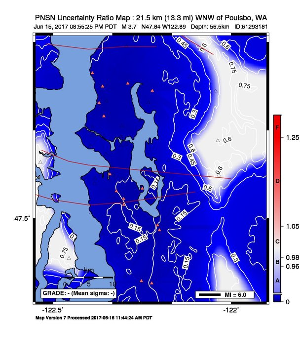
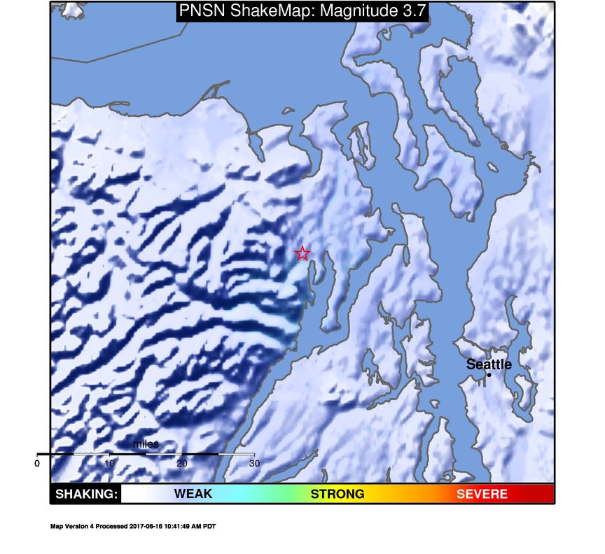
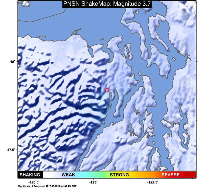
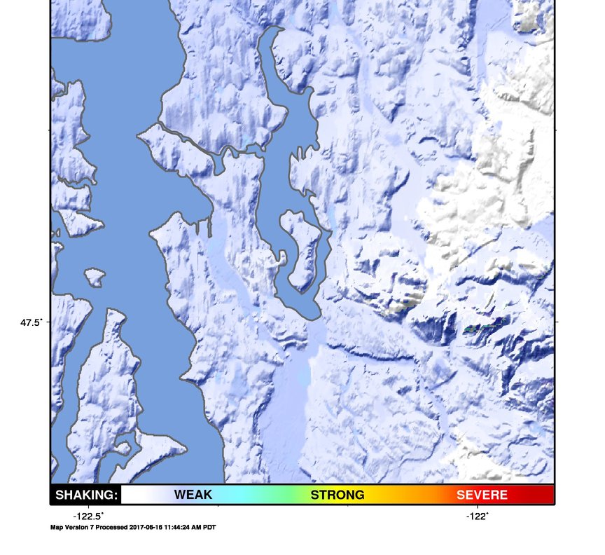
ShakeMap
Time:
Fri June 16, 2017 03:55:25 (UTC)
|
Depth:
54.88 km
|
Event ID:
61293181
|
Location:
47.839, -122.891


Downloads
| Regional | High Resolution Seattle | |
|---|---|---|
| intensity | JPG | PS.ZIP | JPG | PS.ZIP |
| acceleration | JPG | PS.ZIP | JPG | PS.ZIP |
| velocity | JPG | PS.ZIP | JPG | PS.ZIP |
| spectral 0.3 | JPG | PS.ZIP | JPG | PS.ZIP |
| spectral 1.0 | JPG | PS.ZIP | JPG | PS.ZIP |
| spectral 3.0 | JPG | PS.ZIP | JPG | PS.ZIP |
| uncertainty | JPG | PS.ZIP | JPG | PS.ZIP |
| tv map | JPG | PS.ZIP | JPG | PS.ZIP |
| tv map bare | JPG | PS.ZIP | JPG | PS.ZIP |
| tv info sheet | TXT | TXT |
| grid | XYZ.ZIP | XML.ZIP | XYZ.ZIP | XML.ZIP |
| gis | ZIP | ZIP |
| station | TXT | XML | TXT | XML |
| metadata | TXT | TXT |
Earthquake
| Event ID | Magnitude | Date | Time | Lat | Lon | Depth |
| 61293181 | 3.7 | // | :: | N47.84030 | W122.88570 | 56.45 km |
| Magnitude Bias: | MMI | PGA | PGV | PSA 0.3 | PSA 1.0 | PSA 3.0 |
| -0.55 | -1.11 | -0.61 | -1.38 | -0.87 | -0.39 |
Seismic Stations
| UW.ALKI: | Alki Wastewater Plant, Seattle, WA, USA | Agency: Pacific Northwest Seismic Network | |||
| Lat: 47.57510 Lon: -122.41760 Distance: 72.68 km from source | |||||
| Intensity: 1.0 | |||||
| Station Comp | Max Vel (cm/s) | Max Acc (%g) | PSA: 0.3 sec (%g) | 1.0 sec (%g) | 3.0 sec (%g) |
| --.HNN | 0.0084 | 0.0114 -T | 0.0290 -T | 0.0086 | 0.0016 |
| --.HNE | 0.0111 | 0.0112 -T | 0.0242 -T | 0.0175 | 0.0012 |
| UW.BABE: | Bainbridge School ANSS-SMO | Agency: Pacific Northwest Regional Seismic Network | |||
| Lat: 47.60583 Lon: -122.53528 Distance: 67.48 km from source | |||||
| Intensity: 1.7 | |||||
| Station Comp | Max Vel (cm/s) | Max Acc (%g) | PSA: 0.3 sec (%g) | 1.0 sec (%g) | 3.0 sec (%g) |
| --.ENN | 0.0366 | 0.0545 -T | 0.1480 | 0.0338 | 0.0021 |
| --.ENE | 0.0320 | 0.0750 -T | 0.1042 | 0.0292 | 0.0019 |
| UW.BEVT: | Boeing Everett ANSS-SMO | Agency: Pacific Northwest Regional Seismic Network | |||
| Lat: 47.92497 Lon: -122.27811 Distance: 72.99 km from source | |||||
| Intensity: 2.0 | |||||
| Station Comp | Max Vel (cm/s) | Max Acc (%g) | PSA: 0.3 sec (%g) | 1.0 sec (%g) | 3.0 sec (%g) |
| --.ENN | 0.0477 | 0.1281 | 0.2486 | 0.0136 | 0.0018 |
| --.ENE | 0.0280 | 0.0677 | 0.1082 | 0.0209 | 0.0015 |
| UW.BLN: | Blyn Mt. | Agency: Pacific Northwest Regional Seismic Network | |||
| Lat: 48.00662 Lon: -122.97265 Distance: 59.75 km from source | |||||
| Intensity: 1.5 | |||||
| Station Comp | Max Vel (cm/s) | Max Acc (%g) | PSA: 0.3 sec (%g) | 1.0 sec (%g) | 3.0 sec (%g) |
| --.ENN | 0.0193 | 0.0547 -T | 0.0762 | 0.0057 | 0.0004 |
| --.ENE | 0.0287 | 0.0819 -T | 0.1270 | 0.0070 | 0.0008 |
| UW.BNG: | Boeing Field King Co International | Agency: Pacific Northwest Seismic Network | |||
| Lat: 47.52547 Lon: -122.30166 Distance: 79.52 km from source | |||||
| Intensity: 1.5 | |||||
| Station Comp | Max Vel (cm/s) | Max Acc (%g) | PSA: 0.3 sec (%g) | 1.0 sec (%g) | 3.0 sec (%g) |
| --.HNN | 0.0282 | 0.0981 | 0.2335 | 0.0352 | 0.0020 |
| --.HNE | 0.0264 | 0.0641 | 0.1537 | 0.0261 | 0.0014 |
| UW.BRKS: | Brookside ANSS-SMO | Agency: Pacific Northwest Regional Seismic Network | |||
| Lat: 47.75520 Lon: -122.29013 Distance: 72.49 km from source | |||||
| Intensity: 2.4 | |||||
| Station Comp | Max Vel (cm/s) | Max Acc (%g) | PSA: 0.3 sec (%g) | 1.0 sec (%g) | 3.0 sec (%g) |
| --.ENN | 0.0789 | 0.2058 | 0.3400 | 0.0417 | 0.0041 |
| --.ENE | 0.0583 | 0.1058 | 0.2066 | 0.0302 | 0.0017 |
| UW.BSFP: | Boeing Fire Protection | Agency: Pacific Northwest Regional Seismic Network | |||
| Lat: 47.53186 Lon: -122.30777 Distance: 78.96 km from source | |||||
| Intensity: 2.0 | |||||
| Station Comp | Max Vel (cm/s) | Max Acc (%g) | PSA: 0.3 sec (%g) | 1.0 sec (%g) | 3.0 sec (%g) |
| --.ENN | 0.0500 | 0.0867 | 0.1956 | 0.0589 | 0.0042 |
| --.ENE | 0.0290 | 0.0585 | 0.2033 | 0.0420 | 0.0029 |
| UW.CTR: | Seattle Center | Agency: Pacific Northwest Seismic Network | |||
| Lat: 47.62070 Lon: -122.35140 Distance: 73.35 km from source | |||||
| Intensity: 1.1 | |||||
| Station Comp | Max Vel (cm/s) | Max Acc (%g) | PSA: 0.3 sec (%g) | 1.0 sec (%g) | 3.0 sec (%g) |
| --.HNN | 0.0188 | 0.0359 -T | 0.0647 -T | 0.0157 | 0.0016 |
| --.HNE | 0.0111 | 0.0241 -T | 0.0497 -T | 0.0074 | 0.0009 |
| UW.DOSE: | Dosewallips old TA.C04A, WA | Agency: Pacific Northwest Regional Seismic Network | |||
| Lat: 47.71720 Lon: -122.97180 Distance: 58.44 km from source | |||||
| Intensity: 2.6 | |||||
| Station Comp | Max Vel (cm/s) | Max Acc (%g) | PSA: 0.3 sec (%g) | 1.0 sec (%g) | 3.0 sec (%g) |
| --.BHE | 0.1118 | 0.4319 | 0.8442 | 0.0383 | 0.0026 |
| --.BHN | 0.0876 | 0.2939 | 0.6070 | 0.0236 | 0.0017 |
| UW.EVGW: | Everett Gateway Middle School ANSS-SMO | Agency: Pacific Northwest Regional Seismic Network | |||
| Lat: 47.85440 Lon: -122.15338 Distance: 78.58 km from source | |||||
| Intensity: 1.0 | |||||
| Station Comp | Max Vel (cm/s) | Max Acc (%g) | PSA: 0.3 sec (%g) | 1.0 sec (%g) | 3.0 sec (%g) |
| --.ENN | 0.0154 | 0.0261 -T | 0.0543 -T | 0.0143 | 0.0011 |
| --.ENE | 0.0125 | 0.0274 -T | 0.0611 -T | 0.0135 | 0.0010 |
| UW.FINN: | Finn Hill Jr High ANSS-SMO | Agency: Pacific Northwest Regional Seismic Network | |||
| Lat: 47.71950 Lon: -122.23220 Distance: 75.84 km from source | |||||
| Intensity: 1.1 | |||||
| Station Comp | Max Vel (cm/s) | Max Acc (%g) | PSA: 0.3 sec (%g) | 1.0 sec (%g) | 3.0 sec (%g) |
| --.ENN | 0.0166 | 0.0342 -T | 0.0455 -T | 0.0071 | 0.0008 |
| --.ENE | 0.0195 | 0.0214 -T | 0.0471 -T | 0.0091 | 0.0014 |
| UW.GMW: | Gold Mt. | Agency: Pacific Northwest Regional Seismic Network | |||
| Lat: 47.54773 Lon: -122.78759 Distance: 65.57 km from source | |||||
| Intensity: 1.1 | |||||
| Station Comp | Max Vel (cm/s) | Max Acc (%g) | PSA: 0.3 sec (%g) | 1.0 sec (%g) | 3.0 sec (%g) |
| --.ENN | 0.0197 | 0.0615 -T | 0.0802 | 0.0075 | 0.0008 |
| --.ENE | 0.0176 | 0.0418 -T | 0.0702 | 0.0193 | 0.0012 |
| UW.GNW: | Green Mountain (BB) CREST SMO | Agency: Pacific Northwest Regional Seismic Network | |||
| Lat: 47.56413 Lon: -122.82498 Distance: 64.42 km from source | |||||
| Intensity: 1.3 | |||||
| Station Comp | Max Vel (cm/s) | Max Acc (%g) | PSA: 0.3 sec (%g) | 1.0 sec (%g) | 3.0 sec (%g) |
| --.BHE | 0.0153 | 0.0610 | 0.0634 -T | 0.0091 | 0.0007 |
| --.BHN | 0.0224 | 0.1082 | 0.0613 -T | 0.0037 | 0.0005 |
| UW.GTWN: | Georgetown Playfield ANSS-SMO | Agency: Pacific Northwest Regional Seismic Network | |||
| Lat: 47.55121 Lon: -122.32201 Distance: 77.46 km from source | |||||
| Intensity: 2.5 | |||||
| Station Comp | Max Vel (cm/s) | Max Acc (%g) | PSA: 0.3 sec (%g) | 1.0 sec (%g) | 3.0 sec (%g) |
| --.ENN | 0.0963 | 0.1128 | 0.2344 | 0.1214 | 0.0053 |
| --.ENE | 0.0364 | 0.0670 | 0.1658 | 0.0293 | 0.0024 |
| UW.HICC: | Highline CC ANSS-SMO | Agency: Pacific Northwest Regional Seismic Network | |||
| Lat: 47.39012 Lon: -122.29790 Distance: 87.37 km from source | |||||
| Intensity: 1.0 | |||||
| Station Comp | Max Vel (cm/s) | Max Acc (%g) | PSA: 0.3 sec (%g) | 1.0 sec (%g) | 3.0 sec (%g) |
| --.ENN | 0.0147 | 0.0251 -T | 0.0502 -T | 0.0119 | 0.0017 |
| --.ENE | 0.0103 | 0.0230 -T | 0.0452 -T | 0.0051 | 0.0008 |
| UW.HOLY: | Holy Rosary ANSS-SMO | Agency: Pacific Northwest Regional Seismic Network | |||
| Lat: 47.56540 Lon: -122.38360 Distance: 74.38 km from source | |||||
| Intensity: 1.1 | |||||
| Station Comp | Max Vel (cm/s) | Max Acc (%g) | PSA: 0.3 sec (%g) | 1.0 sec (%g) | 3.0 sec (%g) |
| --.ENN | 0.0183 | 0.0258 -T | 0.0716 -T | 0.0199 | 0.0019 |
| --.ENE | 0.0190 | 0.0491 -T | 0.0697 -T | 0.0249 | 0.0015 |
| UW.HURR: | Hurricane Ridge, WA | Agency: Pacific Northwest Seismic Network | |||
| Lat: 47.97035 Lon: -123.49871 Distance: 74.05 km from source | |||||
| Intensity: 1.4 | |||||
| Station Comp | Max Vel (cm/s) | Max Acc (%g) | PSA: 0.3 sec (%g) | 1.0 sec (%g) | 3.0 sec (%g) |
| --.HNN | 0.0235 | 0.0656 -T | 0.1483 | 0.0146 | 0.0009 |
| --.HNE | 0.0268 | 0.0546 -T | 0.1879 | 0.0258 | 0.0019 |
| UW.KDK: | Coastal Environmental, Seattle ANSS-SMO | Agency: Pacific Northwest Regional Seismic Network | |||
| Lat: 47.59520 Lon: -122.33223 Distance: 75.12 km from source | |||||
| Intensity: 2.2 | |||||
| Station Comp | Max Vel (cm/s) | Max Acc (%g) | PSA: 0.3 sec (%g) | 1.0 sec (%g) | 3.0 sec (%g) |
| --.ENN | 0.0612 | 0.0777 -T | 0.2091 | 0.0399 | 0.0029 |
| --.ENE | 0.0331 | 0.0518 -T | 0.1045 | 0.0222 | 0.0015 |
| UW.KIMB: | Kimball School ANSS-SMO | Agency: Pacific Northwest Regional Seismic Network | |||
| Lat: 47.57480 Lon: -122.30280 Distance: 77.20 km from source | |||||
| Intensity: 1.5 | |||||
| Station Comp | Max Vel (cm/s) | Max Acc (%g) | PSA: 0.3 sec (%g) | 1.0 sec (%g) | 3.0 sec (%g) |
| --.ENN | 0.0283 | 0.0289 -T | 0.0699 | 0.0242 | 0.0025 |
| --.ENE | 0.0202 | 0.0304 -T | 0.0936 | 0.0192 | 0.0014 |
| UW.KIMR: | Kitsap Mod Risk ANSS-SMO | Agency: Pacific Northwest Regional Seismic Network | |||
| Lat: 47.50306 Lon: -122.76722 Distance: 68.35 km from source | |||||
| Intensity: 1.8 | |||||
| Station Comp | Max Vel (cm/s) | Max Acc (%g) | PSA: 0.3 sec (%g) | 1.0 sec (%g) | 3.0 sec (%g) |
| --.ENN | 0.0274 | 0.1022 | 0.0751 | 0.0151 | 0.0023 |
| --.ENE | 0.0395 | 0.1160 | 0.0816 | 0.0365 | 0.0021 |
| UW.KINR: | Kitsap Road Shed ANSS-SMO | Agency: Pacific Northwest Regional Seismic Network | |||
| Lat: 47.75167 Lon: -122.64306 Distance: 60.10 km from source | |||||
| Intensity: 2.4 | |||||
| Station Comp | Max Vel (cm/s) | Max Acc (%g) | PSA: 0.3 sec (%g) | 1.0 sec (%g) | 3.0 sec (%g) |
| --.ENN | 0.0312 | 0.1003 | 0.1487 | 0.0198 | 0.0015 |
| --.ENE | 0.0768 | 0.1584 | 0.2007 | 0.0327 | 0.0026 |
| UW.KITP: | Kitsap Treatment Plant ANSS-SMO | Agency: Pacific Northwest Regional Seismic Network | |||
| Lat: 47.67520 Lon: -122.62974 Distance: 62.37 km from source | |||||
| Intensity: 1.6 | |||||
| Station Comp | Max Vel (cm/s) | Max Acc (%g) | PSA: 0.3 sec (%g) | 1.0 sec (%g) | 3.0 sec (%g) |
| --.ENN | 0.0329 | 0.0518 -T | 0.1214 -T | 0.0283 | 0.0021 |
| --.ENE | 0.0318 | 0.0522 -T | 0.1240 -T | 0.0214 | 0.0015 |
| UW.KNEL: | Kent Elementary ANSS-SMO | Agency: Pacific Northwest Regional Seismic Network | |||
| Lat: 47.38052 Lon: -122.25193 Distance: 89.76 km from source | |||||
| Intensity: 2.4 | |||||
| Station Comp | Max Vel (cm/s) | Max Acc (%g) | PSA: 0.3 sec (%g) | 1.0 sec (%g) | 3.0 sec (%g) |
| --.ENN | 0.0740 | 0.1113 | 0.2573 | 0.0407 | 0.0037 |
| --.ENE | 0.0308 | 0.0842 | 0.1687 | 0.0287 | 0.0019 |
| UW.LAWT: | Lawton School ANSS-SMO | Agency: Pacific Northwest Regional Seismic Network | |||
| Lat: 47.65694 Lon: -122.39062 Distance: 70.52 km from source | |||||
| Intensity: 1.5 | |||||
| Station Comp | Max Vel (cm/s) | Max Acc (%g) | PSA: 0.3 sec (%g) | 1.0 sec (%g) | 3.0 sec (%g) |
| --.ENN | 0.0300 | 0.0652 -T | 0.2220 | 0.0226 | 0.0025 |
| --.ENE | 0.0207 | 0.0492 -T | 0.0868 | 0.0127 | 0.0011 |
| UW.LRIV: | Port Angeles, WA, USA | Agency: Pacific Northwest Regional Seismic Network | |||
| Lat: 48.05750 Lon: -123.50400 Distance: 76.75 km from source | |||||
| Intensity: 1.0 | |||||
| Station Comp | Max Vel (cm/s) | Max Acc (%g) | PSA: 0.3 sec (%g) | 1.0 sec (%g) | 3.0 sec (%g) |
| --.BHE | 0.0072 | 0.0290 -T | 0.0469 -T | 0.0043 | 0.0004 |
| --.BHN | 0.0075 | 0.0212 -T | 0.0434 -T | 0.0029 | 0.0004 |
| UW.LYNC: | Lynnwood City Hall, ANSS-SMO | Agency: Pacific Northwest Regional Seismic Network | |||
| Lat: 47.82555 Lon: -122.29384 Distance: 71.70 km from source | |||||
| Intensity: 1.1 | |||||
| Station Comp | Max Vel (cm/s) | Max Acc (%g) | PSA: 0.3 sec (%g) | 1.0 sec (%g) | 3.0 sec (%g) |
| --.ENN | 0.0179 | 0.0267 -T | 0.0464 -T | 0.0157 | 0.0011 |
| --.ENE | 0.0190 | 0.0416 -T | 0.0580 -T | 0.0182 | 0.0010 |
| UW.MNWA: | Manchester, WA | Agency: Pacific Northwest Regional Seismic Network | |||
| Lat: 47.56503 Lon: -122.53414 Distance: 69.39 km from source | |||||
| Intensity: 1.0 | |||||
| Station Comp | Max Vel (cm/s) | Max Acc (%g) | PSA: 0.3 sec (%g) | 1.0 sec (%g) | 3.0 sec (%g) |
| --.ENN | 0.0133 | 0.0257 -T | 0.0308 -T | 0.0085 | 0.0015 |
| --.ENE | 0.0070 | 0.0150 -T | 0.0267 -T | 0.0087 | 0.0008 |
| UW.MPL: | Maple Valley SMO | Agency: Pacific Northwest Regional Seismic Network | |||
| Lat: 47.68630 Lon: -122.25444 Distance: 75.54 km from source | |||||
| Intensity: 1.4 | |||||
| Station Comp | Max Vel (cm/s) | Max Acc (%g) | PSA: 0.3 sec (%g) | 1.0 sec (%g) | 3.0 sec (%g) |
| --.ENN | 0.0262 | 0.0361 -T | 0.0840 | 0.0263 | 0.0020 |
| --.ENE | 0.0167 | 0.0323 -T | 0.0989 | 0.0115 | 0.0009 |
| UW.NIHS: | Inglemoor HS ANSS-SMO | Agency: Pacific Northwest Regional Seismic Network | |||
| Lat: 47.74144 Lon: -122.22141 Distance: 75.96 km from source | |||||
| Intensity: 1.7 | |||||
| Station Comp | Max Vel (cm/s) | Max Acc (%g) | PSA: 0.3 sec (%g) | 1.0 sec (%g) | 3.0 sec (%g) |
| --.ENN | 0.0341 | 0.0857 -T | 0.1349 | 0.0183 | 0.0016 |
| --.ENE | 0.0296 | 0.0592 -T | 0.1057 | 0.0196 | 0.0018 |
| UW.NOWS: | NOAA, Seattle Bldg 3-SMO-IDS20 | Agency: Pacific Northwest Regional Seismic Network | |||
| Lat: 47.68630 Lon: -122.25444 Distance: 75.54 km from source | |||||
| Intensity: 1.4 | |||||
| Station Comp | Max Vel (cm/s) | Max Acc (%g) | PSA: 0.3 sec (%g) | 1.0 sec (%g) | 3.0 sec (%g) |
| --.ENN | 0.0212 | 0.0307 -T | 0.1076 | 0.0211 | 0.0018 |
| --.ENE | 0.0257 | 0.0514 -T | 0.1543 | 0.0102 | 0.0014 |
| UW.PIER: | Pier 30, Seattle, WA | Agency: Pacific Northwest Seismic Network | |||
| Lat: 47.58350 Lon: -122.34020 Distance: 75.28 km from source | |||||
| Intensity: 2.1 | |||||
| Station Comp | Max Vel (cm/s) | Max Acc (%g) | PSA: 0.3 sec (%g) | 1.0 sec (%g) | 3.0 sec (%g) |
| --.HNN | 0.0530 | 0.1100 | 0.2032 | 0.0620 | 0.0038 |
| --.HNE | 0.0281 | 0.0868 | 0.1579 | 0.0404 | 0.0025 |
| UW.PSNS: | Puget Sound Naval Shipyard - ANSS SMO | Agency: Pacific Northwest Regional Seismic Network | |||
| Lat: 47.56273 Lon: -122.63763 Distance: 66.96 km from source | |||||
| Intensity: 1.5 | |||||
| Station Comp | Max Vel (cm/s) | Max Acc (%g) | PSA: 0.3 sec (%g) | 1.0 sec (%g) | 3.0 sec (%g) |
| --.ENN | 0.0248 | 0.0526 -T | 0.0647 | 0.0205 | 0.0018 |
| --.ENE | 0.0290 | 0.0433 -T | 0.1095 | 0.0220 | 0.0021 |
| UW.QADA: | NW 61st St, Ballard, WA | Agency: Pacific Northwest Regional Seismic Network | |||
| Lat: 47.67280 Lon: -122.38963 Distance: 70.06 km from source | |||||
| Intensity: 1.4 | |||||
| Station Comp | Max Vel (cm/s) | Max Acc (%g) | PSA: 0.3 sec (%g) | 1.0 sec (%g) | 3.0 sec (%g) |
| 01.HNN | 0.0264 | 0.0560 -T | 0.1199 | 0.0174 | 0.0021 |
| 01.HNE | 0.0186 | 0.0452 -T | 0.0663 | 0.0122 | 0.0021 |
| 01.HNZ | 0.0153 | 0.0613 -T | 0.0462 | 0.0100 | 0.0014 |
| UW.QARB: | UW Arboretum, Seattle, WA | Agency: Pacific Northwest Regional Seismic Network | |||
| Lat: 47.64031 Lon: -122.29381 Distance: 75.10 km from source | |||||
| Intensity: 1.5 | |||||
| Station Comp | Max Vel (cm/s) | Max Acc (%g) | PSA: 0.3 sec (%g) | 1.0 sec (%g) | 3.0 sec (%g) |
| 01.HNN | 0.0296 | 0.0552 -T | 0.1045 | 0.0295 | 0.0026 |
| 01.HNE | 0.0188 | 0.0406 -T | 0.0728 | 0.0232 | 0.0016 |
| 01.HNZ | 0.0224 | 0.0998 -T | 0.0511 | 0.0127 | 0.0034 |
| UW.QBIT: | Bitter Lake, Seattle, WA | Agency: Pacific Northwest Regional Seismic Network | |||
| Lat: 47.72215 Lon: -122.34992 Distance: 70.44 km from source | |||||
| Intensity: 2.0 | |||||
| Station Comp | Max Vel (cm/s) | Max Acc (%g) | PSA: 0.3 sec (%g) | 1.0 sec (%g) | 3.0 sec (%g) |
| 01.HNN | 0.0504 | 0.0622 -T | 0.1615 | 0.0279 | 0.0024 |
| 01.HNE | 0.0180 | 0.0530 -T | 0.1118 | 0.0127 | 0.0013 |
| 01.HNZ | 0.0507 | 0.1773 -T | 0.0973 | 0.0093 | 0.0014 |
| UW.QBOG: | Palatine Ave W, Seattle, WA | Agency: Pacific Northwest Regional Seismic Network | |||
| Lat: 47.69325 Lon: -122.35712 Distance: 70.81 km from source | |||||
| Intensity: 2.5 | |||||
| Station Comp | Max Vel (cm/s) | Max Acc (%g) | PSA: 0.3 sec (%g) | 1.0 sec (%g) | 3.0 sec (%g) |
| 01.HNN | 0.0830 | 0.1628 | 0.5028 | 0.0568 | 0.0043 |
| 01.HNE | 0.0864 | 0.1443 | 0.5725 | 0.0319 | 0.0040 |
| 01.HNZ | 0.0220 | 0.1068 | 0.1490 | 0.0153 | 0.0019 |
| UW.QCDG: | Bakken Rd. Greenback, WA | Agency: Pacific Northwest Regional Seismic Network | |||
| Lat: 48.10002 Lon: -122.58696 Distance: 67.20 km from source | |||||
| Intensity: 1.8 | |||||
| Station Comp | Max Vel (cm/s) | Max Acc (%g) | PSA: 0.3 sec (%g) | 1.0 sec (%g) | 3.0 sec (%g) |
| 01.HNN | 0.0394 | 0.1172 | 0.3143 | 0.0176 | 0.0029 |
| 01.HNE | 0.0385 | 0.1121 | 0.2109 | 0.0127 | 0.0026 |
| 01.HNZ | 0.0301 | 0.1143 | 0.0948 | 0.0169 | 0.0014 |
| UW.QEGA: | Grand Ave, Everett, WA | Agency: Pacific Northwest Regional Seismic Network | |||
| Lat: 47.98284 Lon: -122.21261 Distance: 77.17 km from source | |||||
| Intensity: 1.0 | |||||
| Station Comp | Max Vel (cm/s) | Max Acc (%g) | PSA: 0.3 sec (%g) | 1.0 sec (%g) | 3.0 sec (%g) |
| 01.HNN | 0.0100 | 0.0309 -T | 0.0363 -T | 0.0101 | 0.0023 |
| 01.HNE | 0.0105 | 0.0323 -T | 0.0348 -T | 0.0102 | 0.0022 |
| 01.HNZ | 0.0191 | 0.0975 -T | 0.0532 -T | 0.0068 | 0.0014 |
| UW.QEMI: | 19th Av E. Seattle, WA | Agency: Pacific Northwest Regional Seismic Network | |||
| Lat: 47.63748 Lon: -122.30854 Distance: 74.55 km from source | |||||
| Intensity: 1.7 | |||||
| Station Comp | Max Vel (cm/s) | Max Acc (%g) | PSA: 0.3 sec (%g) | 1.0 sec (%g) | 3.0 sec (%g) |
| 01.HNN | 0.0341 | 0.0779 -T | 0.0954 | 0.0284 | 0.0025 |
| 01.HNE | 0.0229 | 0.0668 -T | 0.0866 | 0.0186 | 0.0017 |
| 01.HNZ | 0.0308 | 0.1677 -T | 0.0452 | 0.0098 | 0.0015 |
| UW.QHAN: | 39th Avenue SW, Seattle, WA | Agency: Pacific Northwest Regional Seismic Network | |||
| Lat: 47.57523 Lon: -122.38187 Distance: 74.00 km from source | |||||
| Intensity: 1.0 | |||||
| Station Comp | Max Vel (cm/s) | Max Acc (%g) | PSA: 0.3 sec (%g) | 1.0 sec (%g) | 3.0 sec (%g) |
| 01.HNN | 0.0123 | 0.0284 -T | 0.0391 -T | 0.0161 | 0.0031 |
| 01.HNE | 0.0150 | 0.0409 -T | 0.0520 -T | 0.0215 | 0.0020 |
| 01.HNZ | 0.0117 | 0.0391 -T | 0.0392 -T | 0.0094 | 0.0012 |
| UW.QHRH: | Cedar Ave, Renton, WA | Agency: Pacific Northwest Regional Seismic Network | |||
| Lat: 47.47731 Lon: -122.20142 Distance: 86.27 km from source | |||||
| Intensity: 1.6 | |||||
| Station Comp | Max Vel (cm/s) | Max Acc (%g) | PSA: 0.3 sec (%g) | 1.0 sec (%g) | 3.0 sec (%g) |
| 01.HNN | 0.0318 | 0.0634 | 0.0840 | 0.0309 | 0.0021 |
| 01.HNE | 0.0129 | 0.0443 | 0.0579 | 0.0095 | 0.0023 |
| 01.HNZ | 0.0077 | 0.0391 | 0.0349 | 0.0070 | 0.0021 |
| UW.QJEA: | E. Chicago St., Kent, WA | Agency: Pacific Northwest Regional Seismic Network | |||
| Lat: 47.37622 Lon: -122.22317 Distance: 91.19 km from source | |||||
| Intensity: 1.6 | |||||
| Station Comp | Max Vel (cm/s) | Max Acc (%g) | PSA: 0.3 sec (%g) | 1.0 sec (%g) | 3.0 sec (%g) |
| 01.HNN | 0.0309 | 0.0553 | 0.1403 | 0.0145 | 0.0017 |
| 01.HNE | 0.0120 | 0.0417 | 0.0950 | 0.0107 | 0.0023 |
| 01.HNZ | 0.0109 | 0.0502 | 0.0541 | 0.0054 | 0.0025 |
| UW.QKTN: | Trabant Residence, Kingston, WA | Agency: Pacific Northwest Regional Seismic Network | |||
| Lat: 47.80860 Lon: -122.52930 Distance: 62.51 km from source | |||||
| Intensity: 1.4 | |||||
| Station Comp | Max Vel (cm/s) | Max Acc (%g) | PSA: 0.3 sec (%g) | 1.0 sec (%g) | 3.0 sec (%g) |
| 01.HNN | 0.0176 | 0.0521 -T | 0.0707 -T | 0.0150 | 0.0016 |
| 01.HNE | 0.0251 | 0.0562 -T | 0.0840 -T | 0.0202 | 0.0024 |
| 01.HNZ | 0.0224 | 0.0974 -T | 0.0883 -T | 0.0119 | 0.0012 |
| UW.QLBR: | SW 149th St, Burien, WA | Agency: Pacific Northwest Regional Seismic Network | |||
| Lat: 47.46955 Lon: -122.35948 Distance: 80.25 km from source | |||||
| Intensity: 1.1 | |||||
| Station Comp | Max Vel (cm/s) | Max Acc (%g) | PSA: 0.3 sec (%g) | 1.0 sec (%g) | 3.0 sec (%g) |
| 01.HNN | 0.0197 | 0.0380 -T | 0.0773 | 0.0228 | 0.0037 |
| 01.HNE | 0.0196 | 0.0319 -T | 0.0543 | 0.0097 | 0.0021 |
| 01.HNZ | 0.0115 | 0.0515 -T | 0.0356 | 0.0121 | 0.0014 |
| UW.QMAC: | 11th Ave S., Federal Way, WA | Agency: Pacific Northwest Regional Seismic Network | |||
| Lat: 47.34549 Lon: -122.32254 Distance: 89.43 km from source | |||||
| Intensity: 1.0 | |||||
| Station Comp | Max Vel (cm/s) | Max Acc (%g) | PSA: 0.3 sec (%g) | 1.0 sec (%g) | 3.0 sec (%g) |
| 01.HNN | 0.0135 | 0.0315 -T | 0.0493 -T | 0.0104 | 0.0019 |
| 01.HNE | 0.0076 | 0.0250 -T | 0.0426 -T | 0.0081 | 0.0019 |
| 01.HNZ | 0.0077 | 0.0332 -T | 0.0275 -T | 0.0057 | 0.0016 |
| UW.QMAL: | Malone, Seattle, WA | Agency: Pacific Northwest Regional Seismic Network | |||
| Lat: 47.67500 Lon: -122.30704 Distance: 73.45 km from source | |||||
| Intensity: 1.5 | |||||
| Station Comp | Max Vel (cm/s) | Max Acc (%g) | PSA: 0.3 sec (%g) | 1.0 sec (%g) | 3.0 sec (%g) |
| 01.HNN | 0.0291 | 0.0672 -T | 0.1855 | 0.0251 | 0.0024 |
| 01.HNE | 0.0239 | 0.0641 -T | 0.1134 | 0.0138 | 0.0023 |
| 01.HNZ | 0.0395 | 0.1591 -T | 0.0994 | 0.0113 | 0.0016 |
| UW.QMIN: | 70th Ave SE, Mercer Island, WA | Agency: Pacific Northwest Regional Seismic Network | |||
| Lat: 47.58788 Lon: -122.24559 Distance: 79.17 km from source | |||||
| Intensity: 1.2 | |||||
| Station Comp | Max Vel (cm/s) | Max Acc (%g) | PSA: 0.3 sec (%g) | 1.0 sec (%g) | 3.0 sec (%g) |
| 01.HNN | 0.0193 | 0.0285 -T | 0.0627 | 0.0239 | 0.0022 |
| 01.HNE | 0.0208 | 0.0316 -T | 0.1046 | 0.0216 | 0.0023 |
| 01.HNZ | 0.0179 | 0.0191 -T | 0.0495 | 0.0179 | 0.0018 |
| UW.QNKP: | 11th Ave NW, Seattle, WA | Agency: Pacific Northwest Regional Seismic Network | |||
| Lat: 47.71848 Lon: -122.37050 Distance: 69.66 km from source | |||||
| Intensity: 2.2 | |||||
| Station Comp | Max Vel (cm/s) | Max Acc (%g) | PSA: 0.3 sec (%g) | 1.0 sec (%g) | 3.0 sec (%g) |
| 01.HNN | 0.0620 | 0.1504 | 0.2160 | 0.0390 | 0.0032 |
| 01.HNE | 0.0361 | 0.1382 | 0.1510 | 0.0160 | 0.0023 |
| 01.HNZ | 0.0282 | 0.1013 | 0.0874 | 0.0074 | 0.0015 |
| UW.QNWT: | W Newton St, Seattle, WA | Agency: Pacific Northwest Regional Seismic Network | |||
| Lat: 47.63694 Lon: -122.39440 Distance: 71.05 km from source | |||||
| Intensity: 1.1 | |||||
| Station Comp | Max Vel (cm/s) | Max Acc (%g) | PSA: 0.3 sec (%g) | 1.0 sec (%g) | 3.0 sec (%g) |
| 01.HNN | 0.0191 | 0.0339 -T | 0.1127 | 0.0198 | 0.0029 |
| 01.HNE | 0.0139 | 0.0322 -T | 0.0585 | 0.0144 | 0.0021 |
| 01.HNZ | 0.0106 | 0.0993 -T | 0.0558 | 0.0106 | 0.0016 |
| UW.QOUT: | Maplewood Pl, Seattle, WA | Agency: Pacific Northwest Regional Seismic Network | |||
| Lat: 47.51009 Lon: -122.39303 Distance: 76.78 km from source | |||||
| Intensity: 2.0 | |||||
| Station Comp | Max Vel (cm/s) | Max Acc (%g) | PSA: 0.3 sec (%g) | 1.0 sec (%g) | 3.0 sec (%g) |
| 01.HNN | 0.0489 | 0.0657 -T | 0.1297 | 0.0326 | 0.0030 |
| 01.HNE | 0.0263 | 0.0727 -T | 0.1396 | 0.0271 | 0.0025 |
| 01.HNZ | 0.0173 | 0.0473 -T | 0.0663 | 0.0098 | 0.0019 |
| UW.QPAL: | Fremont, Seattle, WA | Agency: Pacific Northwest Regional Seismic Network | |||
| Lat: 47.65630 Lon: -122.35632 Distance: 71.91 km from source | |||||
| Intensity: 1.1 | |||||
| Station Comp | Max Vel (cm/s) | Max Acc (%g) | PSA: 0.3 sec (%g) | 1.0 sec (%g) | 3.0 sec (%g) |
| 01.HNN | 0.0196 | 0.0377 -T | 0.0890 | 0.0186 | 0.0023 |
| 01.HNE | 0.0164 | 0.0505 -T | 0.1125 | 0.0102 | 0.0017 |
| 01.HNZ | 0.0179 | 0.1040 -T | 0.0649 | 0.0108 | 0.0016 |
| UW.QRCR: | Burnett Ave N, Renton, WA | Agency: Pacific Northwest Regional Seismic Network | |||
| Lat: 47.48674 Lon: -122.20673 Distance: 85.54 km from source | |||||
| Intensity: 1.9 | |||||
| Station Comp | Max Vel (cm/s) | Max Acc (%g) | PSA: 0.3 sec (%g) | 1.0 sec (%g) | 3.0 sec (%g) |
| 01.HNN | 0.0442 | 0.0825 | 0.2493 | 0.0365 | 0.0034 |
| 01.HNE | 0.0343 | 0.0800 | 0.2019 | 0.0337 | 0.0023 |
| 01.HNZ | 0.0247 | 0.0483 | 0.0712 | 0.0166 | 0.0022 |
| UW.QRMB: | NW 201st Place, Shoreline, WA | Agency: Pacific Northwest Regional Seismic Network | |||
| Lat: 47.77483 Lon: -122.38951 Distance: 67.92 km from source | |||||
| Intensity: 2.1 | |||||
| Station Comp | Max Vel (cm/s) | Max Acc (%g) | PSA: 0.3 sec (%g) | 1.0 sec (%g) | 3.0 sec (%g) |
| 01.HNN | 0.0568 | 0.1731 | 0.2527 | 0.0301 | 0.0028 |
| 01.HNE | 0.0416 | 0.1144 | 0.1508 | 0.0214 | 0.0020 |
| 01.HNZ | 0.0393 | 0.1813 | 0.0917 | 0.0103 | 0.0013 |
| UW.QRNR: | Rainier S, Seattle, WA | Agency: Pacific Northwest Regional Seismic Network | |||
| Lat: 47.51982 Lon: -122.25959 Distance: 81.57 km from source | |||||
| Intensity: 1.7 | |||||
| Station Comp | Max Vel (cm/s) | Max Acc (%g) | PSA: 0.3 sec (%g) | 1.0 sec (%g) | 3.0 sec (%g) |
| 01.HNN | 0.0350 | 0.0318 -T | 0.0762 | 0.0564 | 0.0023 |
| 01.HNE | 0.0199 | 0.0279 -T | 0.0814 | 0.0259 | 0.0025 |
| 01.HNZ | 0.0172 | 0.0247 -T | 0.0377 | 0.0201 | 0.0017 |
| UW.QSRV: | PNSN Server Room, Seattle, WA | Agency: Pacific Northwest Regional Seismic Network | |||
| Lat: 47.65424 Lon: -122.30938 Distance: 73.97 km from source | |||||
| Intensity: 1.0 | |||||
| Station Comp | Max Vel (cm/s) | Max Acc (%g) | PSA: 0.3 sec (%g) | 1.0 sec (%g) | 3.0 sec (%g) |
| 01.HNN | 0.0145 | 0.0335 -T | 0.0495 -T | 0.0211 | 0.0020 |
| 01.HNE | 0.0105 | 0.0312 -T | 0.0314 -T | 0.0156 | 0.0025 |
| 01.HNZ | 0.0098 | 0.0871 -T | 0.0488 -T | 0.0097 | 0.0016 |
| UW.SCC: | Shoreline CC ANSS-SMO | Agency: Pacific Northwest Regional Seismic Network | |||
| Lat: 47.74965 Lon: -122.36105 Distance: 69.46 km from source | |||||
| Intensity: 2.1 | |||||
| Station Comp | Max Vel (cm/s) | Max Acc (%g) | PSA: 0.3 sec (%g) | 1.0 sec (%g) | 3.0 sec (%g) |
| --.ENN | 0.0556 | 0.1619 | 0.3214 | 0.0261 | 0.0027 |
| --.ENE | 0.0286 | 0.0780 | 0.1612 | 0.0220 | 0.0010 |
| UW.SEA: | Seattle (Wood Anderson SMO) | Agency: Pacific Northwest Regional Seismic Network | |||
| Lat: 47.65421 Lon: -122.30938 Distance: 73.97 km from source | |||||
| Intensity: NaN | |||||
| Station Comp | Max Vel (cm/s) | Max Acc (%g) | PSA: 0.3 sec (%g) | 1.0 sec (%g) | 3.0 sec (%g) |
| --.ENN | 0.0007 -G | 0.0014 -G | 0.0007 -G | 0.0003 -G | 0.0001 -G |
| --.ENE | 0.0104 | 0.0238 | 0.0366 | 0.0084 | 0.0005 |
| UW.SP2: | Seward Park, Seattle SMO-IDS24 BB(7/97) | Agency: Pacific Northwest Regional Seismic Network | |||
| Lat: 47.55629 Lon: -122.24923 Distance: 80.33 km from source | |||||
| Intensity: 1.9 | |||||
| Station Comp | Max Vel (cm/s) | Max Acc (%g) | PSA: 0.3 sec (%g) | 1.0 sec (%g) | 3.0 sec (%g) |
| --.BHE | 0.0013 | 0.0018 -T | 0.0036 | 0.0009 | 0.0001 |
| --.BHN | 0.0414 | 0.0637 -T | 0.2255 | 0.0359 | 0.0025 |
| UW.SQM: | PNNL - Sequim, WA, USA | Agency: Pacific Northwest Seismic Network | |||
| Lat: 48.07368 Lon: -123.04806 Distance: 63.29 km from source | |||||
| Intensity: 1.2 | |||||
| Station Comp | Max Vel (cm/s) | Max Acc (%g) | PSA: 0.3 sec (%g) | 1.0 sec (%g) | 3.0 sec (%g) |
| --.ENN | 0.0168 | 0.0569 -T | 0.1342 | 0.0093 | 0.0007 |
| --.ENE | 0.0206 | 0.0435 -T | 0.0772 | 0.0092 | 0.0008 |
| UW.SSS2: | John Stanford Center surface, Seattle, ANSS-SMO | Agency: Pacific Northwest Regional Seismic Network | |||
| Lat: 47.58180 Lon: -122.33109 Distance: 75.73 km from source | |||||
| Intensity: 2.0 | |||||
| Station Comp | Max Vel (cm/s) | Max Acc (%g) | PSA: 0.3 sec (%g) | 1.0 sec (%g) | 3.0 sec (%g) |
| --.ENN | 0.0472 | 0.0821 -T | 0.1793 | 0.0525 | 0.0033 |
| --.ENE | 0.0315 | 0.0730 -T | 0.1808 | 0.0295 | 0.0021 |
| UW.SVOH: | Skagit Valley CC ANSS-SMO | Agency: Pacific Northwest Regional Seismic Network | |||
| Lat: 48.28920 Lon: -122.63316 Distance: 77.66 km from source | |||||
| Intensity: 2.3 | |||||
| Station Comp | Max Vel (cm/s) | Max Acc (%g) | PSA: 0.3 sec (%g) | 1.0 sec (%g) | 3.0 sec (%g) |
| --.ENN | 0.0661 | 0.1499 | 0.2988 | 0.0349 | 0.0023 |
| --.ENE | 0.0736 | 0.1332 | 0.2466 | 0.0340 | 0.0025 |
| UW.SWID: | South Whidbey SD ANSS-SMO | Agency: Pacific Northwest Regional Seismic Network | |||
| Lat: 48.01285 Lon: -122.41101 Distance: 69.32 km from source | |||||
| Intensity: 2.1 | |||||
| Station Comp | Max Vel (cm/s) | Max Acc (%g) | PSA: 0.3 sec (%g) | 1.0 sec (%g) | 3.0 sec (%g) |
| --.ENN | 0.0554 | 0.1232 | 0.1423 | 0.0593 | 0.0037 |
| --.ENE | 0.0294 | 0.0610 | 0.1004 | 0.0249 | 0.0015 |
| UW.TKCO: | King Co EOC - SMO | Agency: Pacific Northwest Regional Seismic Network | |||
| Lat: 47.53668 Lon: -122.30165 Distance: 78.98 km from source | |||||
| Intensity: 1.6 | |||||
| Station Comp | Max Vel (cm/s) | Max Acc (%g) | PSA: 0.3 sec (%g) | 1.0 sec (%g) | 3.0 sec (%g) |
| --.ENN | 0.0319 | 0.0790 | 0.1332 | 0.0236 | 0.0018 |
| --.ENE | 0.0286 | 0.0609 | 0.2212 | 0.0270 | 0.0020 |
| UW.VVHS: | Vashon HS ANSS-SMO | Agency: Pacific Northwest Regional Seismic Network | |||
| Lat: 47.42345 Lon: -122.45488 Distance: 79.86 km from source | |||||
| Intensity: 1.0 | |||||
| Station Comp | Max Vel (cm/s) | Max Acc (%g) | PSA: 0.3 sec (%g) | 1.0 sec (%g) | 3.0 sec (%g) |
| --.ENN | 0.0136 | 0.0358 -T | 0.0217 -T | 0.0126 | 0.0008 |
| --.ENE | 0.0095 | 0.0247 -T | 0.0292 -T | 0.0114 | 0.0010 |
| UW.WISC: | Wilburton Center ANSS-SMO | Agency: Pacific Northwest Regional Seismic Network | |||
| Lat: 47.60926 Lon: -122.17553 Distance: 81.66 km from source | |||||
| Intensity: 1.0 | |||||
| Station Comp | Max Vel (cm/s) | Max Acc (%g) | PSA: 0.3 sec (%g) | 1.0 sec (%g) | 3.0 sec (%g) |
| --.ENN | 0.0167 | 0.0370 -T | 0.0519 -T | 0.0131 | 0.0016 |
| --.ENE | 0.0099 | 0.0303 -T | 0.0470 -T | 0.0079 | 0.0006 |
Earthquake
| Event ID | Magnitude | Date | Time | Lat | Lon | Depth |
| 61293181 | 3.7 | // | :: | N47.84030 | W122.88570 | 56.45 km |
| Magnitude Bias: | MMI | PGA | PGV | PSA 0.3 | PSA 1.0 | PSA 3.0 |
| -0.54 | -1.11 | -0.59 | -1.38 | -0.82 | -0.37 |
Seismic Stations
| UW.ALCT: | Alcott School, Redmond ANSS-SMO | Agency: Pacific Northwest Regional Seismic Network | |||
| Lat: 47.64690 Lon: -122.03770 Distance: 87.58 km from epicenter | |||||
| Intensity: 1.0 | |||||
| Station Comp | Max Vel (cm/s) | Max Acc (%g) | PSA: 0.3 sec (%g) | 1.0 sec (%g) | 3.0 sec (%g) |
| --.ENN | 0.0152 | 0.0384 -T | 0.0441 | 0.0181 | 0.0010 |
| --.ENE | 0.0175 | 0.0493 -T | 0.0760 | 0.0086 | 0.0010 |
| UW.ALKI: | Alki Wastewater Plant, Seattle, WA, USA | Agency: Pacific Northwest Seismic Network | |||
| Lat: 47.57510 Lon: -122.41760 Distance: 72.68 km from epicenter | |||||
| Intensity: 1.0 | |||||
| Station Comp | Max Vel (cm/s) | Max Acc (%g) | PSA: 0.3 sec (%g) | 1.0 sec (%g) | 3.0 sec (%g) |
| --.HNN | 0.0084 | 0.0114 -T | 0.0290 -T | 0.0086 | 0.0016 |
| --.HNE | 0.0111 | 0.0112 -T | 0.0242 -T | 0.0175 | 0.0012 |
| UW.BABE: | Bainbridge School ANSS-SMO | Agency: Pacific Northwest Regional Seismic Network | |||
| Lat: 47.60583 Lon: -122.53528 Distance: 67.48 km from epicenter | |||||
| Intensity: 1.7 | |||||
| Station Comp | Max Vel (cm/s) | Max Acc (%g) | PSA: 0.3 sec (%g) | 1.0 sec (%g) | 3.0 sec (%g) |
| --.ENN | 0.0366 | 0.0545 -T | 0.1480 | 0.0338 | 0.0021 |
| --.ENE | 0.0320 | 0.0750 -T | 0.1042 | 0.0292 | 0.0019 |
| UW.BNG: | Boeing Field King Co International | Agency: Pacific Northwest Seismic Network | |||
| Lat: 47.52547 Lon: -122.30166 Distance: 79.52 km from epicenter | |||||
| Intensity: 1.5 | |||||
| Station Comp | Max Vel (cm/s) | Max Acc (%g) | PSA: 0.3 sec (%g) | 1.0 sec (%g) | 3.0 sec (%g) |
| --.HNN | 0.0282 | 0.0981 | 0.2335 | 0.0352 | 0.0020 |
| --.HNE | 0.0264 | 0.0641 | 0.1537 | 0.0261 | 0.0014 |
| UW.BRKS: | Brookside ANSS-SMO | Agency: Pacific Northwest Regional Seismic Network | |||
| Lat: 47.75520 Lon: -122.29013 Distance: 72.49 km from epicenter | |||||
| Intensity: 2.4 | |||||
| Station Comp | Max Vel (cm/s) | Max Acc (%g) | PSA: 0.3 sec (%g) | 1.0 sec (%g) | 3.0 sec (%g) |
| --.ENN | 0.0789 | 0.2058 | 0.3400 | 0.0417 | 0.0041 |
| --.ENE | 0.0583 | 0.1058 | 0.2066 | 0.0302 | 0.0017 |
| UW.BSFP: | Boeing Fire Protection | Agency: Pacific Northwest Regional Seismic Network | |||
| Lat: 47.53186 Lon: -122.30777 Distance: 78.96 km from epicenter | |||||
| Intensity: 2.0 | |||||
| Station Comp | Max Vel (cm/s) | Max Acc (%g) | PSA: 0.3 sec (%g) | 1.0 sec (%g) | 3.0 sec (%g) |
| --.ENN | 0.0500 | 0.0867 -T | 0.1956 | 0.0589 | 0.0042 |
| --.ENE | 0.0290 | 0.0585 -T | 0.2033 | 0.0420 | 0.0029 |
| UW.CTR: | Seattle Center | Agency: Pacific Northwest Seismic Network | |||
| Lat: 47.62070 Lon: -122.35140 Distance: 73.35 km from epicenter | |||||
| Intensity: 1.1 | |||||
| Station Comp | Max Vel (cm/s) | Max Acc (%g) | PSA: 0.3 sec (%g) | 1.0 sec (%g) | 3.0 sec (%g) |
| --.HNN | 0.0188 | 0.0359 -T | 0.0647 -T | 0.0157 | 0.0016 |
| --.HNE | 0.0111 | 0.0241 -T | 0.0497 -T | 0.0074 | 0.0009 |
| UW.EARN: | East Ridge ES ANSS-SMO | Agency: Pacific Northwest Regional Seismic Network | |||
| Lat: 47.74090 Lon: -122.04380 Distance: 85.23 km from epicenter | |||||
| Intensity: 1.3 | |||||
| Station Comp | Max Vel (cm/s) | Max Acc (%g) | PSA: 0.3 sec (%g) | 1.0 sec (%g) | 3.0 sec (%g) |
| --.ENN | 0.0204 | 0.0541 -T | 0.0693 | 0.0111 | 0.0011 |
| --.ENE | 0.0228 | 0.0537 -T | 0.0817 | 0.0162 | 0.0013 |
| UW.FINN: | Finn Hill Jr High ANSS-SMO | Agency: Pacific Northwest Regional Seismic Network | |||
| Lat: 47.71950 Lon: -122.23220 Distance: 75.84 km from epicenter | |||||
| Intensity: 1.1 | |||||
| Station Comp | Max Vel (cm/s) | Max Acc (%g) | PSA: 0.3 sec (%g) | 1.0 sec (%g) | 3.0 sec (%g) |
| --.ENN | 0.0166 | 0.0342 -T | 0.0455 -T | 0.0071 | 0.0008 |
| --.ENE | 0.0195 | 0.0214 -T | 0.0471 -T | 0.0091 | 0.0014 |
| UW.GTWN: | Georgetown Playfield ANSS-SMO | Agency: Pacific Northwest Regional Seismic Network | |||
| Lat: 47.55121 Lon: -122.32201 Distance: 77.46 km from epicenter | |||||
| Intensity: 2.5 | |||||
| Station Comp | Max Vel (cm/s) | Max Acc (%g) | PSA: 0.3 sec (%g) | 1.0 sec (%g) | 3.0 sec (%g) |
| --.ENN | 0.0963 | 0.1128 | 0.2344 | 0.1214 | 0.0053 |
| --.ENE | 0.0364 | 0.0670 | 0.1658 | 0.0293 | 0.0024 |
| UW.HICC: | Highline CC ANSS-SMO | Agency: Pacific Northwest Regional Seismic Network | |||
| Lat: 47.39012 Lon: -122.29790 Distance: 87.37 km from epicenter | |||||
| Intensity: 1.0 | |||||
| Station Comp | Max Vel (cm/s) | Max Acc (%g) | PSA: 0.3 sec (%g) | 1.0 sec (%g) | 3.0 sec (%g) |
| --.ENN | 0.0147 | 0.0251 -T | 0.0502 | 0.0119 | 0.0017 |
| --.ENE | 0.0103 | 0.0230 -T | 0.0452 | 0.0051 | 0.0008 |
| UW.HOLY: | Holy Rosary ANSS-SMO | Agency: Pacific Northwest Regional Seismic Network | |||
| Lat: 47.56540 Lon: -122.38360 Distance: 74.38 km from epicenter | |||||
| Intensity: 1.1 | |||||
| Station Comp | Max Vel (cm/s) | Max Acc (%g) | PSA: 0.3 sec (%g) | 1.0 sec (%g) | 3.0 sec (%g) |
| --.ENN | 0.0183 | 0.0258 -T | 0.0716 -T | 0.0199 | 0.0019 |
| --.ENE | 0.0190 | 0.0491 -T | 0.0697 -T | 0.0249 | 0.0015 |
| UW.KDK: | Coastal Environmental, Seattle ANSS-SMO | Agency: Pacific Northwest Regional Seismic Network | |||
| Lat: 47.59520 Lon: -122.33223 Distance: 75.12 km from epicenter | |||||
| Intensity: 2.2 | |||||
| Station Comp | Max Vel (cm/s) | Max Acc (%g) | PSA: 0.3 sec (%g) | 1.0 sec (%g) | 3.0 sec (%g) |
| --.ENN | 0.0612 | 0.0777 -T | 0.2091 | 0.0399 | 0.0029 |
| --.ENE | 0.0331 | 0.0518 -T | 0.1045 | 0.0222 | 0.0015 |
| UW.KIMB: | Kimball School ANSS-SMO | Agency: Pacific Northwest Regional Seismic Network | |||
| Lat: 47.57480 Lon: -122.30280 Distance: 77.20 km from epicenter | |||||
| Intensity: 1.5 | |||||
| Station Comp | Max Vel (cm/s) | Max Acc (%g) | PSA: 0.3 sec (%g) | 1.0 sec (%g) | 3.0 sec (%g) |
| --.ENN | 0.0283 | 0.0289 -T | 0.0699 | 0.0242 | 0.0025 |
| --.ENE | 0.0202 | 0.0304 -T | 0.0936 | 0.0192 | 0.0014 |
| UW.KNEL: | Kent Elementary ANSS-SMO | Agency: Pacific Northwest Regional Seismic Network | |||
| Lat: 47.38052 Lon: -122.25193 Distance: 89.76 km from epicenter | |||||
| Intensity: 2.4 | |||||
| Station Comp | Max Vel (cm/s) | Max Acc (%g) | PSA: 0.3 sec (%g) | 1.0 sec (%g) | 3.0 sec (%g) |
| --.ENN | 0.0740 | 0.1113 | 0.2573 | 0.0407 | 0.0037 |
| --.ENE | 0.0308 | 0.0842 | 0.1687 | 0.0287 | 0.0019 |
| UW.LAWT: | Lawton School ANSS-SMO | Agency: Pacific Northwest Regional Seismic Network | |||
| Lat: 47.65694 Lon: -122.39062 Distance: 70.52 km from epicenter | |||||
| Intensity: 1.5 | |||||
| Station Comp | Max Vel (cm/s) | Max Acc (%g) | PSA: 0.3 sec (%g) | 1.0 sec (%g) | 3.0 sec (%g) |
| --.ENN | 0.0300 | 0.0652 -T | 0.2220 | 0.0226 | 0.0025 |
| --.ENE | 0.0207 | 0.0492 -T | 0.0868 | 0.0127 | 0.0011 |
| UW.LEOT: | Leota J. High ANSS-SMO | Agency: Pacific Northwest Regional Seismic Network | |||
| Lat: 47.76790 Lon: -122.11560 Distance: 80.99 km from epicenter | |||||
| Intensity: 1.6 | |||||
| Station Comp | Max Vel (cm/s) | Max Acc (%g) | PSA: 0.3 sec (%g) | 1.0 sec (%g) | 3.0 sec (%g) |
| --.ENN | 0.0251 | 0.0545 -T | 0.1134 | 0.0142 | 0.0017 |
| --.ENE | 0.0333 | 0.0491 -T | 0.1171 | 0.0149 | 0.0018 |
| UW.LYNC: | Lynnwood City Hall, ANSS-SMO | Agency: Pacific Northwest Regional Seismic Network | |||
| Lat: 47.82555 Lon: -122.29384 Distance: 71.70 km from epicenter | |||||
| Intensity: 1.1 | |||||
| Station Comp | Max Vel (cm/s) | Max Acc (%g) | PSA: 0.3 sec (%g) | 1.0 sec (%g) | 3.0 sec (%g) |
| --.ENN | 0.0179 | 0.0267 -T | 0.0464 -T | 0.0157 | 0.0011 |
| --.ENE | 0.0190 | 0.0416 -T | 0.0580 -T | 0.0182 | 0.0010 |
| UW.MARY: | Marymoor Park ANSS-SMO | Agency: Pacific Northwest Regional Seismic Network | |||
| Lat: 47.66334 Lon: -122.12068 Distance: 82.73 km from epicenter | |||||
| Intensity: 1.1 | |||||
| Station Comp | Max Vel (cm/s) | Max Acc (%g) | PSA: 0.3 sec (%g) | 1.0 sec (%g) | 3.0 sec (%g) |
| --.ENN | 0.0135 | 0.0265 -T | 0.0488 | 0.0129 | 0.0011 |
| --.ENE | 0.0180 | 0.0402 -T | 0.0586 | 0.0118 | 0.0013 |
| UW.MNWA: | Manchester, WA | Agency: Pacific Northwest Regional Seismic Network | |||
| Lat: 47.56503 Lon: -122.53414 Distance: 69.39 km from epicenter | |||||
| Intensity: 1.0 | |||||
| Station Comp | Max Vel (cm/s) | Max Acc (%g) | PSA: 0.3 sec (%g) | 1.0 sec (%g) | 3.0 sec (%g) |
| --.ENN | 0.0133 | 0.0257 -T | 0.0308 -T | 0.0085 | 0.0015 |
| --.ENE | 0.0070 | 0.0150 -T | 0.0267 -T | 0.0087 | 0.0008 |
| UW.MPL: | Maple Valley SMO | Agency: Pacific Northwest Regional Seismic Network | |||
| Lat: 47.68630 Lon: -122.25444 Distance: 75.54 km from epicenter | |||||
| Intensity: 1.4 | |||||
| Station Comp | Max Vel (cm/s) | Max Acc (%g) | PSA: 0.3 sec (%g) | 1.0 sec (%g) | 3.0 sec (%g) |
| --.ENN | 0.0262 | 0.0361 -T | 0.0840 | 0.0263 | 0.0020 |
| --.ENE | 0.0167 | 0.0323 -T | 0.0989 | 0.0115 | 0.0009 |
| UW.NIHS: | Inglemoor HS ANSS-SMO | Agency: Pacific Northwest Regional Seismic Network | |||
| Lat: 47.74144 Lon: -122.22141 Distance: 75.96 km from epicenter | |||||
| Intensity: 1.7 | |||||
| Station Comp | Max Vel (cm/s) | Max Acc (%g) | PSA: 0.3 sec (%g) | 1.0 sec (%g) | 3.0 sec (%g) |
| --.ENN | 0.0341 | 0.0857 | 0.1349 | 0.0183 | 0.0016 |
| --.ENE | 0.0296 | 0.0592 | 0.1057 | 0.0196 | 0.0018 |
| UW.NOWS: | NOAA, Seattle Bldg 3-SMO-IDS20 | Agency: Pacific Northwest Regional Seismic Network | |||
| Lat: 47.68630 Lon: -122.25444 Distance: 75.54 km from epicenter | |||||
| Intensity: 1.4 | |||||
| Station Comp | Max Vel (cm/s) | Max Acc (%g) | PSA: 0.3 sec (%g) | 1.0 sec (%g) | 3.0 sec (%g) |
| --.ENN | 0.0212 | 0.0307 -T | 0.1076 | 0.0211 | 0.0018 |
| --.ENE | 0.0257 | 0.0514 -T | 0.1543 | 0.0102 | 0.0014 |
| UW.PIER: | Pier 30, Seattle, WA | Agency: Pacific Northwest Seismic Network | |||
| Lat: 47.58350 Lon: -122.34020 Distance: 75.28 km from epicenter | |||||
| Intensity: 2.1 | |||||
| Station Comp | Max Vel (cm/s) | Max Acc (%g) | PSA: 0.3 sec (%g) | 1.0 sec (%g) | 3.0 sec (%g) |
| --.HNN | 0.0530 | 0.1100 | 0.2032 | 0.0620 | 0.0038 |
| --.HNE | 0.0281 | 0.0868 | 0.1579 | 0.0404 | 0.0025 |
| UW.PNLK: | Pine Lake JH ANSS-SMO | Agency: Pacific Northwest Seismic Network | |||
| Lat: 47.58162 Lon: -122.03483 Distance: 89.82 km from epicenter | |||||
| Intensity: 1.0 | |||||
| Station Comp | Max Vel (cm/s) | Max Acc (%g) | PSA: 0.3 sec (%g) | 1.0 sec (%g) | 3.0 sec (%g) |
| --.HNN | 0.0128 | 0.0325 -T | 0.0409 -T | 0.0105 | 0.0008 |
| --.HNE | 0.0077 | 0.0209 -T | 0.0265 -T | 0.0052 | 0.0004 |
| UW.QADA: | NW 61st St, Ballard, WA | Agency: Pacific Northwest Regional Seismic Network | |||
| Lat: 47.67280 Lon: -122.38963 Distance: 70.06 km from epicenter | |||||
| Intensity: 1.4 | |||||
| Station Comp | Max Vel (cm/s) | Max Acc (%g) | PSA: 0.3 sec (%g) | 1.0 sec (%g) | 3.0 sec (%g) |
| 01.HNN | 0.0264 | 0.0560 -T | 0.1199 | 0.0174 | 0.0021 |
| 01.HNE | 0.0186 | 0.0452 -T | 0.0663 | 0.0122 | 0.0021 |
| 01.HNZ | 0.0153 | 0.0613 -T | 0.0462 | 0.0100 | 0.0014 |
| UW.QARB: | UW Arboretum, Seattle, WA | Agency: Pacific Northwest Regional Seismic Network | |||
| Lat: 47.64031 Lon: -122.29381 Distance: 75.10 km from epicenter | |||||
| Intensity: 1.5 | |||||
| Station Comp | Max Vel (cm/s) | Max Acc (%g) | PSA: 0.3 sec (%g) | 1.0 sec (%g) | 3.0 sec (%g) |
| 01.HNN | 0.0296 | 0.0552 -T | 0.1045 | 0.0295 | 0.0026 |
| 01.HNE | 0.0188 | 0.0406 -T | 0.0728 | 0.0232 | 0.0016 |
| 01.HNZ | 0.0224 | 0.0998 -T | 0.0511 | 0.0127 | 0.0034 |
| UW.QBIT: | Bitter Lake, Seattle, WA | Agency: Pacific Northwest Regional Seismic Network | |||
| Lat: 47.72215 Lon: -122.34992 Distance: 70.44 km from epicenter | |||||
| Intensity: 2.0 | |||||
| Station Comp | Max Vel (cm/s) | Max Acc (%g) | PSA: 0.3 sec (%g) | 1.0 sec (%g) | 3.0 sec (%g) |
| 01.HNN | 0.0504 | 0.0622 -T | 0.1615 | 0.0279 | 0.0024 |
| 01.HNE | 0.0180 | 0.0530 -T | 0.1118 | 0.0127 | 0.0013 |
| 01.HNZ | 0.0507 | 0.1773 -T | 0.0973 | 0.0093 | 0.0014 |
| UW.QBOG: | Palatine Ave W, Seattle, WA | Agency: Pacific Northwest Regional Seismic Network | |||
| Lat: 47.69325 Lon: -122.35712 Distance: 70.81 km from epicenter | |||||
| Intensity: 2.5 | |||||
| Station Comp | Max Vel (cm/s) | Max Acc (%g) | PSA: 0.3 sec (%g) | 1.0 sec (%g) | 3.0 sec (%g) |
| 01.HNN | 0.0830 | 0.1628 | 0.5028 | 0.0568 | 0.0043 |
| 01.HNE | 0.0864 | 0.1443 | 0.5725 | 0.0319 | 0.0040 |
| 01.HNZ | 0.0220 | 0.1068 | 0.1490 | 0.0153 | 0.0019 |
| UW.QEMI: | 19th Av E. Seattle, WA | Agency: Pacific Northwest Regional Seismic Network | |||
| Lat: 47.63748 Lon: -122.30854 Distance: 74.55 km from epicenter | |||||
| Intensity: 1.7 | |||||
| Station Comp | Max Vel (cm/s) | Max Acc (%g) | PSA: 0.3 sec (%g) | 1.0 sec (%g) | 3.0 sec (%g) |
| 01.HNN | 0.0341 | 0.0779 -T | 0.0954 | 0.0284 | 0.0025 |
| 01.HNE | 0.0229 | 0.0668 -T | 0.0866 | 0.0186 | 0.0017 |
| 01.HNZ | 0.0308 | 0.1677 -T | 0.0452 | 0.0098 | 0.0015 |
| UW.QESB: | 172 Pl. NE, Bellevue, WA | Agency: Pacific Northwest Regional Seismic Network | |||
| Lat: 47.62750 Lon: -122.11012 Distance: 84.33 km from epicenter | |||||
| Intensity: 1.0 | |||||
| Station Comp | Max Vel (cm/s) | Max Acc (%g) | PSA: 0.3 sec (%g) | 1.0 sec (%g) | 3.0 sec (%g) |
| 01.HNN | 0.0173 | 0.0379 -T | 0.0788 | 0.0137 | 0.0035 |
| 01.HNE | 0.0141 | 0.0258 -T | 0.0520 | 0.0113 | 0.0019 |
| 01.HNZ | 0.0082 | 0.0210 -T | 0.0461 | 0.0082 | 0.0027 |
| UW.QHAN: | 39th Avenue SW, Seattle, WA | Agency: Pacific Northwest Regional Seismic Network | |||
| Lat: 47.57523 Lon: -122.38187 Distance: 74.00 km from epicenter | |||||
| Intensity: 1.0 | |||||
| Station Comp | Max Vel (cm/s) | Max Acc (%g) | PSA: 0.3 sec (%g) | 1.0 sec (%g) | 3.0 sec (%g) |
| 01.HNN | 0.0123 | 0.0284 -T | 0.0391 -T | 0.0161 | 0.0031 |
| 01.HNE | 0.0150 | 0.0409 -T | 0.0520 -T | 0.0215 | 0.0020 |
| 01.HNZ | 0.0117 | 0.0391 -T | 0.0392 -T | 0.0094 | 0.0012 |
| UW.QHRH: | Cedar Ave, Renton, WA | Agency: Pacific Northwest Regional Seismic Network | |||
| Lat: 47.47731 Lon: -122.20142 Distance: 86.27 km from epicenter | |||||
| Intensity: 1.6 | |||||
| Station Comp | Max Vel (cm/s) | Max Acc (%g) | PSA: 0.3 sec (%g) | 1.0 sec (%g) | 3.0 sec (%g) |
| 01.HNN | 0.0318 | 0.0634 | 0.0840 | 0.0309 | 0.0021 |
| 01.HNE | 0.0129 | 0.0443 | 0.0579 | 0.0095 | 0.0023 |
| 01.HNZ | 0.0077 | 0.0391 | 0.0349 | 0.0070 | 0.0021 |
| UW.QJEA: | E. Chicago St., Kent, WA | Agency: Pacific Northwest Regional Seismic Network | |||
| Lat: 47.37622 Lon: -122.22317 Distance: 91.19 km from epicenter | |||||
| Intensity: 1.6 | |||||
| Station Comp | Max Vel (cm/s) | Max Acc (%g) | PSA: 0.3 sec (%g) | 1.0 sec (%g) | 3.0 sec (%g) |
| 01.HNN | 0.0309 | 0.0553 | 0.1403 | 0.0145 | 0.0017 |
| 01.HNE | 0.0120 | 0.0417 | 0.0950 | 0.0107 | 0.0023 |
| 01.HNZ | 0.0109 | 0.0502 | 0.0541 | 0.0054 | 0.0025 |
| UW.QKTN: | Trabant Residence, Kingston, WA | Agency: Pacific Northwest Regional Seismic Network | |||
| Lat: 47.80860 Lon: -122.52930 Distance: 62.51 km from epicenter | |||||
| Intensity: 1.4 | |||||
| Station Comp | Max Vel (cm/s) | Max Acc (%g) | PSA: 0.3 sec (%g) | 1.0 sec (%g) | 3.0 sec (%g) |
| 01.HNN | 0.0176 | 0.0521 -T | 0.0707 -T | 0.0150 | 0.0016 |
| 01.HNE | 0.0251 | 0.0562 -T | 0.0840 -T | 0.0202 | 0.0024 |
| 01.HNZ | 0.0224 | 0.0974 -T | 0.0883 -T | 0.0119 | 0.0012 |
| UW.QLBR: | SW 149th St, Burien, WA | Agency: Pacific Northwest Regional Seismic Network | |||
| Lat: 47.46955 Lon: -122.35948 Distance: 80.25 km from epicenter | |||||
| Intensity: 1.1 | |||||
| Station Comp | Max Vel (cm/s) | Max Acc (%g) | PSA: 0.3 sec (%g) | 1.0 sec (%g) | 3.0 sec (%g) |
| 01.HNN | 0.0197 | 0.0380 -T | 0.0773 | 0.0228 | 0.0037 |
| 01.HNE | 0.0196 | 0.0319 -T | 0.0543 | 0.0097 | 0.0021 |
| 01.HNZ | 0.0115 | 0.0515 -T | 0.0356 | 0.0121 | 0.0014 |
| UW.QMAC: | 11th Ave S., Federal Way, WA | Agency: Pacific Northwest Regional Seismic Network | |||
| Lat: 47.34549 Lon: -122.32254 Distance: 89.43 km from epicenter | |||||
| Intensity: 1.0 | |||||
| Station Comp | Max Vel (cm/s) | Max Acc (%g) | PSA: 0.3 sec (%g) | 1.0 sec (%g) | 3.0 sec (%g) |
| 01.HNN | 0.0135 | 0.0315 -T | 0.0493 | 0.0104 | 0.0019 |
| 01.HNE | 0.0076 | 0.0250 -T | 0.0426 | 0.0081 | 0.0019 |
| 01.HNZ | 0.0077 | 0.0332 -T | 0.0275 | 0.0057 | 0.0016 |
| UW.QMAL: | Malone, Seattle, WA | Agency: Pacific Northwest Regional Seismic Network | |||
| Lat: 47.67500 Lon: -122.30704 Distance: 73.45 km from epicenter | |||||
| Intensity: 1.5 | |||||
| Station Comp | Max Vel (cm/s) | Max Acc (%g) | PSA: 0.3 sec (%g) | 1.0 sec (%g) | 3.0 sec (%g) |
| 01.HNN | 0.0291 | 0.0672 -T | 0.1855 | 0.0251 | 0.0024 |
| 01.HNE | 0.0239 | 0.0641 -T | 0.1134 | 0.0138 | 0.0023 |
| 01.HNZ | 0.0395 | 0.1591 -T | 0.0994 | 0.0113 | 0.0016 |
| UW.QMIN: | 70th Ave SE, Mercer Island, WA | Agency: Pacific Northwest Regional Seismic Network | |||
| Lat: 47.58788 Lon: -122.24559 Distance: 79.17 km from epicenter | |||||
| Intensity: 1.2 | |||||
| Station Comp | Max Vel (cm/s) | Max Acc (%g) | PSA: 0.3 sec (%g) | 1.0 sec (%g) | 3.0 sec (%g) |
| 01.HNN | 0.0193 | 0.0285 -T | 0.0627 | 0.0239 | 0.0022 |
| 01.HNE | 0.0208 | 0.0316 -T | 0.1046 | 0.0216 | 0.0023 |
| 01.HNZ | 0.0179 | 0.0191 -T | 0.0495 | 0.0179 | 0.0018 |
| UW.QMLO: | SE 265th St. Covington, WA | Agency: Pacific Northwest Regional Seismic Network | |||
| Lat: 47.36405 Lon: -122.08769 Distance: 97.83 km from epicenter | |||||
| Intensity: 1.0 | |||||
| Station Comp | Max Vel (cm/s) | Max Acc (%g) | PSA: 0.3 sec (%g) | 1.0 sec (%g) | 3.0 sec (%g) |
| 01.HNN | 0.0173 | 0.0473 -T | 0.0663 | 0.0132 | 0.0016 |
| 01.HNE | 0.0120 | 0.0246 -T | 0.0808 | 0.0138 | 0.0027 |
| 01.HNZ | 0.0076 | 0.0189 -T | 0.0330 | 0.0094 | 0.0015 |
| UW.QNKP: | 11th Ave NW, Seattle, WA | Agency: Pacific Northwest Regional Seismic Network | |||
| Lat: 47.71848 Lon: -122.37050 Distance: 69.66 km from epicenter | |||||
| Intensity: 2.2 | |||||
| Station Comp | Max Vel (cm/s) | Max Acc (%g) | PSA: 0.3 sec (%g) | 1.0 sec (%g) | 3.0 sec (%g) |
| 01.HNN | 0.0620 | 0.1504 | 0.2160 | 0.0390 | 0.0032 |
| 01.HNE | 0.0361 | 0.1382 | 0.1510 | 0.0160 | 0.0023 |
| 01.HNZ | 0.0282 | 0.1013 | 0.0874 | 0.0074 | 0.0015 |
| UW.QNWT: | W Newton St, Seattle, WA | Agency: Pacific Northwest Regional Seismic Network | |||
| Lat: 47.63694 Lon: -122.39440 Distance: 71.05 km from epicenter | |||||
| Intensity: 1.1 | |||||
| Station Comp | Max Vel (cm/s) | Max Acc (%g) | PSA: 0.3 sec (%g) | 1.0 sec (%g) | 3.0 sec (%g) |
| 01.HNN | 0.0191 | 0.0339 -T | 0.1127 | 0.0198 | 0.0029 |
| 01.HNE | 0.0139 | 0.0322 -T | 0.0585 | 0.0144 | 0.0021 |
| 01.HNZ | 0.0106 | 0.0993 -T | 0.0558 | 0.0106 | 0.0016 |
| UW.QOUT: | Maplewood Pl, Seattle, WA | Agency: Pacific Northwest Regional Seismic Network | |||
| Lat: 47.51009 Lon: -122.39303 Distance: 76.78 km from epicenter | |||||
| Intensity: 2.0 | |||||
| Station Comp | Max Vel (cm/s) | Max Acc (%g) | PSA: 0.3 sec (%g) | 1.0 sec (%g) | 3.0 sec (%g) |
| 01.HNN | 0.0489 | 0.0657 -T | 0.1297 | 0.0326 | 0.0030 |
| 01.HNE | 0.0263 | 0.0727 -T | 0.1396 | 0.0271 | 0.0025 |
| 01.HNZ | 0.0173 | 0.0473 -T | 0.0663 | 0.0098 | 0.0019 |
| UW.QPAL: | Fremont, Seattle, WA | Agency: Pacific Northwest Regional Seismic Network | |||
| Lat: 47.65630 Lon: -122.35632 Distance: 71.91 km from epicenter | |||||
| Intensity: 1.1 | |||||
| Station Comp | Max Vel (cm/s) | Max Acc (%g) | PSA: 0.3 sec (%g) | 1.0 sec (%g) | 3.0 sec (%g) |
| 01.HNN | 0.0196 | 0.0377 -T | 0.0890 | 0.0186 | 0.0023 |
| 01.HNE | 0.0164 | 0.0505 -T | 0.1125 | 0.0102 | 0.0017 |
| 01.HNZ | 0.0179 | 0.1040 -T | 0.0649 | 0.0108 | 0.0016 |
| UW.QRCR: | Burnett Ave N, Renton, WA | Agency: Pacific Northwest Regional Seismic Network | |||
| Lat: 47.48674 Lon: -122.20673 Distance: 85.54 km from epicenter | |||||
| Intensity: 1.9 | |||||
| Station Comp | Max Vel (cm/s) | Max Acc (%g) | PSA: 0.3 sec (%g) | 1.0 sec (%g) | 3.0 sec (%g) |
| 01.HNN | 0.0442 | 0.0825 | 0.2493 | 0.0365 | 0.0034 |
| 01.HNE | 0.0343 | 0.0800 | 0.2019 | 0.0337 | 0.0023 |
| 01.HNZ | 0.0247 | 0.0483 | 0.0712 | 0.0166 | 0.0022 |
| UW.QRMB: | NW 201st Place, Shoreline, WA | Agency: Pacific Northwest Regional Seismic Network | |||
| Lat: 47.77483 Lon: -122.38951 Distance: 67.92 km from epicenter | |||||
| Intensity: 2.1 | |||||
| Station Comp | Max Vel (cm/s) | Max Acc (%g) | PSA: 0.3 sec (%g) | 1.0 sec (%g) | 3.0 sec (%g) |
| 01.HNN | 0.0568 | 0.1731 | 0.2527 | 0.0301 | 0.0028 |
| 01.HNE | 0.0416 | 0.1144 | 0.1508 | 0.0214 | 0.0020 |
| 01.HNZ | 0.0393 | 0.1813 | 0.0917 | 0.0103 | 0.0013 |
| UW.QRNR: | Rainier S, Seattle, WA | Agency: Pacific Northwest Regional Seismic Network | |||
| Lat: 47.51982 Lon: -122.25959 Distance: 81.57 km from epicenter | |||||
| Intensity: 1.7 | |||||
| Station Comp | Max Vel (cm/s) | Max Acc (%g) | PSA: 0.3 sec (%g) | 1.0 sec (%g) | 3.0 sec (%g) |
| 01.HNN | 0.0350 | 0.0318 -T | 0.0762 | 0.0564 | 0.0023 |
| 01.HNE | 0.0199 | 0.0279 -T | 0.0814 | 0.0259 | 0.0025 |
| 01.HNZ | 0.0172 | 0.0247 -T | 0.0377 | 0.0201 | 0.0017 |
| UW.QSRV: | PNSN Server Room, Seattle, WA | Agency: Pacific Northwest Regional Seismic Network | |||
| Lat: 47.65424 Lon: -122.30938 Distance: 73.97 km from epicenter | |||||
| Intensity: 1.0 | |||||
| Station Comp | Max Vel (cm/s) | Max Acc (%g) | PSA: 0.3 sec (%g) | 1.0 sec (%g) | 3.0 sec (%g) |
| 01.HNN | 0.0145 | 0.0335 -T | 0.0495 -T | 0.0211 | 0.0020 |
| 01.HNE | 0.0105 | 0.0312 -T | 0.0314 -T | 0.0156 | 0.0025 |
| 01.HNZ | 0.0098 | 0.0871 -T | 0.0488 -T | 0.0097 | 0.0016 |
| UW.SCC: | Shoreline CC ANSS-SMO | Agency: Pacific Northwest Regional Seismic Network | |||
| Lat: 47.74965 Lon: -122.36105 Distance: 69.46 km from epicenter | |||||
| Intensity: 2.1 | |||||
| Station Comp | Max Vel (cm/s) | Max Acc (%g) | PSA: 0.3 sec (%g) | 1.0 sec (%g) | 3.0 sec (%g) |
| --.ENN | 0.0556 | 0.1619 | 0.3214 | 0.0261 | 0.0027 |
| --.ENE | 0.0286 | 0.0780 | 0.1612 | 0.0220 | 0.0010 |
| UW.SEA: | Seattle (Wood Anderson SMO) | Agency: Pacific Northwest Regional Seismic Network | |||
| Lat: 47.65421 Lon: -122.30938 Distance: 73.97 km from epicenter | |||||
| Intensity: NaN | |||||
| Station Comp | Max Vel (cm/s) | Max Acc (%g) | PSA: 0.3 sec (%g) | 1.0 sec (%g) | 3.0 sec (%g) |
| --.ENN | 0.0007 -G | 0.0014 -G | 0.0007 -G | 0.0003 -G | 0.0001 -G |
| --.ENE | 0.0104 | 0.0238 | 0.0366 | 0.0084 | 0.0005 |
| UW.SP2: | Seward Park, Seattle SMO-IDS24 BB(7/97) | Agency: Pacific Northwest Regional Seismic Network | |||
| Lat: 47.55629 Lon: -122.24923 Distance: 80.33 km from epicenter | |||||
| Intensity: 1.9 | |||||
| Station Comp | Max Vel (cm/s) | Max Acc (%g) | PSA: 0.3 sec (%g) | 1.0 sec (%g) | 3.0 sec (%g) |
| --.BHE | 0.0013 | 0.0018 | 0.0036 | 0.0009 | 0.0001 |
| --.BHN | 0.0414 | 0.0637 | 0.2255 | 0.0359 | 0.0025 |
| UW.SSS2: | John Stanford Center surface, Seattle, ANSS-SMO | Agency: Pacific Northwest Regional Seismic Network | |||
| Lat: 47.58180 Lon: -122.33109 Distance: 75.73 km from epicenter | |||||
| Intensity: 2.0 | |||||
| Station Comp | Max Vel (cm/s) | Max Acc (%g) | PSA: 0.3 sec (%g) | 1.0 sec (%g) | 3.0 sec (%g) |
| --.ENN | 0.0472 | 0.0821 -T | 0.1793 | 0.0525 | 0.0033 |
| --.ENE | 0.0315 | 0.0730 -T | 0.1808 | 0.0295 | 0.0021 |
| UW.TKCO: | King Co EOC - SMO | Agency: Pacific Northwest Regional Seismic Network | |||
| Lat: 47.53668 Lon: -122.30165 Distance: 78.98 km from epicenter | |||||
| Intensity: 1.6 | |||||
| Station Comp | Max Vel (cm/s) | Max Acc (%g) | PSA: 0.3 sec (%g) | 1.0 sec (%g) | 3.0 sec (%g) |
| --.ENN | 0.0319 | 0.0790 | 0.1332 | 0.0236 | 0.0018 |
| --.ENE | 0.0286 | 0.0609 | 0.2212 | 0.0270 | 0.0020 |
| UW.VVHS: | Vashon HS ANSS-SMO | Agency: Pacific Northwest Regional Seismic Network | |||
| Lat: 47.42345 Lon: -122.45488 Distance: 79.86 km from epicenter | |||||
| Intensity: 1.0 | |||||
| Station Comp | Max Vel (cm/s) | Max Acc (%g) | PSA: 0.3 sec (%g) | 1.0 sec (%g) | 3.0 sec (%g) |
| --.ENN | 0.0136 | 0.0358 -T | 0.0217 -T | 0.0126 | 0.0008 |
| --.ENE | 0.0095 | 0.0247 -T | 0.0292 -T | 0.0114 | 0.0010 |
| UW.WISC: | Wilburton Center ANSS-SMO | Agency: Pacific Northwest Regional Seismic Network | |||
| Lat: 47.60926 Lon: -122.17553 Distance: 81.66 km from epicenter | |||||
| Intensity: 1.0 | |||||
| Station Comp | Max Vel (cm/s) | Max Acc (%g) | PSA: 0.3 sec (%g) | 1.0 sec (%g) | 3.0 sec (%g) |
| --.ENN | 0.0167 | 0.0370 -T | 0.0519 -T | 0.0131 | 0.0016 |
| --.ENE | 0.0099 | 0.0303 -T | 0.0470 -T | 0.0079 | 0.0006 |