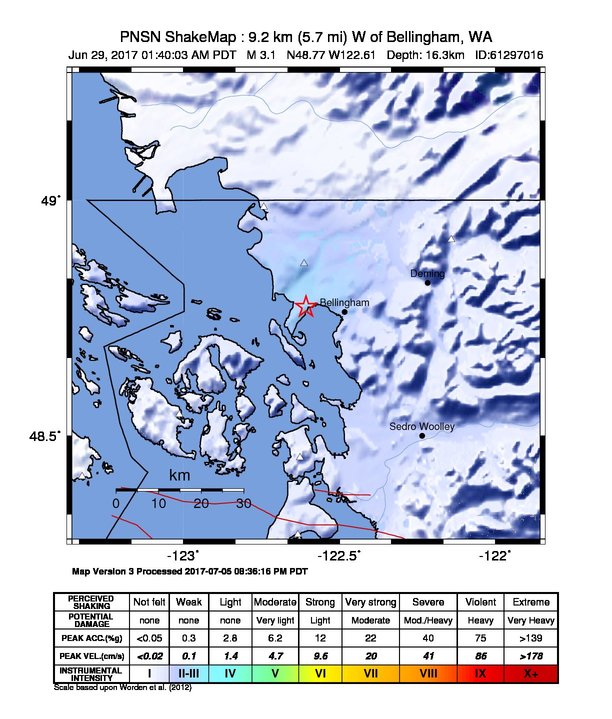
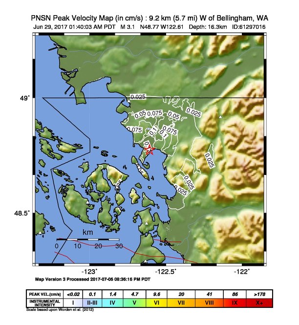
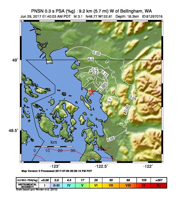
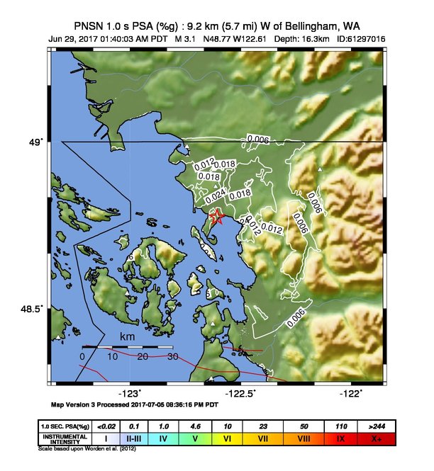
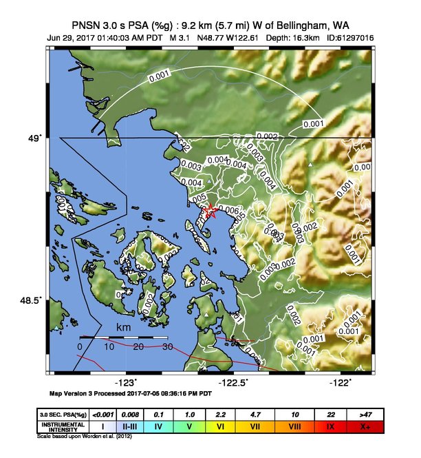
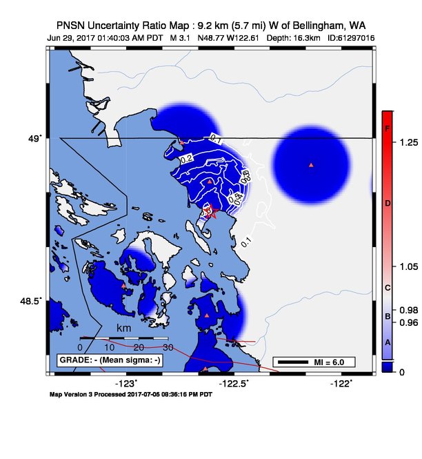
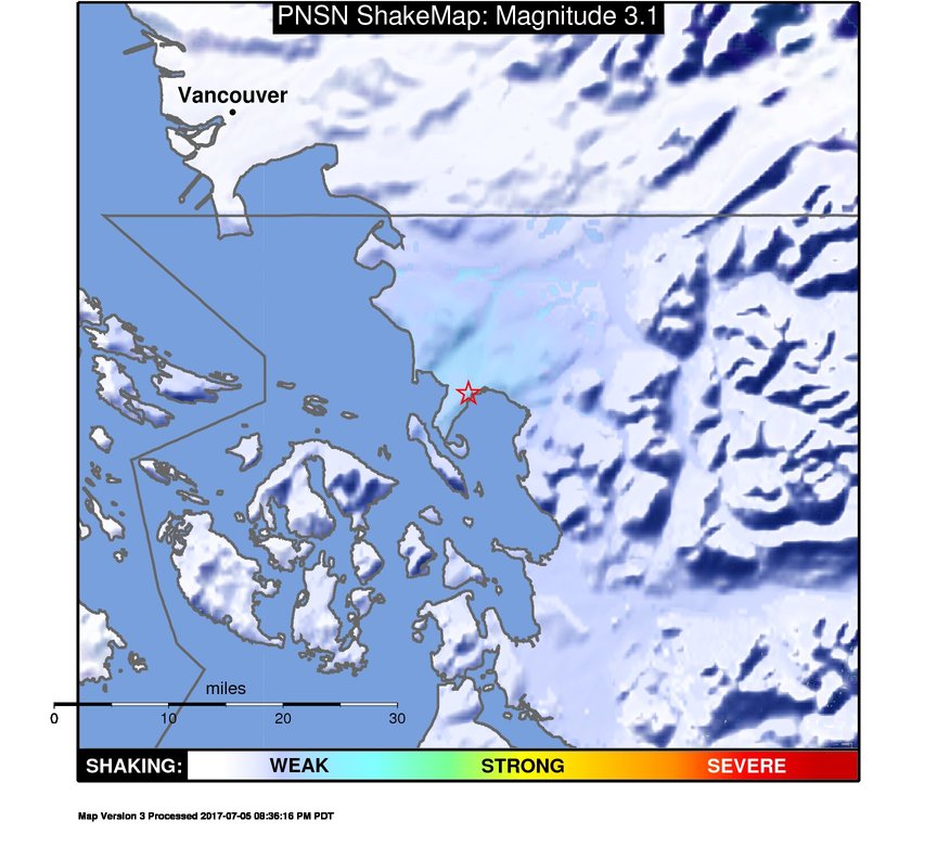
ShakeMap
Time:
Thu June 29, 2017 08:40:03 (UTC)
|
Depth:
16.27 km
|
Event ID:
61297016
|
Location:
48.774, -122.607


Downloads
| Regional | |
|---|---|
| intensity | JPG | PS.ZIP |
| acceleration | JPG | PS.ZIP |
| velocity | JPG | PS.ZIP |
| spectral 0.3 | JPG | PS.ZIP |
| spectral 1.0 | JPG | PS.ZIP |
| spectral 3.0 | JPG | PS.ZIP |
| uncertainty | JPG | PS.ZIP |
| tv map | JPG | PS.ZIP |
| tv map bare | JPG | PS.ZIP |
| tv info sheet | TXT |
| grid | XYZ.ZIP | XML.ZIP |
| gis | ZIP |
| station | TXT | XML |
| metadata | TXT |
Earthquake
| Event ID | Magnitude | Date | Time | Lat | Lon | Depth |
| 61297016 | 3.1 | // | :: | N48.77420 | W122.60720 | 16.27 km |
| Magnitude Bias: | MMI | PGA | PGV | PSA 0.3 | PSA 1.0 | PSA 3.0 |
| -1.29 | 0.12 | 0.23 | 0.19 | 0.33 | 0.69 |
Seismic Stations
| CN.VGZ: | Victoria Gonzales, BC, CA | Agency: Canadian National Seismic Network | |||
| Lat: 48.41310 Lon: -123.32510 Distance: 68.30 km from source | |||||
| Intensity: 1.0 | |||||
| Station Comp | Max Vel (cm/s) | Max Acc (%g) | PSA: 0.3 sec (%g) | 1.0 sec (%g) | 3.0 sec (%g) |
| --.HHE | 0.0013 | 0.0105 | 0.0054 | 0.0003 | 0.0000 -T |
| --.HHN | 0.0018 | 0.0140 | 0.0056 | 0.0003 | 0.0000 -T |
| UW.ERW: | Mt. Erie, WA, USA | Agency: Pacific Northwest Seismic Network | |||
| Lat: 48.45383 Lon: -122.62612 Distance: 39.19 km from source | |||||
| Intensity: 1.0 | |||||
| Station Comp | Max Vel (cm/s) | Max Acc (%g) | PSA: 0.3 sec (%g) | 1.0 sec (%g) | 3.0 sec (%g) |
| --.HNN | 0.0056 | 0.0269 | 0.0214 | 0.0014 | 0.0002 |
| --.HNE | 0.0063 | 0.0179 | 0.0137 | 0.0018 | 0.0002 |
| UW.MBKE: | M Baker Kendall ANSS-SMO | Agency: Pacific Northwest Regional Seismic Network | |||
| Lat: 48.91638 Lon: -122.14175 Distance: 40.92 km from source | |||||
| Intensity: 1.0 | |||||
| Station Comp | Max Vel (cm/s) | Max Acc (%g) | PSA: 0.3 sec (%g) | 1.0 sec (%g) | 3.0 sec (%g) |
| --.ENN | 0.0043 | 0.0231 | 0.0248 | 0.0031 | 0.0002 |
| --.ENE | 0.0044 | 0.0153 | 0.0189 | 0.0039 | 0.0002 |
| UW.QJLF: | Peace Portal Dr. Blaine, WA | Agency: Pacific Northwest Regional Seismic Network | |||
| Lat: 48.98512 Lon: -122.74295 Distance: 30.22 km from source | |||||
| Intensity: 1.7 | |||||
| Station Comp | Max Vel (cm/s) | Max Acc (%g) | PSA: 0.3 sec (%g) | 1.0 sec (%g) | 3.0 sec (%g) |
| 01.HNN | 0.0319 | 0.1051 | 0.1051 | 0.0090 | 0.0016 |
| 01.HNE | 0.0281 | 0.0540 | 0.1278 | 0.0077 | 0.0017 |
| 01.HNZ | 0.0093 | 0.0550 | 0.0349 | 0.0047 | 0.0019 |
| UW.QRWC: | Tyler Ln. Ferndale, WA | Agency: Pacific Northwest Regional Seismic Network | |||
| Lat: 48.86541 Lon: -122.61349 Distance: 19.18 km from source | |||||
| Intensity: 2.7 | |||||
| Station Comp | Max Vel (cm/s) | Max Acc (%g) | PSA: 0.3 sec (%g) | 1.0 sec (%g) | 3.0 sec (%g) |
| 01.HNN | 0.1104 | 0.5650 | 0.3044 | 0.0220 | 0.0041 |
| 01.HNE | 0.0979 | 0.6519 | 0.2796 | 0.0177 | 0.0032 |
| 01.HNZ | 0.0309 | 0.2205 | 0.0937 | 0.0049 | 0.0014 |
| UW.SVOH: | Skagit Valley CC ANSS-SMO | Agency: Pacific Northwest Regional Seismic Network | |||
| Lat: 48.28920 Lon: -122.63316 Distance: 56.36 km from source | |||||
| Intensity: 1.0 | |||||
| Station Comp | Max Vel (cm/s) | Max Acc (%g) | PSA: 0.3 sec (%g) | 1.0 sec (%g) | 3.0 sec (%g) |
| --.ENN | 0.0063 | 0.0217 | 0.0288 | 0.0031 | 0.0008 |
| --.ENE | 0.0075 | 0.0218 | 0.0307 | 0.0023 | 0.0009 |
| UW.UWFH: | UW Friday Harbor ANSS-SMO | Agency: Pacific Northwest Regional Seismic Network | |||
| Lat: 48.54593 Lon: -123.01324 Distance: 42.41 km from source | |||||
| Intensity: 1.0 | |||||
| Station Comp | Max Vel (cm/s) | Max Acc (%g) | PSA: 0.3 sec (%g) | 1.0 sec (%g) | 3.0 sec (%g) |
| --.ENN | 0.0074 | 0.0135 | 0.0099 | 0.0014 | 0.0013 |
| --.ENE | 0.0056 | 0.0194 | 0.0048 | 0.0011 | 0.0009 |