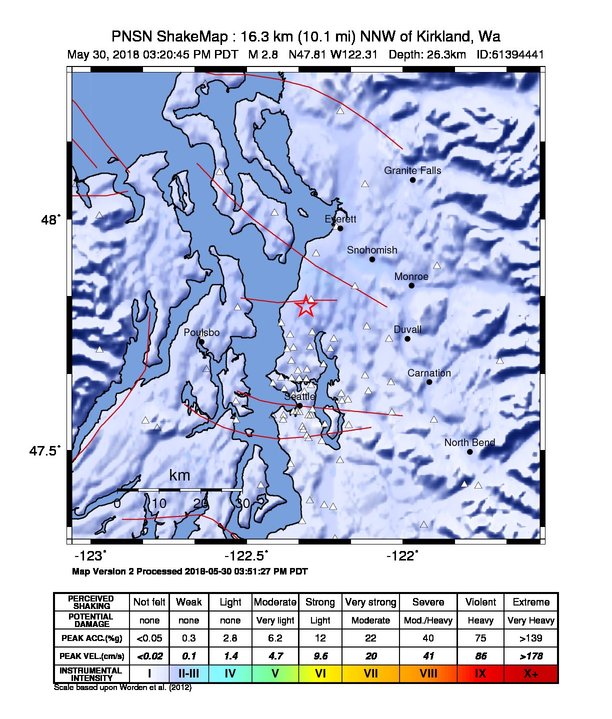
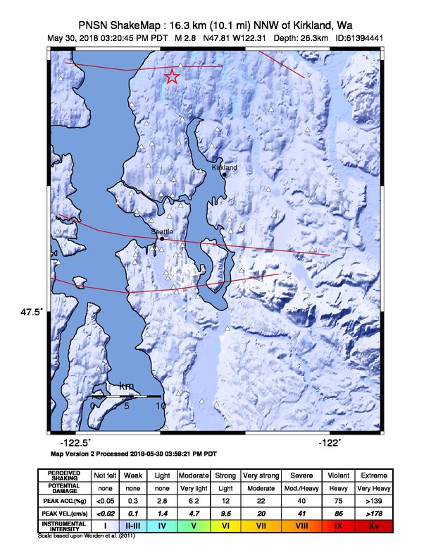
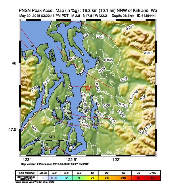
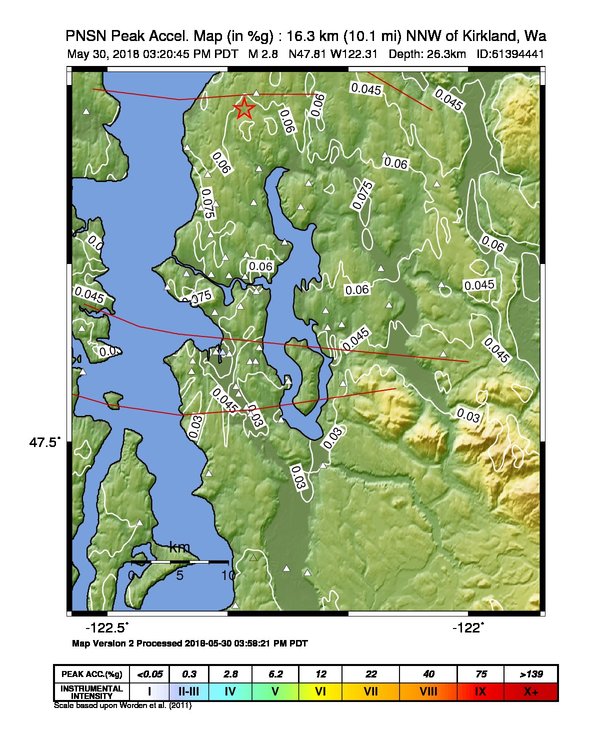
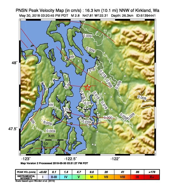
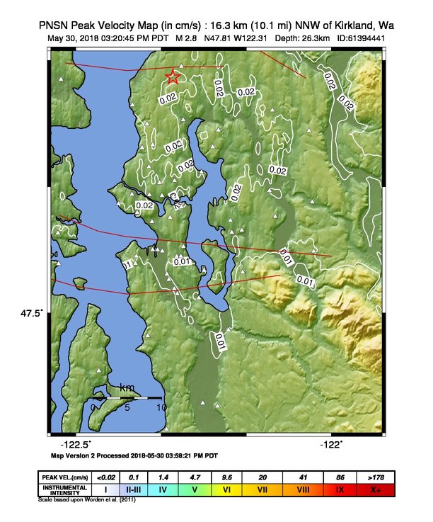
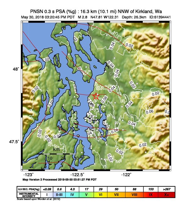
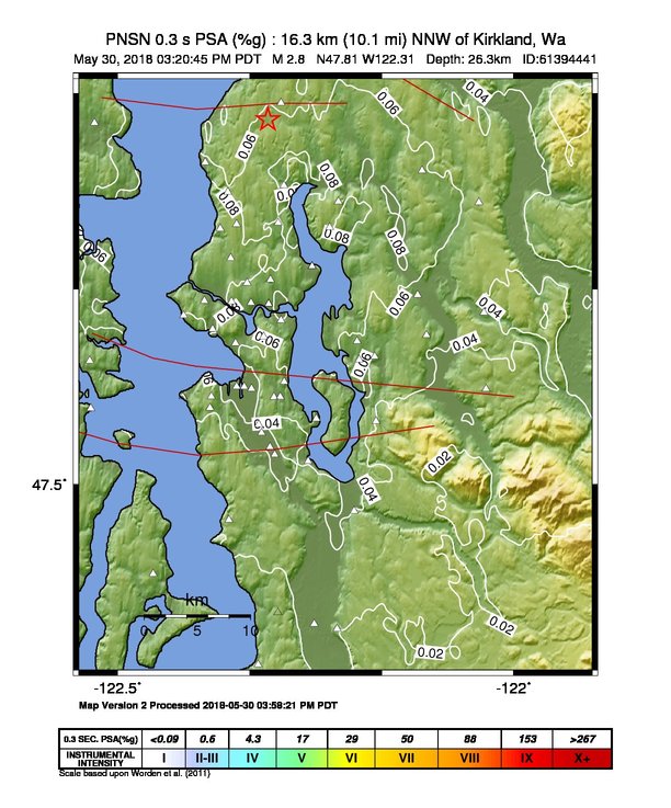
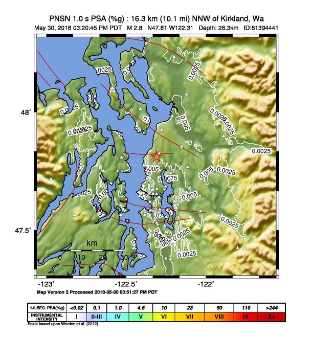
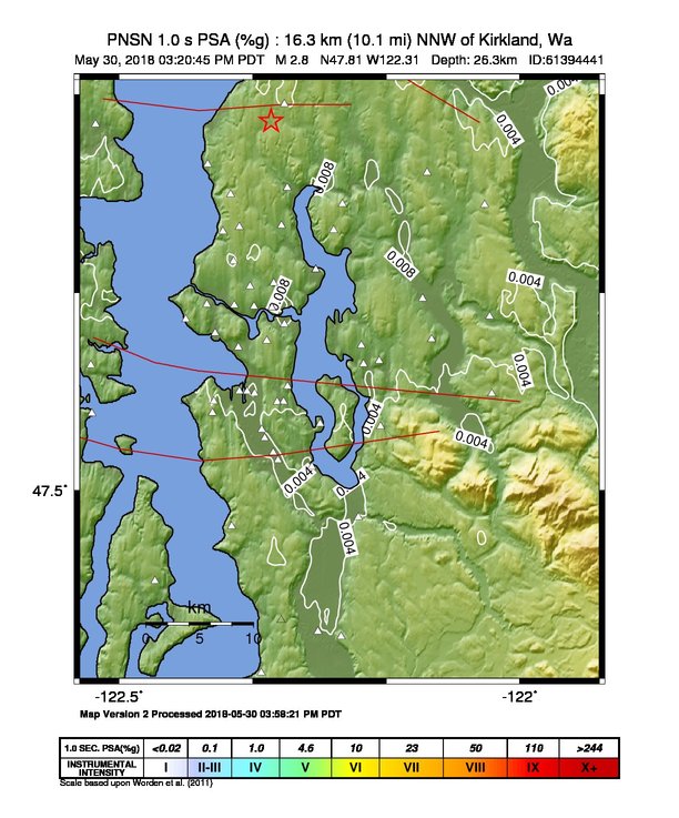
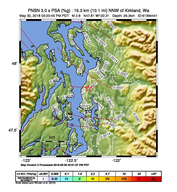
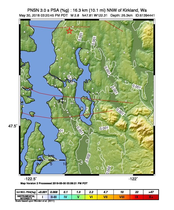
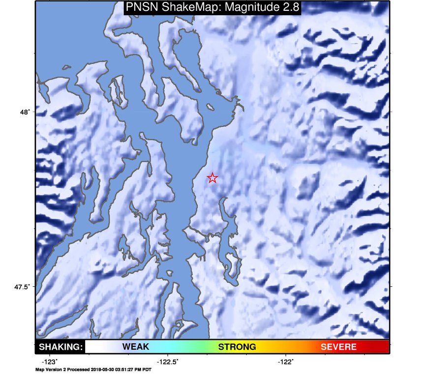
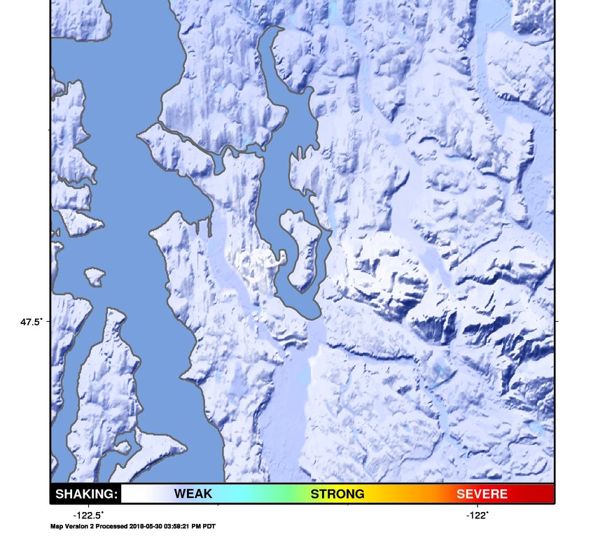
ShakeMap
Time:
Wed May 30, 2018 22:20:45 (UTC)
|
Depth:
25.0 km
|
Event ID:
61394441
|
Location:
47.803, -122.319


Downloads
| Regional | High Resolution Seattle | |
|---|---|---|
| intensity | JPG | PS.ZIP | JPG | PS.ZIP |
| acceleration | JPG | PS.ZIP | JPG | PS.ZIP |
| velocity | JPG | PS.ZIP | JPG | PS.ZIP |
| spectral 0.3 | JPG | PS.ZIP | JPG | PS.ZIP |
| spectral 1.0 | JPG | PS.ZIP | JPG | PS.ZIP |
| spectral 3.0 | JPG | PS.ZIP | JPG | PS.ZIP |
| uncertainty | JPG | PS.ZIP | JPG | PS.ZIP |
| tv map | JPG | PS.ZIP | JPG | PS.ZIP |
| tv map bare | JPG | PS.ZIP | JPG | PS.ZIP |
| tv info sheet | TXT | TXT |
| grid | XYZ.ZIP | XML.ZIP | XYZ.ZIP | XML.ZIP |
| gis | ZIP | ZIP |
| station | TXT | XML | TXT | XML |
| metadata | TXT | TXT |
Earthquake
| Event ID | Magnitude | Date | Time | Lat | Lon | Depth |
| 61394441 | 2.8 | // | :: | N47.81120 | W122.31030 | 26.29 km |
| Magnitude Bias: | MMI | PGA | PGV | PSA 0.3 | PSA 1.0 | PSA 3.0 |
| 0.00 | 0.26 | 0.25 | 0.30 | 0.45 | 0.61 |
Seismic Stations
| UW.ALCT: | Alcott School, Redmond ANSS-SMO | Agency: Pacific Northwest Regional Seismic Network | |||
| Lat: 47.64690 Lon: -122.03770 Distance: 37.96 km from source | |||||
| Intensity: 1.2 | |||||
| Station Comp | Max Vel (cm/s) | Max Acc (%g) | PSA: 0.3 sec (%g) | 1.0 sec (%g) | 3.0 sec (%g) |
| --.ENN | 0.0157 | 0.0541 | 0.0620 | 0.0056 | 0.0004 |
| --.ENE | 0.0191 | 0.0718 | 0.0549 | 0.0028 | 0.0006 |
| UW.ALKI: | Alki Wastewater Plant, Seattle, WA, USA | Agency: Pacific Northwest Seismic Network | |||
| Lat: 47.57510 Lon: -122.41760 Distance: 38.01 km from source | |||||
| Intensity: NaN | |||||
| Station Comp | Max Vel (cm/s) | Max Acc (%g) | PSA: 0.3 sec (%g) | 1.0 sec (%g) | 3.0 sec (%g) |
| --.HNN | 0.0026 -G | 0.0087 -G | 0.0110 -G | 0.0010 -G | 0.0001 -G |
| --.HNE | 0.0013 -G | 0.0040 -G | 0.0061 -G | 0.0010 -G | 0.0001 -G |
| UW.BABE: | Bainbridge School ANSS-SMO | Agency: Pacific Northwest Regional Seismic Network | |||
| Lat: 47.60583 Lon: -122.53528 Distance: 38.68 km from source | |||||
| Intensity: 1.0 | |||||
| Station Comp | Max Vel (cm/s) | Max Acc (%g) | PSA: 0.3 sec (%g) | 1.0 sec (%g) | 3.0 sec (%g) |
| --.ENN | 0.0072 | 0.0137 | 0.0120 | 0.0020 | 0.0005 |
| --.ENE | 0.0066 | 0.0128 | 0.0126 | 0.0013 | 0.0008 |
| UW.BEVT: | Boeing Everett ANSS-SMO | Agency: Pacific Northwest Regional Seismic Network | |||
| Lat: 47.92497 Lon: -122.27811 Distance: 29.27 km from source | |||||
| Intensity: 1.1 | |||||
| Station Comp | Max Vel (cm/s) | Max Acc (%g) | PSA: 0.3 sec (%g) | 1.0 sec (%g) | 3.0 sec (%g) |
| --.ENN | 0.0106 | 0.0491 | 0.0306 | 0.0034 | 0.0010 |
| --.ENE | 0.0169 | 0.0810 | 0.0554 | 0.0037 | 0.0009 |
| UW.BLN: | Blyn Mt., WA, USA | Agency: Pacific Northwest Seismic Network | |||
| Lat: 48.00662 Lon: -122.97265 Distance: 60.00 km from source | |||||
| Intensity: NaN | |||||
| Station Comp | Max Vel (cm/s) | Max Acc (%g) | PSA: 0.3 sec (%g) | 1.0 sec (%g) | 3.0 sec (%g) |
| --.HNN | 0.0020 -G | 0.0087 -G | 0.0043 -G | 0.0003 -G | 0.0001 -G |
| --.HNE | 0.0018 | 0.0106 | 0.0047 | 0.0002 | 0.0001 |
| UW.BNG: | Boeing Field King Co International | Agency: Pacific Northwest Seismic Network | |||
| Lat: 47.52547 Lon: -122.30166 Distance: 41.24 km from source | |||||
| Intensity: 1.0 | |||||
| Station Comp | Max Vel (cm/s) | Max Acc (%g) | PSA: 0.3 sec (%g) | 1.0 sec (%g) | 3.0 sec (%g) |
| --.HNN | 0.0073 | 0.0333 | 0.0410 | 0.0026 | 0.0002 |
| --.HNE | 0.0086 | 0.0337 | 0.0354 | 0.0032 | 0.0002 |
| UW.BRKS: | Brookside ANSS-SMO | Agency: Pacific Northwest Regional Seismic Network | |||
| Lat: 47.75520 Lon: -122.29013 Distance: 27.06 km from source | |||||
| Intensity: 1.2 - T | |||||
| Station Comp | Max Vel (cm/s) | Max Acc (%g) | PSA: 0.3 sec (%g) | 1.0 sec (%g) | 3.0 sec (%g) |
| --.ENN | 0.0185 | 0.0547 | 0.0567 | 0.0083 | 0.0007 |
| --.ENE | 0.0185 | 0.0580 | 0.0580 | 0.0040 | 0.0003 |
| UW.BSFP: | Boeing Fire Protection | Agency: Pacific Northwest Regional Seismic Network | |||
| Lat: 47.53186 Lon: -122.30777 Distance: 40.69 km from source | |||||
| Intensity: 1.0 | |||||
| Station Comp | Max Vel (cm/s) | Max Acc (%g) | PSA: 0.3 sec (%g) | 1.0 sec (%g) | 3.0 sec (%g) |
| --.ENN | 0.0103 | 0.0361 | 0.0716 | 0.0059 | 0.0004 |
| --.ENE | 0.0098 | 0.0372 | 0.0430 | 0.0039 | 0.0003 |
| UW.CDMR: | Cedar Moraine SMO | Agency: Pacific Northwest Regional Seismic Network | |||
| Lat: 47.42226 Lon: -121.75779 Distance: 65.40 km from source | |||||
| Intensity: 1.0 | |||||
| Station Comp | Max Vel (cm/s) | Max Acc (%g) | PSA: 0.3 sec (%g) | 1.0 sec (%g) | 3.0 sec (%g) |
| --.ENN | 0.0040 | 0.0141 | 0.0288 | 0.0024 | 0.0001 |
| --.ENE | 0.0041 | 0.0138 | 0.0145 | 0.0009 | 0.0001 |
| UW.CTR: | Seattle Center | Agency: Pacific Northwest Seismic Network | |||
| Lat: 47.62070 Lon: -122.35140 Distance: 33.90 km from source | |||||
| Intensity: 1.2 | |||||
| Station Comp | Max Vel (cm/s) | Max Acc (%g) | PSA: 0.3 sec (%g) | 1.0 sec (%g) | 3.0 sec (%g) |
| --.HNN | 0.0180 | 0.0608 | 0.0687 | 0.0057 | 0.0006 |
| --.HNE | 0.0061 | 0.0250 | 0.0175 | 0.0013 | 0.0002 |
| UW.DOSE: | Dosewallips old TA.C04A, WA | Agency: Pacific Northwest Regional Seismic Network | |||
| Lat: 47.71720 Lon: -122.97180 Distance: 56.96 km from source | |||||
| Intensity: 1.0 | |||||
| Station Comp | Max Vel (cm/s) | Max Acc (%g) | PSA: 0.3 sec (%g) | 1.0 sec (%g) | 3.0 sec (%g) |
| --.BHE | 0.0061 | 0.0323 | 0.0227 | 0.0008 | 0.0001 |
| --.BHN | 0.0045 | 0.0232 | 0.0230 | 0.0008 | 0.0001 |
| UW.EARN: | East Ridge ES ANSS-SMO | Agency: Pacific Northwest Regional Seismic Network | |||
| Lat: 47.74090 Lon: -122.04380 Distance: 33.89 km from source | |||||
| Intensity: 1.0 | |||||
| Station Comp | Max Vel (cm/s) | Max Acc (%g) | PSA: 0.3 sec (%g) | 1.0 sec (%g) | 3.0 sec (%g) |
| --.ENN | 0.0081 | 0.0269 | 0.0237 | 0.0037 | 0.0004 |
| --.ENE | 0.0040 | 0.0143 | 0.0150 | 0.0025 | 0.0003 |
| UW.EVGW: | Everett Gateway Middle School ANSS-SMO | Agency: Pacific Northwest Regional Seismic Network | |||
| Lat: 47.85440 Lon: -122.15338 Distance: 29.18 km from source | |||||
| Intensity: 1.0 | |||||
| Station Comp | Max Vel (cm/s) | Max Acc (%g) | PSA: 0.3 sec (%g) | 1.0 sec (%g) | 3.0 sec (%g) |
| --.ENN | 0.0063 | 0.0242 | 0.0252 | 0.0026 | 0.0003 |
| --.ENE | 0.0066 | 0.0245 | 0.0231 | 0.0018 | 0.0002 |
| UW.FINN: | Finn Hill Jr High ANSS-SMO | Agency: Pacific Northwest Regional Seismic Network | |||
| Lat: 47.71950 Lon: -122.23220 Distance: 28.80 km from source | |||||
| Intensity: 1.6 | |||||
| Station Comp | Max Vel (cm/s) | Max Acc (%g) | PSA: 0.3 sec (%g) | 1.0 sec (%g) | 3.0 sec (%g) |
| --.ENN | 0.0263 | 0.0713 | 0.0829 | 0.0065 | 0.0008 |
| --.ENE | 0.0117 | 0.0627 | 0.0316 | 0.0030 | 0.0006 |
| UW.GMW: | Gold Mt. | Agency: Pacific Northwest Regional Seismic Network | |||
| Lat: 47.54773 Lon: -122.78759 Distance: 53.16 km from source | |||||
| Intensity: NaN | |||||
| Station Comp | Max Vel (cm/s) | Max Acc (%g) | PSA: 0.3 sec (%g) | 1.0 sec (%g) | 3.0 sec (%g) |
| --.ENN | 0.0036 | 0.0124 | 0.0065 | 0.0003 | 0.0002 |
| --.ENE | 0.0023 -G | 0.0095 -G | 0.0046 -G | 0.0004 -G | 0.0002 -G |
| UW.GNW: | Green Mountain (BB) CREST SMO | Agency: Pacific Northwest Regional Seismic Network | |||
| Lat: 47.56413 Lon: -122.82498 Distance: 54.13 km from source | |||||
| Intensity: 1.0 | |||||
| Station Comp | Max Vel (cm/s) | Max Acc (%g) | PSA: 0.3 sec (%g) | 1.0 sec (%g) | 3.0 sec (%g) |
| --.BHE | 0.0111 | 0.0419 | 0.0200 | 0.0012 | 0.0001 |
| --.BHN | 0.0038 | 0.0182 | 0.0111 | 0.0006 | 0.0001 |
| UW.GRE: | Greenlake, Seattle, WA | Agency: Pacific Northwest Seismic Network | |||
| Lat: 47.67223 Lon: -122.33651 Distance: 30.56 km from source | |||||
| Intensity: 1.3 | |||||
| Station Comp | Max Vel (cm/s) | Max Acc (%g) | PSA: 0.3 sec (%g) | 1.0 sec (%g) | 3.0 sec (%g) |
| --.HNN | 0.0199 | 0.0811 | 0.0706 | 0.0055 | 0.0007 |
| --.HNE | 0.0080 | 0.0558 | 0.0272 | 0.0018 | 0.0002 |
| UW.GTWN: | Georgetown Playfield ANSS-SMO | Agency: Pacific Northwest Regional Seismic Network | |||
| Lat: 47.55121 Lon: -122.32201 Distance: 39.09 km from source | |||||
| Intensity: 1.0 | |||||
| Station Comp | Max Vel (cm/s) | Max Acc (%g) | PSA: 0.3 sec (%g) | 1.0 sec (%g) | 3.0 sec (%g) |
| --.ENN | 0.0083 | 0.0324 | 0.0810 | 0.0054 | 0.0004 |
| --.ENE | 0.0068 | 0.0259 | 0.0628 | 0.0037 | 0.0003 |
| UW.HART: | Harbor Island, ANSS-SMO | Agency: Pacific Northwest Seismic Network | |||
| Lat: 47.58376 Lon: -122.35010 Distance: 36.60 km from source | |||||
| Intensity: 1.4 | |||||
| Station Comp | Max Vel (cm/s) | Max Acc (%g) | PSA: 0.3 sec (%g) | 1.0 sec (%g) | 3.0 sec (%g) |
| --.HNN | 0.0223 | 0.0664 | 0.0963 | 0.0088 | 0.0008 |
| --.HNE | 0.0169 | 0.0394 | 0.0618 | 0.0054 | 0.0003 |
| UW.HICC: | Highline CC ANSS-SMO | Agency: Pacific Northwest Regional Seismic Network | |||
| Lat: 47.39012 Lon: -122.29790 Distance: 53.71 km from source | |||||
| Intensity: NaN | |||||
| Station Comp | Max Vel (cm/s) | Max Acc (%g) | PSA: 0.3 sec (%g) | 1.0 sec (%g) | 3.0 sec (%g) |
| --.ENN | 0.0031 -G | 0.0060 -G | 0.0050 -G | 0.0008 -G | 0.0005 -G |
| --.ENE | 0.0054 -G | 0.0047 -G | 0.0051 -G | 0.0012 -G | 0.0005 -G |
| UW.HOLY: | Holy Rosary ANSS-SMO | Agency: Pacific Northwest Regional Seismic Network | |||
| Lat: 47.56540 Lon: -122.38360 Distance: 38.32 km from source | |||||
| Intensity: 1.0 | |||||
| Station Comp | Max Vel (cm/s) | Max Acc (%g) | PSA: 0.3 sec (%g) | 1.0 sec (%g) | 3.0 sec (%g) |
| --.ENN | 0.0048 | 0.0159 | 0.0251 | 0.0028 | 0.0003 |
| --.ENE | 0.0044 | 0.0160 | 0.0205 | 0.0017 | 0.0002 |
| UW.KCAM: | King County Airport Maint. Shop, ANSS-SMO | Agency: Pacific Northwest Seismic Network | |||
| Lat: 47.54420 Lon: -122.31853 Distance: 39.66 km from source | |||||
| Intensity: 1.0 | |||||
| Station Comp | Max Vel (cm/s) | Max Acc (%g) | PSA: 0.3 sec (%g) | 1.0 sec (%g) | 3.0 sec (%g) |
| --.HNN | 0.0053 | 0.0244 | 0.0246 | 0.0036 | 0.0003 |
| --.HNE | 0.0047 | 0.0237 | 0.0269 | 0.0034 | 0.0002 |
| UW.KIMB: | Kimball School ANSS-SMO | Agency: Pacific Northwest Regional Seismic Network | |||
| Lat: 47.57480 Lon: -122.30280 Distance: 37.18 km from source | |||||
| Intensity: 1.0 | |||||
| Station Comp | Max Vel (cm/s) | Max Acc (%g) | PSA: 0.3 sec (%g) | 1.0 sec (%g) | 3.0 sec (%g) |
| --.ENN | 0.0079 | 0.0159 | 0.0202 | 0.0039 | 0.0005 |
| --.ENE | 0.0058 | 0.0166 | 0.0196 | 0.0023 | 0.0005 |
| UW.KINR: | Kitsap Road Shed ANSS-SMO | Agency: Pacific Northwest Regional Seismic Network | |||
| Lat: 47.75167 Lon: -122.64306 Distance: 36.79 km from source | |||||
| Intensity: 1.0 | |||||
| Station Comp | Max Vel (cm/s) | Max Acc (%g) | PSA: 0.3 sec (%g) | 1.0 sec (%g) | 3.0 sec (%g) |
| --.ENN | 0.0058 | 0.0211 | 0.0147 | 0.0010 | 0.0008 |
| --.ENE | 0.0124 | 0.0430 | 0.0218 | 0.0023 | 0.0008 |
| UW.KITP: | Kitsap Treatment Plant ANSS-SMO | Agency: Pacific Northwest Regional Seismic Network | |||
| Lat: 47.67520 Lon: -122.62974 Distance: 38.61 km from source | |||||
| Intensity: NaN | |||||
| Station Comp | Max Vel (cm/s) | Max Acc (%g) | PSA: 0.3 sec (%g) | 1.0 sec (%g) | 3.0 sec (%g) |
| --.ENN | 0.0031 -G | 0.0094 -G | 0.0139 -G | 0.0012 -G | 0.0001 -G |
| --.ENE | 0.0018 -G | 0.0094 -G | 0.0116 -G | 0.0009 -G | 0.0002 -G |
| UW.KNEL: | Kent Elementary ANSS-SMO | Agency: Pacific Northwest Regional Seismic Network | |||
| Lat: 47.38052 Lon: -122.25193 Distance: 54.81 km from source | |||||
| Intensity: 1.0 | |||||
| Station Comp | Max Vel (cm/s) | Max Acc (%g) | PSA: 0.3 sec (%g) | 1.0 sec (%g) | 3.0 sec (%g) |
| --.ENN | 0.0058 | 0.0172 | 0.0317 | 0.0030 | 0.0005 |
| --.ENE | 0.0054 | 0.0133 | 0.0302 | 0.0032 | 0.0004 |
| UW.LAWT: | Lawton, Seattle, WA, USA | Agency: Pacific Northwest Seismic Network | |||
| Lat: 47.65694 Lon: -122.39062 Distance: 31.96 km from source | |||||
| Intensity: 2.1 | |||||
| Station Comp | Max Vel (cm/s) | Max Acc (%g) | PSA: 0.3 sec (%g) | 1.0 sec (%g) | 3.0 sec (%g) |
| --.ENN | 0.0461 | 0.1662 | 0.1717 | 0.0104 | 0.0013 |
| --.ENE | 0.0114 | 0.0490 | 0.0347 | 0.0027 | 0.0003 |
| UW.LEOT: | Leota J. High ANSS-SMO | Agency: Pacific Northwest Regional Seismic Network | |||
| Lat: 47.76790 Lon: -122.11560 Distance: 30.43 km from source | |||||
| Intensity: 1.5 | |||||
| Station Comp | Max Vel (cm/s) | Max Acc (%g) | PSA: 0.3 sec (%g) | 1.0 sec (%g) | 3.0 sec (%g) |
| --.ENN | 0.0248 | 0.0655 | 0.0876 | 0.0058 | 0.0006 |
| --.ENE | 0.0131 | 0.0442 | 0.0306 | 0.0026 | 0.0004 |
| UW.LYNC: | Lynnwood City Hall, ANSS-SMO | Agency: Pacific Northwest Regional Seismic Network | |||
| Lat: 47.82555 Lon: -122.29384 Distance: 26.37 km from source | |||||
| Intensity: 1.0 - T | |||||
| Station Comp | Max Vel (cm/s) | Max Acc (%g) | PSA: 0.3 sec (%g) | 1.0 sec (%g) | 3.0 sec (%g) |
| --.ENN | 0.0053 | 0.0280 | 0.0167 | 0.0014 | 0.0002 |
| --.ENE | 0.0066 | 0.0188 | 0.0242 | 0.0018 | 0.0002 |
| UW.MARY: | Marymoor Park ANSS-SMO | Agency: Pacific Northwest Seismic Network | |||
| Lat: 47.66195 Lon: -122.12142 Distance: 34.15 km from source | |||||
| Intensity: 1.5 | |||||
| Station Comp | Max Vel (cm/s) | Max Acc (%g) | PSA: 0.3 sec (%g) | 1.0 sec (%g) | 3.0 sec (%g) |
| --.ENN | 0.0244 | 0.0930 | 0.0662 | 0.0065 | 0.0009 |
| --.ENE | 0.0203 | 0.1052 | 0.0519 | 0.0045 | 0.0004 |
| UW.MBPA: | Monroe BPA, WA, USA | Agency: Pacific Northwest Seismic Network | |||
| Lat: 47.89835 Lon: -121.89018 Distance: 42.04 km from source | |||||
| Intensity: 1.0 | |||||
| Station Comp | Max Vel (cm/s) | Max Acc (%g) | PSA: 0.3 sec (%g) | 1.0 sec (%g) | 3.0 sec (%g) |
| --.ENN | 0.0041 | 0.0226 | 0.0085 | 0.0017 | 0.0004 |
| --.ENE | 0.0047 | 0.0207 | 0.0118 | 0.0025 | 0.0007 |
| UW.MNWA: | Manchester, WA | Agency: Pacific Northwest Seismic Network | |||
| Lat: 47.56503 Lon: -122.53414 Distance: 41.49 km from source | |||||
| Intensity: 1.0 | |||||
| Station Comp | Max Vel (cm/s) | Max Acc (%g) | PSA: 0.3 sec (%g) | 1.0 sec (%g) | 3.0 sec (%g) |
| --.HNN | 0.0018 | 0.0109 | 0.0062 | 0.0004 | 0.0001 |
| --.HNE | 0.0033 | 0.0176 | 0.0070 | 0.0005 | 0.0001 |
| UW.MPL: | Maple Valley SMO | Agency: Pacific Northwest Regional Seismic Network | |||
| Lat: 47.68630 Lon: -122.25444 Distance: 30.02 km from source | |||||
| Intensity: NaN | |||||
| Station Comp | Max Vel (cm/s) | Max Acc (%g) | PSA: 0.3 sec (%g) | 1.0 sec (%g) | 3.0 sec (%g) |
| --.ENN | 0.0047 -G | 0.0077 -G | 0.0165 -G | 0.0014 -G | 0.0005 -G |
| --.ENE | 0.0049 | 0.0102 | 0.0169 | 0.0015 | 0.0010 |
| UW.NIHS: | Inglemoor HS ANSS-SMO | Agency: Pacific Northwest Regional Seismic Network | |||
| Lat: 47.74144 Lon: -122.22141 Distance: 28.20 km from source | |||||
| Intensity: 1.6 | |||||
| Station Comp | Max Vel (cm/s) | Max Acc (%g) | PSA: 0.3 sec (%g) | 1.0 sec (%g) | 3.0 sec (%g) |
| --.ENN | 0.0288 | 0.0746 | 0.1162 | 0.0087 | 0.0013 |
| --.ENE | 0.0139 | 0.0674 | 0.0388 | 0.0023 | 0.0008 |
| UW.NOWS: | NOAA, Seattle, WA, USA | Agency: Pacific Northwest Seismic Network | |||
| Lat: 47.68630 Lon: -122.25444 Distance: 30.02 km from source | |||||
| Intensity: 1.4 | |||||
| Station Comp | Max Vel (cm/s) | Max Acc (%g) | PSA: 0.3 sec (%g) | 1.0 sec (%g) | 3.0 sec (%g) |
| --.ENN | 0.0230 | 0.0518 | 0.0986 | 0.0091 | 0.0010 |
| --.ENE | 0.0070 | 0.0298 | 0.0370 | 0.0022 | 0.0002 |
| UW.NWPT: | Newport, Bellevue, WA, USA | Agency: Pacific Northwest Regional Seismic Network | |||
| Lat: 47.55410 Lon: -122.17370 Distance: 40.16 km from source | |||||
| Intensity: 1.0 | |||||
| Station Comp | Max Vel (cm/s) | Max Acc (%g) | PSA: 0.3 sec (%g) | 1.0 sec (%g) | 3.0 sec (%g) |
| --.HNN | 0.0055 | 0.0319 | 0.0293 | 0.0028 | 0.0003 |
| --.HNE | 0.0042 | 0.0192 | 0.0309 | 0.0011 | 0.0001 |
| UW.PIE: | Pier 90, Seattle, WA, USA | Agency: Pacific Northwest Regional Seismic Network | |||
| Lat: 47.63270 Lon: -122.38030 Distance: 33.35 km from source | |||||
| Intensity: 1.8 | |||||
| Station Comp | Max Vel (cm/s) | Max Acc (%g) | PSA: 0.3 sec (%g) | 1.0 sec (%g) | 3.0 sec (%g) |
| --.HNN | 0.0330 | 0.1214 | 0.1210 | 0.0078 | 0.0009 |
| --.HNE | 0.0161 | 0.0427 | 0.0874 | 0.0028 | 0.0003 |
| UW.PIER: | Pier 30, Seattle, WA | Agency: Pacific Northwest Seismic Network | |||
| Lat: 47.58350 Lon: -122.34020 Distance: 36.57 km from source | |||||
| Intensity: 1.1 | |||||
| Station Comp | Max Vel (cm/s) | Max Acc (%g) | PSA: 0.3 sec (%g) | 1.0 sec (%g) | 3.0 sec (%g) |
| --.HNN | 0.0153 | 0.1342 | 0.0725 | 0.0109 | 0.0006 |
| --.HNE | 0.0166 | 0.2454 | 0.0585 | 0.0066 | 0.0006 |
| UW.PNLK: | Pine Lake JH ANSS-SMO | Agency: Pacific Northwest Seismic Network | |||
| Lat: 47.58162 Lon: -122.03483 Distance: 42.05 km from source | |||||
| Intensity: 1.0 | |||||
| Station Comp | Max Vel (cm/s) | Max Acc (%g) | PSA: 0.3 sec (%g) | 1.0 sec (%g) | 3.0 sec (%g) |
| --.HNN | 0.0031 | 0.0114 | 0.0113 | 0.0016 | 0.0002 |
| --.HNE | 0.0027 | 0.0123 | 0.0093 | 0.0010 | 0.0001 |
| UW.QARB: | UW Arboretum, Seattle, WA | Agency: Pacific Northwest Regional Seismic Network | |||
| Lat: 47.64031 Lon: -122.29381 Distance: 32.46 km from source | |||||
| Intensity: 1.3 | |||||
| Station Comp | Max Vel (cm/s) | Max Acc (%g) | PSA: 0.3 sec (%g) | 1.0 sec (%g) | 3.0 sec (%g) |
| 01.HNN | 0.0209 | 0.0759 | 0.0767 | 0.0088 | 0.0027 |
| 01.HNE | 0.0068 | 0.0337 | 0.0329 | 0.0030 | 0.0016 |
| 01.HNZ | 0.0077 | 0.0543 | 0.0222 | 0.0024 | 0.0010 |
| UW.QBIT: | Andersson Residence | Agency: Pacific Northwest Regional Seismic Network | |||
| Lat: 47.72215 Lon: -122.34992 Distance: 28.25 km from source | |||||
| Intensity: 1.3 | |||||
| Station Comp | Max Vel (cm/s) | Max Acc (%g) | PSA: 0.3 sec (%g) | 1.0 sec (%g) | 3.0 sec (%g) |
| 01.HNN | 0.0201 | 0.0768 | 0.0821 | 0.0055 | 0.0013 |
| 01.HNE | 0.0085 | 0.0229 | 0.0392 | 0.0028 | 0.0012 |
| 01.HNZ | 0.0095 | 0.0636 | 0.0293 | 0.0022 | 0.0017 |
| UW.QBOG: | Hedtke Residence | Agency: Pacific Northwest Regional Seismic Network | |||
| Lat: 47.69325 Lon: -122.35712 Distance: 29.59 km from source | |||||
| Intensity: 1.9 | |||||
| Station Comp | Max Vel (cm/s) | Max Acc (%g) | PSA: 0.3 sec (%g) | 1.0 sec (%g) | 3.0 sec (%g) |
| 01.HNN | 0.0381 | 0.1106 | 0.2002 | 0.0174 | 0.0018 |
| 01.HNE | 0.0181 | 0.0475 | 0.1257 | 0.0053 | 0.0016 |
| 01.HNZ | 0.0083 | 0.0412 | 0.0480 | 0.0032 | 0.0012 |
| UW.QBOV: | Oxrieder Residence | Agency: Pacific Northwest Regional Seismic Network | |||
| Lat: 47.62231 Lon: -122.19760 Distance: 34.69 km from source | |||||
| Intensity: 1.1 | |||||
| Station Comp | Max Vel (cm/s) | Max Acc (%g) | PSA: 0.3 sec (%g) | 1.0 sec (%g) | 3.0 sec (%g) |
| 01.HNN | 0.0155 | 0.0450 | 0.0433 | 0.0048 | 0.0015 |
| 01.HNE | 0.0102 | 0.0354 | 0.0329 | 0.0033 | 0.0020 |
| 01.HNZ | 0.0060 | 0.0233 | 0.0332 | 0.0023 | 0.0011 |
| UW.QBRO: | 81st Dr NE, Marysville, WA | Agency: Pacific Northwest Regional Seismic Network | |||
| Lat: 48.07397 Lon: -122.12118 Distance: 41.75 km from source | |||||
| Intensity: 1.0 | |||||
| Station Comp | Max Vel (cm/s) | Max Acc (%g) | PSA: 0.3 sec (%g) | 1.0 sec (%g) | 3.0 sec (%g) |
| 01.HNN | 0.0041 | 0.0266 | 0.0192 | 0.0037 | 0.0016 |
| 01.HNE | 0.0044 | 0.0415 | 0.0172 | 0.0022 | 0.0013 |
| 01.HNZ | 0.0062 | 0.1157 | 0.0151 | 0.0022 | 0.0015 |
| UW.QBUS: | 258th NE, Arlington, WA | Agency: Pacific Northwest Regional Seismic Network | |||
| Lat: 48.23098 Lon: -122.20043 Distance: 54.19 km from source | |||||
| Intensity: 1.0 | |||||
| Station Comp | Max Vel (cm/s) | Max Acc (%g) | PSA: 0.3 sec (%g) | 1.0 sec (%g) | 3.0 sec (%g) |
| 01.HNN | 0.0043 | 0.0180 | 0.0279 | 0.0022 | 0.0011 |
| 01.HNE | 0.0081 | 0.0273 | 0.0498 | 0.0025 | 0.0017 |
| 01.HNZ | 0.0053 | 0.0309 | 0.0092 | 0.0019 | 0.0017 |
| UW.QCDG: | Bakken Rd. Greenback, WA | Agency: Pacific Northwest Regional Seismic Network | |||
| Lat: 48.10002 Lon: -122.58696 Distance: 46.34 km from source | |||||
| Intensity: 1.0 | |||||
| Station Comp | Max Vel (cm/s) | Max Acc (%g) | PSA: 0.3 sec (%g) | 1.0 sec (%g) | 3.0 sec (%g) |
| 01.HNN | 0.0054 | 0.0152 | 0.0151 | 0.0024 | 0.0018 |
| 01.HNE | 0.0057 | 0.0190 | 0.0228 | 0.0023 | 0.0018 |
| 01.HNZ | 0.0063 | 0.0343 | 0.0135 | 0.0020 | 0.0016 |
| UW.QCOR: | Corliss Ave N., Seattle, WA | Agency: Pacific Northwest Regional Seismic Network | |||
| Lat: 47.65514 Lon: -122.33183 Distance: 31.54 km from source | |||||
| Intensity: 1.1 | |||||
| Station Comp | Max Vel (cm/s) | Max Acc (%g) | PSA: 0.3 sec (%g) | 1.0 sec (%g) | 3.0 sec (%g) |
| 01.HNN | 0.0165 | 0.0523 | 0.0688 | 0.0056 | 0.0019 |
| 01.HNE | 0.0063 | 0.0258 | 0.0338 | 0.0025 | 0.0016 |
| 01.HNZ | 0.0049 | 0.0361 | 0.0118 | 0.0024 | 0.0013 |
| UW.QEGA: | Grand Ave, Everett, WA | Agency: Pacific Northwest Regional Seismic Network | |||
| Lat: 47.98284 Lon: -122.21261 Distance: 33.29 km from source | |||||
| Intensity: 1.4 | |||||
| Station Comp | Max Vel (cm/s) | Max Acc (%g) | PSA: 0.3 sec (%g) | 1.0 sec (%g) | 3.0 sec (%g) |
| 01.HNN | 0.0219 | 0.0649 | 0.0531 | 0.0043 | 0.0018 |
| 01.HNE | 0.0149 | 0.0578 | 0.0462 | 0.0038 | 0.0025 |
| 01.HNZ | 0.0075 | 0.0300 | 0.0148 | 0.0030 | 0.0016 |
| UW.QESB: | 172 Pl. NE, Bellevue, WA | Agency: Pacific Northwest Regional Seismic Network | |||
| Lat: 47.62750 Lon: -122.11012 Distance: 36.51 km from source | |||||
| Intensity: 1.0 | |||||
| Station Comp | Max Vel (cm/s) | Max Acc (%g) | PSA: 0.3 sec (%g) | 1.0 sec (%g) | 3.0 sec (%g) |
| 01.HNN | 0.0103 | 0.0495 | 0.0333 | 0.0051 | 0.0014 |
| 01.HNE | 0.0110 | 0.0507 | 0.0322 | 0.0027 | 0.0017 |
| 01.HNZ | 0.0082 | 0.1909 | 0.0174 | 0.0030 | 0.0018 |
| UW.QFAL: | Fall City, WA | Agency: Pacific Northwest Regional Seismic Network | |||
| Lat: 47.56557 Lon: -121.90047 Distance: 48.77 km from source | |||||
| Intensity: 1.1 | |||||
| Station Comp | Max Vel (cm/s) | Max Acc (%g) | PSA: 0.3 sec (%g) | 1.0 sec (%g) | 3.0 sec (%g) |
| 01.HNN | 0.0158 | 0.0522 | 0.0472 | 0.0044 | 0.0015 |
| 01.HNE | 0.0128 | 0.0554 | 0.0519 | 0.0035 | 0.0014 |
| 01.HNZ | 0.0086 | 0.0629 | 0.0403 | 0.0032 | 0.0008 |
| UW.QGFY: | Bellevue, WA | Agency: Pacific Northwest Regional Seismic Network | |||
| Lat: 47.60656 Lon: -122.19511 Distance: 35.82 km from source | |||||
| Intensity: 1.0 | |||||
| Station Comp | Max Vel (cm/s) | Max Acc (%g) | PSA: 0.3 sec (%g) | 1.0 sec (%g) | 3.0 sec (%g) |
| 01.HNN | 0.0078 | 0.0290 | 0.0437 | 0.0031 | 0.0016 |
| 01.HNE | 0.0110 | 0.0471 | 0.0145 | 0.0023 | 0.0017 |
| 01.HNZ | 0.0138 | 0.0513 | 0.0391 | 0.0090 | 0.0066 |
| UW.QHAN: | 39th Avenue SW, Seattle, WA | Agency: Pacific Northwest Regional Seismic Network | |||
| Lat: 47.57523 Lon: -122.38187 Distance: 37.53 km from source | |||||
| Intensity: 1.0 | |||||
| Station Comp | Max Vel (cm/s) | Max Acc (%g) | PSA: 0.3 sec (%g) | 1.0 sec (%g) | 3.0 sec (%g) |
| 01.HNN | 0.0090 | 0.0300 | 0.0289 | 0.0031 | 0.0010 |
| 01.HNE | 0.0040 | 0.0137 | 0.0213 | 0.0027 | 0.0013 |
| 01.HNZ | 0.0045 | 0.0219 | 0.0187 | 0.0018 | 0.0012 |
| UW.QHRH: | Renton, WA, USA | Agency: Pacific Northwest Regional Seismic Network | |||
| Lat: 47.47731 Lon: -122.20142 Distance: 46.22 km from source | |||||
| Intensity: 1.0 | |||||
| Station Comp | Max Vel (cm/s) | Max Acc (%g) | PSA: 0.3 sec (%g) | 1.0 sec (%g) | 3.0 sec (%g) |
| 01.HNN | 0.0044 | 0.0150 | 0.0172 | 0.0019 | 0.0013 |
| 01.HNE | 0.0042 | 0.0227 | 0.0105 | 0.0024 | 0.0015 |
| 01.HNZ | 0.0041 | 0.0283 | 0.0076 | 0.0023 | 0.0015 |
| UW.QJEA: | E. Chicago St., Kent, WA | Agency: Pacific Northwest Regional Seismic Network | |||
| Lat: 47.37622 Lon: -122.22317 Distance: 55.44 km from source | |||||
| Intensity: 1.0 | |||||
| Station Comp | Max Vel (cm/s) | Max Acc (%g) | PSA: 0.3 sec (%g) | 1.0 sec (%g) | 3.0 sec (%g) |
| 01.HNN | 0.0054 | 0.0180 | 0.0279 | 0.0018 | 0.0010 |
| 01.HNE | 0.0061 | 0.0222 | 0.0283 | 0.0026 | 0.0023 |
| 01.HNZ | 0.0141 | 0.0610 | 0.0232 | 0.0021 | 0.0017 |
| UW.QKEV: | 1st St. SE, Auburn, WA | Agency: Pacific Northwest Regional Seismic Network | |||
| Lat: 47.30724 Lon: -122.21716 Distance: 62.29 km from source | |||||
| Intensity: 1.0 | |||||
| Station Comp | Max Vel (cm/s) | Max Acc (%g) | PSA: 0.3 sec (%g) | 1.0 sec (%g) | 3.0 sec (%g) |
| 01.HNN | 0.0026 | 0.0104 | 0.0122 | 0.0017 | 0.0015 |
| 01.HNE | 0.0045 | 0.0141 | 0.0066 | 0.0020 | 0.0018 |
| 01.HNZ | 0.0036 | 0.0221 | 0.0049 | 0.0020 | 0.0018 |
| UW.QKTN: | Trabant Residence, Kingston, WA | Agency: Pacific Northwest Regional Seismic Network | |||
| Lat: 47.80860 Lon: -122.52930 Distance: 30.96 km from source | |||||
| Intensity: 1.0 | |||||
| Station Comp | Max Vel (cm/s) | Max Acc (%g) | PSA: 0.3 sec (%g) | 1.0 sec (%g) | 3.0 sec (%g) |
| 01.HNN | 0.0063 | 0.0251 | 0.0218 | 0.0021 | 0.0012 |
| 01.HNE | 0.0091 | 0.0309 | 0.0349 | 0.0046 | 0.0014 |
| 01.HNZ | 0.0046 | 0.0308 | 0.0148 | 0.0019 | 0.0011 |
| UW.QLBR: | SW 149th St, Burien, WA | Agency: Pacific Northwest Regional Seismic Network | |||
| Lat: 47.46955 Lon: -122.35948 Distance: 46.35 km from source | |||||
| Intensity: 1.0 | |||||
| Station Comp | Max Vel (cm/s) | Max Acc (%g) | PSA: 0.3 sec (%g) | 1.0 sec (%g) | 3.0 sec (%g) |
| 01.HNN | 0.0030 | 0.0088 | 0.0062 | 0.0024 | 0.0017 |
| 01.HNE | 0.0034 | 0.0084 | 0.0076 | 0.0021 | 0.0017 |
| 01.HNZ | 0.0030 | 0.0252 | 0.0070 | 0.0018 | 0.0011 |
| UW.QMAC: | 11th Ave S., Federal Way, WA | Agency: Pacific Northwest Regional Seismic Network | |||
| Lat: 47.34549 Lon: -122.32254 Distance: 58.08 km from source | |||||
| Intensity: 1.0 | |||||
| Station Comp | Max Vel (cm/s) | Max Acc (%g) | PSA: 0.3 sec (%g) | 1.0 sec (%g) | 3.0 sec (%g) |
| 01.HNN | 0.0033 | 0.0068 | 0.0074 | 0.0019 | 0.0011 |
| 01.HNE | 0.0026 | 0.0069 | 0.0057 | 0.0018 | 0.0016 |
| 01.HNZ | 0.0157 | 0.0107 | 0.0072 | 0.0060 | 0.0056 |
| UW.QMAL: | Malone, Seattle, WA | Agency: Pacific Northwest Regional Seismic Network | |||
| Lat: 47.67500 Lon: -122.30704 Distance: 30.34 km from source | |||||
| Intensity: 1.0 | |||||
| Station Comp | Max Vel (cm/s) | Max Acc (%g) | PSA: 0.3 sec (%g) | 1.0 sec (%g) | 3.0 sec (%g) |
| 01.HNN | 0.0119 | 0.0383 | 0.0477 | 0.0056 | 0.0017 |
| 01.HNE | 0.0058 | 0.0274 | 0.0213 | 0.0039 | 0.0024 |
| 01.HNZ | 0.0053 | 0.0427 | 0.0253 | 0.0025 | 0.0019 |
| UW.QMAS: | Lake Washington Blvd S, Seattle, WA | Agency: Pacific Northwest Regional Seismic Network | |||
| Lat: 47.58774 Lon: -122.28966 Distance: 36.21 km from source | |||||
| Intensity: 1.0 | |||||
| Station Comp | Max Vel (cm/s) | Max Acc (%g) | PSA: 0.3 sec (%g) | 1.0 sec (%g) | 3.0 sec (%g) |
| 01.HNN | 0.0092 | 0.0271 | 0.0389 | 0.0049 | 0.0015 |
| 01.HNE | 0.0052 | 0.0131 | 0.0188 | 0.0027 | 0.0014 |
| 01.HNZ | 0.0076 | 0.0298 | 0.0371 | 0.0027 | 0.0014 |
| UW.QNKP: | 11th Ave NW, Seattle, WA | Agency: Pacific Northwest Regional Seismic Network | |||
| Lat: 47.71848 Lon: -122.37050 Distance: 28.60 km from source | |||||
| Intensity: 1.6 | |||||
| Station Comp | Max Vel (cm/s) | Max Acc (%g) | PSA: 0.3 sec (%g) | 1.0 sec (%g) | 3.0 sec (%g) |
| 01.HNN | 0.0273 | 0.0845 | 0.1373 | 0.0097 | 0.0016 |
| 01.HNE | 0.0099 | 0.0385 | 0.0424 | 0.0031 | 0.0014 |
| 01.HNZ | 0.0064 | 0.0610 | 0.0294 | 0.0023 | 0.0013 |
| UW.QPAL: | Seattle, WA, USA | Agency: Pacific Northwest Regional Seismic Network | |||
| Lat: 47.65631 Lon: -122.35632 Distance: 31.62 km from source | |||||
| Intensity: 1.0 | |||||
| Station Comp | Max Vel (cm/s) | Max Acc (%g) | PSA: 0.3 sec (%g) | 1.0 sec (%g) | 3.0 sec (%g) |
| 01.HNN | 0.0081 | 0.0239 | 0.0283 | 0.0046 | 0.0013 |
| 01.HNE | 0.0054 | 0.0366 | 0.0134 | 0.0020 | 0.0011 |
| 01.HNZ | 0.0058 | 0.0389 | 0.0175 | 0.0026 | 0.0014 |
| UW.QPRK: | Seattle, WA, USA | Agency: Pacific Northwest Regional Seismic Network | |||
| Lat: 47.64448 Lon: -122.41672 Distance: 33.14 km from source | |||||
| Intensity: 1.5 | |||||
| Station Comp | Max Vel (cm/s) | Max Acc (%g) | PSA: 0.3 sec (%g) | 1.0 sec (%g) | 3.0 sec (%g) |
| 01.HNN | 0.0256 | 0.0792 | 0.0916 | 0.0066 | 0.0014 |
| 01.HNE | 0.0132 | 0.0554 | 0.0665 | 0.0041 | 0.0011 |
| 01.HNZ | 0.0112 | 0.0529 | 0.0425 | 0.0027 | 0.0015 |
| UW.QRMB: | NW 201st Place, Shoreline, WA | Agency: Pacific Northwest Regional Seismic Network | |||
| Lat: 47.77483 Lon: -122.38951 Distance: 27.25 km from source | |||||
| Intensity: 1.0 | |||||
| Station Comp | Max Vel (cm/s) | Max Acc (%g) | PSA: 0.3 sec (%g) | 1.0 sec (%g) | 3.0 sec (%g) |
| 01.HNN | 0.0095 | 0.0394 | 0.0341 | 0.0030 | 0.0011 |
| 01.HNE | 0.0112 | 0.0309 | 0.0366 | 0.0033 | 0.0035 |
| 01.HNZ | 0.0063 | 0.0339 | 0.0178 | 0.0017 | 0.0011 |
| UW.QRNR: | Rainier S, Seattle, WA | Agency: Pacific Northwest Regional Seismic Network | |||
| Lat: 47.51982 Lon: -122.25959 Distance: 41.90 km from source | |||||
| Intensity: 1.0 | |||||
| Station Comp | Max Vel (cm/s) | Max Acc (%g) | PSA: 0.3 sec (%g) | 1.0 sec (%g) | 3.0 sec (%g) |
| 01.HNN | 0.0098 | 0.0257 | 0.0490 | 0.0034 | 0.0013 |
| 01.HNE | 0.0063 | 0.0157 | 0.0231 | 0.0040 | 0.0017 |
| 01.HNZ | 0.0069 | 0.0275 | 0.0196 | 0.0024 | 0.0011 |
| UW.QSNL: | 28th Ave NE, Seattle, WA | Agency: Pacific Northwest Regional Seismic Network | |||
| Lat: 47.72346 Lon: -122.29752 Distance: 28.06 km from source | |||||
| Intensity: 1.0 | |||||
| Station Comp | Max Vel (cm/s) | Max Acc (%g) | PSA: 0.3 sec (%g) | 1.0 sec (%g) | 3.0 sec (%g) |
| 01.HNN | 0.0138 | 0.0522 | 0.0455 | 0.0050 | 0.0012 |
| 01.HNE | 0.0070 | 0.0326 | 0.0181 | 0.0021 | 0.0017 |
| 01.HNZ | 0.0078 | 0.0510 | 0.0144 | 0.0018 | 0.0014 |
| UW.QSNZ: | E. Aloha St. Seattle, WA | Agency: Pacific Northwest Regional Seismic Network | |||
| Lat: 47.62633 Lon: -122.31575 Distance: 33.38 km from source | |||||
| Intensity: 1.1 | |||||
| Station Comp | Max Vel (cm/s) | Max Acc (%g) | PSA: 0.3 sec (%g) | 1.0 sec (%g) | 3.0 sec (%g) |
| 01.HNN | 0.0165 | 0.0400 | 0.0714 | 0.0059 | 0.0021 |
| 01.HNE | 0.0091 | 0.0311 | 0.0289 | 0.0030 | 0.0010 |
| 01.HNZ | 0.0075 | 0.0696 | 0.0333 | 0.0020 | 0.0013 |
| UW.QSRV: | Seattle, WA, USA | Agency: Pacific Northwest Regional Seismic Network | |||
| Lat: 47.65424 Lon: -122.30938 Distance: 31.56 km from source | |||||
| Intensity: 1.0 | |||||
| Station Comp | Max Vel (cm/s) | Max Acc (%g) | PSA: 0.3 sec (%g) | 1.0 sec (%g) | 3.0 sec (%g) |
| 01.HNN | 0.0138 | 0.0536 | 0.0504 | 0.0051 | 0.0011 |
| 01.HNE | 0.0058 | 0.0342 | 0.0139 | 0.0018 | 0.0017 |
| 01.HNZ | 0.0079 | 0.1163 | 0.0174 | 0.0023 | 0.0019 |
| UW.RATT: | Rattlesnake Lake, WA | Agency: Pacific Northwest Seismic NetworkNetwork | |||
| Lat: 47.42546 Lon: -121.80254 Distance: 63.08 km from source | |||||
| Intensity: 1.0 | |||||
| Station Comp | Max Vel (cm/s) | Max Acc (%g) | PSA: 0.3 sec (%g) | 1.0 sec (%g) | 3.0 sec (%g) |
| --.BHE | 0.0034 | 0.0143 | 0.0077 | 0.0007 | 0.0000 |
| --.BHN | 0.0035 | 0.0143 | 0.0100 | 0.0010 | 0.0001 |
| UW.RAW: | Raver BPA, WA, USA | Agency: Pacific Northwest Seismic Network | |||
| Lat: 47.33705 Lon: -121.93267 Distance: 65.37 km from source | |||||
| Intensity: NaN | |||||
| Station Comp | Max Vel (cm/s) | Max Acc (%g) | PSA: 0.3 sec (%g) | 1.0 sec (%g) | 3.0 sec (%g) |
| --.ENN | 0.0016 -G | 0.0043 -G | 0.0060 -G | 0.0004 -G | 0.0001 -G |
| --.ENE | 0.0018 -G | 0.0039 -G | 0.0060 -G | 0.0004 -G | 0.0001 -G |
| UW.RNAV: | Rainier Ave, Seattle, WA, USA | Agency: Pacific Northwest Regional Seismic Network | |||
| Lat: 47.57500 Lon: -122.29483 Distance: 37.18 km from source | |||||
| Intensity: 1.0 | |||||
| Station Comp | Max Vel (cm/s) | Max Acc (%g) | PSA: 0.3 sec (%g) | 1.0 sec (%g) | 3.0 sec (%g) |
| --.HNN | 0.0142 | 0.0330 | 0.0560 | 0.0051 | 0.0004 |
| --.HNE | 0.0035 | 0.0282 | 0.0188 | 0.0019 | 0.0001 |
| UW.SCC: | Shoreline CC ANSS-SMO | Agency: Pacific Northwest Regional Seismic Network | |||
| Lat: 47.74965 Lon: -122.36105 Distance: 27.43 km from source | |||||
| Intensity: 1.2 | |||||
| Station Comp | Max Vel (cm/s) | Max Acc (%g) | PSA: 0.3 sec (%g) | 1.0 sec (%g) | 3.0 sec (%g) |
| --.ENN | 0.0181 | 0.0719 | 0.0603 | 0.0049 | 0.0005 |
| --.ENE | 0.0148 | 0.0431 | 0.0627 | 0.0033 | 0.0004 |
| UW.SEA: | Seattle (Wood Anderson SMO) | Agency: Pacific Northwest Regional Seismic Network | |||
| Lat: 47.65421 Lon: -122.30938 Distance: 31.56 km from source | |||||
| Intensity: NaN | |||||
| Station Comp | Max Vel (cm/s) | Max Acc (%g) | PSA: 0.3 sec (%g) | 1.0 sec (%g) | 3.0 sec (%g) |
| --.ENN | 0.0005 -G | 0.0020 -G | 0.0006 -G | 0.0001 -G | 0.0001 -G |
| --.ENE | 0.0053 | 0.0291 | 0.0139 | 0.0016 | 0.0002 |
| UW.SP2: | Seward Park, Seattle SMO-IDS24 BB(7/97) | Agency: Pacific Northwest Regional Seismic Network | |||
| Lat: 47.55629 Lon: -122.24923 Distance: 38.93 km from source | |||||
| Intensity: 1.0 | |||||
| Station Comp | Max Vel (cm/s) | Max Acc (%g) | PSA: 0.3 sec (%g) | 1.0 sec (%g) | 3.0 sec (%g) |
| --.BHE | 0.0003 | 0.0011 | 0.0023 | 0.0001 | 0.0000 |
| --.BHN | 0.0134 | 0.0406 | 0.0909 | 0.0038 | 0.0003 |
| UW.SQM: | PNNL - Sequim, WA, USA | Agency: Pacific Northwest Seismic Network | |||
| Lat: 48.07368 Lon: -123.04806 Distance: 67.55 km from source | |||||
| Intensity: NaN | |||||
| Station Comp | Max Vel (cm/s) | Max Acc (%g) | PSA: 0.3 sec (%g) | 1.0 sec (%g) | 3.0 sec (%g) |
| --.ENN | 0.0064 -G | 0.0082 -G | 0.0113 -G | 0.0016 -G | 0.0014 -G |
| --.ENE | 0.0023 -G | 0.0046 -G | 0.0118 -G | 0.0012 -G | 0.0001 -G |
| UW.SSS2: | John Stanford Center surface, Seattle, ANSS-SMO | Agency: Pacific Northwest Regional Seismic Network | |||
| Lat: 47.58180 Lon: -122.33109 Distance: 36.66 km from source | |||||
| Intensity: 1.2 | |||||
| Station Comp | Max Vel (cm/s) | Max Acc (%g) | PSA: 0.3 sec (%g) | 1.0 sec (%g) | 3.0 sec (%g) |
| --.ENN | 0.0189 | 0.0447 | 0.0814 | 0.0076 | 0.0007 |
| --.ENE | 0.0141 | 0.0453 | 0.0551 | 0.0046 | 0.0009 |
| UW.SVOH: | Skagit Valley CC ANSS-SMO | Agency: Pacific Northwest Seismic Network | |||
| Lat: 48.28920 Lon: -122.63316 Distance: 63.97 km from source | |||||
| Intensity: NaN | |||||
| Station Comp | Max Vel (cm/s) | Max Acc (%g) | PSA: 0.3 sec (%g) | 1.0 sec (%g) | 3.0 sec (%g) |
| --.ENN | 0.0024 -G | 0.0097 -G | 0.0067 -G | 0.0007 -G | 0.0002 -G |
| --.ENE | 0.0021 -G | 0.0091 -G | 0.0067 -G | 0.0009 -G | 0.0001 -G |
| UW.SWID: | South Whidbey SD ANSS-SMO | Agency: Pacific Northwest Regional Seismic Network | |||
| Lat: 48.01285 Lon: -122.41101 Distance: 35.36 km from source | |||||
| Intensity: 1.0 | |||||
| Station Comp | Max Vel (cm/s) | Max Acc (%g) | PSA: 0.3 sec (%g) | 1.0 sec (%g) | 3.0 sec (%g) |
| --.ENN | 0.0090 | 0.0222 | 0.0222 | 0.0037 | 0.0004 |
| --.ENE | 0.0057 | 0.0303 | 0.0305 | 0.0019 | 0.0002 |
| UW.TLW1: | Tolt Reservoir, Control House, WA | Agency: Pacific Northwest Regional Seismic Network | |||
| Lat: 47.69295 Lon: -121.68879 Distance: 54.98 km from source | |||||
| Intensity: 1.0 | |||||
| Station Comp | Max Vel (cm/s) | Max Acc (%g) | PSA: 0.3 sec (%g) | 1.0 sec (%g) | 3.0 sec (%g) |
| --.ENN | 0.0124 | 0.0807 | 0.0700 | 0.0015 | 0.0002 |
| --.ENE | 0.0098 | 0.0725 | 0.0486 | 0.0014 | 0.0002 |
| UW.VVHS: | Vashon HS ANSS-SMO | Agency: Pacific Northwest Seismic Network | |||
| Lat: 47.42336 Lon: -122.45528 Distance: 51.66 km from source | |||||
| Intensity: 1.0 | |||||
| Station Comp | Max Vel (cm/s) | Max Acc (%g) | PSA: 0.3 sec (%g) | 1.0 sec (%g) | 3.0 sec (%g) |
| --.ENN | 0.0060 | 0.0388 | 0.0115 | 0.0012 | 0.0003 |
| --.ENE | 0.0044 | 0.0404 | 0.0151 | 0.0011 | 0.0002 |
| UW.WISC: | Wilburton Center ANSS-SMO | Agency: Pacific Northwest Regional Seismic Network | |||
| Lat: 47.60926 Lon: -122.17553 Distance: 36.01 km from source | |||||
| Intensity: 1.0 | |||||
| Station Comp | Max Vel (cm/s) | Max Acc (%g) | PSA: 0.3 sec (%g) | 1.0 sec (%g) | 3.0 sec (%g) |
| --.ENN | 0.0116 | 0.0349 | 0.0450 | 0.0035 | 0.0005 |
| --.ENE | 0.0083 | 0.0356 | 0.0278 | 0.0023 | 0.0003 |
Earthquake
| Event ID | Magnitude | Date | Time | Lat | Lon | Depth |
| 61394441 | 2.8 | // | :: | N47.81120 | W122.31030 | 26.29 km |
| Magnitude Bias: | MMI | PGA | PGV | PSA 0.3 | PSA 1.0 | PSA 3.0 |
| 0.00 | 0.30 | 0.32 | 0.29 | 0.49 | 0.70 |
Seismic Stations
| UW.ALCT: | Alcott School, Redmond ANSS-SMO | Agency: Pacific Northwest Regional Seismic Network | |||
| Lat: 47.64690 Lon: -122.03770 Distance: 37.96 km from epicenter | |||||
| Intensity: 1.2 | |||||
| Station Comp | Max Vel (cm/s) | Max Acc (%g) | PSA: 0.3 sec (%g) | 1.0 sec (%g) | 3.0 sec (%g) |
| --.ENN | 0.0157 | 0.0541 | 0.0620 | 0.0056 | 0.0004 |
| --.ENE | 0.0191 | 0.0718 | 0.0549 | 0.0028 | 0.0006 |
| UW.ALKI: | Alki Wastewater Plant, Seattle, WA, USA | Agency: Pacific Northwest Seismic Network | |||
| Lat: 47.57510 Lon: -122.41760 Distance: 38.01 km from epicenter | |||||
| Intensity: NaN | |||||
| Station Comp | Max Vel (cm/s) | Max Acc (%g) | PSA: 0.3 sec (%g) | 1.0 sec (%g) | 3.0 sec (%g) |
| --.HNN | 0.0026 -G | 0.0087 -G | 0.0110 -G | 0.0010 -G | 0.0001 -G |
| --.HNE | 0.0013 -G | 0.0040 -G | 0.0061 -G | 0.0010 -G | 0.0001 -G |
| UW.BABE: | Bainbridge School ANSS-SMO | Agency: Pacific Northwest Regional Seismic Network | |||
| Lat: 47.60583 Lon: -122.53528 Distance: 38.68 km from epicenter | |||||
| Intensity: 1.0 | |||||
| Station Comp | Max Vel (cm/s) | Max Acc (%g) | PSA: 0.3 sec (%g) | 1.0 sec (%g) | 3.0 sec (%g) |
| --.ENN | 0.0072 | 0.0137 | 0.0120 | 0.0020 | 0.0005 |
| --.ENE | 0.0066 | 0.0128 | 0.0126 | 0.0013 | 0.0008 |
| UW.BNG: | Boeing Field King Co International | Agency: Pacific Northwest Seismic Network | |||
| Lat: 47.52547 Lon: -122.30166 Distance: 41.24 km from epicenter | |||||
| Intensity: 1.0 | |||||
| Station Comp | Max Vel (cm/s) | Max Acc (%g) | PSA: 0.3 sec (%g) | 1.0 sec (%g) | 3.0 sec (%g) |
| --.HNN | 0.0073 | 0.0333 | 0.0410 | 0.0026 | 0.0002 |
| --.HNE | 0.0086 | 0.0337 | 0.0354 | 0.0032 | 0.0002 |
| UW.BRKS: | Brookside ANSS-SMO | Agency: Pacific Northwest Regional Seismic Network | |||
| Lat: 47.75520 Lon: -122.29013 Distance: 27.06 km from epicenter | |||||
| Intensity: 1.2 - T | |||||
| Station Comp | Max Vel (cm/s) | Max Acc (%g) | PSA: 0.3 sec (%g) | 1.0 sec (%g) | 3.0 sec (%g) |
| --.ENN | 0.0185 | 0.0547 | 0.0567 | 0.0083 | 0.0007 |
| --.ENE | 0.0185 | 0.0580 | 0.0580 | 0.0040 | 0.0003 |
| UW.BSFP: | Boeing Fire Protection | Agency: Pacific Northwest Regional Seismic Network | |||
| Lat: 47.53186 Lon: -122.30777 Distance: 40.69 km from epicenter | |||||
| Intensity: 1.0 | |||||
| Station Comp | Max Vel (cm/s) | Max Acc (%g) | PSA: 0.3 sec (%g) | 1.0 sec (%g) | 3.0 sec (%g) |
| --.ENN | 0.0103 | 0.0361 | 0.0716 | 0.0059 | 0.0004 |
| --.ENE | 0.0098 | 0.0372 | 0.0430 | 0.0039 | 0.0003 |
| UW.CTR: | Seattle Center | Agency: Pacific Northwest Seismic Network | |||
| Lat: 47.62070 Lon: -122.35140 Distance: 33.90 km from epicenter | |||||
| Intensity: 1.2 | |||||
| Station Comp | Max Vel (cm/s) | Max Acc (%g) | PSA: 0.3 sec (%g) | 1.0 sec (%g) | 3.0 sec (%g) |
| --.HNN | 0.0180 | 0.0608 | 0.0687 | 0.0057 | 0.0006 |
| --.HNE | 0.0061 | 0.0250 | 0.0175 | 0.0013 | 0.0002 |
| UW.EARN: | East Ridge ES ANSS-SMO | Agency: Pacific Northwest Regional Seismic Network | |||
| Lat: 47.74090 Lon: -122.04380 Distance: 33.89 km from epicenter | |||||
| Intensity: 1.0 | |||||
| Station Comp | Max Vel (cm/s) | Max Acc (%g) | PSA: 0.3 sec (%g) | 1.0 sec (%g) | 3.0 sec (%g) |
| --.ENN | 0.0081 | 0.0269 | 0.0237 | 0.0037 | 0.0004 |
| --.ENE | 0.0040 | 0.0143 | 0.0150 | 0.0025 | 0.0003 |
| UW.FINN: | Finn Hill Jr High ANSS-SMO | Agency: Pacific Northwest Regional Seismic Network | |||
| Lat: 47.71950 Lon: -122.23220 Distance: 28.80 km from epicenter | |||||
| Intensity: 1.6 | |||||
| Station Comp | Max Vel (cm/s) | Max Acc (%g) | PSA: 0.3 sec (%g) | 1.0 sec (%g) | 3.0 sec (%g) |
| --.ENN | 0.0263 | 0.0713 | 0.0829 | 0.0065 | 0.0008 |
| --.ENE | 0.0117 | 0.0627 | 0.0316 | 0.0030 | 0.0006 |
| UW.GRE: | Greenlake, Seattle, WA | Agency: Pacific Northwest Seismic Network | |||
| Lat: 47.67223 Lon: -122.33651 Distance: 30.56 km from epicenter | |||||
| Intensity: 1.3 | |||||
| Station Comp | Max Vel (cm/s) | Max Acc (%g) | PSA: 0.3 sec (%g) | 1.0 sec (%g) | 3.0 sec (%g) |
| --.HNN | 0.0199 | 0.0811 | 0.0706 | 0.0055 | 0.0007 |
| --.HNE | 0.0080 | 0.0558 | 0.0272 | 0.0018 | 0.0002 |
| UW.GTWN: | Georgetown Playfield ANSS-SMO | Agency: Pacific Northwest Regional Seismic Network | |||
| Lat: 47.55121 Lon: -122.32201 Distance: 39.09 km from epicenter | |||||
| Intensity: 1.0 | |||||
| Station Comp | Max Vel (cm/s) | Max Acc (%g) | PSA: 0.3 sec (%g) | 1.0 sec (%g) | 3.0 sec (%g) |
| --.ENN | 0.0083 | 0.0324 | 0.0810 | 0.0054 | 0.0004 |
| --.ENE | 0.0068 | 0.0259 | 0.0628 | 0.0037 | 0.0003 |
| UW.HART: | Harbor Island, ANSS-SMO | Agency: Pacific Northwest Seismic Network | |||
| Lat: 47.58376 Lon: -122.35010 Distance: 36.60 km from epicenter | |||||
| Intensity: 1.4 | |||||
| Station Comp | Max Vel (cm/s) | Max Acc (%g) | PSA: 0.3 sec (%g) | 1.0 sec (%g) | 3.0 sec (%g) |
| --.HNN | 0.0223 | 0.0664 | 0.0963 | 0.0088 | 0.0008 |
| --.HNE | 0.0169 | 0.0394 | 0.0618 | 0.0054 | 0.0003 |
| UW.HICC: | Highline CC ANSS-SMO | Agency: Pacific Northwest Regional Seismic Network | |||
| Lat: 47.39012 Lon: -122.29790 Distance: 53.71 km from epicenter | |||||
| Intensity: NaN | |||||
| Station Comp | Max Vel (cm/s) | Max Acc (%g) | PSA: 0.3 sec (%g) | 1.0 sec (%g) | 3.0 sec (%g) |
| --.ENN | 0.0031 -G | 0.0060 -G | 0.0050 -G | 0.0008 -G | 0.0005 -G |
| --.ENE | 0.0054 -G | 0.0047 -G | 0.0051 -G | 0.0012 -G | 0.0005 -G |
| UW.HOLY: | Holy Rosary ANSS-SMO | Agency: Pacific Northwest Regional Seismic Network | |||
| Lat: 47.56540 Lon: -122.38360 Distance: 38.32 km from epicenter | |||||
| Intensity: 1.0 | |||||
| Station Comp | Max Vel (cm/s) | Max Acc (%g) | PSA: 0.3 sec (%g) | 1.0 sec (%g) | 3.0 sec (%g) |
| --.ENN | 0.0048 | 0.0159 | 0.0251 | 0.0028 | 0.0003 |
| --.ENE | 0.0044 | 0.0160 | 0.0205 | 0.0017 | 0.0002 |
| UW.KCAM: | King County Airport Maint. Shop, ANSS-SMO | Agency: Pacific Northwest Seismic Network | |||
| Lat: 47.54420 Lon: -122.31853 Distance: 39.66 km from epicenter | |||||
| Intensity: 1.0 | |||||
| Station Comp | Max Vel (cm/s) | Max Acc (%g) | PSA: 0.3 sec (%g) | 1.0 sec (%g) | 3.0 sec (%g) |
| --.HNN | 0.0053 | 0.0244 | 0.0246 | 0.0036 | 0.0003 |
| --.HNE | 0.0047 | 0.0237 | 0.0269 | 0.0034 | 0.0002 |
| UW.KIMB: | Kimball School ANSS-SMO | Agency: Pacific Northwest Regional Seismic Network | |||
| Lat: 47.57480 Lon: -122.30280 Distance: 37.18 km from epicenter | |||||
| Intensity: 1.0 | |||||
| Station Comp | Max Vel (cm/s) | Max Acc (%g) | PSA: 0.3 sec (%g) | 1.0 sec (%g) | 3.0 sec (%g) |
| --.ENN | 0.0079 | 0.0159 | 0.0202 | 0.0039 | 0.0005 |
| --.ENE | 0.0058 | 0.0166 | 0.0196 | 0.0023 | 0.0005 |
| UW.KNEL: | Kent Elementary ANSS-SMO | Agency: Pacific Northwest Regional Seismic Network | |||
| Lat: 47.38052 Lon: -122.25193 Distance: 54.81 km from epicenter | |||||
| Intensity: 1.0 | |||||
| Station Comp | Max Vel (cm/s) | Max Acc (%g) | PSA: 0.3 sec (%g) | 1.0 sec (%g) | 3.0 sec (%g) |
| --.ENN | 0.0058 | 0.0172 | 0.0317 | 0.0030 | 0.0005 |
| --.ENE | 0.0054 | 0.0133 | 0.0302 | 0.0032 | 0.0004 |
| UW.LAWT: | Lawton, Seattle, WA, USA | Agency: Pacific Northwest Seismic Network | |||
| Lat: 47.65694 Lon: -122.39062 Distance: 31.96 km from epicenter | |||||
| Intensity: 2.1 | |||||
| Station Comp | Max Vel (cm/s) | Max Acc (%g) | PSA: 0.3 sec (%g) | 1.0 sec (%g) | 3.0 sec (%g) |
| --.ENN | 0.0461 | 0.1662 | 0.1717 | 0.0104 | 0.0013 |
| --.ENE | 0.0114 | 0.0490 | 0.0347 | 0.0027 | 0.0003 |
| UW.LEOT: | Leota J. High ANSS-SMO | Agency: Pacific Northwest Regional Seismic Network | |||
| Lat: 47.76790 Lon: -122.11560 Distance: 30.43 km from epicenter | |||||
| Intensity: 1.5 | |||||
| Station Comp | Max Vel (cm/s) | Max Acc (%g) | PSA: 0.3 sec (%g) | 1.0 sec (%g) | 3.0 sec (%g) |
| --.ENN | 0.0248 | 0.0655 | 0.0876 | 0.0058 | 0.0006 |
| --.ENE | 0.0131 | 0.0442 | 0.0306 | 0.0026 | 0.0004 |
| UW.LYNC: | Lynnwood City Hall, ANSS-SMO | Agency: Pacific Northwest Regional Seismic Network | |||
| Lat: 47.82555 Lon: -122.29384 Distance: 26.37 km from epicenter | |||||
| Intensity: 1.0 - T | |||||
| Station Comp | Max Vel (cm/s) | Max Acc (%g) | PSA: 0.3 sec (%g) | 1.0 sec (%g) | 3.0 sec (%g) |
| --.ENN | 0.0053 | 0.0280 | 0.0167 | 0.0014 | 0.0002 |
| --.ENE | 0.0066 | 0.0188 | 0.0242 | 0.0018 | 0.0002 |
| UW.MARY: | Marymoor Park ANSS-SMO | Agency: Pacific Northwest Seismic Network | |||
| Lat: 47.66195 Lon: -122.12142 Distance: 34.15 km from epicenter | |||||
| Intensity: 1.5 | |||||
| Station Comp | Max Vel (cm/s) | Max Acc (%g) | PSA: 0.3 sec (%g) | 1.0 sec (%g) | 3.0 sec (%g) |
| --.ENN | 0.0244 | 0.0930 | 0.0662 | 0.0065 | 0.0009 |
| --.ENE | 0.0203 | 0.1052 | 0.0519 | 0.0045 | 0.0004 |
| UW.MNWA: | Manchester, WA | Agency: Pacific Northwest Seismic Network | |||
| Lat: 47.56503 Lon: -122.53414 Distance: 41.49 km from epicenter | |||||
| Intensity: 1.0 | |||||
| Station Comp | Max Vel (cm/s) | Max Acc (%g) | PSA: 0.3 sec (%g) | 1.0 sec (%g) | 3.0 sec (%g) |
| --.HNN | 0.0018 | 0.0109 | 0.0062 | 0.0004 | 0.0001 |
| --.HNE | 0.0033 | 0.0176 | 0.0070 | 0.0005 | 0.0001 |
| UW.MPL: | Maple Valley SMO | Agency: Pacific Northwest Regional Seismic Network | |||
| Lat: 47.68630 Lon: -122.25444 Distance: 30.02 km from epicenter | |||||
| Intensity: NaN | |||||
| Station Comp | Max Vel (cm/s) | Max Acc (%g) | PSA: 0.3 sec (%g) | 1.0 sec (%g) | 3.0 sec (%g) |
| --.ENN | 0.0047 -G | 0.0077 -G | 0.0165 -G | 0.0014 -G | 0.0005 -G |
| --.ENE | 0.0049 | 0.0102 | 0.0169 | 0.0015 | 0.0010 |
| UW.NIHS: | Inglemoor HS ANSS-SMO | Agency: Pacific Northwest Regional Seismic Network | |||
| Lat: 47.74144 Lon: -122.22141 Distance: 28.20 km from epicenter | |||||
| Intensity: 1.6 | |||||
| Station Comp | Max Vel (cm/s) | Max Acc (%g) | PSA: 0.3 sec (%g) | 1.0 sec (%g) | 3.0 sec (%g) |
| --.ENN | 0.0288 | 0.0746 | 0.1162 | 0.0087 | 0.0013 |
| --.ENE | 0.0139 | 0.0674 | 0.0388 | 0.0023 | 0.0008 |
| UW.NOWS: | NOAA, Seattle, WA, USA | Agency: Pacific Northwest Seismic Network | |||
| Lat: 47.68630 Lon: -122.25444 Distance: 30.02 km from epicenter | |||||
| Intensity: 1.4 | |||||
| Station Comp | Max Vel (cm/s) | Max Acc (%g) | PSA: 0.3 sec (%g) | 1.0 sec (%g) | 3.0 sec (%g) |
| --.ENN | 0.0230 | 0.0518 | 0.0986 | 0.0091 | 0.0010 |
| --.ENE | 0.0070 | 0.0298 | 0.0370 | 0.0022 | 0.0002 |
| UW.NWPT: | Newport, Bellevue, WA, USA | Agency: Pacific Northwest Regional Seismic Network | |||
| Lat: 47.55410 Lon: -122.17370 Distance: 40.16 km from epicenter | |||||
| Intensity: 1.0 | |||||
| Station Comp | Max Vel (cm/s) | Max Acc (%g) | PSA: 0.3 sec (%g) | 1.0 sec (%g) | 3.0 sec (%g) |
| --.HNN | 0.0055 | 0.0319 | 0.0293 | 0.0028 | 0.0003 |
| --.HNE | 0.0042 | 0.0192 | 0.0309 | 0.0011 | 0.0001 |
| UW.PIE: | Pier 90, Seattle, WA, USA | Agency: Pacific Northwest Regional Seismic Network | |||
| Lat: 47.63270 Lon: -122.38030 Distance: 33.35 km from epicenter | |||||
| Intensity: 1.8 | |||||
| Station Comp | Max Vel (cm/s) | Max Acc (%g) | PSA: 0.3 sec (%g) | 1.0 sec (%g) | 3.0 sec (%g) |
| --.HNN | 0.0330 | 0.1214 | 0.1210 | 0.0078 | 0.0009 |
| --.HNE | 0.0161 | 0.0427 | 0.0874 | 0.0028 | 0.0003 |
| UW.PIER: | Pier 30, Seattle, WA | Agency: Pacific Northwest Seismic Network | |||
| Lat: 47.58350 Lon: -122.34020 Distance: 36.57 km from epicenter | |||||
| Intensity: 1.1 | |||||
| Station Comp | Max Vel (cm/s) | Max Acc (%g) | PSA: 0.3 sec (%g) | 1.0 sec (%g) | 3.0 sec (%g) |
| --.HNN | 0.0153 | 0.1342 | 0.0725 | 0.0109 | 0.0006 |
| --.HNE | 0.0166 | 0.2454 | 0.0585 | 0.0066 | 0.0006 |
| UW.PNLK: | Pine Lake JH ANSS-SMO | Agency: Pacific Northwest Seismic Network | |||
| Lat: 47.58162 Lon: -122.03483 Distance: 42.05 km from epicenter | |||||
| Intensity: 1.0 | |||||
| Station Comp | Max Vel (cm/s) | Max Acc (%g) | PSA: 0.3 sec (%g) | 1.0 sec (%g) | 3.0 sec (%g) |
| --.HNN | 0.0031 | 0.0114 | 0.0113 | 0.0016 | 0.0002 |
| --.HNE | 0.0027 | 0.0123 | 0.0093 | 0.0010 | 0.0001 |
| UW.QARB: | UW Arboretum, Seattle, WA | Agency: Pacific Northwest Regional Seismic Network | |||
| Lat: 47.64031 Lon: -122.29381 Distance: 32.46 km from epicenter | |||||
| Intensity: 1.3 | |||||
| Station Comp | Max Vel (cm/s) | Max Acc (%g) | PSA: 0.3 sec (%g) | 1.0 sec (%g) | 3.0 sec (%g) |
| 01.HNN | 0.0209 | 0.0759 | 0.0767 | 0.0088 | 0.0027 |
| 01.HNE | 0.0068 | 0.0337 | 0.0329 | 0.0030 | 0.0016 |
| 01.HNZ | 0.0077 | 0.0543 | 0.0222 | 0.0024 | 0.0010 |
| UW.QBIT: | Andersson Residence | Agency: Pacific Northwest Regional Seismic Network | |||
| Lat: 47.72215 Lon: -122.34992 Distance: 28.25 km from epicenter | |||||
| Intensity: 1.3 | |||||
| Station Comp | Max Vel (cm/s) | Max Acc (%g) | PSA: 0.3 sec (%g) | 1.0 sec (%g) | 3.0 sec (%g) |
| 01.HNN | 0.0201 | 0.0768 | 0.0821 | 0.0055 | 0.0013 |
| 01.HNE | 0.0085 | 0.0229 | 0.0392 | 0.0028 | 0.0012 |
| 01.HNZ | 0.0095 | 0.0636 | 0.0293 | 0.0022 | 0.0017 |
| UW.QBOG: | Hedtke Residence | Agency: Pacific Northwest Regional Seismic Network | |||
| Lat: 47.69325 Lon: -122.35712 Distance: 29.59 km from epicenter | |||||
| Intensity: 1.9 | |||||
| Station Comp | Max Vel (cm/s) | Max Acc (%g) | PSA: 0.3 sec (%g) | 1.0 sec (%g) | 3.0 sec (%g) |
| 01.HNN | 0.0381 | 0.1106 | 0.2002 | 0.0174 | 0.0018 |
| 01.HNE | 0.0181 | 0.0475 | 0.1257 | 0.0053 | 0.0016 |
| 01.HNZ | 0.0083 | 0.0412 | 0.0480 | 0.0032 | 0.0012 |
| UW.QBOV: | Oxrieder Residence | Agency: Pacific Northwest Regional Seismic Network | |||
| Lat: 47.62231 Lon: -122.19760 Distance: 34.69 km from epicenter | |||||
| Intensity: 1.1 | |||||
| Station Comp | Max Vel (cm/s) | Max Acc (%g) | PSA: 0.3 sec (%g) | 1.0 sec (%g) | 3.0 sec (%g) |
| 01.HNN | 0.0155 | 0.0450 | 0.0433 | 0.0048 | 0.0015 |
| 01.HNE | 0.0102 | 0.0354 | 0.0329 | 0.0033 | 0.0020 |
| 01.HNZ | 0.0060 | 0.0233 | 0.0332 | 0.0023 | 0.0011 |
| UW.QCOR: | Corliss Ave N., Seattle, WA | Agency: Pacific Northwest Regional Seismic Network | |||
| Lat: 47.65514 Lon: -122.33183 Distance: 31.54 km from epicenter | |||||
| Intensity: 1.1 | |||||
| Station Comp | Max Vel (cm/s) | Max Acc (%g) | PSA: 0.3 sec (%g) | 1.0 sec (%g) | 3.0 sec (%g) |
| 01.HNN | 0.0165 | 0.0523 | 0.0688 | 0.0056 | 0.0019 |
| 01.HNE | 0.0063 | 0.0258 | 0.0338 | 0.0025 | 0.0016 |
| 01.HNZ | 0.0049 | 0.0361 | 0.0118 | 0.0024 | 0.0013 |
| UW.QESB: | 172 Pl. NE, Bellevue, WA | Agency: Pacific Northwest Regional Seismic Network | |||
| Lat: 47.62750 Lon: -122.11012 Distance: 36.51 km from epicenter | |||||
| Intensity: 1.0 | |||||
| Station Comp | Max Vel (cm/s) | Max Acc (%g) | PSA: 0.3 sec (%g) | 1.0 sec (%g) | 3.0 sec (%g) |
| 01.HNN | 0.0103 | 0.0495 | 0.0333 | 0.0051 | 0.0014 |
| 01.HNE | 0.0110 | 0.0507 | 0.0322 | 0.0027 | 0.0017 |
| 01.HNZ | 0.0082 | 0.1909 | 0.0174 | 0.0030 | 0.0018 |
| UW.QGFY: | Bellevue, WA | Agency: Pacific Northwest Regional Seismic Network | |||
| Lat: 47.60656 Lon: -122.19511 Distance: 35.82 km from epicenter | |||||
| Intensity: 1.0 | |||||
| Station Comp | Max Vel (cm/s) | Max Acc (%g) | PSA: 0.3 sec (%g) | 1.0 sec (%g) | 3.0 sec (%g) |
| 01.HNN | 0.0078 | 0.0290 | 0.0437 | 0.0031 | 0.0016 |
| 01.HNE | 0.0110 | 0.0471 | 0.0145 | 0.0023 | 0.0017 |
| 01.HNZ | 0.0138 | 0.0513 | 0.0391 | 0.0090 | 0.0066 |
| UW.QHAN: | 39th Avenue SW, Seattle, WA | Agency: Pacific Northwest Regional Seismic Network | |||
| Lat: 47.57523 Lon: -122.38187 Distance: 37.53 km from epicenter | |||||
| Intensity: 1.0 | |||||
| Station Comp | Max Vel (cm/s) | Max Acc (%g) | PSA: 0.3 sec (%g) | 1.0 sec (%g) | 3.0 sec (%g) |
| 01.HNN | 0.0090 | 0.0300 | 0.0289 | 0.0031 | 0.0010 |
| 01.HNE | 0.0040 | 0.0137 | 0.0213 | 0.0027 | 0.0013 |
| 01.HNZ | 0.0045 | 0.0219 | 0.0187 | 0.0018 | 0.0012 |
| UW.QHRH: | Renton, WA, USA | Agency: Pacific Northwest Regional Seismic Network | |||
| Lat: 47.47731 Lon: -122.20142 Distance: 46.22 km from epicenter | |||||
| Intensity: 1.0 | |||||
| Station Comp | Max Vel (cm/s) | Max Acc (%g) | PSA: 0.3 sec (%g) | 1.0 sec (%g) | 3.0 sec (%g) |
| 01.HNN | 0.0044 | 0.0150 | 0.0172 | 0.0019 | 0.0013 |
| 01.HNE | 0.0042 | 0.0227 | 0.0105 | 0.0024 | 0.0015 |
| 01.HNZ | 0.0041 | 0.0283 | 0.0076 | 0.0023 | 0.0015 |
| UW.QJEA: | E. Chicago St., Kent, WA | Agency: Pacific Northwest Regional Seismic Network | |||
| Lat: 47.37622 Lon: -122.22317 Distance: 55.44 km from epicenter | |||||
| Intensity: 1.0 | |||||
| Station Comp | Max Vel (cm/s) | Max Acc (%g) | PSA: 0.3 sec (%g) | 1.0 sec (%g) | 3.0 sec (%g) |
| 01.HNN | 0.0054 | 0.0180 | 0.0279 | 0.0018 | 0.0010 |
| 01.HNE | 0.0061 | 0.0222 | 0.0283 | 0.0026 | 0.0023 |
| 01.HNZ | 0.0141 | 0.0610 | 0.0232 | 0.0021 | 0.0017 |
| UW.QKTN: | Trabant Residence, Kingston, WA | Agency: Pacific Northwest Regional Seismic Network | |||
| Lat: 47.80860 Lon: -122.52930 Distance: 30.96 km from epicenter | |||||
| Intensity: 1.0 | |||||
| Station Comp | Max Vel (cm/s) | Max Acc (%g) | PSA: 0.3 sec (%g) | 1.0 sec (%g) | 3.0 sec (%g) |
| 01.HNN | 0.0063 | 0.0251 | 0.0218 | 0.0021 | 0.0012 |
| 01.HNE | 0.0091 | 0.0309 | 0.0349 | 0.0046 | 0.0014 |
| 01.HNZ | 0.0046 | 0.0308 | 0.0148 | 0.0019 | 0.0011 |
| UW.QLBR: | SW 149th St, Burien, WA | Agency: Pacific Northwest Regional Seismic Network | |||
| Lat: 47.46955 Lon: -122.35948 Distance: 46.35 km from epicenter | |||||
| Intensity: 1.0 | |||||
| Station Comp | Max Vel (cm/s) | Max Acc (%g) | PSA: 0.3 sec (%g) | 1.0 sec (%g) | 3.0 sec (%g) |
| 01.HNN | 0.0030 | 0.0088 | 0.0062 | 0.0024 | 0.0017 |
| 01.HNE | 0.0034 | 0.0084 | 0.0076 | 0.0021 | 0.0017 |
| 01.HNZ | 0.0030 | 0.0252 | 0.0070 | 0.0018 | 0.0011 |
| UW.QMAC: | 11th Ave S., Federal Way, WA | Agency: Pacific Northwest Regional Seismic Network | |||
| Lat: 47.34549 Lon: -122.32254 Distance: 58.08 km from epicenter | |||||
| Intensity: 1.0 | |||||
| Station Comp | Max Vel (cm/s) | Max Acc (%g) | PSA: 0.3 sec (%g) | 1.0 sec (%g) | 3.0 sec (%g) |
| 01.HNN | 0.0033 | 0.0068 | 0.0074 | 0.0019 | 0.0011 |
| 01.HNE | 0.0026 | 0.0069 | 0.0057 | 0.0018 | 0.0016 |
| 01.HNZ | 0.0157 | 0.0107 | 0.0072 | 0.0060 | 0.0056 |
| UW.QMAL: | Malone, Seattle, WA | Agency: Pacific Northwest Regional Seismic Network | |||
| Lat: 47.67500 Lon: -122.30704 Distance: 30.34 km from epicenter | |||||
| Intensity: 1.0 | |||||
| Station Comp | Max Vel (cm/s) | Max Acc (%g) | PSA: 0.3 sec (%g) | 1.0 sec (%g) | 3.0 sec (%g) |
| 01.HNN | 0.0119 | 0.0383 | 0.0477 | 0.0056 | 0.0017 |
| 01.HNE | 0.0058 | 0.0274 | 0.0213 | 0.0039 | 0.0024 |
| 01.HNZ | 0.0053 | 0.0427 | 0.0253 | 0.0025 | 0.0019 |
| UW.QMAS: | Lake Washington Blvd S, Seattle, WA | Agency: Pacific Northwest Regional Seismic Network | |||
| Lat: 47.58774 Lon: -122.28966 Distance: 36.21 km from epicenter | |||||
| Intensity: 1.0 | |||||
| Station Comp | Max Vel (cm/s) | Max Acc (%g) | PSA: 0.3 sec (%g) | 1.0 sec (%g) | 3.0 sec (%g) |
| 01.HNN | 0.0092 | 0.0271 | 0.0389 | 0.0049 | 0.0015 |
| 01.HNE | 0.0052 | 0.0131 | 0.0188 | 0.0027 | 0.0014 |
| 01.HNZ | 0.0076 | 0.0298 | 0.0371 | 0.0027 | 0.0014 |
| UW.QNKP: | 11th Ave NW, Seattle, WA | Agency: Pacific Northwest Regional Seismic Network | |||
| Lat: 47.71848 Lon: -122.37050 Distance: 28.60 km from epicenter | |||||
| Intensity: 1.6 | |||||
| Station Comp | Max Vel (cm/s) | Max Acc (%g) | PSA: 0.3 sec (%g) | 1.0 sec (%g) | 3.0 sec (%g) |
| 01.HNN | 0.0273 | 0.0845 | 0.1373 | 0.0097 | 0.0016 |
| 01.HNE | 0.0099 | 0.0385 | 0.0424 | 0.0031 | 0.0014 |
| 01.HNZ | 0.0064 | 0.0610 | 0.0294 | 0.0023 | 0.0013 |
| UW.QPAL: | Seattle, WA, USA | Agency: Pacific Northwest Regional Seismic Network | |||
| Lat: 47.65631 Lon: -122.35632 Distance: 31.62 km from epicenter | |||||
| Intensity: 1.0 | |||||
| Station Comp | Max Vel (cm/s) | Max Acc (%g) | PSA: 0.3 sec (%g) | 1.0 sec (%g) | 3.0 sec (%g) |
| 01.HNN | 0.0081 | 0.0239 | 0.0283 | 0.0046 | 0.0013 |
| 01.HNE | 0.0054 | 0.0366 | 0.0134 | 0.0020 | 0.0011 |
| 01.HNZ | 0.0058 | 0.0389 | 0.0175 | 0.0026 | 0.0014 |
| UW.QPRK: | Seattle, WA, USA | Agency: Pacific Northwest Regional Seismic Network | |||
| Lat: 47.64448 Lon: -122.41672 Distance: 33.14 km from epicenter | |||||
| Intensity: 1.5 | |||||
| Station Comp | Max Vel (cm/s) | Max Acc (%g) | PSA: 0.3 sec (%g) | 1.0 sec (%g) | 3.0 sec (%g) |
| 01.HNN | 0.0256 | 0.0792 | 0.0916 | 0.0066 | 0.0014 |
| 01.HNE | 0.0132 | 0.0554 | 0.0665 | 0.0041 | 0.0011 |
| 01.HNZ | 0.0112 | 0.0529 | 0.0425 | 0.0027 | 0.0015 |
| UW.QRMB: | NW 201st Place, Shoreline, WA | Agency: Pacific Northwest Regional Seismic Network | |||
| Lat: 47.77483 Lon: -122.38951 Distance: 27.25 km from epicenter | |||||
| Intensity: 1.0 | |||||
| Station Comp | Max Vel (cm/s) | Max Acc (%g) | PSA: 0.3 sec (%g) | 1.0 sec (%g) | 3.0 sec (%g) |
| 01.HNN | 0.0095 | 0.0394 | 0.0341 | 0.0030 | 0.0011 |
| 01.HNE | 0.0112 | 0.0309 | 0.0366 | 0.0033 | 0.0035 |
| 01.HNZ | 0.0063 | 0.0339 | 0.0178 | 0.0017 | 0.0011 |
| UW.QRNR: | Rainier S, Seattle, WA | Agency: Pacific Northwest Regional Seismic Network | |||
| Lat: 47.51982 Lon: -122.25959 Distance: 41.90 km from epicenter | |||||
| Intensity: 1.0 | |||||
| Station Comp | Max Vel (cm/s) | Max Acc (%g) | PSA: 0.3 sec (%g) | 1.0 sec (%g) | 3.0 sec (%g) |
| 01.HNN | 0.0098 | 0.0257 | 0.0490 | 0.0034 | 0.0013 |
| 01.HNE | 0.0063 | 0.0157 | 0.0231 | 0.0040 | 0.0017 |
| 01.HNZ | 0.0069 | 0.0275 | 0.0196 | 0.0024 | 0.0011 |
| UW.QSNL: | 28th Ave NE, Seattle, WA | Agency: Pacific Northwest Regional Seismic Network | |||
| Lat: 47.72346 Lon: -122.29752 Distance: 28.06 km from epicenter | |||||
| Intensity: 1.0 | |||||
| Station Comp | Max Vel (cm/s) | Max Acc (%g) | PSA: 0.3 sec (%g) | 1.0 sec (%g) | 3.0 sec (%g) |
| 01.HNN | 0.0138 | 0.0522 | 0.0455 | 0.0050 | 0.0012 |
| 01.HNE | 0.0070 | 0.0326 | 0.0181 | 0.0021 | 0.0017 |
| 01.HNZ | 0.0078 | 0.0510 | 0.0144 | 0.0018 | 0.0014 |
| UW.QSNZ: | E. Aloha St. Seattle, WA | Agency: Pacific Northwest Regional Seismic Network | |||
| Lat: 47.62633 Lon: -122.31575 Distance: 33.38 km from epicenter | |||||
| Intensity: 1.1 | |||||
| Station Comp | Max Vel (cm/s) | Max Acc (%g) | PSA: 0.3 sec (%g) | 1.0 sec (%g) | 3.0 sec (%g) |
| 01.HNN | 0.0165 | 0.0400 | 0.0714 | 0.0059 | 0.0021 |
| 01.HNE | 0.0091 | 0.0311 | 0.0289 | 0.0030 | 0.0010 |
| 01.HNZ | 0.0075 | 0.0696 | 0.0333 | 0.0020 | 0.0013 |
| UW.QSRV: | Seattle, WA, USA | Agency: Pacific Northwest Regional Seismic Network | |||
| Lat: 47.65424 Lon: -122.30938 Distance: 31.56 km from epicenter | |||||
| Intensity: 1.0 | |||||
| Station Comp | Max Vel (cm/s) | Max Acc (%g) | PSA: 0.3 sec (%g) | 1.0 sec (%g) | 3.0 sec (%g) |
| 01.HNN | 0.0138 | 0.0536 | 0.0504 | 0.0051 | 0.0011 |
| 01.HNE | 0.0058 | 0.0342 | 0.0139 | 0.0018 | 0.0017 |
| 01.HNZ | 0.0079 | 0.1163 | 0.0174 | 0.0023 | 0.0019 |
| UW.RNAV: | Rainier Ave, Seattle, WA, USA | Agency: Pacific Northwest Regional Seismic Network | |||
| Lat: 47.57500 Lon: -122.29483 Distance: 37.18 km from epicenter | |||||
| Intensity: 1.0 | |||||
| Station Comp | Max Vel (cm/s) | Max Acc (%g) | PSA: 0.3 sec (%g) | 1.0 sec (%g) | 3.0 sec (%g) |
| --.HNN | 0.0142 | 0.0330 | 0.0560 | 0.0051 | 0.0004 |
| --.HNE | 0.0035 | 0.0282 | 0.0188 | 0.0019 | 0.0001 |
| UW.SCC: | Shoreline CC ANSS-SMO | Agency: Pacific Northwest Regional Seismic Network | |||
| Lat: 47.74965 Lon: -122.36105 Distance: 27.43 km from epicenter | |||||
| Intensity: 1.2 | |||||
| Station Comp | Max Vel (cm/s) | Max Acc (%g) | PSA: 0.3 sec (%g) | 1.0 sec (%g) | 3.0 sec (%g) |
| --.ENN | 0.0181 | 0.0719 | 0.0603 | 0.0049 | 0.0005 |
| --.ENE | 0.0148 | 0.0431 | 0.0627 | 0.0033 | 0.0004 |
| UW.SEA: | Seattle (Wood Anderson SMO) | Agency: Pacific Northwest Regional Seismic Network | |||
| Lat: 47.65421 Lon: -122.30938 Distance: 31.56 km from epicenter | |||||
| Intensity: NaN | |||||
| Station Comp | Max Vel (cm/s) | Max Acc (%g) | PSA: 0.3 sec (%g) | 1.0 sec (%g) | 3.0 sec (%g) |
| --.ENN | 0.0005 -G | 0.0020 -G | 0.0006 -G | 0.0001 -G | 0.0001 -G |
| --.ENE | 0.0053 | 0.0291 | 0.0139 | 0.0016 | 0.0002 |
| UW.SP2: | Seward Park, Seattle SMO-IDS24 BB(7/97) | Agency: Pacific Northwest Regional Seismic Network | |||
| Lat: 47.55629 Lon: -122.24923 Distance: 38.93 km from epicenter | |||||
| Intensity: 1.0 | |||||
| Station Comp | Max Vel (cm/s) | Max Acc (%g) | PSA: 0.3 sec (%g) | 1.0 sec (%g) | 3.0 sec (%g) |
| --.BHE | 0.0003 | 0.0011 | 0.0023 | 0.0001 | 0.0000 |
| --.BHN | 0.0134 | 0.0406 | 0.0909 | 0.0038 | 0.0003 |
| UW.SSS2: | John Stanford Center surface, Seattle, ANSS-SMO | Agency: Pacific Northwest Regional Seismic Network | |||
| Lat: 47.58180 Lon: -122.33109 Distance: 36.66 km from epicenter | |||||
| Intensity: 1.2 | |||||
| Station Comp | Max Vel (cm/s) | Max Acc (%g) | PSA: 0.3 sec (%g) | 1.0 sec (%g) | 3.0 sec (%g) |
| --.ENN | 0.0189 | 0.0447 | 0.0814 | 0.0076 | 0.0007 |
| --.ENE | 0.0141 | 0.0453 | 0.0551 | 0.0046 | 0.0009 |
| UW.VVHS: | Vashon HS ANSS-SMO | Agency: Pacific Northwest Seismic Network | |||
| Lat: 47.42336 Lon: -122.45528 Distance: 51.66 km from epicenter | |||||
| Intensity: 1.0 | |||||
| Station Comp | Max Vel (cm/s) | Max Acc (%g) | PSA: 0.3 sec (%g) | 1.0 sec (%g) | 3.0 sec (%g) |
| --.ENN | 0.0060 | 0.0388 | 0.0115 | 0.0012 | 0.0003 |
| --.ENE | 0.0044 | 0.0404 | 0.0151 | 0.0011 | 0.0002 |
| UW.WISC: | Wilburton Center ANSS-SMO | Agency: Pacific Northwest Regional Seismic Network | |||
| Lat: 47.60926 Lon: -122.17553 Distance: 36.01 km from epicenter | |||||
| Intensity: 1.0 | |||||
| Station Comp | Max Vel (cm/s) | Max Acc (%g) | PSA: 0.3 sec (%g) | 1.0 sec (%g) | 3.0 sec (%g) |
| --.ENN | 0.0116 | 0.0349 | 0.0450 | 0.0035 | 0.0005 |
| --.ENE | 0.0083 | 0.0356 | 0.0278 | 0.0023 | 0.0003 |